Severe Weather Info
Content below is from my April 2013 comment posted at ToledoTalk.com
April 18, 2013 Weather
Snapshot of the most recent convective outlook by the Storm Prediction Center shows a large area under a Moderate Risk for severe weather today.
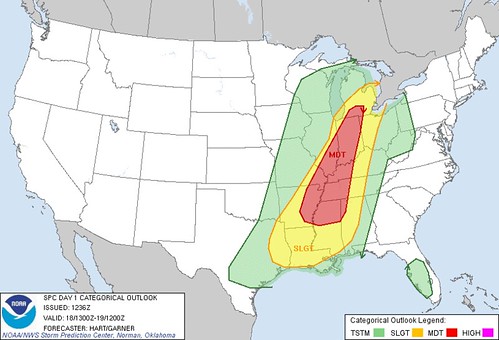
Moderate Risk
Typically, the SPC does not misfire on its prediction for severe weather when a moderate risk is issued. It's usually a rough time in or near the moderate risk areas.
It's a bit uncommon to have a moderate risk issued for northwest Ohio and/or southeast Michigan. Such a forecast may not happen every year for our region.
I don't recall any moderate risk forecasts for our area in 2012.
The Toledo area was under a moderate risk in May 2011, but I don't remember what happened that day.
The Toledo area was under a moderate risk on June 23, 2010, and severe weather rumbled through Monroe County.
The Toledo area was under a moderate risk on June 5, 2010, and that was the day, actually late night, when deadly tornadoes hit the region in two separate waves.
High Risk
What's really rare anywhere in the U.S. is for the SPC to issue a High Risk forecast for severe weather as indicated by magenta-colored legend in the above image.
At late morning or mid-day on March 6, 2012, the SPC issued a high risk forecast for parts of southeast IN, western KY, and southwest OH, and later that afternoon and evening, those areas had a tornado outbreak that killed several people. The SPC issued a moderate risk for those area in the early morning, but they upgraded it to a high risk by Noon or early afternoon that day.
Slight Risk
Several times a season, the Toledo area gets issued Slight Risk forecast for severe weather by the SPC. The SPC issues these forecasts very early in the morning. The Cleveland National Weather Service will issue a Hazardous Weather Outlook for the Toledo area if the SPC has issued a slight risk forecast (or greater) for our area.
Generally, slight risk forecast areas are much broader in coverage, and many times, nothing happens while other times, we do get strong storms.
Convective Outlooks
For the next several months, the SPC's early morning Convective Outlooks are a good source of info, regarding severe weather threats. Besides the current day's forecast, the SPC also issues convective outlooks for tomorrow and the next day.
- SPC Convective Outlooks - just take a quick glance at the map images, so you have an idea about severe weather threats for the day and next day.
- SPC Mesoscale Discussions - if you know that it could be a severe weather day, these detailed discussions can precede the issuance of a watch box, or it's an update about existing weather moving through a current watch box. As JustaSooner mentioned above, a mesoscale discussion currently exists that includes northwest Ohio.
Area Forecast Discussion
Although it's a bit technical and hard to read with its all-caps, the Area Forecast Discussion issued by the Cleveland National Weather Service is worth at least a fast browse on any day.
Watches
Remember, the SPC issues Severe Thunderstorm Watches and Tornado watches. These watch-boxes are issued for large regions that include many counties. And they are usually issued for a six-hour period, but that can vary. The watch means the likelihood exists that severe thunderstorms or tornadoes could occur in the watch box.
Warnings
Severe Thunderstorm Warnings and Tornado Warnings are issued by the regional National Weather Service. The warnings can be issued for an entire county or for only a portion of a county. And the warnings usually exist for 60 minutes. Obviously, the warnings mean severe weather is imminent for the warned area.
National Weather Service Offices
JustaSooner has mentioned in the past about how Toledo is in an unfortunate black hole, regarding radar and National Weather Service coverage.
Three different National Weather Service offices issue forecasts, warnings, and advisories for the immediate Toledo area.
The Detroit/Pontiac NWS covers Monroe and Lenawee counties.
The northern Inidan NWS coveres Fulton and Henry counties.
The Cleveland NWS covers Lucas, Wood, and Ottawa counties.
Toledo is at the very edge of coverage for all three offices. This can lead to confusing or variable forecasts for the immediate Toledo area, especially during winter events.
When a line of thunderstorms moves through, it "seems" to me that the northern Indiana NWS office is more likely to issue a warning than the other offices. So has the
It will never happen, but Toledo Express Airport should get back its own NWS forecasting office.
Sirens
As we learned in June 2010, the tornado sirens are NOT designed to be heard by people inside a home or a building with the TV, stereo, vacuum cleaner, or air conditioner running.
The sirens are meant to warn people who are outside.
Some sirens will malfunction.
The sheriff's office is charged with sounding the sirens. The sheriff is suppose to sound the siren if the county is under a tornado warning.
But we also learned in June 2010, that the sheriff can sound the siren at his or her own discretion, depending upon the severity of the advancing weather. The sheriff does not have to wait for NWS to issue a tornado warning for the county.
As mentioned above, the NWS could issue a tornado warning for only a portion of a county. But when the sirens sound, I think they sound throughout the entire county.
A couple years ago, the Cleveland NWS issued a tornado warning that included the extreme southeast corner of Wood County, but the sirens sounded in northern Wood County too. Rossford and Perrysburg weren't close to the storm cell and under no threat for severe weather.
Weather-wise
With the Internet, mobile devices, and text alerts, it's easy to be informed about the weather. And I'm not talking about when a storm is about to hit. It's easy to be aware several hours or a day in advance of severe weather.
But even today, many people don't understand the difference between "watch" and "warning."
PDS
One more thing about today's weather. Currently, the SPC has issued three tornado watches, that stretch from central Michigan to southern Arkansas.
Tornado Watch 123 that exists for a large portion of Indiana and the northwest Ohio counties has a special status attached to it: PDS - Particularly Dangerous Situation.
So some tornado watches are considered worse than others. Not all get the PDS status.
But at this moment, not a single county under Tornado Watch 123 is warned, so thus far, the line of storms has not been as strong as expected.
From JR's : articles
1114 words - 6664 chars
- 6 min read
created on
updated on
import date 2013-08-12 21:49:49
- #
source
- versions
- backlinks