Fri, Jan 23, 2015 Weather Info
To view the above GFS info, visit this link ...
http://www.tropicaltidbits.com/analysis/models
... then scroll down and at the lower left, click on "Precip/Moisture" and select "Total Snowfall."
Then on the right hand side of the page under "Select a Forecast Hour," click on "072." That will show the forecast snowfall amounts that should exist by 12z (7:00 a.m. EST) on Monday.
On the right side of the page, the select-dropdown currently reads "12z Friday, Jan 23." That's when the current model was last run. You can select previous model runs to see how the snowfall predictions have varied.
The next run will occur at 1:00 p.m., but the updated data does not appear on the website until three to four hours later. So check back after 5:00 p.m.
When the select-dropdown reads "18z Friday, Jan 23" then click the 66-hour forecast button. You want the forecast map to say "valid at 12z Mon, Jan 26, 2015."
Other maps
At 2:55 a.m. today, the Weather Prediction Center's 'Winter Weather Desk' issued these snowfall predictions for a 24-hour period, ending at 7:00 a.m., Mon, Jan 26.
View the data at
http://www.wpc.ncep.noaa.gov/wwd/winter_wx.shtml
They should issue new forecasts later this afternoon. Here are the ones from early this morning.
80 to 90 percent chance of a snow accumulation of at least two inches.

50 to 70 percent chance of a snow accumulation of at least four inches.

20 to 40 percent chance of a snow accumulation of at least six inches.

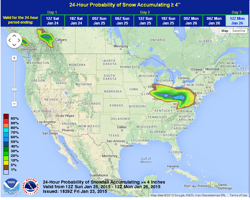
Maps below contain the latest Winter Weather Desk forecasts from the Weather Prediction Center as of about 1:30 p.m. EST on Fri, Jan 23, 2015.
These are 24-hr snowfall predictions for the period 7:00 a.m., Sun to 7:00 a.m., Mon.
Our expected snowfall seems to be around 2 to 3 inches. The heaviest snowfall is forecast to occur south of us.
At the moment, this appears to be a non-event for Toledo as Sunday's weather will not meet Winter Weather Advisory criteria. By now, we should be able to deal with a two-inch snowfall.
The latest forecast also predicts wind speeds on Sunday and Sunday night to be lower than previously thought, so blowing snow may not be an issue.
Cle NWS - Toledo Forecast - Last Update: Fri, Jan 23, 2015 1:02 pm
Sunday: Snow. High near 29. Northeast wind 11 to 16 mph. Chance of precipitation is 90%.
Sunday Night: Snow likely, mainly before 1am. Cloudy, with a low around 14. Chance of precipitation is 60%.
Monday: A chance of snow before 1pm. Mostly cloudy, with a high near 21. Chance of precipitation is 30%.
It's still worth checking the forecast on Saturday for possible changes in the track of the low pressure. Even if the low wobbles a bit more to the north so that Toledo would get the bulk of the snow, it appears that it would accumulate only 4 to 5 inches.

50 to 80 percent chance of snow accumulating at least 2 inches.

Only a 10 to 30 percent chance of snow accumulating at least 4 inches.
Little chance for snow to accumulate at least 6 inches.

From JR's : articles
521 words - 3021 chars
- 2 min read
created on
updated on
- #
source
- versions