You're viewing old version number 2. - Current version
Apr 10, 2015 Weather Notes
Our temps have cooled a little. At 4:00 a.m., TOL reported 68 degrees. At 8:00 a.m., TOL reported 49.
Temps are forecast to be in the mid 30s by Saturday morning, but the weekend looks decent.
Saturday: Sunny, with a high near 57.
Sunday: Mostly sunny, with a high near 63.
High temps in the 60s are forecast to continue through next Thursday.
Storm summary info from the CLE NWS and a Toledo Blade story.
Hail
0808 pm 04/09/2015
whitehouse 41.52n 83.80w
estimated hail size diameter of 0.75 inches reported by trained spotter
0828 pm 04/09/2015
s perrysburg 41.55n 83.62w
measured hail size diameter of 1.50 inches by trained spotter
Funnel Clouds
A National Weather Service survey crew will be dispatched to Lucas County and and northern Wood County today to assess damage and see whether any of the numerous reports of funnel clouds and some reports of tornadoes on the ground could be confirmed, according to the weather service.
Late Afternoon storm
0506 pm 04/09/2015
north baltimore 41.18n 83.68w
funnel cloud reported by law enforcement
reports of a funnel cloud aloft
0506 pm 04/09/2015
north baltimore 41.18n 83.68w
funnel cloud reported by a trained spotter
funnel cloud was caught on camera, and it remained aflot
0515 pm 04/09/2015
fostoria 41.16n 83.41w
funnel cloud reported near fostoria by the emergency manager
Area residents reported seeing funnel clouds about 4:53 p.m. between the villages of Van Buren in Hancock County and North Baltimore in Wood County, said a Hancock County sheriff’s dispatcher. A funnel cloud was also reported about 5:24 p.m. east of Fostoria, a Fostoria police dispatcher said.Martin Thompson, a hydrometeorologic technician with the National Weather Service in Cleveland said reports showed none of the funnels touched down.
Weather forecasters have said a severe thunderstorm capable of producing a tornado was located about 5 miles northwest of Fostoria and moved east at 45 mph. The weather service also reported 60 mph wind gusts and nickel-sized hail in that area.
Mid-evening Storm
0814 pm 04/09/2015
funnel cloud reported by trained spotter near e maumee 41.57n 83.65w
0815 pm 04/09/2015
funnel cloud reported by trained spotter southwest of walbridge 41.59n 83.49w
A tornado was reported on the ground along State Rt. 795 in Lake Township before 8:30 p.m. and then near Dunbridge and Reitz roads. There were no reports of injury or property damage. Wood County sheriff’s deputies reported utility poles were down along State Rt. 199 near Lime City Road.In Ottawa County, where spotters reported a tornado on the ground in the Genoa area about 8:40 p.m., sheriff’s deputies reported no damage or injury.
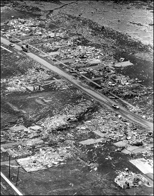
Tomorrow, Apr 11, is the 50-year anniversary of the Palm Sunday tornado that hit Toledo.
- Apr 5, 2015 Toledo Blade story
- Cle NWS posting
- Wikipedia page
- Blog
- YouTube - "Thirty Seconds to Eternity" - WTOL-TV, 1965 - Documentary
- YouTube - Death Out Of Darkness - 1965 Palm Sunday Tornadoes - 25 minutes
Excerpts from the above sources. Some details seem to vary.
The Palm Sunday Tornado outbreak occurred on April 11-12, 1965, across the states of Illinois, Indiana, Iowa, Ohio, Michigan and Wisconsin. 47 Tornadoes (15 significant, 17 violent, and 21 killers), wrecked havoc upon the land. It is the third deadliest tornado outbreak on record with 261 deaths.The only tornado on April 11 to touch down in a large city hit Toledo at about 9:30 PM. It cut a six-mile long path across the northern edge of Toledo.
A double tornado was sighted near Toledo, Ohio. The same weather system devastated northern parts of the city with F4 tornado damage. Five people were killed when a tornado flipped over a bus on the Detroit-Toledo Expressway (today's Interstate 75).
A string of tornadoes ripped through the Midwest on April 11, 1965, killing 271 people; 54 deaths were reported in Ohio, 15 of them in Toledo. There were so many bodies that Toledo Fire Station 24, which was then at Summit and 114th streets in Point Place, was turned into a makeshift morgue where families could identify their loved ones. Another 208 people were injured.
Damage from the storm was estimated at $12 million, which now would equate to about $90 million when adjusted for inflation. The tornado cut a 10-mile-long path of destruction from West Toledo to the northern point of the city.
One development, Fuller’s Creekside Addition in Point Place, was entirely leveled. In all, 310 families were left homeless, 117 homes were destroyed, 145 were badly damaged, and 45 farm, commercial, and industrial structures were damaged.
The tornado touched down in Toledo at about 9:30 p.m., moving northeast from Monroe Street and Secor Road, along Sylvania Avenue, across Tremainsville Road, down Eleanor Avenue, and across Laskey Road, Telegraph Road, and Stickney Avenue. After smashing Fuller’s, the tornado continued into the Lost Peninsula just across the Michigan line before it dissipated over Maumee Bay.
"Toledo professional photographer Jim Weyer took this photo of the Palm Sunday tornado that appeared in Life magazine."
More Blade photos
From JR's : articles
845 words - 5211 chars
- 4 min read
created on
updated on
- #
source
- versions

