You're viewing old version number 18. - Current version
Toledo weather mon jun 22 2015
spc ac 220558
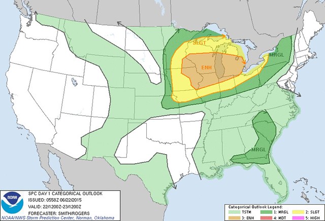
day 1 convective outlook
nws storm prediction center norman ok
1258 am cdt mon jun 22 2015
valid 221200z - 231200z
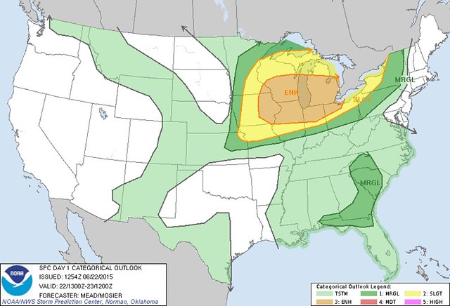
...there is an enh risk of svr tstms from the mid-upper ms valley
ewd into lower mich...
...there is a slgt risk of svr tstms over a large portion of the
midwest and great lakes...
...there is a mrgl risk of svr tstms from ern ks into the
northeastern u.s....
...there is a mrgl risk of svr tstms over nrn parts of fl into the
wrn carolinas...
...summary...
scattered severe storms are likely across parts of the upper
mississippi valley and great lakes regions...some of which should be
intense...mainly from midday through the evening on monday. the
threat for large to very large hail and a strong tornado appear to
be greatest over southern wisconsin and northern illinois.
...upper ms valley/great lakes...
considerable uncertainty remains regarding the forecast evolution of
a severe mcs across the nrn plains into the upper ms valley prior to
the start of the period. as a result...confidence for this severe
forecast is tempered owing to several potentially critical variables
1) longevity/severity of early morning mcs from the ms valley into
the great lakes 2) preferred storm mode /supercell and/or bow echo/.
given relatively high uncertainty...will defer substantial changes
to the next outlook.
the primary shortwave trough will move from the nrn plains to lake
superior during the day while a potential convectively-generated mcv
evolves from squall line activity leading into the day 1 period. in
the low levels...a reservoir of rich moisture over the lower to mid
mo valley will advect n/newd into the mid ms valley/wrn great lakes
during the morning owing partially to strong low-level waa. while
it is possible for the early morning storms to continue ewd from the
mid-upper ms valley into the cntrl great lakes...lessening buoyancy
with ewd extent should serve to weaken this activity. a strong
influx of low-level moisture /characterized by 16-18 g per kg lowest
100 mb mean mixing ratios/ will likely move into nrn il/wi vicinity
along and to the s of trailing outflow and ahead of the approaching
cold front.
it is probable storm redevelopment /sctd coverage/ will occur later
in the afternoon near the residual boundary over the wrn great lakes
or along the front located over cntrl wi sw into ern ia. the
strength of the deep layer shear vector /50-70 kt/ and its
orientation to the boundary coupled with a very strong to extremely
buoyant /3000-4500 j per kg mlcape/ boundary layer would promote
explosive updraft development and a supercellular mode early in the
storm lifecycle. all severe hazards would be possible with this
activity...including significant hail/wind/tornado. further storm
development along the front will favor a transition to a mixed mode
and probably yield a wind/hail threat becoming predominate with
time. storms should move downstream and into the srn and lower
great lakes states overnight with the primary risk being isold large
hail/wind.
...parts of the sern u.s...
a flattened mid-level anticyclone will persist off the se u.s. and
diurnally-driven storms will likely develop during the afternoon. a
very weak wind profile will result in slow-moving pulse storms which
will likely propagate on convective outflow. steepened low-level
lapse rates owing to strong diabatic heating coupled with pw
1.75-2.0 inches will promote water loading with the more intense
cores. wet microbursts capable of pockets of wind damage will be
the primary threat and this activity will diminish during the early
evening.
..smith/rogers.. 06/22/2015
click to get wuus01 ptsdy1 product
note: the next day 1 outlook is scheduled by 1300z
According to the 1:58 a.m. SPC update, the main threat for severe weather remains to the north and west of Toledo. And it seems that some aspects for severe weather have decreased for Michigan. The main risk for tornadoes and large hail exists over southern WI, northern IL, and eastern IA. But it appears that the NWS won't know for sure until mid-day.
Excerpts from the 1:58 a.m., Mon, Jun 22 Day 1 Convective Outlook:
...upper ms valley/great lakes...considerable uncertainty remains regarding the forecast evolution of a severe mcs across the nrn plains into the upper ms valley prior to the start of the period.
as a result... confidence for this severe forecast is tempered owing to several potentially critical variables
1) longevity/severity of early morning mcs from the ms valley into the great lakes
2) preferred storm mode /supercell and/or bow echo/.
given relatively high uncertainty... will defer substantial changes to the next outlook.
the next day 1 outlook is scheduled by 1300z [9:00 a.m. EDT]
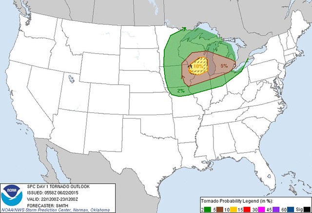
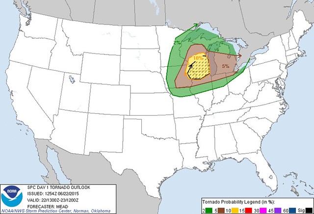
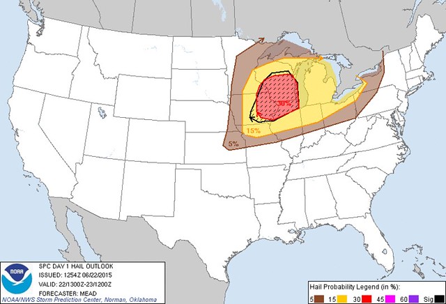
Probability of a tornado within 25 miles of a point. Hatched Area: 10% or greater probability of EF2 - EF5 tornadoes within 25 miles of a point.
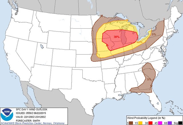
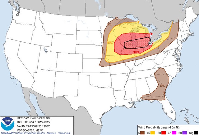
Probability of damaging thunderstorm winds or wind gusts of 50 knots or higher within 25 miles of a point. Hatched Area: 10% or greater probability of wind gusts 65 knots or greater within 25 miles of a point.
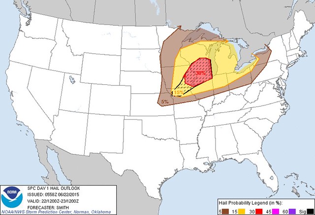
Probability of one inch diameter hail or larger within 25 miles of a point. Hatched Area: 10% or greater probability of two inch diameter hail or larger within 25 miles of a point.
fxus63 kdtx 220635
afddtx
area forecast discussion
national weather service detroit/pontiac mi
235 am edt mon jun 22 2015
short term...today and tonight
today (through approximately 02z)
an mcs is maturing over south dakota at press time in response to
the previously discussed strong dynamic response across the northern
united states and subsequent low-level jet response. surface
pressure falls in the lee of the rockies are forecast to consolidate
into a low pressure center over minnesota early this morning with
the attendant instability axis along the arcing warm front providing
a focus for continued mcs propagation.
classic conceptual model suggests the mcs will enter the decaying
stage upon weakening of the nocturnal jet and as it outruns synoptic
scale forcing during the morning. however, the present situation
suggests pause given strong dynamic response accompanying a rapid
synoptic scale evolution. high resolution models place the mcs on
the expected ese trajectory over southern wisconsin by late this
morning. low-level jet will only strengthen through the morning into
this afternoon as the warm front lifts north. extrapolation puts
perhaps the northern fringes of the mcs over south-central lower
michigan by mid-afternoon, where the surface instability axis will
already be firmly in place. any organized severe wind threat would
likely only clip southwestern counties 20-00z.
more likely scenario for this afternoon will be the potential for
lead discrete development along the warm front in advance of
mcs/remnants, possibly along mcs outflow propagating into the warm
sector environment. updrafts along the warm front itself may
initially struggle to organize and root in the boundary layer given
unfavorable position along the periphery of the more favorable warm
sector environment. better chance for a severe threat may come in
response to updraft development along outflow or simply a result of
ongoing theta-e advection within the warm sector. despite being
shrouded in convective debris for the bulk of the day, advective
processes will ensure mlcape ramps up to 2000-3000 j/kg 19-00z,
during which time hodographs will become increasingly large and
formidable with any post-warm front development likely becoming
severe. the initial threat before sundown will be large hail to golf
ball size and winds to 60 mph. lcls upwards of 3kft not particularly
supportive of tornado development during this period. coverage may
be increased toward the saginaw valley where mcv within corridor of
greatest synoptic scale height falls, and immediately downstream of
the surface low will provide stronger forced ascent. defined lull in
activity is a reasonable expectation during mid evening hours
probable given mcs passage and resultant mid-level latent heat
bubble/stabilization and wake subsidence. concern that this stable
period will short circuit cold front convection later in the night
exists, but is minimal at this time given very strong advective
processes and fast evolution of features on the synoptic scale.
tonight (approx 02-12z)
aforementioned potential mcs disruption not withstanding, severe
threat will fully mature during the late evening as 50kt swly llj
and 70kt 500mb wind max become juxtaposed with extremely buoyant
environment immediately in advance of the surface cold front.
incredible 0-6km bulk shear of 60 to 65 knots oriented favorably
to the initiating boundary, combined with lack of strong linear
forcing, and mlcape of 2000 j/kg or higher will favor an initial
mode of supercells over central lower michigan into the saginaw
valley and locations north of m59. 0-1km/0-3km srh of 250/330 m2s2
respectively suggest very strong mesocyclone rotation capable of
producing hail to golf balls or higher, though elevated freezing
levels warrant remaining conservative with regard to hail
potential. in addition, a legitimate tornadic threat would also
exist during the supercell phase as lcls lower with the help of
advection of rich low-level moisture and decreased mixing during
the nocturnal period. incredibly high vgp around 1 is a testament
to the magnitude of shear available for tilting while sufficient
cape in the lowest levels looks to be available to enhance
stretching processes. a few tornados cannot be ruled out mainly
north of m59. magnitude of environmental wind field alone will
also support straight line wind gust potential to 70 mph.
passage of the upper wave will result in rapid veering of the wind
profile over southeast michigan after about 05z leading to
increasingly straight hodographs as convection shifts toward the
southern half of the cwa. as such, an evolution from supercells to a
more downdraft dominated convective mode is expected during this
time. cold pool interaction would favor some consolidation, with the
forecast thermodynamic environment favoring bowing segments with
rear inflow jets over significant upscale growth. thus, the primary
threat south of m59 appears to be largely a wind threat. certainly a
very dynamic and fluid forecast situation with additional
modifications to the official forecast reasoning anticipated during
the next 12 hours.
&&
long term...tuesday through sunday
surface ridging tucked beneath continuous lower amplitude west-
northwest mid level flow will result in a period of drier and more
stable conditions tuesday and tuesday night. a limited period of
weak cold air advection will be offset by the high regree of
insolation within a modestly mixed environment. this will support
highs of upper 70s and lower 80s. gradual boundary layer drying
will provide a noticeable decrease in humidity by the latter half
of the day.
large scale pattern will deviate little heading into wednesday. west
to east elongated strip of greater moisture/instability will remain
anchored to the south through the daylight period...with additional
shortwave energy working through this mean flow providing a focal
point for continued convective development over the midwest/ohio
valley. this positioning will sustain a higher degree of stability
locally under deeper westerly flow. pattern peristence in the
temperature department...highs again arriving within a degree or
two on either side of 80 degrees.
emerging warm air advection across the plains will favor some
northeastward expansion of the main theta-e plume with time
wednesday into thursday. this evolution could be augmented/enhanced
by the passage additional shortwave energy. this will offer the
next possibility for shower and thunderstorm development
locally...centered sometime within the wednesday night and thursday
periods.
&&
marine...
southerly winds will then increase today as strong low pressure
tracks toward the northern great lakes. this system will bring the
potential for strong to severe thunderstorms from late afternoon
through tonight. while thunderstorms will be the primary
concern...there will also be a period of stronger west to northwest
winds along and behind a cold front tonight into tuesday. gust
potential will be limited somewhat by stability over the cooler lake
waters. however there will be the potential for some gusts to 30
knots across the open waters of lake huron...with 25 knots down
through saginaw bay. this warrants the issuance of a small craft
advisory for saginaw bay and along the tip of the thumb. the wind
will decrease by late tuesday and tuesday night as high pressure
builds into the region.
&&
prev discussion...issued /
&&
dtx watches/warnings/advisories...
mi...none.
lake huron...none.
lake st clair...none.
michigan waters of lake erie...none.
&&
$$
short term...jvc
long term....mr
marine.......mr
you can obtain your latest national weather service forecasts online
at www.weather.gov/detroit (all lower case).
According to the 1:58 a.m. SPC update, the main threat for severe weather remains to the north and west of Toledo. And it seems that some aspects for severe weather have decreased for Michigan. The main risk for tornadoes and large hail exists over southern WI, northern IL, and eastern IA. But it appears that the NWS won't know for sure until mid-day.
Excerpts from the 1:58 a.m., Mon, Jun 22 Day 1 Convective Outlook:
...upper ms valley/great lakes...considerable uncertainty remains regarding the forecast evolution of a severe mcs across the nrn plains into the upper ms valley prior to the start of the period.
as a result... confidence for this severe forecast is tempered owing to several potentially critical variables
1) longevity/severity of early morning mcs from the ms valley into the great lakes
2) preferred storm mode /supercell and/or bow echo/.
given relatively high uncertainty... will defer substantial changes to the next outlook.
the next day 1 outlook is scheduled by 1300z [9:00 a.m. EDT]
Probability of a tornado within 25 miles of a point. Hatched Area: 10% or greater probability of EF2 - EF5 tornadoes within 25 miles of a point.
Probability of damaging thunderstorm winds or wind gusts of 50 knots or higher within 25 miles of a point. Hatched Area: 10% or greater probability of wind gusts 65 knots or greater within 25 miles of a point.
Probability of one inch diameter hail or larger within 25 miles of a point. Hatched Area: 10% or greater probability of two inch diameter hail or larger within 25 miles of a point.
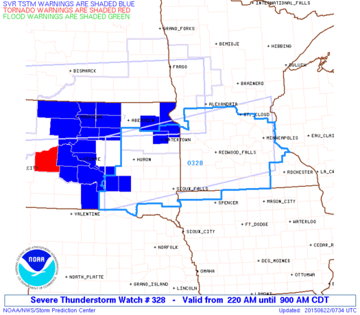
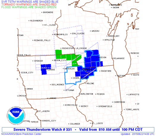
The cluster of strong storms located at 3:30 a.m. over the Dakotas and Minnesota may reach the lower Great Lakes later today.
Warnings as of 3:34 a.m. EDT.
Excerpts from the 2:35 a.m., Mon, Jun 22 AFD issued by the Det/Pon NWS, which is generally more informative than information from the Cle NWS, which seems to show little interest in Lucas County's weather.
This AFD suggests that the worse weather for central and southern Michigan will occur after dark. Two rounds of storms may pass through Michigan. Thunderstorm scraps may reach the Toledo area after Midnight.
an mcs is maturing over south dakota at press time in response to the previously discussed strong dynamic response across the northern united states and subsequent low-level jet response.high resolution models place the mcs on the expected ese trajectory over southern wisconsin by late this morning. low-level jet will only strengthen through the morning into this afternoon as the warm front lifts north. extrapolation puts perhaps the northern fringes of the mcs over south-central lower michigan by mid-afternoon, where the surface instability axis will already be firmly in place. any organized severe wind threat would likely only clip southwestern counties 20-00z.
more likely scenario for this afternoon will be the potential for lead discrete development along the warm front in advance of mcs/remnants, possibly along mcs outflow propagating into the warm sector environment.
the initial threat before sundown will be large hail to golf ball size and winds to 60 mph. lcls upwards of 3kft not particularly supportive of tornado development during this period.
defined lull in activity is a reasonable expectation during mid evening hours probable given mcs passage and resultant mid-level latent heat bubble/stabilization and wake subsidence.
... severe threat will fully mature during the late evening ...
... will favor an initial mode of supercells over central lower michigan into the saginaw valley and locations north of m59.
... suggest very strong mesocyclone rotation capable of producing hail to golf balls or higher ...
... a legitimate tornadic threat would also exist during the supercell phase ...
a few tornados cannot be ruled out mainly north of m59. magnitude of environmental wind field alone will also support straight line wind gust potential to 70 mph.
[after 1:00 a.m. Tue] the primary threat south of m59 appears to be largely a wind threat.
certainly a very dynamic and fluid forecast situation with additional modifications to the official forecast reasoning anticipated during the next 12 hours.
hazardous weather outlook
national weather service cleveland oh
454 am edt mon jun 22 2015
for lake erie...north central
ohio...northeast ohio...northwest ohio and northwest pennsylvania.
.day one...today and tonight.
severe thunderstorms are expected to develop across the central
great lakes today. these storms will likely move toward lake
erie and eventually into northern ohio and northwestern
pennsylvania. it is tough to tell at this time how long and how
far east the severe storms will persist. the best chance for
severe storms appears to be across northwest ohio this evening.
wind damage and large hail will be the greatest threat although a
tornado is possible.
.days two through seven...tuesday through sunday.
no hazardous weather is expected at this time.
.spotter information statement...
spotter activation is not expected at this time.
area forecast discussion
national weather service northern indiana
603 am edt mon jun 22 2015
synopsis...
issued at 300 am edt mon jun 22 2015
severe storms are possible this afternoon tonight...especially
from far southern lower michigan into northern indiana and
northwest ohio as a strong upper level system tracks eastward
through the great lakes. highs today will generally be in the
upper 80s. lows tonight will be in the upper 60s to lower 70s.
loop ending at 8:52 a.m. EDT

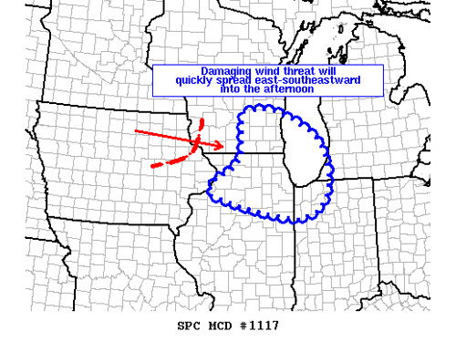
MESOSCALE DISCUSSION 1116
NWS STORM PREDICTION CENTER NORMAN OK
0742 AM CDT MON JUN 22 2015
AREAS AFFECTED...EAST-CENTRAL AND SOUTHEAST MN...NORTHERN AND
EASTERN IA...WEST-CENTRAL/SOUTHWEST AND SRN WI AND PART OF NRN IL
CONCERNING...SEVERE THUNDERSTORM WATCH 328...329...330...
VALID 221242Z - 221415Z
THE SEVERE WEATHER THREAT FOR SEVERE THUNDERSTORM WATCH
328...329...330...CONTINUES.
SUMMARY...STRONG AND DAMAGING WINDS REMAIN A THREAT ACROSS SOUTHEAST
AND EAST-CENTRAL MN...NORTHEAST IA AND WEST-CENTRAL/SOUTHWEST WI.
STORMS CONTINUING TO DEVELOP NEAR AND NORTH OF A WARM FRONT FROM
SOUTHEAST MN THROUGH NORTHEAST IA AND SOUTHWEST WI AHEAD OF THE BOW
WILL POSE A THREAT FOR LARGE HAIL AND DAMAGING WINDS. IN
ADDITION...STRONG TO SEVERE N/NWLY WIND GUSTS REMAIN A POTENTIAL
THREAT ATTENDANT TO A WAKE LOW WEST OF THE BOW.
A NEW WW MAY BE NEEDED DOWNSTREAM OF THE BOW AS IT SHOULD PROGRESS
E/SEWD THIS MORNING INTO PARTS OF ERN IA...SRN WI AND NRN IL.
DISCUSSION...AT 12Z...MOSAIC RADAR IMAGERY INDICATED A COMPLEX
DISPLAY OF STORMS ACROSS CENTRAL AND SOUTHERN MN INTO NORTHERN IA
AND DEVELOPING EWD INTO WEST-CENTRAL AND SOUTHWEST WI. A BOW
EXTENDED FROM NEAR OR JUST SOUTH OF THE TWIN CITIES METRO SSWWD INTO
NORTH-CENTRAL IA AND WAS MOVING TO THE EAST/EAST-SOUTHEAST AT 50-60
KT. A 50 KT SWLY LLJ AS SAMPLED BY THE DMX/OAX WSR-88D/S WILL
RESULT IN FURTHER STRONG LOW-LEVEL WAA AND A FEED OF
MODERATELY-STRONG INSTABILITY INTO THE SRN EXTENT OF THE UPPER MS
VALLEY MCS.
A VERY STRONG /AROUND 90 KT/ AND DESCENDING REAR-INFLOW JET AS
OBSERVED EARLIER WITH THE FSD WSR-88D INDICATED WILL CONTINUE TO
ENHANCE THE SEVERE AND DAMAGING WIND THREAT WITH THE BOW.
OTHERWISE...STORMS WILL ALSO CONTINUE TO DEVELOP NEAR A WARM FRONT
IN SOUTHEAST MN/NORTHEAST IA INTO SWRN AND SRN WI THIS MORNING AS
THIS FRONT MOVES TO THE NORTH. GIVEN THE POTENTIAL FOR THE PORTION
OF THE BOW IN NORTH-CENTRAL IA TO SPREAD INTO ERN IA/SRN WI AND NRN
IL AFTER 14Z...A NEW WW MAY NEED TO BE ISSUED THIS MORNING...SOUTH
THROUGH EAST OF WW 330.
spc ac 221254
day 1 convective outlook
nws storm prediction center norman ok
0754 am cdt mon jun 22 2015
valid 221300z - 231200z
...there is an enh risk of svr tstms over a part of the upper
midwest and upper great lakes region...
...there is a slgt risk of svr tstms surrounding the enh risk from
the upper ms and lower mo valleys ewd through the great lakes...
...there is a mrgl risk of svr tstms surrounding the slgt risk from
the upper ms and lower mo valleys ewd through the great lakes...
...there is a mrgl risk of svr tstms over a portion of the sern
states...
...summary...
severe storms capable of intense...damaging outflow winds...strong
tornadoes and very large hail are probable over the upper midwest
and great lakes region today through tonight.
...synopsis...
a polar-branch short-wave trough from manitoba into the dakotas will
amplify and gradually assume a slight negative tilt as it translates
through the great lakes and ontario. this system will be attended
by a 70-80 kt mid-level jet streak and corridor of 50-100 m/12-hr
height falls at 500 mb which will overspread the great lakes later
today into tonight.
at the surface...an associated area of low pressure will deepen
while developing from swrn mn into ern ontario/wrn quebec by
12z/tuesday. a warm front which will be modulated by convective
outflow attendant to early-day storms will attempt to move nwd into
the great lakes while a trailing cold front sweeps ewd through the
upper ms valley and upper great lakes. the trailing extension of
this front will move more slowly sewd through the mid/lower mo
valley and cntrl plains.
...upper midwest ewd through the great lakes and nrn oh valley...
a complex-structured mcs ongoing over srn mn/nrn ia will continue
ewd along the synoptic warm front through portions of cntrl/srn wi
and nrn il this morning...and eventually into lower mi by afternoon.
this system has a well-defined mcv with the fsd vad indicating
60-80 kt winds within the descending rear-inflow jet at 1 km agl.
given the very moist and moderately unstable air mass feeding into
this system along a 40-50+ kt swly llj...expect damaging wind
potential to persist...and possibly increase later today as the
boundary layer warms and destabilizes.
due to the expansive cold pool generated by the mcs...considerable
uncertainty remains with regard to the intensity and location of
diurnally enhanced tstm development this afternoon. a number of
convection-allowing models suggest that storms will redevelop by
early afternoon along the cold front from portions of w-cntrl wi
into n-cntrl/nern ia as large-scale forcing for ascent/dcva
overspreads the area. while the character of the thermodynamic
environment remains unclear...both low-level and deep-layer shear
will be quite strong /i.e. effective values of bulk shear and srh of
50-60 kt and 300-400 m2 per s2...respectively/ and supportive of
supercells capable of large hail and tornadoes /some possibly
strong/...namely over cntrl/srn wi into nern ia and nrn il.
other storms may develop later today from the vicinity of the cold
front ewd along the outflow boundary trailing the early-day mcs from
portions of ia into nrn il. and while a favorable overlap of
3000-4000+ j/kg mlcape and strong vertical shear will
exist...pronounced capping /see the 12z oax sounding/ may become
problematic to storm development...especially if the boundary
continues to settle swd. as such...a conditional risk for
supercells capable of very large hail...a few tornadoes and damaging
winds will exist given diurnal storm development and sustenance.
by this evening...ongoing storms along the cold front may
consolidate into a mixed-mode mcs /i.e. embedded supercells and
bows/ with the threat for damaging winds...large hail and possibly a
tornado or two spreading sewd across cntrl/srn lower mi and portions
of il...ind...oh. this mcs may affect parts of the lower great
lakes late tonight into early tuesday.
an upgrade to a moderate risk remains possible in later day one
outlooks...once mesoscale details regarding the destabilization
process in the wake of the mcs become more clear.
...sern states this afternoon/evening...
heating along the high terrain and convergence along residual
outflow boundaries will give rise to scattered afternoon storms
amidst a very moist and moderately unstable air mass. vertical
shear will be weak...but considerable water loading of convective
downdrafts and resultant risk for isolated damaging surface winds.
..mead/mosier.. 06/22/2015
click to get wuus01 ptsdy1 product
note: the next day 1 outlook is scheduled by 1630z
Wind: Probability of damaging thunderstorm winds or wind gusts of 50 knots or higher within 25 miles of a point. Hatched Area: 10% or greater probability of wind gusts 65 knots or greater within 25 miles of a point.
SIG SEVERE 44,721 20,825,015 Chicago, IL...Detroit, MI...Milwaukee, WI...Toledo, OH...Madison, WI...
The first batch of severe thunderstorms may move through our region late this afternoon or early this evening.
The second batch of severe thunderstorms may move through our region late tonight or early Tuesday morning. This nighttime event could contain worst weather than the first batch.
The map below concerns the first batch of severe thunderstorms.
SPC Day 1 Convective Outlook issued at 8:54 a.m. EDT on Mon, Jun 22, 2015 and valid until 8:00 p.m. tonight.
Wind Outlook: Probability of damaging thunderstorm winds or wind gusts of 50 knots or higher within 25 miles of a point. Hatched Area: 10% or greater probability of wind gusts 65 knots or greater within 25 miles of a point. Significant Severe weather: Chicago, IL... Detroit, MI... Milwaukee, WI... Toledo, OH ... Madison, WI...
Warnings as of 10:35 a.m. EDT. This cluster of storms has been severe since last night when the storms were over the Dakotas. The storms were moving east-southeast.

10:14 a.m. Mesoscale Discussion
Excerpts from the 8:54 a.m. Day 1 Convective Outlook.
an upgrade to a moderate risk remains possible in later day one outlooks once mesoscale details regarding the destabilization process in the wake of the [first] mcs become more clear.the next day 1 outlook is scheduled by 1630z [12:30 p.m. EDT].
Regarding the current batch of storms (MCS) that are approaching Chicago.
a complex-structured mcs ongoing over srn mn/nrn ia will continue ewd along the synoptic warm front through portions of cntrl/srn wi and nrn il this morning... and eventually into lower mi by afternoon.given the very moist and moderately unstable air mass feeding into this system along a 40-50+ kt swly llj... expect damaging wind potential to persist... and possibly increase later today as the boundary layer warms and destabilizes.
Concerning the second batch of storms that may develop later.
by this evening... ongoing storms along the cold front may consolidate into a mixed-mode mcs /i.e. embedded supercells and bows/ with the threat for damaging winds... large hail and possibly a tornado or two spreading sewd across cntrl/srn lower mi and portions of il... ind... oh. this mcs may affect parts of the lower great lakes late tonight into early tuesday.
From JR's : articles
4399 words - 28136 chars
- 24 min read
created on
updated on
- #
source
- versions