• 1417
• 1442
• 1452
• 1501
• 1503
• 1509
• 1513
• 1521
• 1525
• 1534
• 1540
• 1549
• 1632
• 1647
You're viewing old version number 20. - Current version
Severe weather threat for Sun, Nov 17, 2013 - Part 2
This post Severe weather threat for Sun, Nov 17, 2013 is getting to big, so continuing here.
Nov 17 - 1411
Short while ago


1417

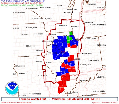
md 2018 concerning tornado watch 561...562...564... for far ern il...ind...lower mi
mesoscale discussion 2018
nws storm prediction center norman ok
0106 pm cst sun nov 17 2013
areas affected...far ern il...ind...lower mi
concerning...tornado watch 561...562...564...
valid 171906z - 172030z
the severe weather threat for tornado watch
561...562...564...continues.
summary...widespread damaging winds and several tornadoes...some of
which should be significant...will evolve from il into ind and lower
mi through mid-afternoon.
discussion...the nrn two-thirds of an extensive convective band has
consolidated into a qlcs from srn lk mi into e-cntrl il. with an
impressively large surface pressure rise/fall couplet noted across
the mid-ms valley to midwest...tendency for fast-moving linear
organization should continue across nrn ind and lower mi. embedded
mesovortices will remain capable of damaging tornadoes while
extensive swaths of strong to severe wind gusts should remain
attendant to the qlcs as an 886 mb surface cyclone over sern wi
continues to deepen.
farther s...tendency for more discrete supercell structures appear
probable for convection emanating newd out of srn il. although
downstream surface temperatures are cooler...very strong low-level
shear noted in kvwx vwp data will support a considerable risk of
significant tornadoes as convection remains coincident within a
plume of lower to middle 60s surface dew points.
..grams.. 11/17/2013
...please see www.spc.noaa.gov for graphic product...
attn...wfo...dtx...apx...lmk...iwx...grr...ind...pah...lot...
ilx...
lat...lon 44528595 44528470 44118430 43138440 39638542 38508650
38168746 38138787 38238832 38638834 40298780 42508673
44528595
1442
Toledo Express weather at 2pm.
Weather : Overcast
Temperature : 65 F
Humidity : 76%
Wind Speed : S 17 mph - Gust 30 mph
Barometer : 29.50 in
Dewpoint: 57 F
Visibility : 10.00 statute miles
1452

I'm seeing only a small amount of the white inside cells that indicate severe.


1501
A couple of those cells along or near the IL-IN border are isolated at least along the western and southern edges.


1503
This was prob posted in the other post:
fxus61 kcle 171738
afdcle
area forecast discussion
national weather service cleveland oh
1238 pm est sun nov 17 2013
synopsis...
low pressure over the plains states will deepen rapidly as it
moves northeast today reaching northern lake michigan by this
evening and into quebec on monday. this will push a strong cold
front across the area this evening. high pressure will move east
out of the southern plains states into the ohio valley by tuesday
and then off the east coast on wednesday.
&&
near term /until 6 pm this evening/...
removed thunder across north central ohio and points east until
very late afternoon/evening. while i cannot rule out thunder...
would like to make the thunder and wind with the front more of the
focal point of the forecast. tough to do in these days of
automated text formatters...so not sure exactly what the wording
will say. better chance for thunder at any time in the dry slot
that is creeping across northwest ohio. sort of looks like
oklahoma in the spring time...hmmm.
no other significant changes to the forecast. did nudge up high
temperatures a couple of degrees across nw ohio and parts of north
central ohio where there will not be as many showers. record high
in toledo is 71 and we will take a run at it. 72 at cle is
potentially within reach.
relevant early morning updated discussion...
showers continue to move east and out of the area at this time.
cellular convection continues to move into extreme northwest ohio
and southern lower michigan. the water vapor plume is also pushing
east allowing for some drier air to move east and allow for a
break in the action. latest hrrr model shows massive squall line
developing over illinois and rapidly intensifies as it moves east
toward ohio. timing would put the line at toledo and findlay at
22z and to cleveland and mansfield by about 00z and finally to
erie and youngstown by 02z or so. so the wait begins. stay tuned.
previous discussion...
the long anticipated severe weather threat day has arrived. two low
pressure systems in the upper midwest are beginning to merge and
intensify this morning.
southerly flow has increased across the forecast area and this will
be the beginning of the strengthening wind flow throughout the day.
moderately strong low level jet will remain persistent over the
forecast area today and with the warm air advection...some of the
stronger winds will mix down to the surface. so...will go ahead and
issue a wind advisory for the entire area but will be for mainly
later this evening into tonight since the strongest winds will take
place after the cold frontal passage.
60 to 70 knot speed maximum at 850 mb will pose a problem as
convection develops later this morning into the afternoon hours. the
stronger winds could be forced to the surface in the thunderstorms
and produce widespread wind damage. latest storm prediction center
outlook continues to highlight a moderate risk for severe
thunderstorms across the area today. there is a high risk just west
of the forecast area.
even though the main threats will be the strong damaging
winds...latest model sounding hodographs indicate some fairly high
levels of helicity...especially across areas from cleveland to akron
canton west. i cant rule out the potential for any thunderstorms
that develop that they could begin to rotate rather quickly and
produce tornadoes. temperature dew point spreads are progged to be
at or below the 5 degree threshold and this is one key ingredient
for tornadoes to develop.
&&
short term /6 pm this evening through wednesday night/...
the severe weather threat will not be over tonight. the cold front
and potential squall line is expected to move through the area this
evening and this is when we have the highest threat for widespread
wind damage. one factor is we will be losing the day time heating
and this may help to stabilize things a bit.
as the cold front shifts east...cold air advection will take place
and allow winds to mix down to the surface. will hoist a wind
advisory for tonight due to the post frontal winds expected.
as the strong low pressure system moves rather quickly to the
northeast...winds are expected to diminish fairly quickly monday
into tuesday.
cyclonic flow around the back side of the low and in advance of the
next high pressure will cause showers to continue over the extreme
northeast portion of the forecast area. otherwise...drier air will
begin to return back to the region on monday. the cold air advection
will likely produce some lake effect rain and snow showers over the
northeast monday night and tuesday. the high will build in across
the ohio valley and shift the flow away from the lake ending the
lake effect threat. otherwise...fair weather is expected across the
rest of the forecast area monday into tuesday and over all areas
tuesday night through wednesday night.
the cold front will result in cold air advection and plunge
temperatures back to near normal in the 40s for highs and overnight
lows in the 20s to lower 30s.
&&
long term /thursday through saturday/...
not many changes to the long term today. the new guidance continues
to show the possibility of warm air advection showers on
thursday...especially in the west. unsettled weather will then
continue into next weekend as a series of frontal systems affects
the region. it appears best chances for precip will be friday night
into saturday as a wave moves across the ohio valley. most of the
precip should be liquid although mixed rain and snow could occur
early saturday. temps during the period will be seasonable and have
stayed fairly close to guidance.
&&
aviation /18z sunday through thursday/...
southerly winds will increase through the afternoon with gusts to
35 knots common across the west and along the lakeshore. expect to
see mvfr cloud cover to spread back into the area from the southwest.
this may be a bit slower to occur across the east but with some
scattered showers we expect there will still be at least some patchy
mvfr conditions.
the main concern will be the severe thunderstorm potential along a
strong cold front that will arrive in the toledo area around
22z...kcle and kmfd around 00z and kyng and keri around 02z.
severe gusts will be possible with the strongest thunderstorms.
winds in the wake of the front will shift to the southwest and
increase. most locations will see gusts 35 to 40 knots through the
overnight.
outlook...non-vfr conditions will be scattered across the region
in showers. a few shsn monday night...mainly across ne oh/nw pa.
conditions improving to vfr from west to east tuesday.
&&
marine...
no changes to the headlines on the lake today. the gale still looks
good for late today and tonight. still expecting a squall line to
move across the lake this evening and wind gusts could approach 50
knots. winds will become westerly behind the cold front responsible
for the squall line. speeds should gradually diminish on monday and
expect a prolonged period of small craft advisories once the gale
comes down. local guidance also shows water levels making a run for
the critical mark late tonight. will see how things develop but
later shifts may need to go with a low water advisory. the flow
will become nw on monday as high pressure begins to build in from
the west. a surface ridge will eventually move east of the lake
tuesday night allowing the flow to become southerly. south to
southwest flow will then continue till a cold front crosses the lake
at the very end of the period.
&&
cle watches/warnings/advisories...
oh...wind advisory from 7 pm this evening to 7 am est monday for
ohz003-006>014-017>023-027>033-036>038-047-089.
pa...wind advisory from 7 pm this evening to 7 am est monday for
paz001>003.
marine...gale warning from 6 pm this evening to 4 pm est monday for
lez061-142>149-162>169.
low water advisory from 7 pm this evening to 4 pm est monday
for lez142>144-162>164.
&&
$$
synopsis...kosarik/lombardy
near term...kosarik/lombardy
short term...lombardy
long term...kubina
aviation...mullen
marine...kubina
1509
Toledo Express Airport
Nov 17, 2013 2:52 pm
Weather : Mostly Cloudy
Temperature : 66 F
Humidity : 73%
Wind Speed : S 20 mph - Gust 30 mph
Barometer : 29.45 in
Dewpoint: 57 F
Visibility : 10.00 statute miles
1513

1521
Here is the tornado and severe thunderstorm warnings map as of 3:09 p.m. EST. Over the past hour, the number of tornado warnings in the northern half of Indiana has increased. Storms are moving northeast. Whether the storms hold together long enough to make it to northwest Ohio, well ...
Here is the warnings map from earlier today at 1:28 p.m. EST. The storms are moving quickly.
1525

1534

md 2020 concerning severe potential...tornado watch likely for oh
mesoscale discussion 2020
nws storm prediction center norman ok
0205 pm cst sun nov 17 2013
areas affected...oh
concerning...severe potential...tornado watch likely
valid 172005z - 172130z
probability of watch issuance...95 percent
summary...tornado watch issuance downstream of ww 562 is expected by
2130z as a qlcs races ewd from ind. widespread damaging winds along
with a few tornadoes appear likely...some of which may be
significant.
discussion...current 55-60 kt movement of a qlcs and semi-discrete
supercells across wrn ind extrapolates to a 2230-2300z timing at the
ern edge of ww 562. while widespread cloudiness and a band of
low-level waa driven rainfall have yielded negligible buoyancy per
19z iln raob...a large isallobaric response accompanying a powerful
cyclone over lk mi should result in a narrow corridor of marginal
buoyancy into oh by early evening. already strong wind profiles will
strengthen further...supporting the potential for damaging winds and
a few tornadoes.
..grams/mead.. 11/17/2013
...please see www.spc.noaa.gov for graphic product...
attn...wfo...pbz...rlx...cle...iln...dtx...
lat...lon 41738357 42118096 41818037 40558065 39248185 38618291
38608340 38858378 39118393 40028389 41738357
1540

1549
It's looking a bit rough in Indiana in this 3:37 p.m. EST warnings map. Warnings can be issued for only a small part of the county, but this map fills in the entire county.
Here's the Wunderground.com severe weather map from around 3:40 p.m. EST.
red = tornado warning
yellow = severe thunderstorm warning

1632
New tornado watch issued for areas east of I-75. This one includes Lucas County.
This is not a Particularly Dangerous Situation (PDS) tornado watch.

The 4:23 p.m. warnings map looks less imposing.

Some small cells have formed in the Toledo area out ahead of the main line. Thunder can be heard now in West Toledo.

Loop ending at 4:20 p.m. showing the small isolated cells.

1647
fxus61 kcle 172132
afdcle
area forecast discussion
national weather service cleveland oh
432 pm est sun nov 17 2013
synopsis...
strong low pressure tracking across the great lakes will push a
strong cold front across the area this evening. high pressure from
the plains states will cross the area by tuesday night and move off
the east coast by wednesday night. the next cold front will move in
on thursday and there will likely be a wave of low pressure develop
on the front.
&&
near term /until 6 am monday morning/...
updated to added tornado watch to the ohio portion of the forecast
area. more then likely a watch will be needed for nw pa it is
possible that it could be a severe thunderstorm watch. no changes
to the wording.
dangerous situation with 90-100 kt 500 mb west jet sliding in
over top of the 65 knot low level south jet. plenty of bulk shear
and 1 km shear 30-80 knots. the dry slot in the lower layers will
be filling in with deeper moisture from the southwest to lower the
lcl. decent cooling aloft. the cape is not very high...generally
under 500 j/kg...but it is not all that much higher to the west
and it is obviously enough given the terrific dynamics. the broken
line of super cells to the west will move east
steadily...eventually picking up speed. the thinking is that the
activity will merge into a squall line with widespread damaging
winds. this may be most likely by the time it reaches i-71. in the
meantime...spc tells us the tornado watch will be out by 2130z and
probably get the entire forecast area. it is worth emphasizing
this evening that people should not wait for visual or audio
confirmation of a warning/event. if a warning is issued they
should take shelter immediately.
timed the line through fairly quickly early tonight...exiting nw
pa by 11 pm. drying out afterward but the isallobaric pressure
rises are impressive. not great cold advection but enough for the
wind advisory overnight. in fact...will start the wind advisory
for nw ohio with the afternoon issuance...no need to wait.
warm to start...lows in the lower 40s late.
&&
short term /6 am monday morning through wednesday night/...
dry southwest flow to start on monday. it will still be windy and
not sure we will not need to extend the wind advisory...especially
for northern ohio near the lake erie lake shore and all of northwest
pa. eventually gets cold enough aloft for lake effect and winds shift
onshore in the afternoon. showers should develop along the east
lakeshore and come onshore in the late afternoon/early evening.
probably all rain to start as the boundary layer remains rather
mild...then changing to snow monday night. an inch or two or three
of snow is possible in the snowbelt if the bands are
persistent...most likely across inland nw pa.
high pressure builds in on tuesday. any remaining lake effect
activity will taper off in the morning.
&&
long term /thursday through sunday/...
the next cold front will be moving into the central lakes on
thursday and should move across the region on friday. expect showers
to move across the region thursday night and friday. there should be
enough cold air into the region by friday night to change over to
snow then persisting into saturday. the snow will mainly be in the
snowbelt saturday into saturday night.
thursday will be the warmest day of the extended with highs in the
upper 40s to near 50. cooler by saturday with highs in the 30s.
&&
aviation /18z sunday through thursday/...
southerly winds will increase through the afternoon with gusts to
35 knots common across the west and along the lakeshore. expect to
see mvfr cloud cover to spread back into the area from the southwest.
this may be a bit slower to occur across the east but with some
scattered showers we expect there will still be at least some patchy
mvfr conditions.
the main concern will be the severe thunderstorm potential along a
strong cold front that will arrive in the toledo area around
22z...kcle and kmfd around 00z and kyng and keri around 02z.
severe gusts will be possible with the strongest thunderstorms.
winds in the wake of the front will shift to the southwest and
increase. most locations will see gusts 35 to 40 knots through the
overnight.
outlook...non-vfr conditions will be scattered across the region
in showers. a few shsn monday night...mainly across ne oh/nw pa.
conditions improving to vfr from west to east tuesday.
&&
marine...
winds will shift from the south to the west southwest this evening
as a cold front moves across the lake. severe thunderstorms may
produce wind gusts over 50 knots with the frontal passage. the winds
in the wake of the front should remain around 40 knots. since we
will have gales we expect water levels to drop with it bottoming out
about 40 inches below levels for safe navigation. the gales will
continue into at least monday afternoon. water levels will not
recover until winds begin to shift to the nw and decrease.
high pressure will move across the lake on tuesday with lighter
winds. as the high moves east of the region on wednesday southerly
winds will return. these southerly winds will increase into thursday
as another cold front moves into the central great lakes.
&&
cle watches/warnings/advisories...
oh...wind advisory until 7 am est monday for ohz011>014-020>023-
031>033-038-089.
wind advisory until 7 am est monday for ohz003-006>010-017>019-
027>030-036-037-047.
pa...wind advisory until 7 am est monday for paz001>003.
marine...gale warning until 4 pm est monday for lez061-142>149-162>169.
low water advisory until 4 pm est monday for lez142>144-
162>164.
&&
$$
synopsis...kosarik
near term...kieltyka/kosarik
short term...kosarik
long term...mullen
aviation...mullen
marine...mullen
From JR's : articles
3051 words - 18873 chars
- 16 min read
created on
updated on
- #
source
- versions