• Nov 17-18 forecast issued on Nov 15
• SPC Day 3 Convective Outlook
• Fri, Nov 15 Hzrd Outlk
• Fri night info, Nov 15
• Sat, Nov 16
• Sat, Nov 16 HWO
• Sat, Nov 16 AFD
• Sat, Nov 16 SPC Day 2 CO
• Nov 16 JustaSooner's analysis
• Sat, Nov 16 Wind Advisory
• Nov 17 - A
• Nov 17 - B
• Nov 17 - c
• Nov 17 - d
• Nov 17 - e
• Nov 17 - f
• Nov 17 - g
• Nov 17 - h
• Nov 17 - i
• Nov 17 - j
• Nov 17 - k
• Nov 17 - l
• Nov 17 - m
• Nov 17 - n
• Nov 17 - 1225
• Nov 17 - 1226
• Nov 17 - 1229
• Nov 17 - 1341
• Nov 17 1343
• Nov 17 1346
• Nov 17 1347
• Nov 17 - 1402
Severe weather threat for Sun, Nov 17, 2013
(Below is Part One. Here's the link for Part Two and the link to notes from the day.)
8:05 p.m. - Sat, Nov 16, 2013 summary
Highest tornado threat timeline for Sun, Nov 17:
- 12PM - SW MI, Much of Indiana, S Illinois
- 3PM - SC MI, NW OH, Indiana, S IL, W KY, W TN
- 6PM - W OH, S IN, Ohio River Valley in KY
- better dynamics may be near the TOL area where Ohio is concerned
Tornado threat should diminish after 7-8pm on Sunday.
Precip timing for NW OH:
- 4AM - Scattered showers NW OH
- 7AM - Light to moderate rain N OH
- 10AM - Isolated sprinkles otherwise dry
- 1PM - Mostly dry, maybe and isolated shower developing.
- 4PM - Severe Storms, heavy rain
- 7PM - Severe Storms, heavy rain
- 10PM - Storms, moderate rain ending
- 1AM - Dry
Other forecast info for Sun, Nov 17:
- Wind gusts to near 40 mph should develop in northwest Ohio after 2 pm.
- Skies are expected to be mostly cloudy on Sunday but some breaks are possible ahead of the front.
- Any peaks of sun could result in pockets of higher temperatures, a jump in instability, and better mixing, increasing the chances for severe weather.
- Dewpoints will surge up immediately ahead of the cold front with a narrow corridor approaching 60 degrees.
- The better placement for supercells will be from northern Indiana into southeast Michigan ahead of the cold front with the convection transitioning to more of a linear mode as it pushes east across Ohio during the evening.
- Still expecting the primary severe weather threat to be strong damaging winds with the potential for gusts of 70-80 mph.
- Any discrete cells could be supercellular in nature and pose a threat of tornadoes.
- Isolated tornadoes are also possible with breaks in the line along the cold front.
- The threat of the severe weather in northwest Ohio will increase between 5-8 pm.
- The period of showers will not last long with the frontal passage as the airmass dries out quickly with strong subsidence.
- Westerly winds will gust to 40-50 mph Sunday night and a wind advisory may be needed.
Some info comes from Nov 14, 2013 12:43:18 pm Toledo Talk thread created by JustaSooner titled Severe Weather - Nov 17, 2013
Nov 14 comments
Forecast for Nov 17, 2013
"Things to keep in mind with these systems. They don't require the same level of heating and instability as Spring/Summer events require because storms this time of the year tend to have better upper air dynamics."
On Nov 10, 2002, Toledo Express Airport recorded a high temperature of 66 degrees.
The current Toledo forecast calls for high temps on Sun, Nov 17, 2013 to be in the low to mid 60s.
While this Sunday may feel relatively nice, the lack of hot weather may be deceiving if all of the other dynamics exist for severe weather. It may not "feel" like a thunderstorm day.
I assume that in 2013, more people have the ability to be alerted to bad weather than in 2002. The Van Wert tornado destroyed a movie theater that was mostly evacuated shortly before the tornado hit.
Tablets, cell phones, apps, social media. Should be no excuse to be somewhat aware today. And being aware does not mean being hysterical. No need to build bunkers nor cancel anything.
posted by jr on Nov 14, 2013 at 03:51:56 pm
Nov 17-18 forecast issued on Nov 15
A slight diff in the forecasts between Sun and Mon:
Sunday: Showers likely and possibly a thunderstorm. Cloudy, with a high near 68. Windy, with a south wind 20 to 28 mph, with gusts as high as 41 mph. Chance of precipitation is 70%. New rainfall amounts between a quarter and half of an inch possible.
Monday: A chance of rain showers before 4pm, then a chance of rain and snow showers. Some thunder is also possible. Mostly cloudy, with a high near 43. Breezy. Chance of precipitation is 30%.
Since temps are expected to fall all day Monday, temps will probably be in the 30s on Monday afternoon, which will be about 30 degrees cooler than 24 hours earlier.
Tuesday's high temp is forecast to be in the mid 30s.
Toledo's record high temp for Nov 17 is 71 degrees set in 1931.
Current forecast discussion from the Cleveland NWS:
a big change is coming through this period as a november gale develops across the great lakes region over the weekend.
potential still exists at this time that we will likely see at least wind advisories posted for sunday into monday. potential does exist that we will need to go higher with high wind warnings.cold front sweeps through the area sunday night and the overnight lows could possibly be the high for the day on monday. we should see nearly steady or falling temperatures during the day monday and into monday night.
The SPC's day 3 (Sunday) convective outlook includes all of Ohio and southeast Michigan in the Slight risk for severe thunderstorms.
posted by jr on Nov 15, 2013 at 06:02:35 am
SPC Day 3 Convective Outlook
Issued on Fri, Nov 15, 2013 for Sun, Nov 17.
spc ac 150830
day 3 convective outlook
nws storm prediction center norman ok
0230 am cst fri nov 15 2013
valid 171200z - 181200z
...there is a slgt risk of svr tstms over a portion of the tn and oh
valleys and great lakes areas...
...synopsis...
a shortwave trough with attendant strong upper jet embedded within
base of the synoptic trough will eject negatively tilted through the
mid ms and oh valleys sunday...reaching a portion of the nern u.s.
toward the end of the period. this feature will induce a sfc cyclone
that is forecast to undergo significant deepening as it moves newd
from the upper ms valley into the great lakes sunday afternoon. cold
front trailing from the low will sweep through the mid ms...oh and
tn valleys...while a warm front lifts nwd through the oh valley and
great lakes.
...oh and tn valley regions...
a strong 50+ kt swly llj will advect partially modified gulf air
with dewpoints in the upper 50s to low 60s into the oh valley and
great lakes region with mid 60s likely farther south across the tn
valley area. the moisture return will be accompanied by widespread
clouds that will limit diabatic heating of the boundary layer in
much of pre-frontal warm sector. moreover...areas of showers and a
few thunderstorms will probably be ongoing over a portion of the oh
valley warm sector. thus the primary destabilization mechanism will
probably be moisture advection...but sfc based instability will
likely remain somewhat marginal /mlcape aob 500 j/kg/...especially
with nwd and ewd extent into the oh valley and great lakes.
nevertheless...the deepening cyclone will be accompanied by an
increase in frontogenetic forcing along the cold front sweeping ewd
through the oh valley. storms may increase during the day along
pre-frontal warm conveyor belt beneath diffluent upper jet exit
region. other storms will initiate along strengthening cold front.
potential will exist for pre-frontal storms to develop supercell
structures given strength of vertical shear and size of hodographs
along llj...but extent of any tornado threat will depend on degree
of boundary layer destabilization. otherwise...storms will likely
evolve into lines along the cold front with a threat for widespread
damaging wind as the activity develops ewd through the oh and tn
valley regions.
...ny and pa...
storms will eventually outpace the moist axis sunday night and
encounter much weaker instability as they approach the nern states.
however...at least a modest threat for isolated damaging wind with
remaining low topped convection cannot be ruled out late this
period.
..dial.. 11/15/2013
click to get wuus03 ptsdy3 product
note: the next day 3 outlook is scheduled by 0830z
Fri, Nov 15 Hzrd Outlk
hazardous weather outlook
national weather service cleveland oh
503 pm est fri nov 15 2013
ohz003-006>014-017>023-027>033-036>038-047-089-paz001>003-162215-
lucas-wood-ottawa-sandusky-erie oh-lorain-cuyahoga-lake-geauga-
ashtabula inland-hancock-seneca-huron-medina-summit-portage-trumbull-
wyandot-crawford-richland-ashland-wayne-stark-mahoning-marion-morrow-
holmes-knox-ashtabula lakeshore-northern erie-southern erie-
crawford pa-
503 pm est fri nov 15 2013
this hazardous weather outlook is for north central
ohio...northeast ohio...northwest ohio and northwest pennsylvania.
.day one...tonight.
hazardous weather is not expected at this time.
.days two through seven...saturday through thursday.
there is a slight risk of severe weather late sunday afternoon and
sunday evening with the passage of a strong cold front. the primary
threat will be strong thunderstorm winds but there will be a
chance of tornadoes.
there is a chance that winds will be fairly gusty ahead of the
front on sunday but the strongest winds are expected behind the
cold front sunday night. winds may gust to 50 mph and a wind
advisory may be needed. strong winds may continue along the
lakeshore into monday.
.spotter information statement...
spotter activation may be needed from late sunday afternoon
through late sunday evening.
$$
Fri night info, Nov 15
"what's going to happen and when."
Tune in on Sunday morning. At that time, the NWS should have a pretty good idea on the who, what, when, and where.
But here's a little taste from the most recent hazardous outlook message issued by the Cleveland NWS at 5:03 p.m. on Fri, Nov 15, 2013:
there is a slight risk of severe weather late sunday afternoon and sunday evening with the passage of a strong cold front. the primary threat will be strong thunderstorm winds but there will be a chance of tornadoes.there is a chance that winds will be fairly gusty ahead of the front on sunday but the strongest winds are expected behind the cold front sunday night. winds may gust to 50 mph and a wind advisory may be needed. strong winds may continue along the lakeshore into monday.
And for the SKYWARN people:
spotter activation may be needed from late sunday afternoon through late sunday evening.
My big concern is that the NFL broadcasts could be interrupted by the local TV weather people.
From the forecast discussion issued by the Cleveland NWS at 9:40 p.m. on Fri, Nov 15, 2013:
interesting weather setting up during this time frame as the warm sector approaches the area with a strong wind field in place. spc has the entire area in a slight risk for severe storms which will be conditional on the degree of heating and instability that can be materialized.we could see a break in the showers during the daytime hours [Sunday] with showers and thunderstorms developing as the cold front approaches late in the day.
southerly winds will range from 20-30 mph with a few gusts to 40 mph possible. expecting skies to stay mostly cloudy but if we do end up with some breaks in the clouds then winds could be stronger.
temperatures on sunday will be critical to the severe weather potential and effected by coverage of showers.
I assume that means that the NWS won't know for certain until Sunday. If the region has more sunshine than expected, then the severe potential increases. But if Sunday is cloudy and a bit rainy ahead of the front, then I'm guessing that the severe threat decreases. I'll defer to JustaSooner.
A bit more from the forecast discussion:
character of the severe weather will depend on instability with line segments producing damaging winds the most likely scenario. however...there will also be a threat for mini-supercells and tornadoes given the tremendous shear.winds will remain gusty sunday night behind the front and a wind advisory may be needed with gusts of 40-50 mph possible.
temperatures will drop back into the mid 40s by monday morning with falling temperatures continuing monday afternoon. winds will remain gusty on monday...especially near the lakeshore.

posted by jr on Nov 15, 2013 at 10:33:14 pm
Sat, Nov 16
It's a bit unusual for our area to be under a Moderate Risk for severe weather at any time of the year, especially on the Day 2 Outlook.
The latest hazardous weather outlook:
a squall line is expected to develop and move across the
local area late sunday and sunday evening. very strong winds are
expected just off the surface. heavy rain from the squall line
could bring these strong winds down to the surface causing
widespread damage. this is very dangerous situation.in addition...strong and gusty winds are expected behind the cold
front responsible for the squall line. wind advisories may be
needed sunday night into monday.
From the most recent area forecast discussion:
it's going to be a busy period with a lot of weather.we are basically expecting a 6 hour or so period of showers
late tonight and sunday morning probably followed by a period of
dry weather and then another round of showers and storms late
sunday and sunday evening.this second round of precip is potentially very dangerous
the cold front associated with the low will sweep east across the area sunday night.
a pre frontal squall line moving at considerable speed is expected.
widespread wind damage appears to be a possibility and the severe
weather outlook has been upgraded to moderate which seem reasonable.
From the Storm Prediction Center
potential exists for a widespread damaging wind event and a few
tornadoes sunday afternoon and night...especially in and near the
moderate risk area across parts of the oh valley and great lakes.however...degree of the tornado threat
/should these storms develop/ will depend on magnitude of
destabilization within the warm sector boundary layer.otherwise...storms should initiate along strengthening cold front
from the great lakes swwd into the mid ms and tn valleys and
subsequently develop ewd. given strength of vertical shear...these
storms will likely evolve into an organized linear mcs with lewp and
bow echo structures capable of producing widespread damaging wind.
isolated tornadoes associated with embedded meso-vortices also will
be possible with the squall line.
If a line of storms does form, it will move into the area quickly with not a lot of advance warning, and any storm could be brief but intense.
Regardless, it will be windy on Sunday, Sunday night, and Monday morning.
Lake Erie forecast:
sunday night... southwest winds to 30 knots becoming west and
increasing to gales to 40 knots overnight. rain showers with a
chance of thunderstorms in the evening...then a chance of rain
showers overnight. strong wind gusts possible in thunderstorms.
waves 3 to 5 feet building to 10 to 14 feet.
posted by jr on Nov 16, 2013 at 10:18:26 am
From the latest SPC statement, it appears that the highest tornado risk will be west of the Toledo area, but our area could still receive strong thunderstorm winds.
... indicate development of
supercells along/ahead of the cold front across parts of il/indiana
and srn lower mi along/ahead of the strongest ewd surge of the cold
front. these will have a window of opportunity from mid-late
afternoon into the early evening to produce swaths of damaging wind
gusts...severe hail and possibly several tornadoes /some strong/.
with time...convection is expected to develop into bowing linear
structures and spread rapidly ewd/newd across the lower great
lakes/upper oh valley with the primary severe threat transitioning
to potentially widespread damaging wind gusts. the fast-moving
lines will move progressively into lesser instability...however
vertical transfer of strong horizontal momentum to the surface may
maintain a threat for wind damage through much of the overnight
hours.
posted by jr on Nov 16, 2013 at 01:38:27 pm
Sat, Nov 16 HWO
hazardous weather outlook
national weather service cleveland oh
417 pm est sat nov 16 2013
ohz003-006>014-017>023-027>033-036>038-047-089-paz001>003-172130-
lucas-wood-ottawa-sandusky-erie oh-lorain-cuyahoga-lake-geauga-
ashtabula inland-hancock-seneca-huron-medina-summit-portage-trumbull-
wyandot-crawford-richland-ashland-wayne-stark-mahoning-marion-morrow-
holmes-knox-ashtabula lakeshore-northern erie-southern erie-
crawford pa-
417 pm est sat nov 16 2013
this hazardous weather outlook is for north central
ohio...northeast ohio...northwest ohio and northwest pennsylvania.
.day one...tonight.
hazardous weather is not expected at this time.
.days two through seven...sunday through friday.
the storm prediction center has indicated that there is a
moderate risk for severe thunderstorms on sunday afternoon and
evening. a squall line is expected to develop and move across the
local area late sunday and sunday evening. very strong winds are
expected just off the surface. heavy rain from the squall line
could bring these strong winds down to the surface causing
widespread damage. this is a very dangerous situation. isolated
tornadoes will also be possible.
in addition...strong and gusty winds are expected behind the cold
front overnight. wind advisories may be needed sunday
night...possibly continuing along the eastern lakeshore into
monday.
.spotter information statement...
spotter activation may be needed from late sunday afternoon
through late sunday evening.
Sat, Nov 16 AFD
fxus61 kcle 162349
afdcle
area forecast discussion
national weather service cleveland oh
649 pm est sat nov 16 2013
synopsis...
low pressure will rapidly deepen as it tracks from the plains to the
the upper great lakes on sunday. a very strong cold front extending
south from the low will sweep across the local area late sunday and
sunday evening. high pressure will slowly build over the region from
the southwest the first half of the work week.
&&
near term /until 6 am sunday morning/...
showers are on schedule moving east and of course worried about
some showers developing in the warm advection. made some minor
changes to the pops for this evening over eastern ohio.
temperatures may not drop that much.
previous discussion...
the upper level trough will deepen over the plains tonight with
one area of low pressure tracking northeast towards lake superior
and the other towards iowa. meanwhile a 145 knot upper level jet
and accompanying 50 knot llj near 850mb will slide northeast up
the ohio valley with increasing low level moisture advection.
showers will overspread the area from west to east...mainly after
midnight...with good low level moisture convergence and large
scale ascent provided by the left exit region of the upper level
jet. raised pops to near 100 percent for areas west of
cleveland...tapering down to 70 percent towards erie pa. have also
included a chance of thunderstorms into the forecast as some
degree of elevated instability develops. a few of the
thunderstorms in northwest ohio could be fairly robust with strong
shear in the column but expecting low levels to be too stable to
bring the strong winds down to the ground.
there will be some breaks in the clouds late this afternoon and
evening before the moisture ramps up with overcast skies later
tonight. expect to reach the low temperature for tonight this
evening with both temperatures and dewpoints rising towards dawn.
low will only drop to the low 50s this evening.
&&
short term /6 am sunday morning through tuesday night/...
there will be an enhanced threat of severe weather on sunday.
showers with a chance of thunderstorms will linger into sunday
morning across the eastern counties...shifting southeast with time
as the mid-level dry slot overspreads northern ohio and lake erie. most
areas will see a break in the precipitation during the late
morning/afternoon before chances of showers and thunderstorms
increase later in the day ahead of the cold front.
the storm prediction center has placed most of the forecast area in
a moderate risk for severe weather with the potential for
significant severe weather outbreak. this occurs as low pressure
moving out of the plains undergoes rapid deepening while tracking
from near chicago to north of lake huron...pulling a cold front east
across the area during the late afternoon/evening hours. a strong
wind field will be in place aloft on sunday but stable conditions in
the low levels will limit higher gusts from mixing down for most of
the day...with gusts near 40 mph starting to develop in primarily nw
ohio after 2 pm. skies are expected to be mostly cloudy on sunday
but some breaks are possible ahead of the front. any peaks of sun
could result in pockets of higher temperatures...a jump in
instability...and better mixing. dewpoints will surge up
immediately ahead of the cold front with a narrow corridor
approaching 60 degrees.
there have been some interesting trends observed in the models over
the last 48 hours. the upper level trough does not deepen as much to
our west and the stronger dynamics associated with the trough
becoming negatively tilted may actually be focused slightly
further north from southern michigan into ontario. agree with spc
that the better placement for supercells will be from nrn indiana
into se michigan ahead of the cold front with the convection
transitioning to more of a linear mode as it pushes east across
ohio during the evening. with that in mind...still expecting the
primary severe weather threat to be strong damaging winds with the
potential for gusts of 70-80 mph with a 110 knot jet streak at
500mb. it is unclear if we will see much convection develop out
ahead of the front and that will be something to watch on sunday.
any discrete cells could be supercellular in nature and pose a
threat of tornadoes. isolated tornadoes are also possible with
breaks in the line along the cold front.
the threat of the severe weather will increase between 5-8 pm in nw
ohio...7-10 pm towards cleveland and 9-midnight in erie.
the period of showers will not last long with the frontal passage as
the airmass dries out quickly with strong subsidence. westerly winds
will gust to 40-50 mph overnight and a wind advisory may be
needed...possibly continuing along the east lakeshore on monday.
conditions will become more favorable for lake effect snow showers
as temperatures drop into the 30s on monday night. minor
accumulations will be possible in the snow belt but will end fairly
quickly on tuesday as high pressure expands over the ohio valley.
&&
long term /wednesday through saturday/...
high pressure will cross the lower great lakes tuesday into
wednesday with the return south flow developing by wednesday
although temperatures will likely stay shy of normal.
some question by thursday as too how far the next cold front will
advance. the ecmwf pushes the front well south of the area whereas
the other models hang the front in the vicinity of the forecast
area. the ecmwf is often too aggressive with the southern extent of
these types of fronts but with a large high pressure area over
eastern canada we will eventually see a wind shift and cooler air
will filter in. so...probably less chance of rain that the ecmwf
would lead to believe and not as cool...but a little cooler than the
gfs.
probably a better chance of rain by the end of the week with the
next surface wave but the models are poor and locating these frontal
waves as well. not much confidence in any aspect of the forecast
late in the week with a lot of compromise to temps and pops.
&&
aviation /00z sunday through thursday/...
rain showers creeping into area from the west with warm front.
should reach the tol area toward midnight local and spread east
across the area overnight. doubts in my mind as to how widespread
ifr cigs will be overnight. expect a quarter inch of rain or so
from the rain showers and then a lull by mid morning across the
area. south to southwest winds will increase sunday with winds
gusts into the mid 30s possible by late afternoon.
outlook...non vfr conditions likely much of sunday. strong tsra
possible sunday evening with high winds. non-vfr conditions will
continue monday with a few shra. a few shsn monday night...mainly
across ne oh/nw pa. conditions improving to vfr from west to east
tuesday.
&&
marine...
will go ahead and post the gale warning. it will not officially
start until sunday evening but it will get the information out and
preclude the issuance of small craft advisories ahead of the
warning. the south wind will be strongest sunday in the nearshore
downslope areas from about fairport harbor east to buffalo and then
across the lake toward long point. the warm air and stable situation
will keep the wind somewhat in check elsewhere ion lake erie on
sunday but as the cold front approaches the mixing of the low level
jet will increase late in the day and especially sunday evening.
as the front passes and cold advection begins sunday night...the
gales will develop...lasting into monday before diminishing monday
evening. there is a small chance for a brief period of storm force
winds early monday morning but if it would happen it would be brief
and localized and it is more likely the wind will peak in the 40
knot range. low water advisories may be needed on the western basin
monday morning.
high pressure will build across the lower great lakes by mid week.
the next cold front is due thursday. the strength of the front is in
question so will not commit to any moderate or strong winds yet
although the ecmwf has been advertising a good gradient.
&&
cle watches/warnings/advisories...
oh...none.
pa...none.
marine...gale warning from 6 pm sunday to 4 pm est monday for lez061-
142>149-162>169.
&&
$$
synopsis...kec
near term...kec/kieltyka
short term...kec
long term...kosarik
aviation...djb
marine...kosarik
Sat, Nov 16 SPC Day 2 CO
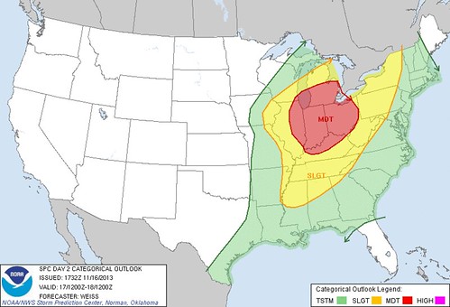
day 2 convective outlook
nws storm prediction center norman ok
1132 am cst sat nov 16 2013
valid 171200z - 181200z
...there is a mdt risk of svr tstms over parts of ern il...extreme
sern wi...srn lower mi...oh...indiana...and nrn ky...
...there is a slgt risk of svr tstms from the mid-south/tn valley
into the great lakes region...
...potential exists for a widespread damaging wind event and several
tornadoes /some possibly strong/ sunday afternoon and night across
parts of the oh valley and great lakes...
...synopsis...
longwave trough currently over the wrn us is forecast to intensify
through sunday as a very strong mid-level jet streak digs sewd
across the great basin and central rockies before progressing ewd
across the central plains/mid ms valley during the afternoon. the
upper trough is forecast to become negatively-tilted as it lifts
newd across the great lakes region during the second half of the
period.
at the surface...an intense deepening low is forecast to move from
ia toward ern lake superior during the day and progress into ern
ontario and wrn quebec at night. a strong cold front will arc swd
from the low with the nrn part of the front accelerating across the
great lakes region. the srn part of the front is expected to lag
swwd...reaching an ern lower mi/srn indiana/central ar/nrn tx line
by 18/00z...and ern ny/nrn va/wrn nc/nrn ga and lower ms valley by
the end of the period.
...oh valley into the srn great lakes...
overnight storms may be continuing from parts of the oh valley swwd
across the mid-south/tn valley in association with a weak shortwave
trough and low level warm advection. this activity may contain a
more limited severe threat for hail and strong/severe wind gusts as
it shifts ewd/newd with time. although dynamic forcing for large
scale ascent is expected to remain primarily north of this
area...sufficient deep layer shear will support organized storm
structures including potential for isolated supercells.
the primary severe threat is expected to develop during the late
morning into early/mid afternoon from ern ia into parts of
nrn/central il...then spread ewd through the overnight hours across
the great lakes and oh valley. strong sswly low level winds will
continue to advect moisture nwd toward the deepening surface low
with 60-65f dew points reaching as far north as nrn parts of il and
indiana. a plume of steeper mid level lapse rates is forecast to
extend ewd from the central plains toward the srn great lakes and
will contribute to increased instability with cape of 1000-1500 j/kg
forecast across parts of il and indiana. strong/severe storms may
develop as early as mid/late morning over parts of ern ia near the
surface low and advancing cold front...then increase in coverage
into nrn/central il during the afternoon as strong dynamic forcing
within the left exit region of the mid/upper level jet streak
overspreads the low level moisture/instability axis.
forecast soundings indicate development of clockwise turning
low-level hodograph structures in association with strong veering
wind profiles. several 12z convection-allowing models /especially
the 4 km wrf-nssl and 1.3 km nam fire nest/ indicate development of
supercells along/ahead of the cold front across parts of il/indiana
and srn lower mi along/ahead of the strongest ewd surge of the cold
front. these will have a window of opportunity from mid-late
afternoon into the early evening to produce swaths of damaging wind
gusts...severe hail and possibly several tornadoes /some strong/.
with time...convection is expected to develop into bowing linear
structures and spread rapidly ewd/newd across the lower great
lakes/upper oh valley with the primary severe threat transitioning
to potentially widespread damaging wind gusts. the fast-moving
lines will move progressively into lesser instability...however
vertical transfer of strong horizontal momentum to the surface may
maintain a threat for wind damage through much of the overnight
hours.
..weiss.. 11/16/2013
click to get wuus02 ptsdy2 product
note: the next day 2 outlook is scheduled by 0700z
page created: Nov 16, 2013 - 7:30 p.m. EST
Nov 16 JustaSooner's analysis

The two lines of storms is the concerning part. Obviously exact cell placement has a margin of error, so this can't be used as an actual guide of who gets hit and who doesn't. However, seeing a line of broken supercells on the back edge with the front but also isolated supercells ahead of that main line makes it pretty concerning. Anything that can start isolated ahead of the main line is what I would be most concerned about.
You can't read into what they are saying as the highest tornado risk will be west of Toledo. The highest tornado risk is going to be with any storm that can remain isolated and doesn't get undercut by outflow.
Widespread damaging winds will kick in once we see things line out. Could still see a few embedded rotations/quick spin ups, but later into the evening things go the lower the tornado threat - as it looks now. Don't try to read into it right now on too micro of a level.
posted by JustaSooner on Nov 16, 2013 at 01:51:31 pm
Highest tornado threat timeline tomorrow...
12PM - SW MI, Much of Indiana, S Illinois
3PM - SC MI, NW OH, Indiana, S IL, W KY, W TN
6PM - W OH (better dynamics may be near the TOL area where Ohio is concerned), S IN, Ohio River Valley in KY
Tornado threat should be down quit a bit after 7-8pm tomorrow.
Precip timing for NW OH...
4AM - Scattered showers NW OH
7AM - Light to moderate rain N OH
10AM - Isolated sprinkles otherwise dry
1PM - Mostly dry, maybe and isolated shower developing.
4PM - Severe Storms, heavy rain
7PM - Severe Storms, heavy rain
10PM - Storms, moderate rain ending
1AM - Dry
posted by JustaSooner on Nov 16, 2013 at 06:51:08 pm
Sat, Nov 16 Wind Advisory
Issued by the N. IN NWS office that includes Fulton and Henry counties. The Cleveland and Pontiac, MI offices have not issued any such statements.
Statement as of 9:03 PM CST on November 16, 2013
... Wind Advisory remains in effect from noon EST /11 am CST/ to
10 PM EST /9 PM CST/ Sunday...
Hazardous weather...
- southerly winds of 25 to 30 mph with gusts up to 50 mph
Sunday afternoon will turn westerly by Sunday evening.
- Higher gusts and significant wind damage will be possible
with any thunderstorms.
Impacts...
- scattered power outages possible.
- Winds strong enough to make driving difficult in open areas.
Precautionary/preparedness actions...
A Wind Advisory means that sustained winds of 30 mph... or gusts
over 45 mph are expected. Winds this strong can make driving
difficult... especially for high profile vehicles. Use extra
caution.
Nov 17 - A
THE SYNOPTIC SETUP FOR SUNDAY IS RATHER IMPRESSIVE AS STRONG UPPER
JET ROUNDS THE BASE OF THE UPPER TROUGH AND SENDS AN AMPLIFYING
SHORTWAVE EAST TOWARD THE MID MS VALLEY SUNDAY MORNING...AND THE
CENTRAL/SOUTHERN GREAT LAKES BY SUNDAY EVENING. SIG MOIST LATENT
HEAT RELEASE WITH A WIDE OPEN GULF OF MEXICO...IN TANDEM WITH STRONG
UPPER DIVERGENCE AS DEEP PV ANOMALY ACQUIRES A NEGATIVE TILT WILL
SUPPORT RAPID CYCLOGENESIS...WITH THE DEEPENING SFC LOW TRACKING
NORTHEAST FROM IOWA AT 12Z TO THE NORTHERN LAKES BY 00Z.
ASSOCIATED WARM FRONT LOOKS TO LIFT NORTH OF THE LOCAL AREA BY
LATE MORNING OR EARLY AFTERNOON WITH THE LOWER LAKES REGION
BECOMING ENTRENCHED IN SYSTEM WARM SECTOR FOR A TIME SUNDAY.
STRONG SYNOPTIC COLD FRONT WILL THEN ROLL EAST THROUGH WESTERN
AREAS EARLY/MID AFTN AND OUR OHIO COUNTIES LATE AFTN/EARLY EVE.
EXPECT SOME SFC HEATING AND MAINLY DRY CONDITIONS FOR A TIME AROUND
THE MIDDLE OF THE DAY IN WARM SECTOR.
CHANCES FOR A SEVERE WEATHER OUTBREAK SUNDAY AFTN/EARLY EVE CONTINUE
TO LOOK BETTER AND BETTER WITH EACH MODEL RUN. LATEST GUIDANCE HINTS
AT SOME POTENTIAL FOR A BROKEN LINE OF LOW TOPPED DISCRETE
SUPERCELLS TO DEVELOP WITHIN WARM SECTOR BY LATE MORNING OR EARLY
AFTN GIVEN POTENTIAL LOW LVL CONVERGENCE ALONG A PRE-FRONTAL TROUGH
FEATURE WITH NO CAP AS DEEP UVM PLUME OVERSPREADS THE REGION.
THIS WILL DEPEND ON DEGREE OF DESTABILIZATION WHICH REMAINS A
QUESTION MARK AT THIS FORECAST RANGE. ALL MODEL GUIDANCE DEVELOPS
A LINE OF CONVECTION ALONG THE PRIMARY COLD FRONT SUNDAY
AFTN...DEVELOPING OVER NORTHEAST ILLINOIS AND THEN MERGING INTO A
LEWP/QLCS/SQUALL LINE INTO WESTERN PORTIONS OF THE FA BY MID AFTN
AND EASTERN ZONES LATE AFTN/EARLY EVE. HOW SEVERE/WIDESPREAD THIS
CONVECTION ENDS UP WILL BE DEPENDENT ON HOW EFFICIENT THE
NORTHWARD ADVECTION OF INSTABILITY IS WITHIN THE WARM SECTOR.
EXPECTATIONS ARE THAT AT LEAST 700-1000 J/KG OF SBCAPE WILL BE
ATTAINABLE WITH SEVERAL MODELS SUGGESTING UP TO 1500 J/KG.
FLOW/SHEAR/LOW LVL HELICITY IS OFF THE CHARTS WITH A 120-130 KT
MID LEVEL JET MAX NOSING INTO THE AREA. THE EXPECTATION FOR
WEAK/MODERATE DESTABILIZATION AND SUCH A STRONG WIND FIELD (LINE
NORMAL 0-3 KM BULK SHEAR MAGNITUDES APPROACHING 50 KNOTS!) HINT AT
A POTENTIAL HIGH IMPACT SEVERE WX EVENT...WITH RIJ/BOWING SEGMENTS
AND STEEPENING LOW LVL LAPSE RATES AUGMENTING THE POTENTIAL FOR
DAMAGING WINDS AND MESOVORT TORNADOES. LOW LCL'S IN MOIST
ENVIRONMENT AND SLIGHT BACKING OF LOW LEVEL WINDS IN RESPONSE TO
PRESSURE FALLS ALSO SUGGEST AN ELEVATED RISK FOR TORNADOES WITH
0-1 KM SHEAR PUSHING 40 KNOTS. GIVEN THIS ADDED A TOR MENTION TO
THE GRIDS. STAY TUNED AS THIS HAS THE POTENTIAL TO BE A
SIGNIFICANT SVR WX/TORNADO OUTBREAK ACROSS THE LOWER LAKES AND
OHIO VALLEY. OTHERWISE...UNSEASONABLY MILD WITH ADVISORY LEVEL
WIND GUSTS POSSIBLE OUTSIDE OF CONVECTION SUN AFTN/EVE.
! posted by JustaSooner on Nov 17, 2013 at 12:44:15 am # +
Nov 17 - B
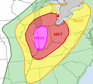
SPC issued its first Day 1 Convective Outlook for Sunday, November 17, 2013, and the SPC upgraded parts of the larger Moderate Risk area to be High Risk.
The High Risk is west of Ohio. The High Risk area includes most of Indiana and eastern Illinois.
The Toledo area, however, is still under the Moderate Risk.
High Risk statements are rarely issued by the SPC.
day 1 convective outlook
nws storm prediction center norman ok
1152 pm cst sat nov 16 2013
valid 171200z - 181200z
...there is a high risk of svr tstms across parts of ern il...ind
and far sw lower mi...
...there is a mdt risk of svr tstms across parts of il...lower
mi...oh...ind...ky and wrn tn......
...there is a slgt risk of svr tstms across parts of the mid to
upper ms valley...oh valley...srn great lakes and tn valley...
...tornado outbreak with multiple significant tornadoes and
widespread damaging winds expected across the oh valley and srn
great lakes region today...
an impressive negatively-tilted upper-level trough and powerful 80
to 100 kt mid-level jet will move across the ncntrl u.s. today. at
the sfc...a low will track newd into the upper midwest as a cold
front advances ewd into the mid to upper ms valley. ahead of the
front...strong moisture advection will occur due to a well-developed
and broad 60 to 75 kt low-level jet. an extensive area of
thunderstorms with an isolated severe threat should be ongoing along
the ern edge of the low-level jet from ne ar newd into srn ind at
daybreak with this activity moving ewd away from the instability
axis this morning. further to the west...the low-level jet will
transport low to mid 60s f sfc dewpoints into the mid ms valley and
oh valley resulting in a corridor of moderate instability from ne ar
nnewd into cntrl il by mid morning. due to strong large-scale ascent
associated with the upper-level trough...sfc-based cell initiation
should occur ahead of the front by mid morning across nrn and cntrl
il with storm coverage expanding ewd into ind and lower mi by early
afternoon. although cells may remain discrete through much of the
afternoon...the development of a squall-line appears likely during
the late afternoon across the oh valley with the line developing swd
into the tn valley during the early evening.
forecast soundings at urbana il and indianapolis ind in the 18z to
21z timeframe show sbcape near 1500 j/kg...0-6 km shear around 70
kt...low-lcl heights and long looped hodographs suggesting
supercells and tornadoes will be likely as discrete cells intensify.
0-3 km storm relative helicities of 400 to 450 m2/s2 will be
favorable for strong tornadoes with several long-track damaging
tornadoes expected to occur from ern il enewd across much of wrn and
cntrl ind from late morning into early afternoon. as cell coverage
increases ahead of the fast moving front...a squall-line should
organize late this afternoon. widespread wind damage will be
associated with the line along with tornadoes with rotating cells
embedded in the line. the severe threat should ramp up south of the
oh river during the late afternoon as cells initiate swd along the
front. the potential for wind damage and tornadoes should develop as
a far south as the tn valley during the evening as an extensive line
of severe storms moves ewd into the upper oh valley and cntrl
appalachian mtns.
several factors appear to be coming together for a tornado outbreak
across the oh valley. the first factor is that the system is
negatively-titled and very well-organized. the second is that the
low and mid-level jets will become favorably coupled in the oh
valley today coinciding with an outbreak of storms across the warm
sector. the third is that supercells are expected to remain discrete
into the mid-afternoon. these factors combined with extremely
favorable low-level shear profiles justifies the issuance of a high
risk across ern il...ind and sw lower mi.
..broyles/bunting.. 11/17/2013
click to get wuus01 ptsdy1 product
note: the next day 1 outlook is scheduled by 1300z
Nov 17 - c
(my early morning comment at TT)
JustaSooner has updated the post that started this thread with the latest info from the Storm Prediction Center.
Here are some snippets, which are based upon the SPC's outlook that was issued at 12:52 a.m. EST on Sun, Nov 17, 2013.
SPC text and image info:
http://www.spc.noaa.gov/products/outlook/day1otlk.html
Excerpts:
tornado outbreak with multiple significant tornadoes and widespread damaging winds expected across the oh valley and srn great lakes region today
several factors appear to be coming together for a tornado outbreak across the oh valley. the first factor is that the system is negatively-titled and very well-organized. the second is that the low and mid-level jets will become favorably coupled in the oh valley today coinciding with an outbreak of storms across the warm sector. the third is that supercells are expected to remain discrete into the mid-afternoon. these factors combined with extremely favorable low-level shear profiles justifies the issuance of a high risk across ern il...ind and sw lower mi.
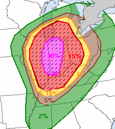
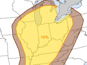
Risk for severe weather, which includes the rarely-issued High Risk area.
Probability of damaging thunderstorm winds or wind gusts of 50 knots or higher within 25 miles of a point.
Hatched Area: 10% or greater probability of wind gusts 65 knots or greater within 25 miles of a point.
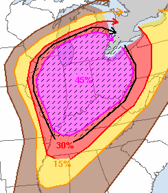
Probability of a tornado within 25 miles of a point.
Hatched Area: 10% or greater probability of EF2 - EF5 tornadoes within 25 miles of a point.
Probability of one inch diameter hail or larger within 25 miles of a point.
Hatched Area: 10% or greater probability of two inch diameter hail or larger within 25 miles of a point.
Past notes about severe weather:
Moderate Risk
Typically, the SPC does not misfire on its prediction for severe weather when a moderate risk is issued. It's usually a rough time in or near the moderate risk areas.
It's a bit uncommon to have a moderate risk issued for northwest Ohio and/or southeast Michigan. Such a forecast may not happen every year for our region.
This is the second time in 2013 that the Toledo area has landed under a Moderate Risk for severe weather.
The previous time occurred on June 12, 2013. On that day, the severe weather occurred in northern Indiana and north central and northeast Ohio. It missed the immediate Toledo area.
High Risk
What's really rare anywhere in the U.S. is for the SPC to issue a High Risk forecast for severe weather as indicated by magenta-colored legend in the above image.
Back on June 12, 2013, the SPC issued a High Risk for northern Illinois, northern Indiana, and extreme northwest Ohio.
June 12, 2013 comment by JustaSooner :
As someone may ask...all watches in the high risk today will be PDS watches. So we'll see our first PDS Severe in probably 2 years.
June 13, 2013 comment by JustaSooner :
PDS = Particularly Dangerous Situation. It is the highest level of a watch box and they are very rare. They will only be issued when conditions are in place for a widespread, high end event. Sometimes they do bust but that is because high end situations are extremely volatile and if one ingredient is off it can keep things from happening.
So some tornado watches are considered worse than others. Not all get the PDS status.
Could a PDS-type watch be issued on Sunday?
Some basic info:
Watches
Remember, the SPC issues Severe Thunderstorm Watches and Tornado watches. These watch-boxes are issued for large regions that include many counties. And they are usually issued for a six-hour period, but that can vary. The watch means the likelihood exists that severe thunderstorms or tornadoes could occur in the watch box.
Warnings
Severe Thunderstorm Warnings and Tornado Warnings are issued by the regional National Weather Service. The warnings can be issued for an entire county or for only a portion of a county. And the warnings usually exist for 60 minutes. Obviously, the warnings mean severe weather is imminent for the warned area.
National Weather Service Offices
JustaSooner has mentioned in the past about how Toledo is in an unfortunate black hole, regarding radar and National Weather Service coverage.
Three different National Weather Service offices issue forecasts, warnings, and advisories for the immediate Toledo area.
The Detroit/Pontiac NWS covers Monroe and Lenawee counties.
The northern Inidana NWS covers Fulton and Henry counties.
The Cleveland NWS covers Lucas, Wood, and Ottawa counties.
Toledo is at the very edge of coverage for all three offices.
Sirens
If Sunday's weather gets to be tornado-like in the Toledo area, do not rely on the sirens to inform you.
As we learned in June 2010, the tornado sirens are NOT designed to be heard by people inside a home or a building with the TV, stereo, vacuum cleaner, or air conditioner running.
The sirens are meant to warn people who are outside.
Some sirens will malfunction.
The sheriff's office is charged with sounding the sirens. The sheriff is suppose to sound the siren if the county is under a tornado warning.
But we also learned in June 2010, that the sheriff can sound the siren at his or her own discretion, depending upon the severity of the advancing weather. The sheriff does not have to wait for NWS to issue a tornado warning for the county.
The NWS could issue a tornado warning for only a portion of a county. But when the sirens sound, I think they sound throughout the entire county.
I understand that the local TV media will probably interrupt normal Sunday afternoon/evening broadcasts (NFL) because of the weather, but it might be a good idea, at least for those people who do not have Internet access.
The storms will probably move through very fast, so you won't have the normal amount of lag time between the moment your dog first detects thunder and when the storm actually hits.
And even if we do not get any severe weather, we'll still have some strong November winds on Sunday and especially Sunday night. With the leaves down, that means we'll hear the low, howling, growling, rumbling wind blow through the big oak trees in our neighborhood. That's always an eerie sound, especially at night.
Hopefully, we won't need this: First Energy Power Outage Map
And if anyone plans to do any kayaking on Lake Erie on Sunday night or Monday in the central and eastern basins, here's the near shore marine forecast:
gale warning in effect from sunday evening through monday
afternoon
sunday night... south gales to 35 knots becoming west gales to 40 knots. showers and thunderstorms in the evening. waves 3 to 5 feet building to 11 to 15 feet.
monday... west gales to 40 knots decreasing to 35 knots. mostly cloudy with a chance of rain showers. waves 12 to 16 feet.
Nov 17 - d
Toledo Express Airport Weather
Nov 17, 2013 2:52 am
Weather : Mostly Cloudy
Temperature : 57 F
Humidity : 90%
Wind Speed : S 9 mph - Gust 20 mph
Barometer : 29.76 in
Dewpoint: 54 F
Visibility : 10.00 statute miles
Toledo 7-day forecast
Last Update: Nov 16, 2013 9:39 pm
Overnight: Showers and possibly a thunderstorm. Low around 54. Breezy, with a south wind around 20 mph. Chance of precipitation is 100%. New rainfall amounts between a tenth and quarter of an inch, except higher amounts possible in thunderstorms.
Sunday: Showers and possibly a thunderstorm before 1pm, then a chance of showers and thunderstorms between 1pm and 4pm, then showers likely and possibly a thunderstorm after 4pm. Some storms could be severe, with damaging winds. High near 67. Windy, with a south wind 17 to 22 mph increasing to 24 to 29 mph in the afternoon. Winds could gust as high as 46 mph. Chance of precipitation is 80%. New rainfall amounts between a quarter and half of an inch possible.
Sunday Night: Showers and thunderstorms before 1am, then a slight chance of showers between 1am and 4am. Some storms could be severe, with damaging winds. Low around 43. Windy, with a west wind 21 to 29 mph, with gusts as high as 44 mph. Chance of precipitation is 90%. New rainfall amounts between a tenth and quarter of an inch, except higher amounts possible in thunderstorms.
Monday: Partly sunny, with a high near 48. Breezy, with a west wind 18 to 22 mph.
Monday Night: Partly cloudy, with a low around 30. West wind 6 to 14 mph.
Tuesday: Sunny, with a high near 44.
Tuesday Night: Mostly clear, with a low around 26.
Wednesday: Mostly sunny, with a high near 43.
Nov 17 - e
hazardous weather outlook
national weather service cleveland oh
346 am est sun nov 17 2013
ohz003-006-008>013-017>023-027>033-036>038-047-180900-
lucas-wood-sandusky-erie oh-lorain-cuyahoga-lake-geauga-hancock-
seneca-huron-medina-summit-portage-trumbull-wyandot-crawford-
richland-ashland-wayne-stark-mahoning-marion-morrow-holmes-knox-
346 am est sun nov 17 2013
...wind advisory in effect from 7 pm this evening to 7 am est
monday...
this hazardous weather outlook is for north central
ohio...northeast ohio and northwest ohio.
.day one...today and tonight.
please listen to noaa weather radio or go to weather.gov on the
internet for more information about the following hazards.
wind advisory.
the storm prediction center has indicated that there is a
moderate risk for severe thunderstorms today and tonight. a
squall line is expected to develop and move across the local area
late this afternoon and evening. very strong winds are expected
just off the surface. heavy rain from the squall line could bring
these strong winds down to the surface causing widespread damage.
this is a very dangerous situation. isolated tornadoes will also
be possible.
.days two through seven...monday through saturday.
please listen to noaa weather radio or go to weather.gov on the
internet for more information about the following hazards.
wind advisory.
.spotter information statement...
spotter activation will likely be needed.
Nov 17 - f
fxus61 kcle 171142
afdcle
area forecast discussion
national weather service cleveland oh
642 am est sun nov 17 2013
synopsis...
a doubled barreled low pressure from southern minnesota to western
kansas will move to northern lake michigan by this evening.
meanwhile...the low pressure will deepen rapidly as it moves into
west central quebec by monday afternoon. a strong cold front will
sweep east across the area tonight. high pressure will move east out
of the southern plains states into the ohio valley by tuesday and
then off the east coast on wednesday.
&&
near term /until 6 pm this evening/...
showers continue to move east and out of the area at this time.
cellular convection continues to move into extreme northwest ohio
and southern lower michigan. the water vapor plume is also pushing
east allowing for some drier air to move east and allow for a
break in the action. latest hrrr model shows massive squall line
developing over illinois and rapidly intensifies as it moves east
toward ohio. timing would put the line at toledo and findlay at
22z and to cleveland and mansfield by about 00z and finally to
erie and youngstown by 02z or so. so the wait begins. stay tuned.
previous discussion...
the long anticipated severe weather threat day has arrived. two low
pressure systems in the upper midwest are beginning to merge and
intensify this morning.
southerly flow has increased across the forecast area and this will
be the beginning of the strengthening wind flow throughout the day.
moderately strong low level jet will remain persistent over the
forecast area today and with the warm air advection...some of the
stronger winds will mix down to the surface. so...will go ahead and
issue a wind advisory for the entire area but will be for mainly
later this evening into tonight since the strongest winds will take
place after the cold frontal passage.
60 to 70 knot speed maximum at 850 mb will pose a problem as
convection develops later this morning into the afternoon hours. the
stronger winds could be forced to the surface in the thunderstorms
and produce widespread wind damage. latest storm prediction center
outlook continues to highlight a moderate risk for severe
thunderstorms across the area today. there is a high risk just west
of the forecast area.
even though the main threats will be the strong damaging
winds...latest model sounding hodographs indicate some fairly high
levels of helicity...especially across areas from cleveland to akron
canton west. i cant rule out the potential for any thunderstorms
that develop that they could begin to rotate rather quickly and
produce tornadoes. temperature dew point spreads are progged to be
at or below the 5 degree threshold and this is one key ingredient
for tornadoes to develop.
looking at the latest water vapor imagery shows an extensive area of
moisture streaming north across the forecast area at this time.
however...just west of the area...this moisture plume diminishes and
this is resulting in clearing skies well ahead of the cold front.
with this in mind...i am concerned that we will see a lot more sun
than i currently have in the forecast. if this is the case...then
current forecast temperatures could be too low and therefore will
see even greater instability develop. this will have to be watched
closely today.
&&
short term /6 pm this evening through wednesday night/...
the severe weather threat will not be over tonight. the cold front
and potential squall line is expected to move through the area this
evening and this is when we have the highest threat for widespread
wind damage. one factor is we will be losing the day time heating
and this may help to stabilize things a bit.
as the cold front shifts east...cold air advection will take place
and allow winds to mix down to the surface. will hoist a wind
advisory for tonight due to the post frontal winds expected.
as the strong low pressure system moves rather quickly to the
northeast...winds are expected to diminish fairly quickly monday
into tuesday.
cyclonic flow around the back side of the low and in advance of the
next high pressure will cause showers to continue over the extreme
northeast portion of the forecast area. otherwise...drier air will
begin to return back to the region on monday. the cold air advection
will likely produce some lake effect rain and snow showers over the
northeast monday night and tuesday. the high will build in across
the ohio valley and shift the flow away from the lake ending the
lake effect threat. otherwise...fair weather is expected across the
rest of the forecast area monday into tuesday and over all areas
tuesday night through wednesday night.
the cold front will result in cold air advection and plunge
temperatures back to near normal in the 40s for highs and overnight
lows in the 20s to lower 30s.
&&
long term /thursday through saturday/...
not many changes to the long term today. the new guidance continues
to show the possibility of warm air advection showers on
thursday...especially in the west. unsettled weather will then
continue into next weekend as a series of frontal systems affects
the region. it appears best chances for precip will be friday night
into saturday as a wave moves across the ohio valley. most of the
precip should be liquid although mixed rain and snow could occur
early saturday. temps during the period will be seasonable and have
stayed fairly close to guidance.
&&
aviation /12z sunday through thursday/...
a large area of showers remains over the eastern half of the area
this morning and is expected to exit to the east in a couple of
hours. most locations remain vfr but some patchy mvfr is being
reported. a lot of mvfr cigs to the west and expect all areas to
dip to mvfr cigs by midday. shower activity to the west of the
main area will be scattered in nature this morning. expect much of
the afternoon to be dry with a few peaks of sunshine possible. new
guidance coming in continues to show a squall line developing
over nw oh toward evening. confidence in this scenario is
unusually high. this line should reach ktol and kfdy around sunset
and is then expected to race east across the remainder of the area
this evening. the line could move as fast as 45 to 50 knots at
times. very strong winds are forecast just above the surface and
any significant rain will bring these strong winds down to the
surface. as a result have continued to hit the winds pretty hard
in the new forecast. a cold front will follow the squall line
across the area this evening and expect cigs to lift to vfr and
then dissipate from west to east overnight. winds today will be
mainly from the south with gusts increasing to 35 knots this
afternoon. the flow behind the front will be wsw and gusts could
get to 40 knots overnight.
outlook...non-vfr conditions will continue sunday night into
monday with a few shra. a few shsn monday night...mainly across ne
oh/nw pa. conditions improving to vfr from west to east tuesday.
&&
marine...
no changes to the headlines on the lake today. the gale still looks
good for late today and tonight. still expecting a squall line to
move across the lake this evening and wind gusts could approach 50
knots. winds will become westerly behind the cold front responsible
for the squall line. speeds should gradually diminish on monday and
expect a prolonged period of small craft advisories once the gale
comes down. local guidance also shows water levels making a run for
the critical mark late tonight. will see how things develop but
later shifts may need to go with a low water advisory. the flow
will become nw on monday as high pressure begins to build in from
the west. a surface ridge will eventually move east of the lake
tuesday night allowing the flow to become southerly. south to
southwest flow will then continue till a cold front crosses the lake
at the very end of the period.
&&
cle watches/warnings/advisories...
oh...wind advisory from 7 pm this evening to 7 am est monday for
ohz003-006>014-017>023-027>033-036>038-047-089.
pa...wind advisory from 7 pm this evening to 7 am est monday for
paz001>003.
marine...gale warning from 6 pm this evening to 4 pm est monday for
lez061-142>149-162>169.
&&
$$
synopsis...lombardy
near term...lombardy
short term...lombardy
long term...kubina
aviation...kubina
marine...kubina
Nov 17 - g
PUBLIC SEVERE WEATHER OUTLOOK
NWS STORM PREDICTION CENTER NORMAN OK
0249 AM CST SUN NOV 17 2013
...SEVERE THUNDERSTORMS EXPECTED OVER PARTS OF THE MID-MISSISSIPPI
AND OHIO VALLEYS INTO MICHIGAN TODAY THROUGH EARLY TONIGHT...
The NWS Storm Prediction Center in Norman, Oklahoma is forecasting
the development of a few strong, long-track tornadoes over parts of
the Mid-Mississippi and Ohio Valleys into Michigan today through
early tonight.
The areas most likely to experience this activity include:
Illinois
Indiana
Northern and Western Kentucky
Lower Michigan
Ohio
Southeast Wisconsin
Surrounding this greatest risk region, severe thunderstorms will
also be possible from parts of Wisconsin, Iowa, Missouri, Arkansas,
Mississippi, Alabama, and Tennessee northeastward across much of the
Appalachians to the lower Great Lakes.
A potent jet stream disturbance with wind speeds in excess of 120
knots will sweep east across the central Plains today and across the
Ohio Valley and northern half of the Appalachians tonight. As this
occurs, a surface low now over the mid-Mississippi Valley will
rapidly intensify and accelerate northeastward, reaching northern
Michigan early tonight and western Quebec Monday morning.
East of the low, increasingly warm and humid air at the surface will
spread north across the Tennessee and Ohio Valleys, contributing to
very unstable conditions over a large part of the east central
United States. Coupled with daytime heating and ascent provided the
jet stream impulse, the environment will become very favorable for
severe thunderstorms --- especially along and ahead of fast-moving
cold front trailing southward from the low into the mid-Mississippi
and Ohio Valleys.
Given the degree of thermodynamic instability, and the strength and
character of the winds through the depth of the atmosphere, many of
the storms will become supercells. Some of these will be capable of
producing strong tornadoes --- in addition to large hail and swaths
of damaging surface winds.
The storms are expected to consolidate into one or two extensive
lines later today into tonight --- extending the threat for damaging
winds and isolated tornadoes eastward into the Appalachians by early
Monday.
State and local emergency managers are monitoring this potentially
very dangerous situation. Those in the threatened area are urged to
review severe weather safety rules and to listen to radio,
television, and NOAA Weather Radio for possible watches, warnings,
and statements later today.
Nov 17 - h
md 2011 concerning severe potential...tornado watch likely for ind...cntrl/srn lower mi...nwrn oh
mesoscale discussion 2011
nws storm prediction center norman ok
1001 am cst sun nov 17 2013
areas affected...ind...cntrl/srn lower mi...nwrn oh
concerning...severe potential...tornado watch likely
valid 171601z - 171800z
probability of watch issuance...95 percent
summary...significant tornado/wind hazards will increase rapidly
midday into afternoon with a downstream tornado watch issuance
expected e of ww 561.
discussion...recent storm development has occurred across e-cntrl il
just ne of mto. although downstream surface heating has been
hampered by abundant stratus...low-level moist advection and
steepening lapse rates aloft should yield increasing
destabilization. very strong wind profiles may result in a few
supercells forming well ahead of the main swath of large-scale
ascent and widespread convection farther west in sern wi and nrn/wrn
il. with time...this activity will also spread rapidly e/newd with
corresponding risks for significant tornadoes/wind.
..grams/mead.. 11/17/2013
...please see www.spc.noaa.gov for graphic product...
attn...wfo...iln...dtx...apx...iwx...grr...ind...lot...
lat...lon 44168638 44218520 43948421 43148375 40788406 39238535
38968669 39108754 40128748 41748704 44168638
Nov 17 - i
High Wind Warning
Statement as of 10:29 AM EST on November 17, 2013
... High Wind Warning in effect from 5 PM this afternoon to 5 am
EST Monday...
The National Weather Service in Detroit/Pontiac has issued a High
Wind Warning... which is in effect from 5 PM this afternoon to
5 am EST Monday. The high wind watch is no longer in effect.
Hazardous weather...
- southwest winds of 30 to 40 mph with gusts over 55 mph will
develop this evening. Winds will turn westerly early tomorrow
morning and decrease to 25 to 35 mph. However... wind gusts
around 45 mph are likely into Monday.
Impacts...
- tree damage is expected leading to downed power lines and numerous
power outages.
- Weak structures like old barns and sheds will be susceptible
to being blown down.
- Travel on north-south roads will become hazardous in the
strong winds especially for high profile vehicles.
- Precautionary/preparedness actions...
- a High Wind Warning means a hazardous high wind event is
expected or occurring. Sustained wind speeds of at least 40 mph
or gusts of 58 mph or more can lead to property damage.
- Prepare... plan... and stay informed. Visit
http://go.USA.Gov/rr8
Nov 17 - j
Tornado watch until 8:00 p.m. that includes the counties of Monroe, Henry, and Fulton.
Nov 17 - k
High Wind Warning
Statement as of 3:08 AM CST on November 17, 2013
... High Wind Warning in effect from 1 PM EST /noon CST/ this
afternoon to 1 am EST /midnight CST/ Monday...
The National Weather Service in northern Indiana has issued a
High Wind Warning... which is in effect from 1 PM EST /noon CST/
this afternoon to 1 am EST /midnight CST/ Monday. The Wind
Advisory is no longer in effect.
Hazardous weather...
- southerly winds of 25 to 30 mph with gusts up to 45 mph will
shift to west with gusts up to 60 mph this afternoon and this
evening.
- Higher gusts and significant wind damage will also be possible
with thunderstorms moving through the area today.
Impacts...
- power outages possible.
- Damage to trees possible.
- Driving will be difficult... especially for high profile
vehicles such as semi-trucks.
Precautionary/preparedness actions...
A High Wind Warning means a hazardous high wind event is expected
or occurring. Sustained wind speeds of at least 40 mph or gusts
of 58 mph or more can lead to property damage.
Nov 17 - l
Particularly Dangerous Situation (PDS) Tornado Watch 562
http://www.spc.noaa.gov/products/watch/ww0562.html
URGENT - IMMEDIATE BROADCAST REQUESTED
TORNADO WATCH NUMBER 562
NWS STORM PREDICTION CENTER NORMAN OK
1120 AM EST SUN NOV 17 2013
THE NWS STORM PREDICTION CENTER HAS ISSUED A
* TORNADO WATCH FOR PORTIONS OF
INDIANA
FAR NORTHERN KENTUCKY
LOWER MICHIGAN
WESTERN OHIO
LAKE HURON
LAKE MICHIGAN
* EFFECTIVE THIS SUNDAY MORNING AND EVENING FROM 1120 AM UNTIL
800 PM EST.
...THIS IS A PARTICULARLY DANGEROUS SITUATION...
* PRIMARY THREATS INCLUDE...
SEVERAL INTENSE TORNADOES LIKELY
NUMEROUS DAMAGING WIND GUSTS LIKELY WITH SEVERAL SIGNIFICANT
GUSTS TO 80 MPH POSSIBLE
SEVERAL LARGE HAIL EVENTS TO 1.5 INCHES IN DIAMETER LIKELY
THE TORNADO WATCH AREA IS APPROXIMATELY ALONG AND 90 STATUTE
MILES EAST AND WEST OF A LINE FROM 40 MILES SOUTHEAST OF
BLOOMINGTON INDIANA TO 55 MILES NORTHWEST OF SAGINAW MICHIGAN.
FOR A COMPLETE DEPICTION OF THE WATCH SEE THE ASSOCIATED WATCH
OUTLINE UPDATE (WOUS64 KWNS WOU2).
PRECAUTIONARY/PREPAREDNESS ACTIONS...
REMEMBER...A TORNADO WATCH MEANS CONDITIONS ARE FAVORABLE FOR
TORNADOES AND SEVERE THUNDERSTORMS IN AND CLOSE TO THE WATCH
AREA. PERSONS IN THESE AREAS SHOULD BE ON THE LOOKOUT FOR
THREATENING WEATHER CONDITIONS AND LISTEN FOR LATER STATEMENTS
AND POSSIBLE WARNINGS.
&&
OTHER WATCH INFORMATION...CONTINUE...WW 561...
DISCUSSION...THUNDERSTORMS RAPIDLY DEVELOPING OVER IL AND WI ARE
EXPECTED TO SPREAD EAST/NORTHEAST ACROSS THE WATCH AREA TODAY IN
CONJUNCTION WITH AN INTENSE LARGE-SCALE WEATHER SYSTEM. GIVEN THE
COMBINATION OF MODERATE INSTABILITY AND VERY STRONG VERTICAL
SHEAR...SUPERCELLS AND BOWING STRUCTURES APPEAR LIKELY WITH A RISK
FOR LONG-TRACKED...SIGNIFICANT TORNADOES...CORRIDORS OF WIND DAMAGE
AND LARGE HAIL.
AVIATION...TORNADOES AND A FEW SEVERE THUNDERSTORMS WITH HAIL
SURFACE AND ALOFT TO 1.5 INCHES. EXTREME TURBULENCE AND SURFACE
WIND GUSTS TO 70 KNOTS. A FEW CUMULONIMBI WITH MAXIMUM TOPS TO
500. MEAN STORM MOTION VECTOR 24055.
Nov 17 - m
High Risk area expanded to includes parts of extreme northwest Ohio.
spc ac 171629
day 1 convective outlook
nws storm prediction center norman ok
1029 am cst sun nov 17 2013
valid 171630z - 181200z
...there is a high risk of svr tstms today across parts of
illinois...indiana...western ohio and southern lower michigan...
...there is a mdt risk of svr tstms surrounding the high risk
area...parts of eastern missouri and much of kentucky northeastward
into the lower great lakes region...
...there is a slgt risk of svr tstms surrounding the moderate risk
area...across the remainder of lower/middle mississippi valley
northeastward through the mid atlantic states and western new
england...
an outbreak of severe storms now appears underway across parts of
the middle mississippi valley into parts of the upper great lakes
region. this will progress eastward through much of the remainder
of the great lakes region and ohio valley...perhaps parts of the
tennessee and lower mississippi valleys...into parts of the
northeast by late tonight. a few strong tornadoes are
expected...mainly across parts of the lower ohio valley into great
lakes this afternoon. otherwise...widespread strong damaging winds
appear likely with an evolving squall line.
...mid ms/lwr oh valleys thru the lwr great lakes and northeast...
the only substantive change to the 13z outlook was to begin to trim
away at the western edge of categorical/probabilistic lines...where
frontal passage is diminishing convective potential. strong
post-frontal surface pressure rises are advancing eastward across
missouri/southern iowa and will likely reach the vicinity of the
mississippi river within the next hour or two.
the deep surface cyclone from which the front trails is forecast to
rapidly deepen as it migrates north northeastward across the lake
michigan area this afternoon...into eastern ontario tonight.
this is expected to occur as a 100+ kt westerly 500 mb jet streak
noses eastward into and through the ohio valley. mid-level forcing
for upward vertical motion and cooling in the exit region of this
feature appears likely to be the primary focus for destabilization
and strongest thunderstorm development today through tonight.
the warm sector environment across eastern missouri into illinois
appears very conducive to severe storm development...with convective
development now already well underway. this is generally on the
leading edge of higher moisture content air /lower to mid 60s
surface dew points/ returning off the gulf of mexico...where
steepening mid-level lapse rates are enhancing convective
instability and cape. a window of opportunity appears to exist for
discrete supercell development into mid to late afternoon across
eastern illinois and indiana...southern lower michigan/western ohio
and adjacent portions of the ohio valley and great lakes
region...before forcing along the eastward surging cold front
contributes to an upscale growing squall line. given the 50-60+ kt
westerly deep layer mean flow...storm motions will be rapid. large
clockwise curved low-level hodographs will also be conducive to the
potential for strong tornadoes...some of which could be relatively
long-lived/long track.
due to leading precipitation and cloud cover...boundary layer
destabilization eastward into the lower great lakes region and upper
ohio valley becomes more unclear...with stronger mid-level cooling
also likely to begin to be outrun by the surface cold front.
however...frontal forcing should be sufficient to maintain at least
a narrow squall line...and thermodynamic profiles likely will remain
favorable for lightning into and through the overnight
hours...probably as far east as western/southern new england and the
northern mid atlantic coast region by 12z monday.
as southerly 850 mb flow strengthens to 50-70 kt along/ahead of the
eastward advancing front across the ohio valley this
afternoon...precipitation loading will contribute to the downward
transfer of higher momentum to the surface. potentially
damaging...convectively enhanced wind gusts may become widespread
along the progressive squall line...at least as far east as the
lower great lakes and northern/central appalachians region by late
evening. the impact of a potential residual cool/stable near
surface layer on severe potential overnight across the northeast is
unclear...but a continuing risk for damaging wind gusts with the
enhanced convective band certainly does not appear out of the
question.
..kerr/cohen.. 11/17/2013
click to get wuus01 ptsdy1 product
note: the next day 1 outlook is scheduled by 2000z
Nov 17 - n
MESOSCALE DISCUSSION 2013
NWS STORM PREDICTION CENTER NORMAN OK
1049 AM CST SUN NOV 17 2013
AREAS AFFECTED...IL...SERN WI...E-CNTRL MO
CONCERNING...TORNADO WATCH 561...
VALID 171649Z - 171815Z
THE SEVERE WEATHER THREAT FOR TORNADO WATCH 561 CONTINUES.
SUMMARY...RISK FOR SIGNIFICANT AND POTENTIALLY LONG-TRACK TORNADOES
APPEARS TO BE INCREASING...ESPECIALLY ACROSS PARTS OF CNTRL/ERN IL.
DISCUSSION...NUMEROUS PRE-FRONTAL STORMS HAVE FORMED FROM NEAR
MILWAUKEE S/SWWD TOWARDS ST LOUIS. 16Z ILX RAOB WELL-SAMPLED THE
AMBIENT WARM SECTOR...DEPICTING MODERATE BUOYANCY DESPITE A SLIGHT
INVERSION NOTED NEAR 600 MB. LOW-LEVEL HODOGRAPHS HAVE BECOME EVEN
LARGER IN LATEST VWP DATA FROM ILX WITH A CLASSIC SICKLE-SHAPE AND
0-1 KM SRH AROUND 500 M2/S2. POTENTIAL IS HIGH FOR SEVERAL
SUPERCELLS AND GIVEN RAPID STORM MOTIONS...A FEW SHOULD BE
LONG-TRACKED ACROSS THE HEART OF IL WITH SIGNIFICANT TORNADOES.
Nov 17 - 1225
(maintaining a summary page at TT.)
updated at 12:18 p.m., Sun, Nov 17, 2013
Multiple tornado and severe thunderstorm warnings are in effect in southeast Wisconsin and scattered throughout Illinois.
If storms do occur in northwest Ohio today, they will move very fast to the northeast at 50 to 60 mph. The air drag from storms moving at such a high rate of speed will cause strong winds at the surface.
Some supercell development is expected today.
At Noon, the only issue up for Lucas County is a Wind Advisory.
A High Wind Warning exists for Fulton and Henry counties from 1:00 p.m. to 1:00 a.m.
A High Wind Warning exists for Lenawee and Monroe counties from 5:00 a.m. to 5:00 p.m.
A Tornado Watch exists for Lenawee, Monroe, Fulton, and Henry counties until 8:00 p.m.
JustaSooner comment at TT made at 9:38 a.m. today:
- First wave of storms will be in the I-75 Corridor by 4PM.
- Main squall line will be moving through 7-8PM.
About the High Wind Warning that includes Fulton County:
- southerly winds of 25 to 30 mph with gusts up to 45 mph will
shift to west with gusts up to 60 mph this afternoon and this
evening. - Higher gusts and significant wind damage will also be
possible with thunderstorms moving through the area today.
Nov 17 - 1226
fxus61 kcle 171533
afdcle
area forecast discussion
national weather service cleveland oh
1033 am est sun nov 17 2013
synopsis...
low pressure over the plains states will deepen rapidly as it
moves northeast today reaching northern lake michigan by this
evening and into quebec on monday. this will push a strong cold
front across the area this evening. high pressure will move east
out of the southern plains states into the ohio valley by tuesday
and then off the east coast on wednesday.
&&
near term /until 6 pm this evening/...
removed thunder across north central ohio and points east until
very late afternoon/evening. while i cannot rule out thunder...
would like to make the thunder and wind with the front more of the
focal point of the forecast. tough to do in these days of
automated text formatters...so not sure exactly what the wording
will say. better chance for thunder at any time in the dry slot
that is creeping across northwest ohio. sort of looks like
oklahoma in the spring time...hmmm.
no other significant changes to the forecast. did nudge up high
temperatures a couple of degrees across nw ohio and parts of north
central ohio where there will not be as many showers. record high
in toledo is 71 and we will take a run at it. 72 at cle is
potentially within reach.
relevant early morning updated discussion...
showers continue to move east and out of the area at this time.
cellular convection continues to move into extreme northwest ohio
and southern lower michigan. the water vapor plume is also pushing
east allowing for some drier air to move east and allow for a
break in the action. latest hrrr model shows massive squall line
developing over illinois and rapidly intensifies as it moves east
toward ohio. timing would put the line at toledo and findlay at
22z and to cleveland and mansfield by about 00z and finally to
erie and youngstown by 02z or so. so the wait begins. stay tuned.
previous discussion...
the long anticipated severe weather threat day has arrived. two low
pressure systems in the upper midwest are beginning to merge and
intensify this morning.
southerly flow has increased across the forecast area and this will
be the beginning of the strengthening wind flow throughout the day.
moderately strong low level jet will remain persistent over the
forecast area today and with the warm air advection...some of the
stronger winds will mix down to the surface. so...will go ahead and
issue a wind advisory for the entire area but will be for mainly
later this evening into tonight since the strongest winds will take
place after the cold frontal passage.
60 to 70 knot speed maximum at 850 mb will pose a problem as
convection develops later this morning into the afternoon hours. the
stronger winds could be forced to the surface in the thunderstorms
and produce widespread wind damage. latest storm prediction center
outlook continues to highlight a moderate risk for severe
thunderstorms across the area today. there is a high risk just west
of the forecast area.
even though the main threats will be the strong damaging
winds...latest model sounding hodographs indicate some fairly high
levels of helicity...especially across areas from cleveland to akron
canton west. i cant rule out the potential for any thunderstorms
that develop that they could begin to rotate rather quickly and
produce tornadoes. temperature dew point spreads are progged to be
at or below the 5 degree threshold and this is one key ingredient
for tornadoes to develop.
&&
short term /6 pm this evening through wednesday night/...
the severe weather threat will not be over tonight. the cold front
and potential squall line is expected to move through the area this
evening and this is when we have the highest threat for widespread
wind damage. one factor is we will be losing the day time heating
and this may help to stabilize things a bit.
as the cold front shifts east...cold air advection will take place
and allow winds to mix down to the surface. will hoist a wind
advisory for tonight due to the post frontal winds expected.
as the strong low pressure system moves rather quickly to the
northeast...winds are expected to diminish fairly quickly monday
into tuesday.
cyclonic flow around the back side of the low and in advance of the
next high pressure will cause showers to continue over the extreme
northeast portion of the forecast area. otherwise...drier air will
begin to return back to the region on monday. the cold air advection
will likely produce some lake effect rain and snow showers over the
northeast monday night and tuesday. the high will build in across
the ohio valley and shift the flow away from the lake ending the
lake effect threat. otherwise...fair weather is expected across the
rest of the forecast area monday into tuesday and over all areas
tuesday night through wednesday night.
the cold front will result in cold air advection and plunge
temperatures back to near normal in the 40s for highs and overnight
lows in the 20s to lower 30s.
&&
long term /thursday through saturday/...
not many changes to the long term today. the new guidance continues
to show the possibility of warm air advection showers on
thursday...especially in the west. unsettled weather will then
continue into next weekend as a series of frontal systems affects
the region. it appears best chances for precip will be friday night
into saturday as a wave moves across the ohio valley. most of the
precip should be liquid although mixed rain and snow could occur
early saturday. temps during the period will be seasonable and have
stayed fairly close to guidance.
&&
aviation /15z sunday through thursday/...
a large area of showers remains over the eastern half of the area
this morning and is expected to exit to the east in a couple of
hours. most locations remain vfr but some patchy mvfr is being
reported. a lot of mvfr cigs to the west and expect all areas to
dip to mvfr cigs by midday. shower activity to the west of the
main area will be scattered in nature this morning. expect much of
the afternoon to be dry with a few peaks of sunshine possible. new
guidance coming in continues to show a squall line developing
over nw oh toward evening. confidence in this scenario is
unusually high. this line should reach ktol and kfdy around sunset
and is then expected to race east across the remainder of the area
this evening. the line could move as fast as 45 to 50 knots at
times. very strong winds are forecast just above the surface and
any significant rain will bring these strong winds down to the
surface. as a result have continued to hit the winds pretty hard
in the new forecast. a cold front will follow the squall line
across the area this evening and expect cigs to lift to vfr and
then dissipate from west to east overnight. winds today will be
mainly from the south with gusts increasing to 35 knots this
afternoon. the flow behind the front will be wsw and gusts could
get to 40 knots overnight.
outlook...non-vfr conditions will continue sunday night into
monday with a few shra. a few shsn monday night...mainly across ne
oh/nw pa. conditions improving to vfr from west to east tuesday.
&&
marine...
no changes to the headlines on the lake today. the gale still looks
good for late today and tonight. still expecting a squall line to
move across the lake this evening and wind gusts could approach 50
knots. winds will become westerly behind the cold front responsible
for the squall line. speeds should gradually diminish on monday and
expect a prolonged period of small craft advisories once the gale
comes down. local guidance also shows water levels making a run for
the critical mark late tonight. will see how things develop but
later shifts may need to go with a low water advisory. the flow
will become nw on monday as high pressure begins to build in from
the west. a surface ridge will eventually move east of the lake
tuesday night allowing the flow to become southerly. south to
southwest flow will then continue till a cold front crosses the lake
at the very end of the period.
&&
cle watches/warnings/advisories...
oh...wind advisory from 7 pm this evening to 7 am est monday for
ohz003-006>014-017>023-027>033-036>038-047-089.
pa...wind advisory from 7 pm this evening to 7 am est monday for
paz001>003.
marine...gale warning from 6 pm this evening to 4 pm est monday for
lez061-142>149-162>169.
&&
$$
synopsis...kosarik/lombardy
near term...kosarik/lombardy
short term...lombardy
long term...kubina
aviation...kubina
marine...kubina
Nov 17 - 1229
Could be a repeat post:
PUBLIC SEVERE WEATHER OUTLOOK
NWS STORM PREDICTION CENTER NORMAN OK
1039 AM CST SUN NOV 17 2013
...OUTBREAK OF SEVERE THUNDERSTORMS OVER PARTS OF THE OHIO AND
MIDDLE MISSISSIPPI VALLEY REGION AND SOUTHERN GREAT LAKES REGION FOR
THE REMAINDER OF TODAY INTO TONIGHT...
The NWS Storm Prediction Center in Norman, OK is forecasting an
outbreak of severe thunderstorms, including strong tornadoes,
widespread damaging winds, and large hail, over parts of the Ohio
and middle Mississippi Valley region and southern Great Lakes region
for the remainder of today into tonight.
The areas most likely to experience this activity include:
eastern Illinois
Indiana
southern Lower Michigan
western Ohio
Elsewhere, severe storms are also possible from parts of Wisconsin,
Iowa, Missouri, Arkansas, Mississippi, Alabama, and Tennessee
northeastward across much of the Appalachians to the lower Great
Lakes and southern New England.
Numerous fast-moving thunderstorms, capable of producing strong
tornadoes along with widespread damaging winds and large hail, will
move across portions of the middle Mississippi and Ohio Valley
region and the southern Great Lakes region for the remainder of
today into this evening. Damaging winds will remain a concern as
storms move across the Appalachians and portions of the Northeast
tonight, while severe storms will also be possible this afternoon
into tonight across parts of the Tennessee and lower Mississippi
Valleys.
State and local emergency managers are monitoring this potentially
very dangerous situation. Those in the threatened area are urged to
review severe weather safety rules and to listen to radio,
television, and NOAA Weather Radio for possible watches, warnings,
and statements later today.
Nov 17 - 1341
http://www.spc.noaa.gov/products/md/md2015.html
md 2015 concerning tornado watch 561...562... for ern il...wrn ind
mesoscale discussion 2015
nws storm prediction center norman ok
1157 am cst sun nov 17 2013
areas affected...ern il...wrn ind
concerning...tornado watch 561...562...
valid 171757z - 171930z
the severe weather threat for tornado watch 561...562...continues.
summary...greatest near-term significant tornado risk is approaching
the i-55 and i-57 corridors between joliet and kankakee and perhaps
the srn portions of the chicagoland metro area.
discussion...an intense supercell over nwrn livingston county il has
had a tornado cyclone evident in radar imagery for nearly 50 miles.
downstream environment remains supportive for a long-track
significant tornado given a sickle-cell enlarged hodograph structure
sampled in ilx vwp data and surface temperatures warming into the
lower 70s immediately ahead of the broken band of supercells.
additional long-track/significant tornadoes may evolve e/newd out of
persistent supercells currently in mclean and christian counties in
cntrl il.
..grams.. 11/17/2013
...please see www.spc.noaa.gov for graphic product...
attn...wfo...iwx...ind...lot...ilx...
lat...lon 42158783 41638684 40918652 39768683 39518758 39408852
39488899 39988899 41478854 41868812 42158783
Nov 17 1343
warnings map from a short while ago.
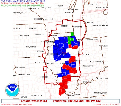
Nov 17 1346
Toledo 7-day forecast
Last Update: Nov 16, 2013 9:39 pm
This Afternoon: A chance of showers and thunderstorms, then showers and possibly a thunderstorm after 3pm. Some storms could be severe, with damaging winds. High near 67. Windy, with a south wind 26 to 30 mph, with gusts as high as 48 mph. Chance of precipitation is 80%. New rainfall amounts between a tenth and quarter of an inch, except higher amounts possible in thunderstorms.
Tonight: Showers and thunderstorms before midnight, then a slight chance of showers between midnight and 3am. Some storms could be severe, with damaging winds. Low around 43. Windy, with a west wind 21 to 28 mph, with gusts as high as 43 mph. Chance of precipitation is 90%. New rainfall amounts between a tenth and quarter of an inch, except higher amounts possible in thunderstorms.
Monday: Partly sunny, with a high near 48. Breezy, with a west wind 17 to 22 mph.
Monday Night: Partly cloudy, with a low around 30. West wind 6 to 11 mph.
Nov 17 1347
Toledo Express Airport
Nov 17, 2013 12:52 pm
Weather : Overcast and Breezy
Temperature : 66 F
Humidity : 73%
Wind Speed : S 23 mph - Gust 31 mph
Barometer : 29.55 in
Dewpoint: 57 F
Visibility : 10.00 statute miles
Toledo Executive Airport
Nov 17, 2013 12:53 pm
Weather : Mostly Cloudy and Windy
Temperature : 65 F
Humidity : 76%
Wind Speed : S 28 mph - Gust 39 mph
Barometer : 29.57 in
Dewpoint: 57 F
Visibility : 10.00 statute miles
Toledo Suburban Airport
(near Lambertville)
Nov 17, 2013 1:35 pm
Weather : Overcast
Temperature : 66 F
Humidity : 68%
Wind Speed : S 18 mph - Gust 35 mph
Barometer : 29.53 in
Dewpoint: 55 F
Visibility : 10.00 statute miles
Nov 17 - 1402
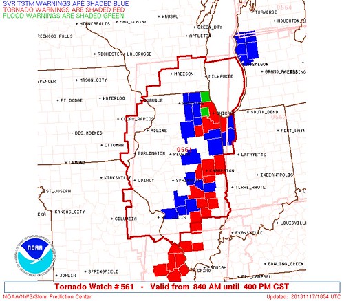
From JR's : articles
13979 words - 86396 chars
- 77 min read
created on
updated on
- #
source
- versions
- backlinks
Related articles
Nov 17, 2013 Toledo area weather notes - Mar 03, 2014
Posts related to Nov 17, 2013 severe weather - Nov 21, 2013
Toledo area weather for early December 2013 - Dec 05, 2013
Mon, Dec 9, 2013 winter storm forecast for Sat, Dec 14 - Dec 14, 2013
Winter Weather Temps for Toledo, Ohio - Feb 04, 2014
more >>