Info about the June 2012 Ohio Derecho Weather Event
(My comment in a June 2013 ToledoTalk.com thread, that discussed a severe weather threat for Ohio.)
I noticed a word in AC's above comment.
Wikipedia : Derecho
I don't think any of the government weather services have included the word "derecho" in tomorrow's forecast. Not yet, anyway.
But sorry, I just checked the media weather, concerning info about tomorrow.
http://www.weather.com/news/tornado-torcon-index
Wednesday, June 12Scattered severe thunderstorms, possibly in clusters or even a derecho (widespread damaging wind event associated with a bow echo thunderstorm pattern) in northeast IA, south WI, north half IL, north IN, south MI, OH, southwest PA, north and central WV, MD, DC, north VA.
TOR:CON - 3 north IL, south MI, north OH;
A derecho event rampaged through a portion of Ohio last summer. The worst of the system missed the Toledo area, but the storm system did a lot of damage in many areas of the state, including around Columbus.
July 2, 2012 Columbus Dispatch article titled Weather service pins storm damage on 'derecho'
Here’s a new weather word for you, one you likely will not care to hear again.Derecho. It refers to the fast-moving wind storm that ravaged Ohio on Friday evening, leaving more than 1 million without power.
The National Weather Service in Wilmington, Ohio, said the meteorological phenomenon is, thankfully, uncommon.
A derecho is defined as a long-living, widespread band of rapidly moving thunderstorms that includes wind gusts of at least 58 mph and which leaves behind at least 240 miles of wind damage.
The storm that wrecked central Ohio’s power grid began in northern Indiana on Friday afternoon and raced through the state and into West Virginia, moving at an average speed of about 75 mph over 450 miles.
The storm spewed out downbursts and microbursts, walls of wind that regularly topped 70 mph and reached hurricane-force strength of 91 mph in Fort Wayne, Ind., and 82 mph at Don Scott Field on the Northwest Side.
Wikipedia : June 2012 North American derecho
The June 2012 Mid-Atlantic and Midwest derecho was one of the most destructive and deadly fast-moving severe thunderstorm complexes in North American history.The progressive derecho tracked across a large section of the Midwestern United States and across the central Appalachians into the mid-Atlantic states on the afternoon and evening of June 29, 2012, and into the early morning of June 30, 2012.
It resulted in 22 deaths, widespread damage and millions of power outages across the entire affected region.
Images from the above Wikipedia article include an image of the SPC's convective outlook issued on June 29, 2012 for that day.


More from that Wikipedia article about Ohio's damage from that June 29, 2012 storm:
The storm was more damaging to the power grid and more severe in terms of wind gusts than Tropical Storm Ike, which hit the area [Ohio] in September 2008 with 60 mph sustained winds and 80 mph gusts after slightly re-intensifying over Indiana, making [the derecho event] both the largest power outage and the largest power outage not related to a hurricane in AEP Ohio history.Wind gusts with this derecho were closer to 85 mph, and, though of a significantly shorter duration, caused more damage to trees and power lines than Ike.
In fact, this derecho was so destructive that Accuweather compared its destruction to that of Hurricane Irene, and The Weather Channel compared it to hurricane damage in general.
Toledo Talk thread titled June 29, 2012 Weather created in the mid-afternoon that day.
Radar loop through 2:27 p.m - June 29, 2012
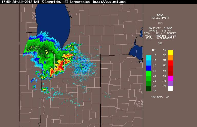
2:37 p.m. radar image - June 29, 2012
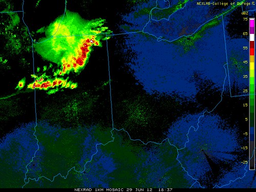
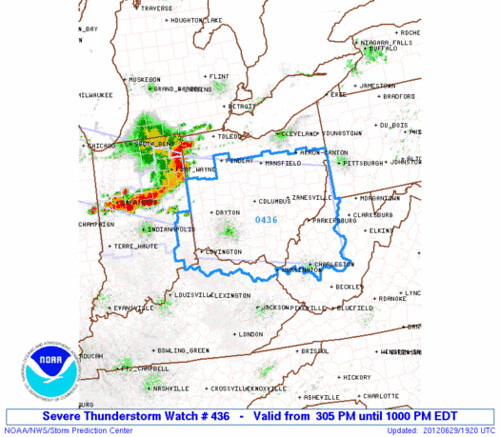
3:20 p.m. snapshot of watch box and radar - June 29, 2012 - note how the line is bowing
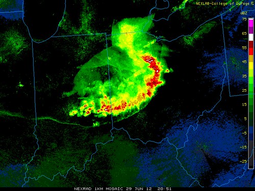
4:51 p.m. radar snapshot - June 29, 2012 - large bow-shaped line of storms - I believe the super-thin line is the outflow boundary
By JR
- 648 words
created:
- updated:
source
- versions
Related articles
Nov 17, 2013 Toledo area weather notes - Mar 03, 2014
Heavy rain and the usual street flooding - June 2008 - Nov 04, 2013
Toledo, Ohio the Venice of the Midwest - Jun 25, 2014
TT admin microblog posts - Jul 16, 2014
July 10, 2013 area storm reports - Jul 10, 2013
more >>