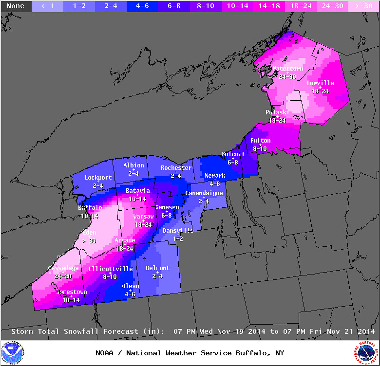
Buffalo Area Nov 2014 Lake Effect Snow Event
Nov 20, 2014 - Lake effect snow machine cranked up again south of Buffalo.
Lake Effect Snow Warning
Statement as of 3:49 AM EST on November 20, 2014
...Lake effect snow warning remains in effect until 1 am EST Friday...
- locations...Erie...Genesee...and Wyoming counties. This includes the Buffalo Metro area. Greatest accumulations expected from South Buffalo to the nearby southern and eastern suburbs extending into the southwest corner of Genesee County and the northwest corner of Wyoming counties.
- Timing...through Thursday night.
- Accumulations...3 to 6 inches through 6 am...more than 2 feet today...and 5 to 10 inches tonight.
- Winds...west 15 to 25 mph.
- Visibilities...as low as a few hundred feet at times.
- Impacts...heavy lake effect snow will result in very difficult or nearly impossible travel at times in the heaviest portion of the band. Thunder and lightning will accompany the heaviest snow. If you must travel during the lake effect snow...expect severe winter driving conditions with very low visibility and deep snow cover on roads. Some roads that have been cleared may become impassable again. Do not travel in the most heavily affected areas! Snow loads on buildings may reach critical levels and result in structural failure.
Precautionary/preparedness actions...
If you lose power and plan on running a generator...make sure that the generator is located outdoors and is properly ventilated. Space heaters should also be properly ventilated and used only if they are operating properly. Make sure snow does not block exhausts and fresh air intakes for high efficiency furnaces and water heaters.
Stay tuned to NOAA Weather Radio or your favorite source of weather information for the latest updates. Additional details can also be found at www.Weather.Gov/Buffalo.
Report snow accumulation to the National Weather Service in Buffalo by sending an email to bufstorm.Report@noaa.Gov...posting to the NWS Buffalo facebook Page...or tweet...using the hashtag bufwx
Special Statement
Statement as of 7:04 AM EST on November 20, 2014
...Lake effect snow will continue to impact the Buffalo southtowns and Lake Erie shoreline east into the higher terrain of western NY...
- at 705 am EST...National Weather Service Doppler radar indicated a lake effect snow band capable of producing snowfall rates of 3 inches per hour or more...and visibility near zero at times. This lake effect snow band was located along the Lake Erie shoreline of Chautauqua County northeast across the Boston Hills and southtowns...into much of Wyoming County.
- Some locations affected by the lake effect snow band include... Boston and West Falls... Colden...Wales...East Aurora... Concord and Bennington and Attica... Varysburg...Marilla... Warsaw...
This includes the New York thruway between exits 56 and 61.
- Lightning and a few rumbles of thunder will be possible.
Travel across the area will be extremely difficult or even impossible due to the very heavy snowfall producing near zero visibility and deep snow cover on roadways. Travel is not recommended.
If you must travel...be prepared by having an emergency kit...extra blankets and warm clothing in the event that your vehicle has mechanical problems or gets stuck. Make sure you have a fully charged cell phone.
Lat...Lon 4229 7975 4242 7946 4250 7936 4256 7916 4270 7906 4274 7892 4278 7886 4280 7886 4300 7803 4251 7817 4223 7977
Media
The snowstorm began Monday night and some areas have experienced more than five feet of snow.
On Wed, Nov 19, 2014, a story came across my Circa app that said parts of the south Buffalo area had received 72 inches of snowfall.
With another round of strong, cold winds, some areas at the eastern end of Lake Erie and Lake Ontario can expect more than two feet additional lake effect snow from Wed eve, Nov 19 to Fri eve, Nov 21.
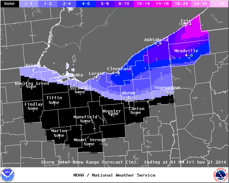
northeast ohio snowbelt forecast from Nov 20 to 1pm Nov 21.
http://www.usatoday.com/story/weather/2014/11/19/wednesday-weather/19261905/
Mesoscale Discussion

md 1928 concerning heavy snow for lee of lake erie and lake ontario
mesoscale discussion 1928
nws storm prediction center norman ok
0814 am cst thu nov 20 2014
areas affected...lee of lake erie and lake ontario
concerning...heavy snow
valid 201414z - 201845z
summary...snowfall rates /exceeding 2 inches per hour/ and the
potential for thundersnow are expected to increase by midday in lee
of lakes erie and ontario and persist through the afternoon.
discussion...trends in soundings /increasing height of the inversion
across lower mi between 00z and 12z today/ are indicative of the
cooling temperatures and height falls spreading ewd with the
approach of the upper great lakes mid-level trough. 12z sounding at
buf showed similar trends in the low-level lapse rates...and this
trend will continue as the colder air spreads ewd across the
relatively warmer lower great lakes today. forecast soundings per
12z rap/hrrr over and east of the lower great lakes confirm these
observations with an increase in buoyancy. thus...the increase in
convective depth should result in the potential for thundersnow
embedded within the ongoing bands...further enhancing the heavy
snowfall rates.
..peters.. 11/20/2014
...please see www.spc.noaa.gov for graphic product...
attn...wfo...btv...aly...bgm...buf...cle...
lat...lon 44377635 44607563 44617485 44277448 43247536 42287748
42057948 42228044 43087900 43707815 44097703 44377635
From JR's : articles
832 words - 5795 chars
- 4 min read
created on
- #
source
- versions
Related articles
Northeast ohio snowbelt lake effect snow event - november 2014 - Nov 14, 2014
Nov 17 - 19, 2014 lake effect snow event - Nov 18, 2014