You're viewing old version number 3. - Current version
Toledo Weather - Wed, May 27, 2015
Storms and/or wind gusts caused some minor damage and power outages in the Toledo area yesterday between 6:00 and 7:00 p.m.
hazardous weather outlook
national weather service cleveland oh
529 am edt wed may 27 2015
for portions of lake erie...
north central ohio...northeast ohio...northwest ohio and
northwest pennsylvania.
.day one...today and tonight
there is a slight risk of severe thunderstorms across the region
this afternoon into the evening. the main threat will be strong
damaging winds but large hail will be possible.
a weakening cold front will move into northwest ohio this
afternoon with thunderstorms developing along it. these
thunderstorms will move eastward through the evening and could
impact all of northern ohio and northwest pennsylvania.
.days two through seven...thursday through tuesday
severe thunderstorms will be possible saturday afternoon and
evening as another cold front moves across the area.
.spotter information statement...
spotter activation may be required.
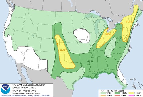
spc ac 271252
day 1 convective outlook
nws storm prediction center norman ok
0752 am cdt wed may 27 2015
valid 271300z - 281200z
...there is a slgt risk of svr tstms over parts of the oh valley...
...there is a slgt risk of svr tstms from the mid atlantic states
into new england...
...there is a slgt risk of svr tstms over the central and southern
high plains...
...there is a mrgl risk of svr tstms over parts of the central and
eastern us...
...summary...
severe storms are possible today across parts of the northern mid
atlantic coast region into northern new england...as well as parts
of the upper ohio valley and lower great lakes region...and portions
of the central high plains into the southern plains.
...ohio valley...
morning water vapor loops show a shortwave trough moving across
ia/mo. a persistent cluster of thunderstorms is associated with
this trough over southeast mo. early visible satellite imagery
shows relatively clear skies downstream of the convection...which
should allow rapid heating and destabilization. present indications
are that this cluster of storms will intensify by late morning over
southern ind/western ky and track northeastward across oh into
western pa. mlcape values over 1500 j/kg and 40-50 knots of mid
level flow support a risk of locally damaging winds and hail in
these areas.
...mid atlantic region into new england...
a band of showers currently extends from western ny southward into
wv. this weak convection is associated with a lead shortwave trough
that will move eastward into parts of the mid atlantic region and
new england later today. strong heating in this region coupled with
dewpoints in the 60s will help yield mlcape values over 1000 j/kg.
most cam solutions show scattered thunderstorm development along
this corridor by mid afternoon. low level and deep layer shear
profiles are favorable for organized/bowing storm structures capable
of locally damaging winds. any storm that can remain discrete in
this region would pose a marginal risk for a tornado as well.
...central/southern high plains...
strong heating will occur once again today over parts of eastern
co/western ky and southwest neb...southward into tx and western ok.
similar to yesterday...moderate cape values and a breakable cap will
result in isolated to scattered thunderstorms along the dryline.
the highest probability of storms appears to be from southwest neb
into northwest ok. strengthening low level winds this evening and
steep lapse rates will promote a risk of supercells capable of
hail...damaging winds...and isolated tornadoes.
..hart/gleason.. 05/27/2015
click to get wuus01 ptsdy1 product
note: the next day 1 outlook is scheduled by 1630z
fxus61 kcle 271352
afdcle
area forecast discussion
national weather service cleveland oh
952 am edt wed may 27 2015
synopsis...
a weakening cold front will cross the region late this afternoon
into the evening. high pressure will briefly be located over the
region on thursday but will move off the new england coast early
friday.
&&
near term /until 6 pm this evening/...
update...no changes for the update.
original...a weakening cold front will cross the region late this
afternoon into the evening. the area looks to be dry through the
morning but with afternoon heating and the lift near and ahead of
the front there should be some convective development. some of the
thunderstorms will have the potential to produce some stronger
wind as they cross northern ohio and nw pa. temperatures aloft may
also cool enough to allow for the development of some hail. will
mention the severe potential in the hwo.
it will be another warm day under variable amounts of cloud
cover. most locations should warm into the lower 80s.
&&
short term /6 pm this evening through saturday night/...
cold front should be east of the county warning area near or
shortly after midnight with the thunder moving eastward with it.
high pressure should then take control for about 24 hours with dry
conditions expected thursday into friday. we will have to monitor
nw ohio friday evening to see if any convection can drift into
the region ahead of the next cold front. the main push of
thunderstorms should hold off until saturday afternoon and
evening. these thunderstorms will again have a chance to become
severe.
temperatures will only cool slightly for thursday in the wake of
the weak front. most locations will be within a couple degrees of
80. cooler near the lakeshore with a lake breeze developing.
friday will see highs return to at least the middle 80s. a few
degrees cooler on saturday with more cloud cover.
&&
long term /sunday through tuesday/...
trend continues for saturdays cold front to be south of the area by
sunday. have therefore trended precip chances down...but still left
some as there are still discrepancies on how far south it gets. at
any rate it will be much cooler with high pressure building to our
north and northerly flow across our area. fair weather and high
pressure by tuesday with highs slowly trending warmer. overall
though temperatures near seasonal averages.
&&
aviation /12z wednesday through sunday/...
todays cold front that will bring showers/thunderstorms to the
terminals was located just west of chicago at 11z. expect quick
cumulus development this morning...with some mvfr ceilings at
first especially across eastern oh/nw pa. vfr by midday/early
afternoon. ssw winds will gust upwards of 30 knots today.
thunderstorms this afternoon will bring local ifr conditions and
also the potential for winds to exceed 40 knots. for
tonight...after the cold frontal passage...wind become light and
skies will at least partially clear. with lingering low level
moisture fog/br may be a possibility.
outlook...local/brief mvfr/ifr conditions saturday in shra/ts. non
vfr possible into sunday.
&&
marine...
a cold front will be crossing lake erie this evening with
potentially strong thunderstorms. southwest winds will shift to the
northwest late tonight and become light with high pressure overhead.
the high shifts east friday and southerly flow returns to the lake.
a strong cold front is expected saturday. could see a small craft
advisory for saturday into sunday.
&&
cle watches/warnings/advisories...
pa...none.
ny...none.
marine...none.
&&
$$
synopsis...mullen
near term...tk/mullen
short term...mullen
long term...oudeman
aviation...oudeman
marine...oudeman
As of 8:52 a.m. EDT on Wed, May 27, the Toledo area remains under a slight risk for severe weather yet again today.
the main threat will be strong damaging winds but large hail will be possible.
WTOL Meteorologist Ryan Wichman' tweets from this morning:
# - Pouring over data but the severe threat today looks just as high today as it did yesterday. Could be a busy PM of watches/warnings.# - Wednesday Severe Update: Timing: 3-7pm.
# - Storms Tuesday came from the south. Storms today will be coming from the west.
The NWS is looking ahead to Sat, May 30.
we will have to monitor nw ohio friday evening to see if any convection can drift into the region ahead of the next cold front.the main push of thunderstorms should hold off until saturday afternoon and evening.
these thunderstorms will again have a chance to become severe.
Some area storm reports from yesterday, May 26.
preliminary local storm report...summary
national weather service cleveland oh
1029 pm edt tue may 26 2015

..time...   ...event...      ...city location...     ...lat.lon...
..date...   ....mag....      ..county location..st.. ...source....
            ..remarks..

0537 pm     tstm wnd gst     findlay airport         41.01n 83.48w
05/26/2015  m70.00 mph       hancock            oh   asos

            kfdy asos measured a wind gust of 61kts.

0554 pm     tstm wnd gst     bowling green           41.38n 83.65w
05/26/2015  m55.00 mph       wood               oh   trained spotter

            trained spotter reported a 55 mph wind gust near bowling
            green.

0555 pm     tstm wnd dmg     1 s norwalk             41.23n 82.61w
05/26/2015                   huron              oh   trained spotter

            estimated 60 mph wind gust near norwalk. multiple 2 foot
            diameter trees down. power outage in area.

0612 pm     tstm wnd dmg     3 w gibsonburg          41.39n 83.38w
05/26/2015                   sandusky           oh   fire dept/rescue

            multiple trees down west of the town of gibsonburg on cr
            55.

0615 pm     tstm wnd dmg     helena                  41.34n 83.29w
05/26/2015                   sandusky           oh   fire dept/rescue

            overturned semi truck reported in helena.

0620 pm     tstm wnd dmg     oak harbor              41.51n 83.15w
05/26/2015                   ottawa             oh   trained spotter

            trained spotter reported several trees down in the town
            of oak harbor. the roof of an auto parts store in the
            center of town was ripped off and damaged.

0620 pm     tstm wnd dmg     5 w bucyrus             40.80n 83.07w
05/26/2015                   crawford           oh   trained spotter

            trained spotter reported a semi blown over at us 30 and
            knauss road, west of bucyrus. a barn roof was also
            damaged near this location.

0625 pm     tstm wnd dmg     4 w bucyrus             40.80n 83.05w
05/26/2015                   crawford           oh   911 call center

            reports of power poles and lines down near us 30 and cr
            22, west of bucyrus. report relayed by spotter and
            confirmed by county sheriff dispatch.

0635 pm     tstm wnd dmg     oregon                  41.67n 83.42w
05/26/2015                   lucas              oh   trained spotter

            approx. 1 square mile power outage in oregon


 <a href="/cgi-bin/junco.pl/tag/toledo">#toledo</a> <a href="/cgi-bin/junco.pl/tag/weather">#weather</a>
From JR's : articles
1623 words - 10935 chars
- 9 min read
created on
updated on
- #
source
- versions
Related articles
Severe weather threat for Sun, Nov 17, 2013 - Nov 18, 2013
Nov 17, 2013 Toledo area weather notes - Mar 03, 2014
Posts related to Nov 17, 2013 severe weather - Nov 21, 2013
Toledo area weather for early December 2013 - Dec 05, 2013
Mon, Dec 9, 2013 winter storm forecast for Sat, Dec 14 - Dec 14, 2013
more >>