Old Lucas County registered sex offenders maps mashup info
My July 2013 comment at ToledoTalk.com
"It's just data and I want more of it."
Same here. Most people will ignore the data just like the registered sex offender data, but some people may want to process the data in a different way.
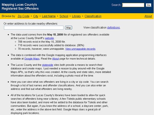
Back in 2005, the Lucas County Sheriff provided county registered sex offender data in a PDF file, which was tough to use for anything else. An XML file would have been better.
But I saved the PDF data as a text file, parsed it, and stuffed the data into a database. Since the address for each offender was included with the sheriff's data, I used a program to get the latitude and longitude coordinates for each registered sex offender, and this info was also included in the database. And then I combined my database info with Google maps to make it much easier to view the data. All legal. Others around the country had created similar maps mashups.
August 2005 thread Mapping Lucas County's registered sex offenders
You could enter an address to show the location of nearby registered sex offenders. I had programmed the addresses for all the county library locations into the database and some of the TPS elementary schools. You could filter by classification, zip code, city, and last name.
But I unplugged the app a few years later because I received multiple lawsuit threats. I used government data. Even when I explained that the person was still in the latest file produced by the sheriff, I still received the threats.
So these kinds of data mashups are sometimes best produced by a large enough media org like the Blade who can handle legal challenges.
Approx 67 percent of Lucas County's population lives in Toledo, but around 90 percent of the county's registered sex offenders lived in Toledo.
The last time that I processed the data in 2008, over 700 county offenders were in the database. The top zip codes with the most registered sex offenders were:
43604 (43)
43605 (78)
43606 (52)
43608 (61)
43609 (88)
43611 (34)
43612 (52)
43613 (42)
43615 (42)
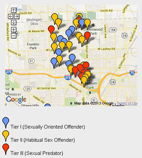
Some old screenshots from 2008:
Home Page
Offenders that lived in 43613
The Tier III (Sexual Predators) in the county
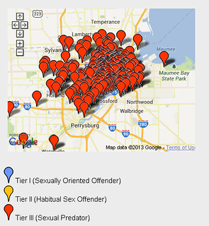
Obviously, it was possible to zoom in on the maps and click the push-pins for details.
Many websites now map or display this data, sometimes with photos, that's based upon a national registry.
- http://www.nationalpredatordatabase.com
- http://www.familywatchdog.us/search.asp
- http://www.homefacts.com/offenders.html
- http://www.drc.ohio.gov/OffenderSearch/Search.aspx
- http://www.nsopw.gov
The Toledo Blade's Data Center - "Databases, maps and helpful tools to use."
It's common for many media orgs to produce database-backed mashups of some kind, but a lot more could be done, especially locally by the orgs that have access to mountains of data. I would like to see a votes database app that shows how all current and past city council members voted on council issues.
Here's a simple example, created in 2007 that mapped city of Toledo properties that were for sale as of December 2006. The data came from a spreadsheet produced Karen Shanahan, who was a District 2 Toledo City Council candidate.
http://toledotalk.com/property
Another 2005 map mashup that I created, which mapped wifi hotspots in the Toledo area:
http://toledotalk.com/wifi
#media - #maps - #mashups - #programming - #database - #blog_jr
By JR
- 544 words
created:
- updated:
source
- versions
- backlinks
Related articles
The Guardian and Comments - April 2016 - Apr 12, 2016
Newspapers hiring programmers - Mar 20, 2014
Plain Dealer newspaper downsizes due to changes from print to digital - Oct 08, 2013
Comments about commenting systems - June 2014 - Jun 23, 2014
New media relies on new technology - Apr 27, 2014
more >>