Toledo forecasts issued on Thu, Jan 23, 2014
urgent - winter weather message
national weather service cleveland oh
319 pm est thu jan 23 2014
ohz003-006-008-017-018-027>031-036>038-047-240430-
/o.new.kcle.ws.a.0002.140125t0000z-140125t2100z/
/o.con.kcle.wc.y.0004.000000t0000z-140124t1700z/
lucas-wood-sandusky-hancock-seneca-wyandot-crawford-richland-
ashland-wayne-marion-morrow-holmes-knox-
including the cities of...toledo...bowling green...fremont...
findlay...tiffin...upper sandusky...carey...bucyrus...mansfield...
ashland...wooster...marion...mount gilead...millersburg...
mount vernon
319 pm est thu jan 23 2014
...wind chill advisory remains in effect until noon est friday...
...winter storm watch in effect from friday evening through
saturday afternoon...
a wind chill advisory remains in effect until noon friday.
- wind chill readings...10 to 24 degrees below zero.
- timing...through noon friday.
- winds...roughly 10 to 15 mph tonight increasing to 15 to 25 mph
early saturday.
- impacts...hypothermia can occur rapidly in those unprepared
for the cold. any exposed skin can experience frostbite within
a few minutes.
the national weather service in cleveland has issued a winter
storm watch...which is in effect from friday evening through
saturday afternoon.
- accumulations...accumulating snow is expected friday evening
through saturday afternoon. from 2 to 4 inches of snow is
expected west of i-71 and 3 to 5 inches east of i-71.
- timing...friday evening through saturday afternoon.
- winds...southwest winds friday night 20 to 35 mph with gusts to
over 40 mph. winds turning west saturday.
- visibilities...visibilities friday night and saturday could be
reduced to a quarter mile at times in snow and blowing snow.
- impacts...the combination of snow and blowing snow will have the
potential to significantly impact travel conditions across
northern ohio.
precautionary/preparedness actions...
a wind chill advisory is issued when the wind combines with the
temperature to make it feel like it is 10 degrees below zero or
colder for several hours or more. if you will be outdoors use
common sense and dress warmly...making sure that all exposed skin
is covered. if possible...avoid prolonged exposure to the cold to
prevent frostbite and hypothermia. stay tuned to weather radio
for further details or updates.
this winter storm watch means that accumulating snow is expected
to combine with strong winds to cause blowing and drifting...having
a significant impact to travel across the area. if you are within
the watch area...remain alert to rapidly changing weather
conditions. stay tuned to the national weather service or the
local news media for the latest updates and possible warnings.
&&
$$
hazardous weather outlook
hazardous weather outlook
national weather service cleveland oh
320 pm est thu jan 23 2014
ohz003-006-008-017-018-027>031-036>038-047-242030-
lucas-wood-sandusky-hancock-seneca-wyandot-crawford-richland-ashland-
wayne-marion-morrow-holmes-knox-
320 pm est thu jan 23 2014
...wind chill advisory in effect until noon est friday...
...winter storm watch in effect from friday evening through saturday
afternoon...
this hazardous weather outlook is for north central
ohio...northeast ohio and northwest ohio.
.day one...this afternoon and tonight.
please listen to noaa weather radio or go to weather.gov on the
internet for more information about the following hazards.
wind chill advisory.
.days two through seven...friday through wednesday.
please listen to noaa weather radio or go to weather.gov on the
internet for more information about the following hazards.
wind chill advisory.
winter storm watch.
.spotter information statement...
spotter activation is not expected at this time.
$$
page created: Jan 23, 2014 - 4:00 p.m. EST
Forecast.io
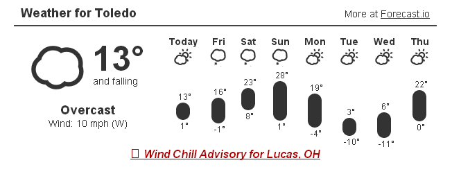
Today, Thu, Jan 23, 2014 : hi 13 lo 4
Fri : hi 16 lo 0
Sat : hi 26 lo 10
Sun : hi 20 lo 2
Mon : hi 15 lo -2
Tue : hi 3 lo -11
Wed : hi 4 lo -13
Thu : hi 14 lo -6
urgent - winter weather message
national weather service cleveland oh
321 am est thu jan 23 2014
ohz003-006-017-018-027>029-036-037-047-231630-
/o.con.kcle.wc.y.0004.000000t0000z-140123t1700z/
lucas-wood-hancock-seneca-wyandot-crawford-richland-marion-morrow-
knox-
including the cities of...toledo...bowling green...findlay...
tiffin...upper sandusky...carey...bucyrus...mansfield...marion...
mount gilead...mount vernon
321 am est thu jan 23 2014
...wind chill advisory remains in effect until noon est today...
- wind chill readings...will range from -10 to -15 degrees this
morning.
- winds...west 10 to 20 mph.
- temperatures...nearly steady between 2 and 7 above.
- impacts...exposed skin will be susceptible to frostbite.
precautionary/preparedness actions...
a wind chill advisory is issued when wind will combine with cold
temperatures to create dangerously cold conditions for exposed
skin. the wind will make it feel like it is 10 degrees below zero
or colder for a period of several hours. if you will be outdoors
use common sense and dress warmly...making sure that all exposed
skin is covered. if possible...avoid prolonged exposure to the
cold to prevent frostbite and hypothermia. stay tuned to weather
radio for further details or updates.
&&
$$
page created: Jan 23, 2014 - 6:40 a.m. EST
hazardous weather outlook
national weather service cleveland oh
401 am est thu jan 23 2014
ohz003-006-017-018-027>029-036-037-047-240915-
lucas-wood-hancock-seneca-wyandot-crawford-richland-marion-morrow-
knox-
401 am est thu jan 23 2014
...wind chill advisory in effect until noon est today...
this hazardous weather outlook is for north central ohio and
northwest ohio.
.day one...today and tonight.
please listen to noaa weather radio or go to weather.gov on the
internet for more information about the following hazards.
wind chill advisory.
a wind chill advisory will be needed again tonight and friday as
wind chill values will range from -10 to -20.
.days two through seven...friday through wednesday.
several rounds of accumulating snow will be possible through this
weekend. stay tuned to forecasts for the latest information.
.spotter information statement...
spotter activation is not expected at this time.
Toledo 7-day forecast
Last Update: Jan 23, 2014 6:15 am
Today: A chance of snow showers. Mostly cloudy, with a high near 12. Wind chill values as low as -11. West wind 11 to 15 mph. Chance of precipitation is 50%. Total daytime snow accumulation of less than a half inch possible.
Tonight: A slight chance of snow showers before 9pm. Mostly cloudy, with a low around -5. Wind chill values as low as -23. Northwest wind 9 to 14 mph becoming west after midnight. Chance of precipitation is 20%.
Friday: Areas of blowing snow after 1pm. Partly sunny, with a high near 15. Wind chill values as low as -24. Windy, with a southwest wind 15 to 20 mph increasing to 23 to 28 mph in the afternoon.
Friday Night: Areas of blowing snow and a chance of snow showers before 8pm, then snow showers likely with areas of blowing snow between 8pm and 11pm, then snow showers with areas of blowing snow after 11pm. Low around 13. Wind chill values as low as -6. Windy, with a southwest wind 22 to 28 mph. Chance of precipitation is 90%.
Saturday: Snow showers likely with areas of blowing snow before 1pm, then areas of blowing snow and a chance of snow showers after 1pm. Mostly cloudy, with a high near 22. Breezy, with a west wind 15 to 22 mph. Chance of precipitation is 60%.
Saturday Night: Mostly cloudy, with a low around 3.
Sunday: Snow showers likely. Cloudy, with a high near 19. Chance of precipitation is 70%.
Sunday Night: A chance of snow showers. Cloudy, with a low around 2. Chance of precipitation is 50%.
Monday: Partly sunny and cold, with a high near 8.
Monday Night: Mostly cloudy, with a low around -8.
Tuesday: Cloudy and cold, with a high near 4.
Tuesday Night: Cloudy, with a low around -3.
Wednesday: Mostly cloudy, with a high near 14.
fxus61 kcle 231116
afdcle
area forecast discussion
national weather service cleveland oh
616 am est thu jan 23 2014
synopsis...
a series of clipper lows will move southeast through the region into
early next week then high pressure will try and build over the ohio
valley for the middle of next week.
&&
near term /until 6 pm this evening/...
the current clipper affecting the area will continue to weaken and
shift off to the east today. wrap moisture and upper level low
pressure will combine to keep a good threat for nuisance snow going
but the threat should start to shift more toward just the snowbelt
as evening begins. accumulation today should less than an inch
although some areas in the snowbelt could see local amounts of
another inch or so.
will let the current wind chill advisory in the west serve as the
headline du jour for now.
&&
short term /6 pm this evening through sunday night/...
high pressure ridging into the area...the upper level trough
shifting east and drier air spreading in from the west should work
to continue ending the snow from west to east tonight. some flurries
or a few light snow showers may hang on over the east part of the
snowbelt going into fri morning but should end by noon.
another wind chill advisory will again be needed for tonight and a
good part of fri as winds increase.
the next clipper will affect the area fri night thru sat. current
forecast has handle on situation so little changes to be made other
than to increase accumulation more...to maybe 2 to 4 inches. the
usual shift to mainly lake effect looks on track for later sat into
sat night. think precip from the next clipper will stay west of the
area thru daybreak sun.
yet more wind chill headlines look likely for sat night.
another clipper expected to move across the area sun into sun night
with more widespread light snow...again followed by reinforcing
arctic air.
&&
long term /monday through wednesday/...
another reinforcing upper level trough will dig south across the
eastern united states for early and mid week for next week. this
upper level trough will have a resultant surface low pressure system
that will track east toward the lower great lakes on sunday and then
across the forecast area on monday. once the low moves northeast of
the region...an arctic cold front will slide south across the area.
this will allow another shot of arctic air to move into the region
for the early part of next week. this air mass will be colder than
what we have seen in recent days.
snow associated with the low pressure system will begin to move east
and out of the area on monday afternoon and evening as drier air
moves into the area. a lingering trough of low pressure will sweep
through the region on tuesday and only residual lake effect moisture
will remain present tuesday. high pressure will build northeast into
the forecast area on wednesday and then to the east coast wednesday
night. so...fair weather should return at least for wednesday. we
should begin to see some warm air advection taking place by
wednesday evening on the back side of the high pressure center. this
will result in some warming by wednesday after some pretty cold
temperatures to start the work week.
&&
aviation /12z thursday through monday/...
low pressure will move east across the southern great lakes this
morning and continue some light snow across the area. there will
be brief pockets of visibilities reduced to 1 mile at cle and eri
with the snow but i think these will be short lived enough to
leave out of the tafs. otherwise...should see visibilities between
3 to 5 miles with light snow and ceilings around 1500 feet through
the morning. snow should end by early afternoon as low pulls out
to the east and ceilings will improve overnight. winds will shift
to a northwesterly direction and then swing around to a southwest
direction tonight.
outlook...non vfr saturday through monday.
&&
marine...
gale watch will remain in effect. although...confidence is starting
to dwindle as with each successive model run...the winds are backing
off little by little. there is still the chance we could see gales
friday afternoon into saturday so will keep the watch going.
in the mean time...winds will be relatively light on the lake
through friday morning and then gradually increase during the day
friday. a cold front will sweep east across the lake and cause winds
to diminish slightly along the front and then pick up again to gale
force on saturday after the front. winds diminish fairly quickly
saturday night into sunday morning and become southerly by
afternoon. another cold front moves through sunday night and this
will cause winds to become westerly but should remain below gale
force on monday.
&&
cle watches/warnings/advisories...
oh...wind chill advisory until noon est today for ohz003-006-017-
018-027>029-036-037-047.
pa...none.
marine...gale watch from friday afternoon through saturday evening for
lez061-142>149-162>169.
&&
$$
synopsis...adams
near term...adams
short term...adams
long term...lombardy
aviation...lombardy
marine...lombardy
My Thu afternoon, Jan 23, 2014 TT comment:
From the above Winter Storm Watch forecast conditions for tomorrow night and Saturday:
- accumulations...accumulating snow is expected friday evening through saturday afternoon. from 2 to 4 inches of snow is expected west of i-71 and 3 to 5 inches east of i-71.
- winds...southwest winds friday night 20 to 35 mph with gusts to over 40 mph. winds turning west saturday.
- visibilities...visibilities friday night and saturday could be reduced to a quarter mile at times in snow and blowing snow.
The snowfall amount matters less, but those forecast winds and reduced visibilities are close to meeting the criteria for a blizzard.
A blizzard means that the following conditions are expected to prevail for a period of 3 hours or longer:
- Sustained wind or frequent gusts to 35 miles an hour or greater; and
- Considerable falling and/or blowing snow (i.e., reducing visibility frequently to less than 1/4 mile)
Anyway, this good old fashioned winter weather will continue for at least the next seven days. A couple inches of snow on Saturday and maybe a couple more on Sunday.
should get a break saturday night and then the next clipper will move through and likely drop a good 1-3 or 2-4 inch amount sunday
And then the temps cool off again early next week.
From JR's : articles
2244 words - 14429 chars
- 12 min read
created on
updated on
- #
source
- versions
Related articles
Severe weather threat for Sun, Nov 17, 2013 - Nov 18, 2013
Nov 17, 2013 Toledo area weather notes - Mar 03, 2014
Posts related to Nov 17, 2013 severe weather - Nov 21, 2013
Toledo area weather for early December 2013 - Dec 05, 2013
Mon, Dec 9, 2013 winter storm forecast for Sat, Dec 14 - Dec 14, 2013
more >>