Toledo weather - Sun, Jan 26, 2014
Toledo 7-day forecast
Last Update: Jan 26, 2014 9:18 am
Today: Snow showers with areas of blowing snow before 3pm, then snow showers likely after 3pm. High near 29. Breezy, with a south wind 15 to 20 mph. Chance of precipitation is 100%. Total daytime snow accumulation of 1 to 2 inches possible.
Tonight: Snow showers likely, mainly before 8pm. Cloudy, with a low around 8. Wind chill values as low as -9. Breezy, with a west wind 21 to 23 mph. Chance of precipitation is 60%. New snow accumulation of less than one inch possible.
Monday: A chance of snow showers, mainly before 11am. Partly sunny and cold, with a temperature falling to around 2 by 5pm. Wind chill values as low as -17. Breezy, with a west wind 16 to 22 mph. Chance of precipitation is 40%. New snow accumulation of less than a half inch possible.
Monday Night: Mostly cloudy, with a low around -13. Wind chill values as low as -33. West wind 13 to 16 mph.
Tuesday: Mostly sunny and cold, with a high near -1. Southwest wind 14 to 16 mph.
Tuesday Night: Partly cloudy, with a low around -10.
Wednesday: Mostly sunny and cold, with a high near 10.
Wednesday Night: Partly cloudy, with a low around 5. Breezy.
Thursday: A chance of snow. Mostly cloudy, with a high near 23. Breezy. Chance of precipitation is 40%.
Thursday Night: Mostly cloudy, with a low around 10.
Friday: Partly sunny, with a high near 20.
Friday Night: A chance of snow. Mostly cloudy, with a low around 13. Chance of precipitation is 30%.
Saturday: A chance of snow. Cloudy, with a high near 27. Chance of precipitation is 40%.
hazardous weather outlook
national weather service cleveland oh
400 am est sun jan 26 2014
ohz003-006>014-017>023-027>033-036>038-047-089-paz001>003-270900-
lucas-wood-ottawa-sandusky-erie oh-lorain-cuyahoga-lake-geauga-
ashtabula inland-hancock-seneca-huron-medina-summit-portage-trumbull-
wyandot-crawford-richland-ashland-wayne-stark-mahoning-marion-morrow-
holmes-knox-ashtabula lakeshore-northern erie-southern erie-
crawford pa-
400 am est sun jan 26 2014
...wind chill advisory in effect until 10 am est this morning...
this hazardous weather outlook is for north central
ohio...northeast ohio...northwest ohio and northwest pennsylvania.
.day one...today and tonight.
please listen to noaa weather radio or go to weather.gov on the
internet for more information about the following hazards.
wind chill advisory.
a storm system will bring another 1 to 3 inches of snow to most of
the area today and tonight.
.days two through seven...monday through saturday.
another arctic outbreak will invade the area early next week.
overnight lows monday night and tuesday night will be in the minus
10 to minus 15 degree range...with wind chills around minus 30.
these will be the coldest temperatures since 1994.
.spotter information statement...
spotter activation is not expected at this time.
$$
fxus61 kcle 261134
afdcle
area forecast discussion
national weather service cleveland oh
634 am est sun jan 26 2014
synopsis...
high pressure centered along the ohio river will move off to the
east this morning. this will allow low pressure over the northern
plains to move east over the central great lakes later today. a
cold front from this low will move across the local area tonight.
very strong arctic high pressure will then build over the region
from the west through mid-week.
&&
near term /until 6 pm this evening/...
the snow is approaching fast and should arrive this morning on
schedule. no real changes to the forecast. quite a few spots now
hitting wind chill advisory criteria.
original...some lingering light snow showers continue to the east and south
of kcle this morning. most of this activity should go away by
daybreak. some clearing has occurred over portions of the area
which has allowed temps to dip into the lower single digits. just
now starting to see some locations hit wind chill advisory criteria
and will leave the headline go as is. new guidance similar with the
next wave of precip today. expect snow to move into the i-75
corridor after 12z. the precip shield should make it over the west
1/2 to 2/3 of the area by midday. qpf amounts from the models are
nearly identical and should see a general 2 inch snowfall today.
there should be a pretty good warm up today with highs similar to
yesterday.
&&
short term /6 pm this evening through tuesday night/...
the big story today will be the bitter cold during the period.
will let the day crew deal with additional headlines. expect that
another wind chill advisory will be needed for tonight with
possible warnings monday into tuesday. given forecast lows in the
neg teens the cold wind chills shouldn't come as a surprise and
will hit the hwo hard today.
another piece of energy will move through tonight and expect
another period of light snow to develop. much of the evening
should be dry...especially in the west but another inch or so is
possible after midnight. amounts may be a tad higher in the se.
after that strong cold air advection will get going. will need
chances for lake effect into tuesday. the airmass will be very dry
so do not expect to need any headlines. clearing should occur on
monday in the west and all areas on tuesday. could see wind chills
colder than neg 25 on tuesday morning. this will be just a tad
warmer than the event a couple weeks ago but will be longer in
duration with two nights of frigid weather. have used a blend of
guidance during the period. much of the area will see high temps
on tue day below zero. the last time that occurred was 1994.
&&
long term /wednesday through saturday/...
some concern that a little lingering lake effect could be affecting
erie co pa on wed but for continuity will stay with a dry forecast.
a sw return flow will allow temps to shoot up to around 10 deg. a
weak cold front is expected to move across the area around thu night
then stall just se of the area fri until a wave develops and rides
along the front up the oh river valley sat. ongoing forecast seems
in line with chance pops thu into thu night. will increase pops fri
into fri night for threat of overrunning snow developing. temps
aloft and thicknesses indicate a question of precip type for sat but
based on guidance surface temps will stay with just mention of snow.
&&
aviation /12z sunday through thursday/...
a large band of snow will move east across the area today. the snow
should last about 4 or 5 hours on average and expect vsbys to drop
into a 1/2sm to 1 1/2sm range. some nuisance flurries or light snow
showers may linger over the ne half of the area behind the main band
of snow later today. areas of light snow are expected tonight so
will hang on to mvfr conditions.
winds gusting to 25 to 30 knots today and tonight will produce
blowing causing locally reduced visibilities.
outlook...non vfr monday. non vfr mainly in the snow belt monday
night into tuesday.
&&
marine...
winds behind another clipper moving thru late today and early
tonight should veer to west and increase to 30 knots with some
chance that marginal gales could briefly occur. winds should settle
into mainly a 15 to 25 knot range from midday mon thru wed and back
to sw by late wed. winds should increase to 20 to 30 knots for thu.
&&
cle watches/warnings/advisories...
oh...wind chill advisory until 10 am est this morning for ohz003-
006>014-017>023-027>033-036>038-047-089.
pa...wind chill advisory until 10 am est this morning for
paz001>003.
marine...none.
&&
$$
synopsis...kubina
near term...kubina
short term...kubina
long term...adams
aviation...adams
marine...adams
urgent - winter weather message
national weather service cleveland oh
256 pm est sun jan 26 2014
...an arctic cold front will move across the area overnight
ushering in some of the coldest temperatures of the season. the
frigid conditions will last through mid week.
ohz003-006>014-017>023-027>033-036>038-047-089-paz001>003-270400-
/o.new.kcle.wc.y.0007.140126t2000z-140127t2000z/
lucas-wood-ottawa-sandusky-erie oh-lorain-cuyahoga-lake-geauga-
ashtabula inland-hancock-seneca-huron-medina-summit-portage-
trumbull-wyandot-crawford-richland-ashland-wayne-stark-mahoning-
marion-morrow-holmes-knox-ashtabula lakeshore-northern erie-
southern erie-crawford pa-
including the cities of...toledo...bowling green...port clinton...
fremont...sandusky...lorain...cleveland...mentor...chardon...
jefferson...findlay...tiffin...norwalk...medina...akron...
ravenna...warren...upper sandusky...carey...bucyrus...mansfield...
ashland...wooster...canton...youngstown...marion...mount gilead...
millersburg...mount vernon...ashtabula...erie...edinboro...
meadville
256 pm est sun jan 26 2014
...wind chill advisory in effect until 3 pm est monday...
the national weather service in cleveland has issued a wind chill
advisory...which is in effect until 3 pm est monday.
- wind chill readings...wind chills will dip to 10 to 15 below
zero overnight...and will remain well below zero on monday. in
addition...another arctic blast will plunge wind chills on
monday night and tuesday night to around 30 degrees below zero.
- winds...west to northwest winds will increase to 15 to 25 mph
with gusts to 35 mph. winds will be stronger near the
lakeshore.
- temperatures...in the single digits tonight with temperatures of
10 to 15 degrees below zero monday night and tuesday night.
- impacts...exposed skin will be susceptible to frostbite.
precautionary/preparedness actions...
if you will be outdoors use common sense and dress warmly...in
layers...making sure that all exposed skin is covered. avoid
prolonged exposure to the cold...if possible to prevent frostbite
and hypothermia. stay tuned to weather radio for further details or
updates.
urgent - winter weather message
national weather service cleveland oh
625 pm est sun jan 26 2014
...more arctic air will be overspreading the region during the
next few days...
.an arctic cold front will move across the area overnight ushering
in some of the coldest temperatures of season. the frigid
conditions will last through mid week. some blowing and drifting
snow will occur especially tonight into monday night. motorists
will have to use caution.
ohz003-006>009-017>019-027>030-036-037-047-270730-
/o.can.kcle.wc.y.0007.000000t0000z-140127t2000z/
/o.new.kcle.wc.w.0002.140127t2300z-140128t1700z/
/o.new.kcle.wc.y.0008.140127t0500z-140127t2300z/
/o.new.kcle.wc.a.0002.140128t1700z-140129t1700z/
lucas-wood-ottawa-sandusky-erie oh-hancock-seneca-huron-wyandot-
crawford-richland-ashland-marion-morrow-knox-
including the cities of...toledo...bowling green...port clinton...
fremont...sandusky...findlay...tiffin...norwalk...
upper sandusky...carey...bucyrus...mansfield...ashland...marion...
mount gilead...mount vernon
625 pm est sun jan 26 2014
...wind chill advisory in effect from midnight tonight to 6 pm
est monday...
...wind chill warning in effect from 6 pm monday to noon est
tuesday...
...wind chill watch in effect from tuesday afternoon through
wednesday morning...
the national weather service in cleveland has issued a wind chill
warning...which is in effect from 6 pm monday to noon est
tuesday. a wind chill advisory has also been issued. this wind
chill advisory is in effect from midnight tonight to 6 pm est
monday. in addition...a wind chill watch has been issued. this
wind chill watch is in effect from tuesday afternoon through
wednesday morning.
- wind chill readings...wind chills will dip to 10 to 15 below
zero overnight...and will remain well below zero on monday. in
addition...another arctic blast will plunge wind chills monday
night through wednesday morning to around 30 degrees below zero
at times.
- winds...west to northwest winds will increase to 15 to 25 mph
with gusts to 35 mph tonight and continue into monday night and
then decrease some for tuesday and tuesday night. winds will be
stronger near the lakeshore.
- temperatures...will be around freezing this evening and then
drop after the front moves through. by daybreak monday readings
will be in the single digits with temperatures of 10 below to 15
below zero monday night and tuesday night.
- impacts...exposed skin will be susceptible to frostbite. the
winds will cause some blowing and drifting snow. motorists will
have to use caution.
precautionary/preparedness actions...
if you will be outdoors use common sense and dress warmly...in
layers...making sure that all exposed skin is covered. avoid
prolonged exposure to the cold...if possible to prevent frostbite
and hypothermia. stay tuned to weather radio for further details
or updates.
a wind chill warning is issued when a strong wind will combine
with cold temperatures to create dangerously cold conditions for
exposed skin. the wind will make it feel like it is 25 degrees
below zero or colder for several hours. those planning to venture
outdoors should use common sense and dress warmly.
a wind chill advisory is issued when strong wind will combine
with cold temperatures to create dangerously cold conditions for
exposed skin. the wind will make it feel like it is 10 degrees
below zero or colder for a period of several hours. if you will
be outdoors use common sense and dress warmly...making sure that
all exposed skin is covered. if possible...avoid prolonged
exposure to the cold to prevent frostbite and hypothermia. stay
tuned to weather radio for further details or updates.
a wind chill watch is issued when strong winds will combine with
cold temperatures to create dangerously cold conditions for
exposed skin. the wind will make it feel like it is 15 degrees
below zero or colder for a period of several hours. if you will
be outdoors use common sense and dress warmly...making sure that
all exposed skin is covered. if possible...avoid prolonged
exposure to the cold to prevent frostbite and hypothermia. stay
tuned to weather radio for further details or updates.
&&
$$
hazardous weather outlook
hazardous weather outlook
national weather service cleveland oh
709 pm est sun jan 26 2014
ohz003-006>009-017>019-027>030-036-037-047-280015-
lucas-wood-ottawa-sandusky-erie oh-hancock-seneca-huron-wyandot-
crawford-richland-ashland-marion-morrow-knox-
709 pm est sun jan 26 2014
...wind chill advisory in effect from midnight tonight to 6 pm est
monday...
...wind chill warning in effect from 6 pm monday to noon est
tuesday...
...wind chill watch in effect from tuesday afternoon through
wednesday morning...
this hazardous weather outlook is for north central ohio and
northwest ohio.
.day one...tonight.
please listen to noaa weather radio or go to weather.gov on the
internet for more information about the following hazards.
wind chill advisory.
some blowing and drifting snow will occur...motorists will have to
use caution.
.days two through seven...monday through saturday.
please listen to noaa weather radio or go to weather.gov on the
internet for more information about the following hazards.
wind chill advisory.
wind chill warning.
wind chill watch.
some blowing and drifting snow will occur through at least monday
evening.
.spotter information statement...
spotter activation is not expected at this time.
$$
wind chill watch
urgent - winter weather message
national weather service cleveland oh
625 pm est sun jan 26 2014
...more arctic air will be overspreading the region during the
next few days...
.an arctic cold front will move across the area overnight ushering
in some of the coldest temperatures of season. the frigid
conditions will last through mid week. some blowing and drifting
snow will occur especially tonight into monday night. motorists
will have to use caution.
ohz003-006>009-017>019-027>030-036-037-047-270730-
/o.can.kcle.wc.y.0007.000000t0000z-140127t2000z/
/o.new.kcle.wc.w.0002.140127t2300z-140128t1700z/
/o.new.kcle.wc.y.0008.140127t0500z-140127t2300z/
/o.new.kcle.wc.a.0002.140128t1700z-140129t1700z/
lucas-wood-ottawa-sandusky-erie oh-hancock-seneca-huron-wyandot-
crawford-richland-ashland-marion-morrow-knox-
including the cities of...toledo...bowling green...port clinton...
fremont...sandusky...findlay...tiffin...norwalk...
upper sandusky...carey...bucyrus...mansfield...ashland...marion...
mount gilead...mount vernon
625 pm est sun jan 26 2014
...wind chill advisory in effect from midnight tonight to 6 pm
est monday...
...wind chill warning in effect from 6 pm monday to noon est
tuesday...
...wind chill watch in effect from tuesday afternoon through
wednesday morning...
the national weather service in cleveland has issued a wind chill
warning...which is in effect from 6 pm monday to noon est
tuesday. a wind chill advisory has also been issued. this wind
chill advisory is in effect from midnight tonight to 6 pm est
monday. in addition...a wind chill watch has been issued. this
wind chill watch is in effect from tuesday afternoon through
wednesday morning.
- wind chill readings...wind chills will dip to 10 to 15 below
zero overnight...and will remain well below zero on monday. in
addition...another arctic blast will plunge wind chills monday
night through wednesday morning to around 30 degrees below zero
at times.
- winds...west to northwest winds will increase to 15 to 25 mph
with gusts to 35 mph tonight and continue into monday night and
then decrease some for tuesday and tuesday night. winds will be
stronger near the lakeshore.
- temperatures...will be around freezing this evening and then
drop after the front moves through. by daybreak monday readings
will be in the single digits with temperatures of 10 below to 15
below zero monday night and tuesday night.
- impacts...exposed skin will be susceptible to frostbite. the
winds will cause some blowing and drifting snow. motorists will
have to use caution.
precautionary/preparedness actions...
if you will be outdoors use common sense and dress warmly...in
layers...making sure that all exposed skin is covered. avoid
prolonged exposure to the cold...if possible to prevent frostbite
and hypothermia. stay tuned to weather radio for further details
or updates.
a wind chill warning is issued when a strong wind will combine
with cold temperatures to create dangerously cold conditions for
exposed skin. the wind will make it feel like it is 25 degrees
below zero or colder for several hours. those planning to venture
outdoors should use common sense and dress warmly.
a wind chill advisory is issued when strong wind will combine
with cold temperatures to create dangerously cold conditions for
exposed skin. the wind will make it feel like it is 10 degrees
below zero or colder for a period of several hours. if you will
be outdoors use common sense and dress warmly...making sure that
all exposed skin is covered. if possible...avoid prolonged
exposure to the cold to prevent frostbite and hypothermia. stay
tuned to weather radio for further details or updates.
a wind chill watch is issued when strong winds will combine with
cold temperatures to create dangerously cold conditions for
exposed skin. the wind will make it feel like it is 15 degrees
below zero or colder for a period of several hours. if you will
be outdoors use common sense and dress warmly...making sure that
all exposed skin is covered. if possible...avoid prolonged
exposure to the cold to prevent frostbite and hypothermia. stay
tuned to weather radio for further details or updates.
&&
$$
page created: Jan 26, 2014 - 7:30 p.m. EST
Toledo 7-day forecast
Last Update: Jan 26, 2014 6:46 pm
Tonight: Snow with areas of blowing snow before 2am, then areas of blowing snow and a chance of snow after 2am. Low around 4. Wind chill values as low as -13. Breezy, with a west wind 15 to 24 mph, with gusts as high as 34 mph. Chance of precipitation is 90%. Total nighttime snow accumulation of around an inch possible.
Monday: Areas of blowing snow and a chance of snow before 9am, then areas of blowing snow and a slight chance of snow between 9am and 1pm, then areas of blowing snow after 1pm. Mostly cloudy and cold, with a high near 9. Wind chill values as low as -18. Breezy, with a west wind 18 to 23 mph, with gusts as high as 33 mph. Chance of precipitation is 30%. New snow accumulation of less than a half inch possible.
Monday Night: Areas of blowing snow. Mostly cloudy, with a low around -12. Wind chill values as low as -34. West wind around 16 mph.
Tuesday: Sunny and cold, with a high near -1. Wind chill values as low as -34. West wind 15 to 17 mph.
Tuesday Night: Mostly clear, with a low around -9. Southwest wind around 16 mph.
Wednesday: Sunny and cold, with a high near 9.
Wednesday Night: Partly cloudy, with a low around 5. Breezy.
Thursday: A chance of snow. Mostly cloudy, with a high near 24. Breezy. Chance of precipitation is 40%.
Thursday Night: Mostly cloudy, with a low around 9.
Friday: Partly sunny, with a high near 21.
Friday Night: A chance of snow. Mostly cloudy, with a low around 11. Chance of precipitation is 30%.
Saturday: A chance of snow. Cloudy, with a high near 27. Chance of precipitation is 40%.
Saturday Night: A chance of snow. Mostly cloudy, with a low around 16. Chance of precipitation is 30%.
Sunday: Mostly cloudy, with a high near 27.
special weather statement
national weather service cleveland oh
1056 pm est sun jan 26 2014
ohz003-006>009-017>019-027>030-036-037-047-270530-
lucas-wood-ottawa-sandusky-erie oh-hancock-seneca-huron-wyandot-
crawford-richland-ashland-marion-morrow-knox-
including the cities of...toledo...bowling green...port clinton...
fremont...sandusky...findlay...tiffin...norwalk...
upper sandusky...carey...bucyrus...mansfield...ashland...marion...
mount gilead...mount vernon
1056 pm est sun jan 26 2014
a strong arctic front will sweep across the region late tonight. a
winter weather advisory is in effect for snow and blowing snow.
winds could gust up to 45 mph after the frontal passage and
combined with some snow that will cause plenty of blowing and
drifting snow and whiteout conditions at times. travel could be
very dangerous if not impossible. new snow should only be around an inch.
during the day monday winds will be a little gusty and cause some
blowing and drifting snow.
before the frontal passage temperatures will be around 30 and then
drop into single digits by daybreak and then continue to drop.
wind chill advisory criteria will be met later on monday.
urgent - winter weather message
national weather service cleveland oh
1013 pm est sun jan 26 2014
...more arctic air will be overspreading the region during the
next few days...
.an arctic cold front will move across the area overnight
ushering in some of the coldest temperatures of season. the
frigid conditions will last through mid week.
after the front moves through the winds will gust between 35 and
45 mph for several hours overnight and early monday morning.
plenty of blowing and drifting snow will occur as the winds gusts
and whiteout conditions are likely. the winds will decrease
several hours after the front moves through but will still be
gusty and cause blowing and drifting snow. wind chill advisory
conditions will then develop. the winter weather advisory for
blowing and drifting snow may have to be expanded into northeast
ohio and northwest pennsylvania.
Images
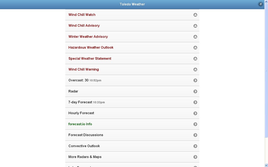
Sunday evening, January 26, 2014 - my ToledoWX web app home page
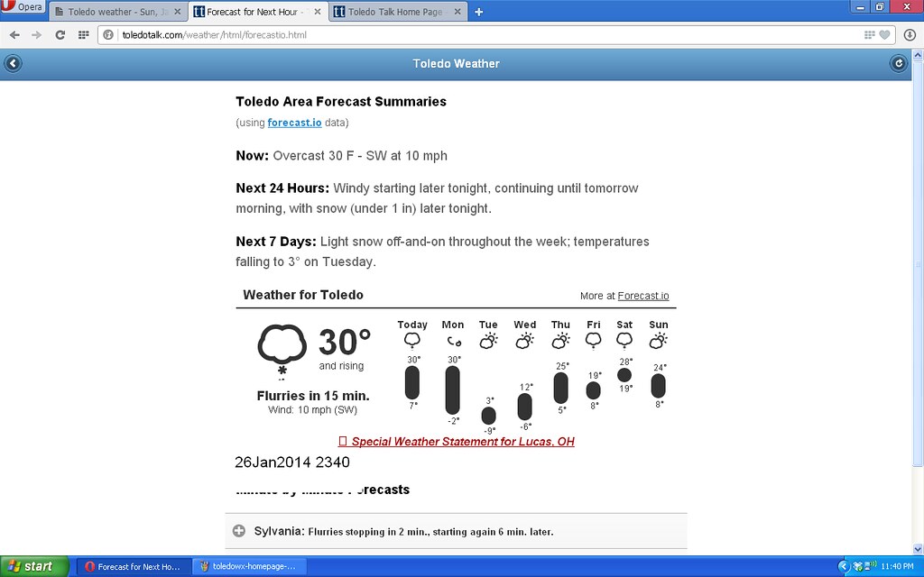
Late Sunday night, Forecast.io info:
From JR's : articles
3557 words - 23368 chars
- 19 min read
created on
updated on
- #
source
- versions
Related articles
Severe weather threat for Sun, Nov 17, 2013 - Nov 18, 2013
Nov 17, 2013 Toledo area weather notes - Mar 03, 2014
Posts related to Nov 17, 2013 severe weather - Nov 21, 2013
Toledo area weather for early December 2013 - Dec 05, 2013
Mon, Dec 9, 2013 winter storm forecast for Sat, Dec 14 - Dec 14, 2013
more >>