Toledo weather - Tue, Jan 28, 2014
Toledo Express Airport:
Jan 28, 2014 6:52 am.
Weather : Fair.
Temperature : -10 F.
Humidity : 74%.
Wind Speed : SW 9 mph.
Barometer : 30.38 in.
Dewpoint: -16 F.
Visibility : 10.00 statute miles.
Wind Chill : -27 F.
Toledo Executive Airport formerly Metcalf Airport):
Jan 28, 2014 6:53 am.
Weather : Fair.
Temperature : -9 F.
Humidity : 71%.
Wind Speed : SW 13 mph.
Barometer : 30.40 in.
Dewpoint: -16 F.
Visibility : 10.00 statute miles.
Wind Chill : -30 F.
Toledo Suburban Airport (near Lambertville):
Jan 28, 2014 6:55 am.
Weather : Fair.
Temperature : -6 F.
Humidity : 64%.
Wind Speed : SW 9 mph.
Barometer : 30.38 in.
Dewpoint: -15 F.
Visibility : 10.00 statute miles.
Wind Chill : -22 F.
hazardous weather outlook
national weather service cleveland oh
357 am est tue jan 28 2014
ohz003-006>014-017>023-027>033-036>038-047-089-paz001>003-291100-
lucas-wood-ottawa-sandusky-erie oh-lorain-cuyahoga-lake-geauga-
ashtabula inland-hancock-seneca-huron-medina-summit-portage-trumbull-
wyandot-crawford-richland-ashland-wayne-stark-mahoning-marion-morrow-
holmes-knox-ashtabula lakeshore-northern erie-southern erie-
crawford pa-
357 am est tue jan 28 2014
...wind chill warning in effect until noon est wednesday...
this hazardous weather outlook is for north central
ohio...northeast ohio...northwest ohio and northwest pennsylvania.
.day one...today and tonight.
please listen to noaa weather radio or go to weather.gov on the
internet for more information about the following hazards.
wind chill warning.
.days two through seven...wednesday through monday.
please listen to noaa weather radio or go to weather.gov on the
internet for more information about the following hazards.
wind chill warning.
.spotter information statement...
spotter activation is not expected at this time.
urgent - winter weather message
national weather service cleveland oh
327 am est tue jan 28 2014
ohz003-006>013-017>023-027>033-036>038-047-paz003-281700-
/o.con.kcle.wc.w.0002.000000t0000z-140129t1700z/
lucas-wood-ottawa-sandusky-erie oh-lorain-cuyahoga-lake-geauga-
hancock-seneca-huron-medina-summit-portage-trumbull-wyandot-
crawford-richland-ashland-wayne-stark-mahoning-marion-morrow-
holmes-knox-crawford pa-
including the cities of...toledo...bowling green...port clinton...
fremont...sandusky...lorain...cleveland...mentor...chardon...
findlay...tiffin...norwalk...medina...akron...ravenna...warren...
upper sandusky...carey...bucyrus...mansfield...ashland...
wooster...canton...youngstown...marion...mount gilead...
millersburg...mount vernon...meadville
327 am est tue jan 28 2014
...wind chill warning remains in effect until noon est
wednesday...
- winds...west to southwest winds of 10 to 15 mph. isolated gusts
around 25 mph.
- temperatures...only zero to 5 above today and 8 to 12 degrees
below zero tonight.
- wind chill readings...15 to 30 below zero will be common much of
time.
- timing...through wednesday morning.
- impacts...hypothermia and frostbite.
precautionary/preparedness actions...
if you will be outdoors use common sense and dress warmly...in
layers...making sure that all exposed skin is covered. avoid
prolonged exposure to the cold...if possible to prevent frostbite
and hypothermia.
a wind chill warning is issued when a strong wind will combine
with cold temperatures to create dangerously cold conditions for
exposed skin. the wind will make it feel like it is 25 degrees
below zero or colder for several hours.
stay tuned to noaa weather radio for further details or updates.
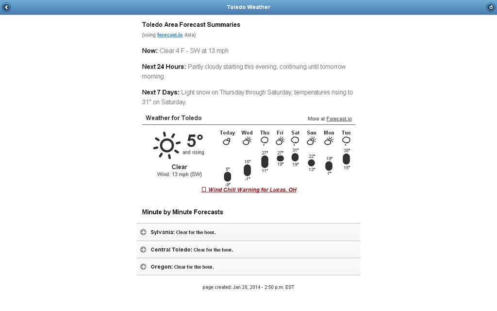
Toledo 7-day forecast
Last Update: Jan 28, 2014 6:26 am
Today: Sunny and cold, with a high near 3. Wind chill values as low as -30. Southwest wind 11 to 15 mph.
Tonight: Mostly clear, with a low around -8. Wind chill values as low as -27. Southwest wind 13 to 15 mph.
Wednesday: Mostly sunny, with a high near 13. Wind chill values as low as -28. Southwest wind 14 to 16 mph.
Wednesday Night: Mostly clear, with a low around 9. Wind chill values as low as -8. Southwest wind around 14 mph.
Thursday: A slight chance of snow after 2pm. Partly sunny, with a high near 27. Breezy, with a south wind 15 to 20 mph. Chance of precipitation is 20%.
Thursday Night: A chance of snow, mainly after 8pm. Mostly cloudy, with a low around 17. Chance of precipitation is 50%.
Friday: A chance of snow. Mostly cloudy, with a high near 25. Chance of precipitation is 50%.
Friday Night: A chance of snow. Mostly cloudy, with a low around 17. Chance of precipitation is 40%.
Saturday: A chance of snow. Cloudy, with a high near 29. Chance of precipitation is 50%.
Saturday Night: A chance of snow. Mostly cloudy, with a low around 15. Chance of precipitation is 50%.
Sunday: Partly sunny, with a high near 25.
Sunday Night: Mostly cloudy, with a low around 11.
Monday: Mostly cloudy, with a high near 26.
Toledo Hourly Forecast
8:00 am - Jan 28, 2014
temp: -10 F
wind: WSW 11 mph
wind chill: -30 F
precip chance 4 cloud cover amount 13
9:00 am - Jan 28, 2014
temp: -8 F
wind: WSW 13 mph
wind chill: -28 F
precip chance 5 cloud cover amount 14
10:00 am - Jan 28, 2014
temp: -5 F
wind: SW 14 mph
wind chill: -25 F
precip chance 4 cloud cover amount 16
11:00 am - Jan 28, 2014
temp: -4 F
wind: SW 15 mph
wind chill: -24 F
precip chance 5 cloud cover amount 18
12:00 pm - Jan 28, 2014
temp: -2 F
wind: WSW 15 mph
wind chill: -22 F
precip chance 5 cloud cover amount 19
1:00 pm - Jan 28, 2014
temp: 0 F
wind: WSW 14 mph
wind chill: -19 F
precip chance 6 cloud cover amount 20
2:00 pm - Jan 28, 2014
temp: 1 F
wind: WSW 15 mph
wind chill: -18 F
precip chance 6 cloud cover amount 20
3:00 pm - Jan 28, 2014
temp: 2 F
wind: WSW 15 mph
wind chill: -16 F
precip chance 5 cloud cover amount 20
4:00 pm - Jan 28, 2014
temp: 3 F
wind: WSW 15 mph
wind chill: -16 F
precip chance 5 cloud cover amount 21
5:00 pm - Jan 28, 2014
temp: 3 F
wind: WSW 14 mph
wind chill: -15 F
precip chance 4 cloud cover amount 21
6:00 pm - Jan 28, 2014
temp: 2 F
wind: SW 13 mph
wind chill: -16 F
precip chance 4 cloud cover amount 21
7:00 pm - Jan 28, 2014
temp: 1 F
wind: SW 13 mph
wind chill: -17 F
precip chance 4 cloud cover amount 22
8:00 pm - Jan 28, 2014
temp: -1 F
wind: SW 13 mph
wind chill: -19 F
precip chance 4 cloud cover amount 21
9:00 pm - Jan 28, 2014
temp: -2 F
wind: WSW 14 mph
wind chill: -21 F
precip chance 4 cloud cover amount 19
10:00 pm - Jan 28, 2014
temp: -3 F
wind: WSW 15 mph
wind chill: -23 F
precip chance 3 cloud cover amount 18
11:00 pm - Jan 28, 2014
temp: -4 F
wind: WSW 15 mph
wind chill: -24 F
precip chance 3 cloud cover amount 16
12:00 am - Jan 29, 2014
temp: -5 F
wind: WSW 14 mph
wind chill: -25 F
precip chance 3 cloud cover amount 15
1:00 am - Jan 29, 2014
temp: -6 F
wind: WSW 14 mph
wind chill: -26 F
precip chance 3 cloud cover amount 14
2:00 am - Jan 29, 2014
temp: -6 F
wind: WSW 14 mph
wind chill: -26 F
precip chance 3 cloud cover amount 18
3:00 am - Jan 29, 2014
temp: -7 F
wind: WSW 13 mph
wind chill: -27 F
precip chance 3 cloud cover amount 25
4:00 am - Jan 29, 2014
temp: -7 F
wind: WSW 13 mph
wind chill: -27 F
precip chance 3 cloud cover amount 31
5:00 am - Jan 29, 2014
temp: -8 F
wind: WSW 14 mph
wind chill: -28 F
precip chance 3 cloud cover amount 38
6:00 am - Jan 29, 2014
temp: -8 F
wind: WSW 14 mph
wind chill: -28 F
precip chance 3 cloud cover amount 44
7:00 am - Jan 29, 2014
temp: -7 F
wind: WSW 14 mph
wind chill: -28 F
precip chance 3 cloud cover amount 46
fxus61 kcle 281137
afdcle
area forecast discussion
national weather service cleveland oh
637 am est tue jan 28 2014
synopsis...
high pressure over the plains will spread up the ohio valley today
and shift to the east coast thursday. a cold front will move east
into the area friday and stall as a wave of low pressure moves
along the front through the area friday night and saturday. high
pressure returns to the ohio valley on sunday.
&&
near term /until 6 pm this evening/...
we are in the midst of this latest cold stretch today. from
findlay over to wooster where skies were clear and winds began to
decouple...temperatures really dropped off and reached double
digits below zero. delaware just nw of columbus hit -22 as the
wind went calm. incredible drops if the wind can get light. wind
chills have ranged from -15 to -30 degrees.
lake effect snow showers are now diminished to just flurries for
the snowbelt. will continue with flurry chances through the
morning. elsewhere a sunny start and generally mostly sunny to
party cloudy for the rest of the day. temperatures will struggle
and will keep all spots between zero and 5 above. west-southwest
winds will keep wind chills through the day not any warmer than
-15. latest update was only for temps the next couple of hours.
&&
short term /6 pm this evening through friday night/...
so no changes with the wind chill warning through tonight. with a
colder start to the evening and high pressure just to our
south...temperatures will drop below zero again...with exact
readings dependent on the wind. winds may be still be similar to
last night/this mornings with a trough moving across the great
lakes...therefore widespread -25 or colder wind chills expected. the
just may give us a few clouds during the day wednesday. the
coldest air will be exiting the region wednesday and we will
begin a period of relative warming. expecting low teens for highs
wednesday.
this warming will continue into thursday and friday with highs
reaching the upper 20s to around 30! the next cold front from the
upper midwest will be slow to approach...reaching the area
possibly friday night. moisture somewhat limited and kept the
chance pops.
&&
long term /saturday through monday/...
models still showing some precip on saturday. 00z gfs and ecmwf
have differing solutions as far as the low track are concerned. the
ecwmf takes the low much further north and is warmer. it puts the
heaviest snow to the west of the area. the gfs shows a more
favorable track for snow for the local area. given uncertainty have
bumped precip chances up a little. hopefully later runs will come
into better agreement. it appears both sunday and monday will be
dry with the next system approaching from the sw at the very end of
the period. temps could get close to normal on saturday but
readings will again cool off for sunday and monday.
&&
aviation /12z tuesday through saturday/...
clear and cold weather continues this morning. the only clouds are
along the lakeshore near keri. these clouds should go away
completely later in the day. the remainder of the area will
remain mainly skc through the end of the period. expect winds to
pick up in a few hours with occasional gusts to 20 knots possible
this afternoon.
outlook...non vfr conditions may return across ne oh and nw pa on
wednesday. non vfr again possible thursday night and early
friday.
&&
marine...
high pressure will continue to build over the lake today resulting
in diminishing sw flow. a couple weak frontal boundaries will cross
the lake this week...one on wednesday and another on thursday night.
winds will increase with each frontal boundary but do not anticipate
any headlines. friday and beyond look unsettled but timing of
systems across the region is uncertain.
&&
cle watches/warnings/advisories...
oh...wind chill warning until noon est wednesday for ohz003-006>014-
017>023-027>033-036>038-047-089.
pa...wind chill warning until noon est wednesday for paz001>003.
marine...none.
&&
$$
synopsis...oudeman
near term...oudeman
short term...oudeman
long term...kubina
aviation...kubina
marine...kubina
fxus61 kcle 281423
afdcle
area forecast discussion
national weather service cleveland oh
923 am est tue jan 28 2014
synopsis...
high pressure over the plains will spread up the ohio valley today
and shift to the east coast thursday. a cold front will move east
into the area friday and stall as a wave of low pressure moves
along the front through the area friday night and saturday. high
pressure returns to the ohio valley on sunday.
&&
near term /until 6 pm this evening/...
temps will moderate into the lower single digits most places but
winds will be increasing some which will keep wind chill readings at
or below minus 15. since temps will fall this evening will just keep
the wind chill warning going to maintain simplicity and consistency.
low level winds are now sw and should stay that way into tonight so
the lake effect bands of clouds and snow showers should stay
offshore but a few flurries could still occur near northeast in
extreme ne erie co pa. some diurnal cu may develop by most places
will tend to stay mostly sunny.
&&
short term /6 pm this evening through friday night/...
so no changes with the wind chill warning through tonight. with a
colder start to the evening and high pressure just to our
south...temperatures will drop below zero again...with exact
readings dependent on the wind. winds may be still be similar to
last night/this mornings with a trough moving across the great
lakes...therefore widespread -25 or colder wind chills expected. the
just may give us a few clouds during the day wednesday. the
coldest air will be exiting the region wednesday and we will
begin a period of relative warming. expecting low teens for highs
wednesday.
this warming will continue into thursday and friday with highs
reaching the upper 20s to around 30! the next cold front from the
upper midwest will be slow to approach...reaching the area
possibly friday night. moisture somewhat limited and kept the
chance pops.
&&
long term /saturday through monday/...
models still showing some precip on saturday. 00z gfs and ecmwf
have differing solutions as far as the low track are concerned. the
ecwmf takes the low much further north and is warmer. it puts the
heaviest snow to the west of the area. the gfs shows a more
favorable track for snow for the local area. given uncertainty have
bumped precip chances up a little. hopefully later runs will come
into better agreement. it appears both sunday and monday will be
dry with the next system approaching from the sw at the very end of
the period. temps could get close to normal on saturday but
readings will again cool off for sunday and monday.
&&
aviation /12z tuesday through saturday/...
clear and cold weather continues this morning. the only clouds are
along the lakeshore near keri. these clouds should go away
completely later in the day. the remainder of the area will
remain mainly skc through the end of the period. expect winds to
pick up in a few hours with occasional gusts to 20 knots possible
this afternoon.
outlook...non vfr conditions may return across ne oh and nw pa on
wednesday. non vfr again possible thursday night and early
friday.
&&
marine...
high pressure will continue to build over the lake today resulting
in diminishing sw flow. a couple weak frontal boundaries will cross
the lake this week...one on wednesday and another on thursday night.
winds will increase with each frontal boundary but do not anticipate
any headlines. friday and beyond look unsettled but timing of
systems across the region is uncertain.
fxus61 kcle 281730
afdcle
area forecast discussion
national weather service cleveland oh
1230 pm est tue jan 28 2014
synopsis...
high pressure over the plains will spread up the ohio valley today
and shift to the east coast thursday. a cold front will move east
into the area friday and stall as a wave of low pressure moves
along the front through the area friday night and saturday. high
pressure returns to the ohio valley on sunday.
&&
near term /until 6 pm this evening/...
temps will moderate into the lower single digits most places but
winds will be increasing some which will keep wind chill readings at
or below minus 15. since temps will fall this evening will just keep
the wind chill warning going to maintain simplicity and consistency.
low level winds are now sw and should stay that way into tonight so
the lake effect bands of clouds and snow showers should stay
offshore but a few flurries could still occur near northeast in
extreme ne erie co pa. some diurnal cu may develop by most places
will tend to stay mostly sunny.
&&
short term /6 pm this evening through friday night/...
so no changes with the wind chill warning through tonight. with a
colder start to the evening and high pressure just to our
south...temperatures will drop below zero again...with exact
readings dependent on the wind. winds may be still be similar to
last night/this mornings with a trough moving across the great
lakes...therefore widespread -25 or colder wind chills expected. the
just may give us a few clouds during the day wednesday. the
coldest air will be exiting the region wednesday and we will
begin a period of relative warming. expecting low teens for highs
wednesday.
this warming will continue into thursday and friday with highs
reaching the upper 20s to around 30! the next cold front from the
upper midwest will be slow to approach...reaching the area
possibly friday night. moisture somewhat limited and kept the
chance pops.
&&
long term /saturday through monday/...
models still showing some precip on saturday. 00z gfs and ecmwf
have differing solutions as far as the low track are concerned. the
ecmwf takes the low much further north and is warmer. it puts the
heaviest snow to the west of the area. the gfs shows a more
favorable track for snow for the local area. given uncertainty have
bumped precip chances up a little. hopefully later runs will come
into better agreement. it appears both sunday and monday will be
dry with the next system approaching from the sw at the very end of
the period. temps could get close to normal on saturday but
readings will again cool off for sunday and monday.
&&
aviation /18z tuesday through sunday/...
vfr conditions will continue through the forecast period. only
weather to contend with this afternoon and evening is cirrus
shield over the area.
trough will swing across eastern lake erie tomorrow will give mid
level deck...maybe some flurries to snowbelt.
outlook...non vfr again probable thursday night and early friday
in -sn.
&&
marine...
high pressure will continue to build over the lake today resulting
in diminishing sw flow. a couple weak frontal boundaries will cross
the lake this week...one on wednesday and another on thursday night.
winds will increase with each frontal boundary but do not anticipate
any headlines. friday and beyond look unsettled but timing of
systems across the region is uncertain.
&&
cle watches/warnings/advisories...
oh...wind chill warning until noon est wednesday for ohz003-006>014-
017>023-027>033-036>038-047-089.
pa...wind chill warning until noon est wednesday for paz001>003.
marine...none.
Images
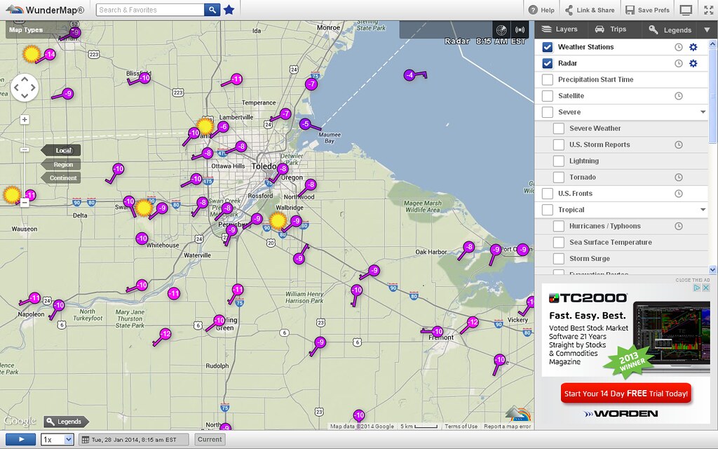
8:15 a.m., Tue, Jan 28, 2014 - http://wunderground.com/wundermap
2:50 p.m. Forecast.io info
From JR's : articles
3139 words - 18988 chars
- 17 min read
created on
updated on
- #
source
- versions
Related articles
Severe weather threat for Sun, Nov 17, 2013 - Nov 18, 2013
Nov 17, 2013 Toledo area weather notes - Mar 03, 2014
Posts related to Nov 17, 2013 severe weather - Nov 21, 2013
Toledo area weather for early December 2013 - Dec 05, 2013
Mon, Dec 9, 2013 winter storm forecast for Sat, Dec 14 - Dec 14, 2013
more >>