Toledo Weather - Mon, Feb 3, 2014
Morning sky is clear or mostly clear. Sunny but cold start with temps around 10 to 12 degrees at 8:00 a.m.
Toledo Express Airport
Feb 3, 2014 7:52 am
Weather : Fair
Temperature : 10 F
Humidity : 87%
Wind Speed : Calm
Barometer : 30.29 in
Dewpoint: 7 F
Visibility : 10.00 statute miles
Toledo Executive Airport
(formerly Metcalf Airport)
Feb 3, 2014 7:53 am
Weather : Fair with Haze
Temperature : 12 F
Humidity : 80%
Wind Speed : N 5 mph
Barometer : 30.30 in
Dewpoint: 7 F
Visibility : 6.00 statute miles
Wind Chill : 4 F
Toledo Suburban Airport
(near Lambertville)
Feb 3, 2014 8:35 am
Weather : Fair
Temperature : 10 F
Humidity : 85%
Wind Speed : Calm
Barometer : 30.31 in
Dewpoint: 7 F
Visibility : 7.00 statute miles
urgent - winter weather message
national weather service cleveland oh
319 am est mon feb 3 2014
ohz003-006>008-017-018-027-028-036-037-047-031630-
/o.new.kcle.ws.a.0003.140204t2200z-140205t1700z/
lucas-wood-ottawa-sandusky-hancock-seneca-wyandot-crawford-marion-
morrow-knox-
including the cities of...toledo...bowling green...port clinton...
fremont...findlay...tiffin...upper sandusky...carey...bucyrus...
marion...mount gilead...mount vernon
319 am est mon feb 3 2014
...winter storm watch in effect from tuesday afternoon through
wednesday morning...
the national weather service in cleveland has issued a winter
storm watch...which is in effect from tuesday afternoon through
wednesday morning.
- accumulations...total of 6 to 10 inches possible.
- timing...late tuesday through noon wednesday.
- winds...northeast to north 10 to 20 mph.
- temperatures...mostly in a range from 20 to 25.
- visibilities...down to a quarter of a mile at times.
- impacts...snow covered roads will make driving slow and
hazardous.
precautionary/preparedness actions...
a winter storm watch means that heavy snow is possible. if you
are within the watch area...remain alert to rapidly changing
weather conditions. stay tuned to the national weather service or
the local news media for the latest updates and possible
warnings.
Toledo 7-day forecast
Last Update: Feb 3, 2014 6:05 am
Today: Mostly sunny, with a high near 21. North wind around 5 mph becoming calm in the afternoon.
Tonight: Partly cloudy, with a low around 9. Calm wind.
Tuesday: A chance of snow, mainly after 5pm. Mostly cloudy, with a high near 24. Calm wind becoming northeast around 6 mph in the afternoon. Chance of precipitation is 30%. Little or no snow accumulation expected.
Tuesday Night: Snow, mainly after 8pm. Low around 18. Northeast wind 8 to 15 mph. Chance of precipitation is 100%.
Wednesday: Snow likely, mainly before 1pm. Cloudy, with a high near 24. North wind 10 to 16 mph. Chance of precipitation is 70%.
Wednesday Night: Mostly cloudy, with a low around 4.
Thursday: Mostly sunny, with a high near 15.
Thursday Night: Mostly cloudy, with a low around 2.
Friday: Partly sunny, with a high near 20.
Friday Night: Mostly cloudy, with a low around 5.
Saturday: A chance of snow. Mostly cloudy, with a high near 24. Chance of precipitation is 40%.
Saturday Night: A chance of snow. Mostly cloudy, with a low around 10. Chance of precipitation is 30%.
Sunday: A chance of snow. Mostly cloudy, with a high near 26. Chance of precipitation is 30%.
fxus61 kcle 031125
afdcle
area forecast discussion
national weather service cleveland oh
625 am est mon feb 3 2014
synopsis...
high pressure over the area will recede north to allow a low to move
from texas northeast across west virginia early wednesday then off
the new england coast later wednesday. high pressure over the plains
will spread east over ohio thursday then weaken saturday as another
low moves northeast across the virginias sunday.
&&
near term /through tonight/...
a weak upper s/w moving from tn thru the virginias could produce
some flurries or light snow over the se fringe of the cwa this
morning. high pressure moving over the area from the west will
continue to push drier air over the area and should lead to
decreasing clouds from west to east today.
temps will remain colder than normal with highs mostly in the low to
mid 20s.
&&
short term /tuesday through wednesday night/...
the big concern thru wed night will be the track of a low that moves
from east tx ne into wv by wed morning before quickly shifting off
the new england coast by later wed. the track of the low should stay
just far enough se of the area to keep the precip as snow. the track
should also put the cwa in the sweet spot for the heavier snow band
on the nw side of the track of the low. the snow may start late in
the day tue in the far west then quickly spread east over the rest
of the area the first half of tue night. the heavier snow should
taper off by wed morning as the better energy with the system shifts
ene of the area. however...deep moisture lingers over the area thru
the day wed and some lake enhancement may start to occur by
afternoon.
the potential for 6 to 10 inches exists with this system so will go
ahead and put up a winter storm watch starting late tue in the west
and run it thru about noon on wed in the west and 4 pm in the east.
&&
long term /thursday through sunday/...
high pressure will build across the ohio valley and lower great
lakes region thursday into friday. saturday through sunday models
bring an upper low across the southern plains into the lower
mississippi valley. the ecmwf weakens the upper system while the
gfs closes off the low and moves it up the east coast. meanwhile at
the surface both models develop low pressure and move it from the
nrn glfmx up the east coast however timing is different with the
ecmwf faster with the system. at this time will side toward an
hpc/ecmwf mix with chance pops saturday through sunday.
&&
aviation /12z monday through friday/...
high pressure and drier air will begin to build in from the west
this morning with further improvement to vfr this afternoon from
the west as high pressure gradually moves over the area.
outlook...non vfr in snow late tuesday into wednesday.
&&
marine...
high pressure will build across the lake today and tonight. the high
will weaken tuesday in advance of a storm system that will move
northeast across eastern ohio and western pa tuesday night and early
wednesday. thursday and friday high pressure will build east across
the ohio valley and lake erie. expect generally light northerly
winds on the lake today turning northeast early tuesday. northeast
winds will increase to 15 to 25 knots tuesday night turning
northwest wednesday as the low passes to the southeast of the lake.
winds will decrease to 10 to 15 knots wednesday night and thursday
as they back to west. winds will back further to southwest
friday. no marine headlines expected. through the period.
&&
cle watches/warnings/advisories...
oh...winter storm watch from tuesday evening through wednesday
afternoon for ohz009>014-019>023-029>033-038-089.
winter storm watch from tuesday afternoon through wednesday
morning for ohz003-006>008-017-018-027-028-036-037-047.
pa...winter storm watch from tuesday evening through wednesday
afternoon for paz001>003.
marine...none.
Forecast.io Toledo hi-lo temp predictions as of this morning, Feb 3, 2014:
Today, Feb 3 : 21 and 8
Tue, Feb 4 : 23 and 7
Wed, Feb 5 : 26 and 12
Thu, Feb 6 : 14 and 1
Fri, Feb 7 : 14 and -2
Sat, Feb 8 : 20 and 0
Sun, Feb 9 : 24 and 14
Mon, Feb 10 : 23 and 12
I can't answer for airline scheduling dynamics, but here's some info about snowfall forecasts.
At the moment, Toledo is on the northern edge of the 6- to 8-inch snowfall forecast area. It appears that areas to the south and east of us will get more snow, and the further north you go, such as the Detroit area, less snow is forecast. But a problem for drivers will be the wind and the blowing snow.
As of 11:00 a.m., a Winter Storm Watch exists for Lucas, Fulton, and Hillsdale counties but not for Lenawee, Monroe, and Wayne counties.
Currently, the forecast for the Detroit area:
Tuesday Night: Snow after 7pm. Low around 18. Northeast wind 6 to 11 mph increasing to 12 to 17 mph after midnight. Winds could gust as high as 20 mph. Chance of precipitation is 100%. New snow accumulation of 2 to 4 inches possible.
Wednesday: Snow showers before 1pm. High near 26. Blustery, with a north wind 11 to 20 mph, with gusts as high as 24 mph. Chance of precipitation is 90%. New snow accumulation of 1 to 2 inches possible.
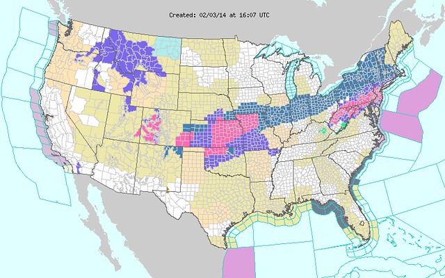
Map of weather statements at weather.gov.
The large swath of blue through Indiana and Ohio indicates counties that are under a Winter Storm Watch.
The white areas in southeast Michigan means no weather statements have been issued.
urgent - winter weather message
national weather service cleveland oh
316 pm est mon feb 3 2014
ohz003-006>008-017-018-027-028-036-037-047-040430-
/o.upg.kcle.ws.a.0003.140204t2200z-140205t1700z/
/o.new.kcle.ws.w.0003.140205t0000z-140205t2200z/
lucas-wood-ottawa-sandusky-hancock-seneca-wyandot-crawford-marion-
morrow-knox-
including the cities of...toledo...bowling green...port clinton...
fremont...findlay...tiffin...upper sandusky...carey...bucyrus...
marion...mount gilead...mount vernon
316 pm est mon feb 3 2014
...winter storm warning in effect from 7 pm tuesday to 5 pm est
wednesday...
the national weather service in cleveland has issued a winter
storm warning for snow...which is in effect from 7 pm tuesday to
5 pm est wednesday. the winter storm watch is no longer in
effect.
- accumulations...total of 6 to 8 inches possible.
- timing...tuesday evening through noon wednesday.
- winds...northeast to north 10 to 20 mph increasing to 15 to 25
mph wednesday morning.
- temperatures...will range from 20 to 25 degrees.
- visibilities...down to a quarter of a mile at times.
- impacts...snow covered roads will make driving slow and
hazardous. some blowing and drifting snow could also make travel
difficult.
- timing...the snow will begin to fall late tuesday afternoon but
the heavy snow is expected to arrive between 7 pm and 9 pm
across the area from southwest to northeast.
precautionary/preparedness actions...
a winter storm warning is issued when severe winter weather is
expected. heavy snow and/or ice will cause hazardous driving
conditions. if you will be traveling in the warning area you
should choose an alternate route if possible, or you should use
extreme caution if travel is unavoidable. stay tuned to noaa
weather radio or your favorite weather source for further details
or updates from the national weather service.
xus61 kcle 040218
afdcle
area forecast discussion
national weather service cleveland oh
918 pm est mon feb 3 2014
synopsis...
high pressure will move east across the area tonight. low pressure
developing over southern texas will move rapidly northeast up the
ohio river by wednesday morning and then to the northern new jersey
coast by wednesday afternoon. a ridge of high pressure will build
east across the area wednesday night through thursday followed by
high pressure on friday.
&&
near term /until 6 am tuesday morning/...
tweaked temps and clouds slightly...no significant changes for 930
update.
original discussion...
the calm before the storm will continue tonight as weak lazy high
pressure moves gradually east by tuesday afternoon. the high and its
associated dry air mass will keep the weather fair through the
night. this will mean generally clear skies through the night and
light winds. excellent radiational cooling will take place allowing
temperatures to drop to between 9 and 11 degrees for lows tonight
with some isolated lower single digits in the normally colder spots.
during the night...potent little vorticity maximum will gather
strength across the deep south of texas and associated trough will
become negatively tilted. this will cause rapid cyclogenesis to take
place and surface low will begin to intensify.
&&
short term /6 am tuesday morning through thursday night/...
here we go. the week long wait for the storm is finally upon us. the
gfs and european models have been very consistent with the track of
the storm system up the ohio river to the northeast. the nam model
is trending toward this solution as well. a potent upper level
trough over southern texas will track northeast and become
negatively tilted in response to a potent positive vorticity
maximum. as this feature moves northeast toward the area...rapid
cyclogenesis will take place at the surface and the resultant low
will move northeast into the forecast area.
the one thing that i see a change in the models compared to previous
runs is the development of a low pressure system along the new
jersey coast by wednesday. as of right now...the northeastward
moving storm system still looks like it will have enough punch to
give us significant snow accumulations tuesday night into wednesday
morning. however...if the coastal low becomes the dominant storm
very rapidly by wednesday morning...the flow of moisture could be
shunted to the east coast cutting off our moisture supply and bring
an end to the precipitation fairly quickly on wednesday. this
portion still has to be watched over the next 36 hours.
in the mean time...we think the snow will begin to spread into the
western portions of the forecast area during the late afternoon and
the rest of the forecast area in the evening. the snow should start
off light and it is anticipated the afternoon rush hour could get
through without too many problems. the timing of the heavy snow
looks like it should reach a line from toledo and findlay around 7
pm...cleveland to mansfield by 9 pm and then to erie and youngstown
by 11 pm in the evening. as the gradient associated with the storm
system increases...expecting winds to increase as well. 925 mb winds
will reach around 30 knots tuesday night into wednesday morning with
sustained winds of 15 to 20 mph. i think we will see some occasional
wind gusts to 30 mph at times. with the snow falling and the
wind...we could see some considerable blowing and drifting of the
snow making travel by the morning rush hour a real mess.
models are still hinting at some wrap around moisture wednesday
morning and as flow becomes more northerly we could see a semi multi
lake fetch and synoptic snow across the area for some left over snow
accumulations.
snow will gradually pull out for sure wednesday night and a return
back to fair weather is expected for thursday and thursday night.
high pressure ridge is expected to build east across the region and
push some drier air into the forecast area. winds should diminish as
well as weaker gradient moves into the area.
&&
long term /friday through monday/...
the week will end with a ridge of high pressure draped across the
upper ohio valley keeping the weather dry. temps will continue
below normal. a lot of differences exist in the long range models
but it appears that another low will move from the se states up the
east coast. some light precip from this system could make its way
into the area. the previous package already had small chance pops
from saturday night into sunday evening. this seems reasonable and
have only made minor changes. for those wanting warmer
weather...you will have to wait a while longer as high temps will
continue to average at least 10 degrees below normal during the
period.
&&
aviation /00z tuesday through saturday/...
high pressure will move across the forecast area tonight with light
winds and some increasing cirrus. on the edge about whether any
fog will form. continued the forecast of 3sm br at the typical
inland sites with the temperature dew point spread low. the hrrr
model is trying to forecast dense fog over northwest ohio. at this
time not buying that since not that much snow melted today and the
dew points are and will continue to be below freezing.
clouds will continue to thicken and lower on tuesday ahead of the
next weather maker. the timing of when the snow will start is
still in question. it will definitely be snowing by late tuesday
night. hopefully will be able to refine the timing of the snow
with the 06z tafs.
outlook...non vfr in snow late tuesday night into wednesday and
then again on saturday.
&&
marine...
quiet weather will continue a while longer on the lake before low
pressure passes to the se on tuesday night. light ne flow will
become nw behind the low. ridging will occur the second half of the
week with the flow mainly westerly. the ice remains mostly ice
covered but some shifting in the existing ice fields is likely.
&&
cle watches/warnings/advisories...
oh...winter storm warning from 7 pm tuesday to 5 pm est wednesday
for ohz003-006>014-017>023-027>033-036>038-047-089.
pa...winter storm warning from 7 pm tuesday to 5 pm est wednesday
for paz001>003.
marine...none.
&&
$$
synopsis...lombardy
near term...djb/lombardy
short term...lombardy
long term...kubina
aviation...kieltyka
marine...kubina
Toledo 7-day forecast
Last Update: Feb 3, 2014 9:07 pm
Overnight: Partly cloudy, with a low around 7. Wind chill values as low as -2. Calm wind.
Tuesday: A chance of snow, mainly after 5pm. Increasing clouds, with a high near 24. Wind chill values as low as -2. Calm wind becoming east 5 to 8 mph in the afternoon. Chance of precipitation is 30%. New snow accumulation of less than a half inch possible.
Tuesday Night: Snow, mainly after 8pm. Low around 19. Blustery, with a northeast wind 10 to 20 mph. Chance of precipitation is 100%. New snow accumulation of 3 to 7 inches possible.
Wednesday: Snow likely, mainly before 1pm. Cloudy, with a high near 26. Blustery, with a north wind 14 to 22 mph. Chance of precipitation is 70%.
Wednesday Night: Mostly cloudy, with a low around 6. Northwest wind 6 to 10 mph.
Thursday: Partly sunny, with a high near 17.
Thursday Night: Mostly cloudy, with a low around 1.
Friday: Partly sunny, with a high near 15.
Friday Night: Mostly cloudy, with a low around 6.
Saturday: A chance of snow. Cloudy, with a high near 22. Chance of precipitation is 40%.
Saturday Night: A chance of snow. Mostly cloudy, with a low around 16. Chance of precipitation is 40%.
Sunday: A chance of snow. Mostly cloudy, with a high near 23. Chance of precipitation is 30%.
Sunday Night: Mostly cloudy, with a low around 8.
Monday: Partly sunny, with a high near 19.
The Northern Indiana NWS office, which covers Fulton and Henry counties, has not issued any warnings yet.
Excerpts from the Monday evening area forecast discussion, issued by the Detroit/Pontiac NWS office, which covers Lenawee and Monroe counties:
3 to 6 inches expected from the m-59 corridor south. with models giving good support for 6 inches or less within a 12 hour period...this is looking right now like an advisory level event (and only for the southern half of the forecast area).
Excerpts from the Monday evening area forecast discussion, issued by the Cleveland NWS office, which covers Lucas, Wood, and Ottawa counties:
we think the snow will begin to spread into the western portions of the forecast area during the late afternoon [Tuesday].the timing of the heavy snow looks like it should reach a line from toledo and findlay around 7 pm.
sustained winds of 15 to 20 mph. i think we will see some occasional wind gusts to 30 mph at times. with the snow falling and the wind...we could see some considerable blowing and drifting of the snow making travel by the [Wednesday] morning rush hour a real mess.
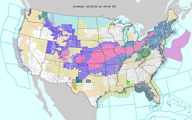
The purple through Ohio and Indiana indicates the Winter Storm Warnings, and the blue in extreme northwest Ohio and northern Indiana indicates Winter Storm Watches.
From JR's : articles
3231 words - 19726 chars
- 17 min read
created on
updated on
- #
source
- versions
Related articles
Severe weather threat for Sun, Nov 17, 2013 - Nov 18, 2013
Nov 17, 2013 Toledo area weather notes - Mar 03, 2014
Posts related to Nov 17, 2013 severe weather - Nov 21, 2013
Toledo area weather for early December 2013 - Dec 05, 2013
Mon, Dec 9, 2013 winter storm forecast for Sat, Dec 14 - Dec 14, 2013
more >>