Toledo Weather - Tue, Feb 4, 2014
hazardous weather outlook
national weather service cleveland oh
403 am est tue feb 4 2014
ohz003-006>009-017>019-027>030-036-037-047-050915-
lucas-wood-ottawa-sandusky-erie oh-hancock-seneca-huron-wyandot-
crawford-richland-ashland-marion-morrow-knox-
403 am est tue feb 4 2014
...winter storm warning in effect from 5 pm this afternoon to 5 pm
est wednesday...
this hazardous weather outlook is for north central ohio and
northwest ohio.
.day one...today and tonight.
please listen to noaa weather radio or go to weather.gov on the
internet for more information about the following hazards.
winter storm warning.
.days two through seven...wednesday through monday.
please listen to noaa weather radio or go to weather.gov on the
internet for more information about the following hazards.
winter storm warning.
.spotter information statement...
spotter activation is not expected at this time.
urgent - winter weather message
national weather service cleveland oh
322 am est tue feb 4 2014
ohz003-006>009-017>019-027>030-036-037-047-041630-
/o.ext.kcle.ws.w.0003.140204t2200z-140205t2200z/
lucas-wood-ottawa-sandusky-erie oh-hancock-seneca-huron-wyandot-
crawford-richland-ashland-marion-morrow-knox-
including the cities of...toledo...bowling green...port clinton...
fremont...sandusky...findlay...tiffin...norwalk...
upper sandusky...carey...bucyrus...mansfield...ashland...marion...
mount gilead...mount vernon
322 am est tue feb 4 2014
...winter storm warning now in effect from 5 pm this afternoon to
5 pm est wednesday...
- accumulations...total of 6 to 9 inches likely.
- timing...late today into wednesday afternoon.
- winds...northeast to north 10 to 20 mph increasing to 15 to 25
mph by wednesday morning.
- temperatures...will range from the low to mid 20s.
- visibilities...down to a quarter of a mile at times.
- impacts...snow covered roads will make driving slow and
hazardous. some blowing and drifting snow could make travel
difficult.
precautionary/preparedness actions...
you should use extreme caution if travel is unavoidable. stay
tuned to noaa weather radio or your favorite weather source for
further details or updates from the national weather service.
Toledo 7-day forecast
Last Update: Feb 4, 2014 6:07 am
Today: A chance of snow, mainly after 5pm. Mostly cloudy, with a high near 24. Calm wind becoming northeast around 6 mph in the afternoon. Chance of precipitation is 30%. Total daytime snow accumulation of less than a half inch possible.
Tonight: Snow, mainly after 8pm. Low around 18. Northeast wind 8 to 13 mph. Chance of precipitation is 100%. New snow accumulation of 3 to 7 inches possible.
Wednesday: Snow, mainly before 3pm. High near 25. North wind 11 to 15 mph. Chance of precipitation is 80%. New snow accumulation of 1 to 3 inches possible.
Wednesday Night: A chance of snow, mainly before 7pm. Mostly cloudy, with a low around 5. Wind chill values as low as -3. Northwest wind 6 to 9 mph. Chance of precipitation is 30%.
Thursday: Partly sunny, with a high near 17. West wind 7 to 13 mph.
Thursday Night: Mostly cloudy, with a low around 0.
Friday: Partly sunny, with a high near 17.
Friday Night: A chance of snow. Mostly cloudy, with a low around 2. Chance of precipitation is 30%.
Saturday: A chance of snow. Mostly cloudy, with a high near 22. Chance of precipitation is 30%.
Saturday Night: A chance of snow. Cloudy, with a low around 9. Chance of precipitation is 30%.
Sunday: A chance of snow. Mostly cloudy, with a high near 23. Chance of precipitation is 30%.
Sunday Night: A chance of snow. Mostly cloudy, with a low around 10. Chance of precipitation is 30%.
Monday: Mostly sunny, with a high near 23.
fxus61 kcle 041129
afdcle
area forecast discussion
national weather service cleveland oh
629 am est tue feb 4 2014
synopsis...
a low will track northeast from the gulf into west virginia by
daybreak wednesday then off the new england coast by evening. high
pressure will spread east across ohio thursday into thursday night
then shift north friday. another low will move out of the gulf and
track across virginia late sunday and off of new england by early
monday.
&&
near term /through tonight/...
for the most part...things look on track for snow to begin to spread
ene across the west half of the cwa by 00z this eve. the ongoing
forecast looks reasonable so just minor adjustments to pops.
after cold morning lows...temps today should be able to recover back
into the mid to upper 20s. the warmer readings will be in the east
where the clouds will be slower to thicken.
&&
short term /wednesday through friday night/...
the nam lifts the low a little further nw than the gfs bringing
somewhat warmer air into mahoning and nearby co's which could cause
some mixing of wintry precip to occur but the gfs keeps it cold
enough aloft for just snow. for now will maintain consistency and
stay with just snow. the day shift can see which way the 12z model
runs go and make adjustments to precip type and accumulation if
necessary.
it still looks like about 4 to 6 inches of snow tonight and another
1 to 3 inches on wed with the 3 inches more likely for the ne part
of the cwa. in order to maintain continuity...will leave winter
storm headlines as is with this forecast package except to start
warning in the west at 22z and in the east at 01z.
moisture hangs around wed night into thu with marginal lake
enhancement conditions present. will increase pops some for wed
night and thu for the snowbelt where some areas could see another
inch or two of additional accumulation.
arctic air is again pulled down over the area late wed and wed night
in the wake of the departing low. lows of 5 to 10 degrees seem
likely for wed night except the lakeshore of the snowbelt will
probably hang up in a 10 to 13 degree range due to more cloud cover.
thu remains cold with highs likely to stay in the teens. high
pressure moves over the area for thu night to calm the winds so thu
night should be the coldest night with lows close to zero for much
of the cwa.
think the high will maintain dry conditions thu night into early fri
night. enough return moisture ahead of the next system shows up by
the end of fri night to warrant at least small chance pops for
mainly the west half by the end of fri night.
&&
long term /saturday through monday/...
the long term begins saturday with models showing high pressure
across the ohio valley. aloft heights show a broad upper trof
across the states and the airmass across the region will be moist.
with little forcing however will keep pops at low chance category.
sunday models out of phase however both the ecmwf and gfs show a
developing upper trof moving through the great lakes while a surface
low moves up the east coast. will need to watch the evolution of
this system but the current model runs are not quite as aggressive
in developing the storm as previous runs. still both models indicate
the potential for moisture getting into the area sunday associated
either with the surface low or the upper trof so will have higher
chance pops and favor the east half. sunday night and monday high
pressure builds across the area along with decreasing moisture.
&&
aviation /12z tuesday through saturday/...
significant winter storm set to move into the area mostly after
00z this evening. until then expect vfr conditions although cigs
will be lowering as moisture increases. brought mvfr into the west
around 23z dropping to ifr and below 02-04z time frame. at kcle
brought mvfr conditions in by 02z with ifr after 04z. for the
overnight expect moderate to occasionally heavy snow across the
area. ifr to persist into wednesday morning.
outlook...non vfr wednesday and then again on saturday.
&&
marine...
low pressure will pass southeast of the lake tuesday night and early
wednesday before moving off the delmarva/new england coast
wednesday afternoon. ahead of the storm...winds will be from the
northeast today...backing to northwest by wednesday afternoon.
strongest flow will be late tuesday night and early wednesday at 20
to 25 knots. northwest flow will back to westerly by thursday
morning and then southwest thursday afternoon as high pressure
builds into the lower ohio valley from the west. winds will remain
from the southwest at 10 to 20 knots friday and then drop off
saturday to around 10 knots as the high builds over the lake. no
headlines expected.
&&
cle watches/warnings/advisories...
oh...winter storm warning from 8 pm this evening to 5 pm est
wednesday for ohz010>014-020>023-031>033-038-089.
winter storm warning from 5 pm this afternoon to 5 pm est
wednesday for ohz003-006>009-017>019-027>030-036-037-047.
pa...winter storm warning from 8 pm this evening to 5 pm est
wednesday for paz001>003.
marine...none.
&&
$$
synopsis...adams
near term...adams
short term...adams
long term...tk
aviation...tk
marine...tk
Forecast.io hi-lo Toledo temp predictions as of 9:48 a.m., on Tue, Feb 4, 2014:
- today, Feb 4 : 23 and 7
- Wed, Feb 5 : 27 and 10
- Thu, Feb 6 : 11 and -3
- Fri, Feb 7 : 11 and -6
- Sat, Feb 8 : 19 and -5
- Sun, Feb 9 : 24 and 18
- Mon, Feb 10 : 19 and 7
- Tue, Feb 11 : 18 and 5
urgent - winter weather message
national weather service cleveland oh
332 pm est tue feb 4 2014
ohz003-006>009-017>019-027>030-036-037-047-050445-
/o.con.kcle.ws.w.0003.140204t2200z-140205t2200z/
lucas-wood-ottawa-sandusky-erie oh-hancock-seneca-huron-wyandot-
crawford-richland-ashland-marion-morrow-knox-
including the cities of...toledo...bowling green...port clinton...
fremont...sandusky...findlay...tiffin...norwalk...
upper sandusky...carey...bucyrus...mansfield...ashland...marion...
mount gilead...mount vernon
332 pm est tue feb 4 2014
...winter storm warning remains in effect until 5 pm est
wednesday...
- accumulations...total of 6 to 10 inches likely.
- timing...late today into wednesday afternoon.
- winds...northeast to north 10 to 20 mph increasing to 15 to 25
mph by wednesday morning.
- temperatures...will range from the low to mid 20s.
- visibilities...down to a quarter of a mile at times.
- impacts...snow covered roads will make driving slow and
hazardous. some blowing and drifting snow could make travel
difficult.
precautionary/preparedness actions...
you should use extreme caution if travel is unavoidable. stay
tuned to noaa weather radio or your favorite weather source for
further details or updates from the national weather service.
Toledo 7-day forecast
Last Update: Feb 4, 2014 3:36 pm
Late Afternoon: A chance of snow. Cloudy, with a high near 24. Northeast wind around 7 mph. Chance of precipitation is 30%. Total daytime snow accumulation of less than a half inch possible.
Tonight: Snow, mainly after 8pm. Low around 20. Northeast wind 8 to 14 mph. Chance of precipitation is 100%. New snow accumulation of 3 to 7 inches possible.
Wednesday: Snow, mainly before 3pm. High near 26. North wind 15 to 18 mph. Chance of precipitation is 80%. New snow accumulation of 1 to 3 inches possible.
Wednesday Night: A chance of snow, mainly before 7pm. Mostly cloudy, with a low around 9. Wind chill values as low as -2. North wind 7 to 10 mph becoming west after midnight. Chance of precipitation is 30%.
Thursday: Partly sunny, with a high near 14. West wind 9 to 11 mph.
Thursday Night: Mostly cloudy, with a low around -5.
Friday: Partly sunny, with a high near 14.
Friday Night: A chance of snow. Mostly cloudy, with a low around 1. Chance of precipitation is 30%.
Saturday: A chance of snow. Cloudy, with a high near 22. Chance of precipitation is 30%.
Saturday Night: A chance of snow. Cloudy, with a low around 10. Chance of precipitation is 30%.
Sunday: A chance of snow. Mostly cloudy, with a high near 21. Chance of precipitation is 30%.
Sunday Night: A chance of snow. Mostly cloudy, with a low around 4. Chance of precipitation is 30%.
Monday: Partly sunny, with a high near 20.
Monday Night: Mostly cloudy, with a low around 0.
Tuesday: Partly sunny, with a high near 21.
my comment in the winter weather discussion thread at ToledoTalk.com
The Storm Prediction Center issued a mesoscale discussion at 4:14 p.m. today, Feb 4 that barely includes the Toledo area.

Excerpts:
heavy snowfall will become common through 00z across srn/cntrl ind...and eventually into wrn/nrn oh.rates of 1-2 per inches per hr will become increasingly likely into the evening hrs /especially within concentrated snow bands/...affecting the indianapolis and dayton metro areas...as well as surrounding portions of srn/cntrl ind and w-cntrl/nwrn oh.
Toledo forecast issued at 3:36 p.m.
Tonight: Snow, mainly after 8pm. Low around 20. Northeast wind 8 to 14 mph. Chance of precipitation is 100%. New snow accumulation of 3 to 7 inches possible.
Wednesday: Snow, mainly before 3pm. High near 26. North wind 15 to 18 mph. Chance of precipitation is 80%. New snow accumulation of 1 to 3 inches possible.
I like that range: 4 to 10 inches. Sometimes, it's tough to pinpoint the forecast, even as the snow enters the area.
4 inches of snow at this point barely warrants the time to remove it.
I think the forecast means that Trilby, Toledo will receive 4 to 5 inches of snow, Viva, Toledo will receive 6 to 7 inches of snow, and Bowling Green will receive 8 to 9 inches of snow.
Screen shot of ToledoWX, taken on Tuesday afternoon, February 4, 2014:
Earlier, I overlooked mentioning this interesting nugget of info from this afternoon's area forecast discussion, issued by the Cleveland NWS:
... all snow and this includes the toledo and findlay area over to the cleveland area. there is the potential that these areas could see more snow than we are currently forecasting if the northeast flow down lake erie is enhanced by moisture flux from the lake.there are several significant cracks in the ice that should be significant for some reverse lake enhancement to develop overnight tonight. may need to up snow amounts in the northwest area.
fxus63 kdtx 042339
afddtx
area forecast discussion
national weather service detroit/pontiac mi
639 pm est tue feb 4 2014
aviation...
//discussion...
area of accumulating light snowfall will expand northward and across
all terminals 02z-04z in response to low pressure tracking through
the lower ohio valley. a steady light to moderate snow will persist
through the morning hours on wednesday. upstream trends continue to
suggest a rapid onset of ifr conditions accompanying the onset of
snow across the southern terminals. slower downward progression in
restrictions at mbs but with a periodic ifr condition expected
during the peak intensity. an increase in the gradient will allow
northeast winds to strengthen with time overnight. winds will then
gradually veer and turn gusty as the low pulls eastward on
wednesday.
for dtw...recent radar and observational trends across indiana
indicate an onset of light snow around 02z at the terminal. a
progressive drop of visibility to ifr will accompany this onset.
total accumulation in the 4 to 5 inch range as the snow tapers off
midday wednesday. gusty northerly winds will contribute to some
blowing of the snow early wednesday.
//dtw threshold threats...
* high confidence in ceiling below 5000 feet tonight and wednesday
* high confidence in snow as precipitation type.
&&
prev discussion...issued 338 pm est tue feb 4 2014
short term...through early wednesday
yet another winter system is on track to impact southeast michigan
tonight. a winter weather advisory is in effect from the i-69
corridor to the ohio border. as of 19z, water vapor shows a
well-defined wave progressing through texas with plenty of gulf
moisture being lifted northward into the lower great lakes in
advance of the wave. this system is generating precipitation from
the lower mississippi valley into missouri and illinois via
isentropic lift, and also deformation snow over nebraska and kansas.
the upper wave will deamplify somewhat as it shears from texas
through the ohio valley by 12z wednesday. nwp shows the associated
surface low moving from its current position along the gulf coast at
the tx/la border to about nashville by 06z and near the oh/wv/pa
border by 12z. thereafter, the cyclone weakens and reemerges to the
lee of the appalachians. current satellite and radar support model
depictions of our cwa being impacted by both isentropic lift early
tonight and a deformation pattern later, which will translate into
roughly a 15-18 hour snowfall (00z to 18z). it still appears the
better dynamics will stay south of the border, though this morning's
12z runs did exhibit a slight shift to the left with the low's
track, in association with a slightly deeper wave and overall
slightly stronger system. aiding the lift at the onset (00z to 06z)
will be favorable positioning in the right entrance region of an
intensifying 170kt+ jet whose axis will be over eastern
ontario/western quebec. diabatically-driven outflow ahead of
convection currently over the lower ms valley will aid in building
the downstream ridge somewhat and strengthening the jet.
there are a couple of aspects about this event that are less
impressive. one is the overall moisture quality with 850 mb mixing
ratios only reaching a maximum of 2.5 g/kg in the far south, and a
lack of supersaturation with respect to ice. another is the elevated
and small dgz with sub 600-mb temps staying aoa -10c for most of the
advisory area until 12z. the result will be snow ratios in the
9-10:1 range for the southern two tiers (where more qpf is forecast)
and slightly better ratios of 11-12:1 for the i-69 and m-59
corridors. models also show a dry slot affecting the region as the
vort max passes by after 06z, which will mark the transition to
deformation snow. the dry slot may result in a lull in snowfall
rates, but not an end to it as the dgz shifts lower in the column by
09z and becomes saturated with deformation providing the lift. snow
should taper off west to east in the 12z-18z time frame as the
forcing pulls off to the east. winds will also increase through the
event to 15-20 mph by 12z. the winds, coupled with lows in the low
teens, will support wind chills in the lower single digits by 12z.
long term...wednesday night through next tuesday
cold air will continue to pour into the area wednesday night behind
the cold front. a weak upper wave will also drop through the area
late wednesday night into thursday as it is guided around a larger
upper system over hudson bay. this system will help provide mostly
cloudy skies overnight and help limit radiational cooling over the
fresher snowpack. lows should become quite chilly again as h850
temps drop back down to between -16 and -18 c. this should provide
min temps in the single digits.
upper wave looks to track across the region quietly as models show
it able to bring in or tap little moisture. it will however bring a
reinforcing shot of cold air on thursday...holding max temps into
the teens. improved radiational cooling conditions overnight should
help temps bottom out near to below zero...as dome of cold air
remains over the region. this brings about the next weather concern.
west to southwest winds will increase over the central great lakes
thursday and friday as a strong dome of high pressure slides from
the central plains into the ohio valley...and low pressure drops
through hudson bay and northern ontario. wind chill values will
remain cold on thursday...maxing out in the low single digits before
plummeting thursday night/friday morning to between -10 and -20 f.
recovery on friday looks to only be back up to near 0 to slightly
below 0. will have watch the potential for another wind chill
advisory thursday night.
lake effect potential will need to be assessed on a day by day basis
given expanding ice cover forming on lake michigan. there is
potential for flurries or even light snow showers from late
wednesday night through thursday evening as low-level lapse rates
increase and flow turns westerly from off the lake.
high pressure will remain over southeast michigan through the first
half of the weekend. this high will bring dry conditions and cooler
temperatures through saturday with high temperatures in the mid
teens on saturday. the next system looks to arrive on saturday night
and lasting through most of sunday. while snow will possibly occur
on sunday...temperatures will also warm up slightly into the low 20s
on sunday. as far as snow goes...it is still a little too early and
confidence in this system is too low to estimate accumulation totals
at this time. high pressure and cold temperatures return once again
for the beginning of next week.
marine...
northeast winds will increase tonight as low pressure begins to lift
up towards the area...then turn to the north early wednesday as the
low tracks across the ohio valley and towards the east coast. gusts
will be highest over the southern portion of lake huron...reaching
up around 30 knots late tonight into wednesday. winds will become
fairly light again wednesday night as the low pulls away from the
area.
increased west to southwest winds are then expected thursday through
friday as low pressure drops down through northern ontario and
hudson bay...and a strong dome of high pressure builds over the
central plains and ohio valley. much colder air will also filter
into the region during this timeframe...but extensive ice cover will
help limit winds between 20 and 30 knots over lake huron...with
lower values over lake st clair and western lake erie.
&&
dtx watches/warnings/advisories...
mi...winter weather advisory...miz060-miz061-miz062-miz063-miz068-miz069-
miz070-miz075-miz076-miz082-miz083...until noon wednesday.
lake huron...none.
lake st clair...none.
mi waters of lake erie...none.
&&
$$
aviation.....mr
short term...dt
long term....hlo/rk
marine.......hlo
you can obtain your latest national weather service forecasts
online at www.weather.gov/detroit (all lower case).
Winter Weather Advisory exists for Monroe County.
Statement as of 3:35 PM EST on February 04, 2014:
light snow will begin late this evening and will peak in intensity between 2 am and 7 am for most of the area. The snow will diminish during Wednesday morning and end by noon.Total snow accumulation from this evening through noon Wednesday will be in the 3 to 6 inch range with the highest amounts near the Ohio border.
Winter Storm Warning exists for Lucas County.
Statement as of 3:32 PM EST on February 04, 2014
accumulations... total of 6 to 10 inches likely.Timing... late today into Wednesday afternoon.
Winds... northeast to north 10 to 20 mph increasing to 15 to 25
mph by Wednesday morning.Visibilities... down to a quarter of a mile at times.
So it seems that around 6 inches of snow will fall in Toledo, unless McCaskey's statement is correct, or the dreaded reverse lake enhancement kicks in.
I don't know what name the Weather Channel has given this storm, but I'll call it 'McCaskey.'
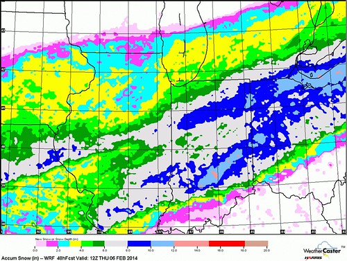
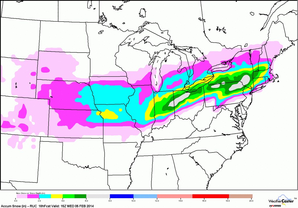
Here are screen captures of a couple images that JustaSooner has included at the top of this thread.
If I'm reading the images correctly, the first one indicates 4 to 5 inches of snowfall for Toledo by 10:00 a.m. Wednesday, which is a little bit before the snow is expected to end.
The second image indicates 10 to 12 inches of snowfall for Toledo by Thursday morning. I don't know.
The maps look pretty.

The most recent NWS forecast for the Toledo area has downgraded the total snowfall amounts a bit, or the forecast is now more specific. The previous forecast 6 to 10 inches has become 4 to 7 inches.
Toledo Forecast - Last Update: Feb 4, 2014 8:20 pm
Tonight: Snow. The snow could be heavy at times. Low around 19. Northeast wind 11 to 15 mph. Chance of precipitation is 100%. Total nighttime snow accumulation of 3 to 5 inches possible.
Wednesday: Snow, mainly before 2pm. High near 26. North wind 14 to 18 mph. Chance of precipitation is 100%. New snow accumulation of 1 to 2 inches possible.
urgent - winter weather message
national weather service cleveland oh
1055 pm est tue feb 4 2014
ohz003-006>009-017>019-027>030-036-037-047-051200-
/o.con.kcle.ws.w.0003.000000t0000z-140205t2200z/
lucas-wood-ottawa-sandusky-erie oh-hancock-seneca-huron-wyandot-
crawford-richland-ashland-marion-morrow-knox-
including the cities of...toledo...bowling green...port clinton...
fremont...sandusky...findlay...tiffin...norwalk...
upper sandusky...carey...bucyrus...mansfield...ashland...marion...
mount gilead...mount vernon
1055 pm est tue feb 4 2014
...winter storm warning remains in effect until 5 pm est
wednesday...
- accumulations...total of 6 to 8 inches...decreasing to 4 to 6
inches towards toledo.
- timing...the bulk of the snow fall overnight with an additional 1
to 2 inches on wednesday. snow will be heavy at times...
especially between midnight and 4 am.
- winds...northeast winds of 10 to 20 mph...shifting to north on
wednesday.
- temperatures...will range from the low to mid 20s.
- visibilities...will decrease into the early morning hours...occasionally
dropping to a quarter mile or less overnight.
- impacts...snow covered roads will make driving slow and
hazardous. some blowing and drifting of snow could make travel
difficult...especially on east to west oriented roads.
precautionary/preparedness actions...
you should use extreme caution if travel is unavoidable. stay
tuned to noaa weather radio or your favorite weather source for
further details or updates from the national weather service.
From JR's : articles
4088 words - 25724 chars
- 22 min read
created on
updated on
- #
source
- versions
Related articles
Severe weather threat for Sun, Nov 17, 2013 - Nov 18, 2013
Nov 17, 2013 Toledo area weather notes - Mar 03, 2014
Posts related to Nov 17, 2013 severe weather - Nov 21, 2013
Toledo area weather for early December 2013 - Dec 05, 2013
Mon, Dec 9, 2013 winter storm forecast for Sat, Dec 14 - Dec 14, 2013
more >>