Toledo Weather - Fri, Feb 7, 2014
8:00 a.m. Toledo temps were mainly minus-5 to minus-7 degrees. Mostly sunny start with orange ball shining.
urgent - winter weather message
national weather service cleveland oh
320 am est fri feb 7 2014
ohz003-006>009-017>019-027>030-036-037-047-071630-
/o.con.kcle.wc.y.0010.000000t0000z-140207t1700z/
lucas-wood-ottawa-sandusky-erie oh-hancock-seneca-huron-wyandot-
crawford-richland-ashland-marion-morrow-knox-
including the cities of...toledo...bowling green...port clinton...
fremont...sandusky...findlay...tiffin...norwalk...
upper sandusky...carey...bucyrus...mansfield...ashland...marion...
mount gilead...mount vernon
320 am est fri feb 7 2014
...wind chill advisory remains in effect until noon est today...
- wind chill readings...of 15 to 24 below zero this morning.
- winds...west to southwest winds of 10 to 15 mph.
- temperatures...five to ten degrees below zero this morning
rising to 5 to 10 degrees by noon.
- impacts...possible frostbite to exposed skin and hypothermia.
precautionary/preparedness actions...
if you will be outdoors use common sense and dress warmly...making
sure that all exposed skin is covered. avoid prolonged exposure
to the cold...if possible...to prevent frostbite and hypothermia.
stay tuned to weather radio for further details or updates.
hazardous weather outlook
national weather service cleveland oh
444 am est fri feb 7 2014
ohz003-006>014-017>023-027>033-036>038-047-089-paz001>003-080945-
lucas-wood-ottawa-sandusky-erie oh-lorain-cuyahoga-lake-geauga-
ashtabula inland-hancock-seneca-huron-medina-summit-portage-trumbull-
wyandot-crawford-richland-ashland-wayne-stark-mahoning-marion-morrow-
holmes-knox-ashtabula lakeshore-northern erie-southern erie-
crawford pa-
444 am est fri feb 7 2014
...wind chill advisory in effect until noon est today...
this hazardous weather outlook is for north central
ohio...northeast ohio...northwest ohio and northwest pennsylvania.
.day one...today and tonight.
please listen to noaa weather radio or go to weather.gov on the
internet for more information about the following hazards.
wind chill advisory.
.days two through seven...saturday through thursday.
another wind chill advisory may be needed friday night.
.spotter information statement...
spotter activation is not expected at this time.
Toledo Express Airport
Feb 7, 2014 7:52 am
Weather : Fair
Temperature : -7 F
Humidity : 82%
Wind Speed : SW 8 mph
Barometer : 30.35 in
Dewpoint: -11 F
Visibility : 10.00 statute miles
Wind Chill : -23 F
Toledo 7-day forecast
Last Update: Feb 7, 2014 3:02 am
Today: Sunny, with a high near 12. Wind chill values as low as -22. Southwest wind 11 to 15 mph.
Tonight: Partly cloudy, with a low around -2. Wind chill values as low as -14. Southwest wind 6 to 13 mph.
Saturday: A chance of snow, mainly after 3pm. Cloudy, with a high near 18. Wind chill values as low as -10. Calm wind becoming south 5 to 7 mph in the afternoon. Chance of precipitation is 30%. New snow accumulation of less than a half inch possible.
Saturday Night: Snow likely, mainly after 8pm. Cloudy, with a low around 10. Wind chill values as low as -1. Light and variable wind becoming east 5 to 7 mph after midnight. Chance of precipitation is 70%.
Sunday: Snow likely, mainly before 8am. Cloudy, with a high near 21. Northeast wind 7 to 9 mph becoming northwest in the afternoon. Chance of precipitation is 70%.
Sunday Night: A chance of snow before 8pm. Mostly cloudy, with a low around 5. Chance of precipitation is 30%.
Monday: Mostly sunny, with a high near 16.
Monday Night: Partly cloudy, with a low around -3.
Tuesday: Mostly sunny, with a high near 15.
Tuesday Night: Mostly cloudy, with a low around 4.
Wednesday: Mostly cloudy, with a high near 23.
Wednesday Night: Mostly cloudy, with a low around 13.
Thursday: Mostly cloudy, with a high near 28.
fxus61 kcle 071131
afdcle
area forecast discussion
national weather service cleveland oh
631 am est fri feb 7 2014
synopsis...
arctic high pressure over the mid mississippi valley will move
across the upper ohio valley today...and move off the east coast
saturday. this will allow a low pressure system to move across the
area saturday night into sunday.
&&
near term /until 6 pm this evening/...
clouds have cleared out over all but extreme ne oh and nw pa as
high pressure builds over the area. as the clouds have cleared
out temps have dipped into the negative single digits with wind
chills in the -15 to -25 degree range. those lucky enough to be
under the cloud cover have temps in the single digits with wind
chills between -10 and -15 degrees. temperatures will be slow to
rebound today as the arctic high...now centered over mid
mississippi valley...moves slowly over the area. models in good
agreement with high centered over forecast area by this evening.
of course only weather to contend with today will be a few
flurries over extreme ne oh and nw pa this morning.
&&
short term /6 pm this evening through monday night/...
temperatures tonight will hover near zero or a few degrees below but
with high centered over area not sure winds will be strong enough to
warrant a wind chill advisory. plus will see increasing clouds from
the west overnight.
the models continue to be in reasonably good agreement tracking a
weak low across the area sat night into sunday. timing continues
with snow reaching the west late saturday afternoon...then
spreading over the entire area saturday night. expect some
lingering snow in the east sunday morning. snow amounts should be
light...generally in the 1-3 inch range. expect some lake effect
snow showers in the snowbelt east of cleveland developing sunday
night.
temps should moderate some sat into sun but still staying below
normal then reinforcing arctic air should push temps back well below
normal for sunday and monday night.
&&
long term /tuesday through thursday/...
the forecast models trying to develop a similar solution for next
week's weather pattern. for tuesday look for partly to mostly cloudy
skies as the next weather disturbance approaches from the west. this
system will bring a chance of snow tuesday night and wednesday. some
lingering snow showers and flurries still in the area wednesday
night into thursday. more snow possibly for friday also.
temperatures below normal during the extended period.
&&
aviation /12z friday through tuesday/...
high pressure ridge will build into the region today with
west to southwest winds around 10 to 20 knots. winds to slowly
subside this afternoon.
a few pockets of cloud cover will gradually dissipate by early
this afternoon. a few flurries possible northeast ohio and
northwest pennsylvania.
outlook...non vfr redeveloping again on saturday continuing into
sunday and early monday.
&&
marine...
no headlines expected through the immediate forecast period. a
couple of weak systems will move swiftly across the lower great
lakes region and bring a chance of snow. the wind flow will
generally be southwest to west for most of the forecast period.
&&
cle watches/warnings/advisories...
oh...wind chill advisory until noon est today for ohz003-006>014-
017>023-027>033-036>038-047-089.
pa...wind chill advisory until noon est today for paz001>003.
marine...none.
&&
$$
synopsis...djb
near term...djb
short term...djb
long term...bc
aviation...mullen
marine...bc
Forecast.io Toledo hi and lo temp predictions:
- today, Fri, Feb 7 : 11 and -6
- Sat, Feb 8 : 18 and 0
- Sun, Feb 9 : 23 and 14
- Mon, Feb 10 : 19 and 5
- Tue, Feb 11 : 17 and -2
- Wed, Feb 12 : 25 and 5
- Thu, Feb 13 : 36 and 19
- Fri, Feb 14 : 34 and 20
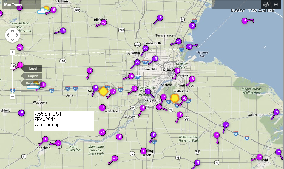
This morning's screen capture of http://wunderground.com/wundermap for the Toledo area at 7:55 a.m.
fzus51 kcle 120846
nshcle
nearshore marine forecast
national weather service cleveland oh
346 am est wed feb 12 2014
for waters within five nautical miles of shore on lake erie
lez142>149-121530-
maumee bay to reno beach oh-reno beach to the islands oh-
the islands to vermilion oh-vermilion to avon point oh-
avon point to willowick oh-willowick to geneva-on-the lake oh-geneva-
on-the-lake to conneaut oh-conneaut oh to ripley ny-
346 am est wed feb 12 2014
today...east winds less than 10 knots becoming southeast. sunny.
tonight...southeast winds 10 knots or less. partly cloudy.
thursday...east winds less than 10 knots. mostly sunny.
thursday night...south winds 10 knots or less becoming southwest
5 to 15 knots. mostly cloudy.
waves omitted due to the nearshore waters being mostly ice covered.
see lake erie open lakes forecast for friday through sunday.
the water temperature off toledo is 33 degrees...off cleveland 33
degrees and off erie 33 degrees.
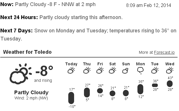
Forecast.io hi-lo Toledo temp predictions as of 8:02 a.m., Wed, Feb 12.
- Wed, Feb 12 : 17 and -10
- Thu, Feb 13 : 27 and 5
- Fri, Feb 14 : 26 and 14
- Sat, Feb 15 : 21 and 8
- Sun, Feb 16 : 21 and 8
- Mon, Feb 17 : 35 and 12 (NWS predicts 38)
- Tue, Feb 18 : 36 and 28 (NWS predicts 35)
- Wed, Feb 19 : 43 and 28
Our winter could "break" in mid-February, which is about right. In late February, we typically get some March spring weather. Sure, it could still snow in March, and it might with this winter. I was hoping we could maintain snow cover through February.
From JR's : articles
1443 words - 9269 chars
- 8 min read
created on
updated on
- #
source
- versions
Related articles
Severe weather threat for Sun, Nov 17, 2013 - Nov 18, 2013
Nov 17, 2013 Toledo area weather notes - Mar 03, 2014
Posts related to Nov 17, 2013 severe weather - Nov 21, 2013
Toledo area weather for early December 2013 - Dec 05, 2013
Mon, Dec 9, 2013 winter storm forecast for Sat, Dec 14 - Dec 14, 2013
more >>