You're viewing old version number 7. - Current version
Toledo Weather - Mon, Feb 17, 2014
urgent - winter weather message
national weather service cleveland oh
323 am est mon feb 17 2014
.an area of low pressure will develop over the central plains
today and then move northeast across western ohio and over lake
erie tonight. snow associated with this low will spread rapidly
east across the area this evening and then taper off from west to
east late tonight. some sleet or even some freezing rain could
briefly mix with the snow this evening south of the u.s. 30
corridor. very gusty winds will accompany the snow and cause
blowing and drifting.
ohz003-006>009-017>019-027>031-036>038-047-171630-
/o.new.kcle.ww.y.0010.140217t2200z-140218t0900z/
lucas-wood-ottawa-sandusky-erie oh-hancock-seneca-huron-wyandot-
crawford-richland-ashland-wayne-marion-morrow-holmes-knox-
including the cities of...toledo...bowling green...port clinton...
fremont...sandusky...findlay...tiffin...norwalk...
upper sandusky...carey...bucyrus...mansfield...ashland...
wooster...marion...mount gilead...millersburg...mount vernon
323 am est mon feb 17 2014
...winter weather advisory in effect from 5 pm this afternoon to
4 am est tuesday...
the national weather service in cleveland has issued a winter
weather advisory which is in effect from 5 pm this afternoon to 4
am est tuesday.
- accumulations...4 to 5 inches. a brief period of sleet or
freezing rain is possible at the southern end of the area.
- timing...the snow will spread across the area early this
evening. the snow should reach the i-75 corridor around 5 pm.
- winds...southeast winds increasing to 15 to 30 mph this
afternoon and then becoming southwest during the evening. gusts
to 40 mph are likely after midnight with locally higher gusts
closer to lake erie.
- impacts...snow accumulation can make roads slick...requiring
lower speeds and greater distances between vehicles while
driving.
- temperatures...upper 20s falling into the lower 20s.
- visibilities...less than one half mile at times.
precautionary/preparedness actions...
a winter weather advisory is normally issued for a variety of
winter weather conditions such as light snow, blowing snow,
sleet, freezing rain and wind chills. while the weather will be
significant, the word advisory implies that severe winter weather
is not anticipated. stay tuned to noaa weather radio for further
details or updates.
flus41 kcle 171027
hwocle
hazardous weather outlook
national weather service cleveland oh
527 am est mon feb 17 2014
ohz010>014-020>023-032-033-089-paz001>003-181030-
lorain-cuyahoga-lake-geauga-ashtabula inland-medina-summit-portage-
trumbull-stark-mahoning-ashtabula lakeshore-northern erie-
southern erie-crawford pa-
527 am est mon feb 17 2014
..winter weather advisory in effect from 7 pm this evening to 7 am
est tuesday...
this hazardous weather outlook is for north central
ohio...northeast ohio and northwest pennsylvania.
day one...today and tonight.
please listen to noaa weather radio or go to weather.gov on the
internet for more information about the following hazards.
winter weather advisory.
days two through seven...tuesday through sunday.
please listen to noaa weather radio or go to weather.gov on the
internet for more information about the following hazards.
winter weather advisory.
a warming trend is expected the second half of the week.
temperatures may top 50 degrees on thursday. rain combined with
snow melt may produce flooding...especially thursday into friday.
if heavy rain were to occur... significant flooding is possible.
ice jam flooding is also possible especially in the typical spots.
this would include the mouths of rivers emptying into lake erie.
ice would likely back up on the rivers due to ice cover on lake
erie.
spotter information statement...
spotter activation is not expected at this time.
Toledo Express Airport
Feb 17, 2014 4:52 am
Weather : Fair
Temperature : 4 F
Humidity : 88%
Wind Speed : E 5 mph
Barometer : 30.36 in
Dewpoint: 1 F
Visibility : 10.00 statute miles
Toledo Executive Airport
(formerly Metcalf Airport)
Feb 17, 2014 4:53 am
Weather : Fair
Temperature : -1 F
Humidity : 82%
Wind Speed : Calm
Barometer : 30.38 in
Dewpoint: -5 F
Visibility : 10.00 statute miles
(near Lambertville)
Feb 17, 2014 5:15 am
Weather : Fair
Temperature : 5 F
Humidity : 85%
Wind Speed : E 3 mph
Barometer : 30.38 in
Dewpoint: 1 F
Visibility : 10.00 statute miles
Wind Chill : -1 F
Toledo 7-day forecast
Last Update: Feb 17, 2014 3:11 am
Washington's Birthday: Snow likely, mainly after 4pm. Cloudy, with a high near 28. Wind chill values as low as zero. Light east wind increasing to 10 to 15 mph in the morning. Winds could gust as high as 25 mph. Chance of precipitation is 60%. Total daytime snow accumulation of around an inch possible.
Tonight: Snow, mainly before 3am. Low around 21. Breezy, with a south wind 5 to 10 mph becoming west 16 to 21 mph after midnight. Winds could gust as high as 31 mph. Chance of precipitation is 100%. New snow accumulation of 3 to 5 inches possible.
Tuesday: Mostly sunny, with a high near 37. Southwest wind 13 to 17 mph.
Tuesday Night: Partly cloudy, with a low around 28. Breezy, with a southwest wind 17 to 20 mph.
Wednesday: Partly sunny, with a high near 36. West wind 13 to 15 mph.
Wednesday Night: Mostly cloudy, with a low around 25.
Thursday: Snow likely before 1pm, then rain. High near 45. Chance of precipitation is 80%.
Thursday Night: Rain and snow likely. Mostly cloudy, with a low around 28. Chance of precipitation is 60%.
Friday: A slight chance of snow showers. Partly sunny, with a high near 38. Breezy.
Friday Night: Mostly cloudy, with a low around 25.
Saturday: A chance of rain and snow. Mostly cloudy, with a high near 36. Chance of precipitation is 30%.
Saturday Night: A chance of snow. Mostly cloudy, with a low around 21. Chance of precipitation is 30%.
Sunday: Mostly cloudy, with a high near 29.
fxus61 kcle 170844
afdcle
area forecast discussion
national weather service cleveland oh
344 am est mon feb 17 2014
synopsis...
high pressure over the eastern great lakes will shift to the east
coast today. this will allow low pressure over the central plains
to move northeast to western ohio this evening. this low will move
across lake erie tonight dragging a cold front across the local area.
another low will pass well to the north on tuesday night and drag another
front across the region. another very strong area of low pressure
will affect the area toward the end of the week.
&&
near term /through tonight/...
most of the area has cleared overnight allowing temps to plunge
into the single digits. the traditional cool spots will make a run
toward zero by daybreak. expect clouds to increase today as low
pressure takes shape over ok. the models now fairly similar in
moving this low into western ohio by evening. snow associated with
the low will arrive by the end of the today period in the west.
the snow will then spread across the remainder of the area this
evening reaching nw pa by 9 pm at the latest. per coordination
with neighboring offices have put up advisories for the entire
area. snowfall totals are expected to meet only minimal criteria
but increasing winds will add to the misery with a lot of blowing
and drifting. all of the guidance continues to show a brief window
for mixed precip along and south of the u.s. 30 corridor this
evening. main concern is for sleet but it is possible that some
freezing rain could occur across southern knox county. models also
show a dry slot moving in behind the low after midnight. this will
dry out the mid levels and later shifts will have to watch for
freezing drizzle for an hour or two before the wrap around snow
arrives. for the most part expecting a 6 to 9 hour window of snow.
by daybreak tuesday the western 2/3 to 3/4 of the area will be
dry. strong se flow will develop later today. locations near lake
erie across nw pa could end up with gusts near wind advisory
criteria this evening. have highlighted this potential in the
winter weather advisory. local schemes and rules of thumb
consistently showing around 4 inches of accum most areas. expect
maybe slightly higher amounts in far nw oh and nw pa. used a blend
of guidance temps.
&&
short term /tuesday through thursday night/...
an active pattern will continue during the period. a clipper will
move across the region tuesday night but moisture will be limited.
not expecting much if any precipitation but a brief window of
lake effect snow is possible wednesday over nw pa. the big story
later in the period is the expected warm up. low pressure will
lift over the western great lakes by the end of the period. strong
warm air advection will begin late wednesday and continue on
tuesday. surface dewpoints will climb into the 40s so good snow
melting will occur. rain associated with the low will arrive on
thursday with greatest amounts expected over nw oh. already have
high precip chances going and see no need for significant changes.
will continue to mention the flooding potential in the hazardous
weather outlook. expect that flood watches will eventually be
needed. have used a blend of guidance temps through the period.
&&
long term /friday through sunday/...
models are in decent agreement as a strong storm system pulls away
from the region on friday. after that the timing of jet energy
moving through the fast flow varies with each model. so with that
said we have made very few changes to the extended and will
hopefully see some model consistency over the next few days.
the one thing that is similar in the models is a cold front should
cross the area at some point saturday into sunday. this will cause
temperatures to drop back into the upper 20s to lower 30s. just not
sure which day/days will be the coldest.
&&
aviation /06z monday through friday/...
a ridge will move west to east across the region tonight and
monday morning. the lake effect clouds/flurries were continuing to
decrease. the big question is will some fog form. highs clouds
will be moving in overnight especially for the southern portion of
the forecast area. this may inhibit the fog some. mentioned fog in
the tafs especially close to the lakeshore and in the mansfield
area. in fact some stratus could come in off of lake erie into
toledo in the easterly flow. for monday any fog will burn off
quickly. the clouds will continue to thicken and lower. some
question how quickly the snow will come in. at this time leaning
toward the gfs timing which is early evening for nw ohio. the
snow should spread east quickly. the heaviest snow should be over
nw ohio with the low tracking across nw ohio. the southeast areas
could see a mix as plenty of warm air will come up in the strong
low level southwest flow.
outlook...non-vfr late monday night lasting into tuesday. non-vfr
likely redeveloping thursday and thursday night.
&&
marine...
active weather week expected with a couple strong storm systems
crossing the ice covered lake. as the low passes late tonight into
tuesday southwest to west winds will increase significantly. at this
point have kept 30 knots but will not be surprised if we end up
needing a gale warning after midnight into tuesday morning.
high pressure will then briefly ridge over the lake before the next
cold front crosses lake erie on wednesday. the next storm system
will move into the central great lakes thursday night with
increased southerly winds. this storm will deepen as it moves
northeast across ontario on friday with a cold front racing across
the region. strong cold advection with the westerly winds on friday
will again attempt to reach gale levels.
the strong winds and warmer temperatures should allow the ice to
begin to move around...especially thursday into friday.
&&
cle watches/warnings/advisories...
oh...winter weather advisory from 7 pm this evening to 7 am est
tuesday for ohz010>014-020>023-032-033-089.
winter weather advisory from 5 pm this afternoon to 4 am est
tuesday for ohz003-006>009-017>019-027>031-036>038-047.
pa...winter weather advisory from 7 pm this evening to 7 am est
tuesday for paz001>003.
marine...none.
fzus51 kcle 170843
nshcle
nearshore marine forecast
national weather service cleveland oh
343 am est mon feb 17 2014
for waters within five nautical miles of shore on lake erie
lez142>146-171515-
maumee bay to reno beach oh-reno beach to the islands oh-
the islands to vermilion oh-vermilion to avon point oh-
avon point to willowick oh-
343 am est mon feb 17 2014
today...east winds 10 knots or less becoming southeast and
increasing to 10 to 20 knots. partly sunny this morning...then
cloudy with a chance of snow this afternoon.
tonight...southeast winds 10 to 20 knots becoming west and
increasing to 30 knots. snow.
tuesday...west winds to 30 knots becoming southwest and diminishing
to 15 to 20 knots. mostly sunny. a chance of snow in the morning.
tuesday night...southwest winds 20 to 25 knots. partly cloudy.
waves omitted due to the nearshore waters being mostly ice covered.
see lake erie open lakes forecast for wednesday through friday.
the water temperature off toledo is 33 degrees...off cleveland 33
degrees and off erie 32 degrees.
$$
lez147>149-171515-
willowick to geneva-on-the lake oh-geneva-on-the-lake to conneaut oh-
conneaut oh to ripley ny-
343 am est mon feb 17 2014
today...east winds 10 knots or less increasing to 10 to 15 knots.
mostly sunny this morning...then becoming mostly cloudy.
tonight...southeast winds to 30 knots becoming south. snow.
tuesday...west winds to 30 knots becoming southwest. snow likely in
the morning.
tuesday night...south winds 15 to 25 knots becoming southwest.
partly cloudy.
waves omitted due to the nearshore waters being mostly ice covered.
see lake erie open lakes forecast for wednesday through friday.
the water temperature off toledo is 33 degrees...off cleveland 33
degrees and off erie 32 degrees.
forecast.io at 8am for toledo:
Now: Mostly Cloudy 4 F - ENE at 5 mph
Next 24 Hours: Windy starting tonight, continuing until tomorrow morning, with heavy snow (3–5 in) starting this afternoon, continuing until tomorrow morning.
Next 7 Days: Mixed precipitation off-and-on throughout the week; temperatures rising to 51° on Thursday.
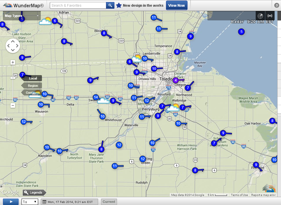
http://wunderground.com/wundermap
9:19 a.m. temps:
http://www.toledoblade.com/local/2014/02/17/More-snow-today-is-fuel-for-record.html
Toledo’s snowiest-winter was 73.1-inches in 1977-78.Sunday’s [Feb 16, 2014] snowfall added 0.9 inches at Toledo Express Airport, bringing the total since Dec. 1 to 67.8 inches, according to the National Weather Service.
February snowfall to date is 16.4 inches, or 10.7 inches above normal, the weather service said.
Three to five inches more are forecast for today.
Meanwhile, daytime temperatures will rise above freezing Tuesday through Friday; 37 on Tuesday and Wednesday’s forecast and 44 on Thursday, when heavy rain is expected. Friday’s high is forecast to be 35.
About one inch of new snow at TOL yest. I measured 1.5 inches here at home in West Toledo.
urgent - winter weather message
national weather service cleveland oh
912 am est mon feb 17 2014
.an area of low pressure will develop over the central plains
today and then move northeast across western ohio and over lake
erie tonight. snow associated with this low will spread rapidly
east across the area this evening and then taper off from west to
east late tonight. sleet or freezing rain may mix with the snow
this evening south of the u.s. 30 corridor.
ohz003-006>009-017>019-027>031-036>038-047-172215-
/o.con.kcle.ww.y.0010.140217t2200z-140218t0900z/
lucas-wood-ottawa-sandusky-erie oh-hancock-seneca-huron-wyandot-
crawford-richland-ashland-wayne-marion-morrow-holmes-knox-
including the cities of...toledo...bowling green...port clinton...
fremont...sandusky...findlay...tiffin...norwalk...
upper sandusky...carey...bucyrus...mansfield...ashland...
wooster...marion...mount gilead...millersburg...mount vernon
912 am est mon feb 17 2014
...winter weather advisory remains in effect from 5 pm this
afternoon to 4 am est tuesday...
- accumulations...4 to 5 inches. a brief period of sleet or
freezing rain is possible at the southern end of the area.
- timing...the snow will spread across the area early this
evening. the snow should reach the i-75 corridor around 5 pm.
- winds...southeast winds increasing to 15 to 30 mph this
afternoon and then becoming southwest during the evening.
gusts to 40 mph are likely after midnight with locally higher
gusts closer to lake erie.
- impacts...snow accumulation can make roads slick...requiring
lower speeds and greater distances between vehicles while
driving.
- temperatures...upper 20s falling into the lower 20s.
- visibilities...less than one half mile at times.
precautionary/preparedness actions...
a winter weather advisory is normally issued for a variety of
winter weather conditions such as light snow... blowing snow...
sleet... freezing rain and wind chills. while the weather will be
significant... the word advisory implies that severe winter
weather is not anticipated. stay tuned to noaa weather radio for
further details or updates.
Toledo 7-day forecast
Last Update: Feb 17, 2014 9:06 am
Washington's Birthday: Snow likely, mainly after 5pm. Cloudy, with a high near 28. East wind 11 to 15 mph, with gusts as high as 25 mph. Chance of precipitation is 60%. Total daytime snow accumulation of less than one inch possible.
Tonight: Snow, mainly before 4am. Low around 21. Breezy, with a south wind 5 to 10 mph becoming west 16 to 21 mph. Winds could gust as high as 31 mph. Chance of precipitation is 100%. New snow accumulation of 3 to 5 inches possible.
Tuesday: A slight chance of snow before 8am. Mostly sunny, with a high near 37. Southwest wind 13 to 17 mph. Chance of precipitation is 20%.
Tuesday Night: Partly cloudy, with a low around 28. Breezy, with a southwest wind 18 to 20 mph.
Wednesday: Partly sunny, with a high near 36. West wind 14 to 16 mph.
Wednesday Night: Mostly cloudy, with a low around 25.
Thursday: Snow likely between 8am and 2pm, then rain. High near 45. Chance of precipitation is 80%.
Thursday Night: Rain and snow. Low around 28. Chance of precipitation is 80%.
Friday: Rain and snow showers likely. Partly sunny, with a high near 38. Breezy. Chance of precipitation is 60%.
Friday Night: Mostly cloudy, with a low around 25.
Saturday: A chance of rain and snow. Mostly cloudy, with a high near 36. Chance of precipitation is 30%.
Saturday Night: A chance of rain and snow. Mostly cloudy, with a low around 21. Chance of precipitation is 30%.
Sunday: A chance of snow showers. Mostly cloudy, with a high near 29. Chance of precipitation is 30%.
Forecast.io Toledo hi-lo temp predictions as of 12:15 p.m.:
Now: Overcast 17 F - E at 9 mph
Next 24 Hours: Windy starting tonight, continuing until tomorrow morning, with heavy snow (3–4 in) starting later this afternoon, continuing until tomorrow morning.
Next 7 Days: Mixed precipitation off-and-on throughout the week; temperatures rising to 50° on Thursday.
- today, Mon, Feb 17 : 30 and 2
- Tue, Feb 18 : 36 and 22
- Wed, Feb 19 : 35 and 28
- Thu, Feb 20 : 50 and 27
- Fri, Feb 21 : 49 and 30
- Sat, Feb 22 : 40 and 25
- Sun, Feb 23 : 35 and 27
- Mon, Feb 24 : 29 and 21
A little west of us.

md 0110 concerning heavy snow for southern wi/northern il to west-central/northern indiana and southern lower mi
mesoscale discussion 0110
nws storm prediction center norman ok
1130 am cst mon feb 17 2014
areas affected...southern wi/northern il to west-central/northern
indiana and southern lower mi
concerning...heavy snow
valid 171730z - 172230z
summary...moderate to locally heavy snow will continue to develop
eastward this afternoon across the southern half of wi...much of
northern/parts of central il including the chicago metro area...into
northern/west-central indiana and southwest lower mi. with the
heaviest snow...rates will exceed 1+ in/hr for a couple hour
duration. additionally...some thunderstorms and mixed winter
precipitation including some sleet/freezing rain and snow will be
possible particularly across north-central/east-central il into
northwest indiana.
discussion...a progressive/modestly amplifying shortwave trough
centered over the lower mo river valley late this morning will
continue steadily eastward through the afternoon. progression of
this shortwave trough and associated dpva/warm advection and upper
jet exit region induced divergence will lead to a general eastward
spread of relatively strong uvv across the region this
afternoon...particularly across southern wi/lower mi and the
northern halves of il/indiana. similar to 12z observed
soundings...regional forecast soundings generally reflect ample uvv
coincident with a saturated mid-level dendritic layer supportive of
moderate/locally heavier snow for a multi-hour
duration...particularly given influences of weak elevated
instability especially across parts of il/indiana.
the 12z observed sounding from lincoln il sampled around 60 j/kg of
mucape based above 700 mb...with nearly 700 j/kg of mucape per 12z
springfield mo. especially given the proximity of the upper dry slot
as per water vapor imagery...available instability will continue to
support thundersnow and/or mixed precipitation in association with
thunderstorms such has been reported recently at champaign il /kcmi/
and is otherwise evident in radar/lightning network data across
central/parts of northeast il this morning.
..guyer.. 02/17/2014
...please see www.spc.noaa.gov for graphic product...
attn...wfo...iwx...grr...ind...grb...lot...ilx...mkx...dvn...
arx...
lat...lon 40489074 41919066 43709094 44178939 43838810 42988573
42048474 40868573 40168601 39138822 40098940 40489074
urgent - winter weather message
national weather service cleveland oh
305 pm est mon feb 17 2014
ohz003-006>009-017>019-027>031-036>038-047-180415-
/o.con.kcle.ww.y.0010.140217t2200z-140218t0900z/
lucas-wood-ottawa-sandusky-erie oh-hancock-seneca-huron-wyandot-
crawford-richland-ashland-wayne-marion-morrow-holmes-knox-
including the cities of...toledo...bowling green...port clinton...
fremont...sandusky...findlay...tiffin...norwalk...
upper sandusky...carey...bucyrus...mansfield...ashland...
wooster...marion...mount gilead...millersburg...mount vernon
305 pm est mon feb 17 2014
...winter weather advisory remains in effect until 4 am est
tuesday...
- accumulations...4 to 6 inches. some sleet or freezing rain is
possible for the southern part of the area.
- timing...the snow will rapidly spread across the area early this
evening then taper off late tonight.
- winds...southeast winds increasing to 15 to 25 mph and then
becoming southwest by late evening. gusts to 35 mph are likely
after midnight with locally higher gusts closer to lake erie.
- impacts...snow accumulation can make roads slick...requiring
lower speeds and greater distances between vehicles while
driving.
- temperatures...steady in the mid to upper 20s early then
falling into the lower 20s by the end of the night.
- visibilities...less than one half mile at times.
precautionary/preparedness actions...
a winter weather advisory is normally issued for a variety of
winter weather conditions such as light snow... blowing snow...
sleet... freezing rain and wind chills. while the weather will be
significant... the word advisory implies that severe winter
weather is not anticipated. stay tuned to noaa weather radio for
further details or updates.
From JR's : articles
3632 words - 23573 chars
- 20 min read
created on
updated on
- #
source
- versions
Related articles
Severe weather threat for Sun, Nov 17, 2013 - Nov 18, 2013
Nov 17, 2013 Toledo area weather notes - Mar 03, 2014
Posts related to Nov 17, 2013 severe weather - Nov 21, 2013
Toledo area weather for early December 2013 - Dec 05, 2013
Mon, Dec 9, 2013 winter storm forecast for Sat, Dec 14 - Dec 14, 2013
more >>