Toledo Weather - Mon, Feb 24, 2014
hazardous weather outlook
national weather service cleveland oh
450 am est mon feb 24 2014
ohz003-006>014-017>023-027>033-036>038-047-089-paz001>003-251000-
lucas-wood-ottawa-sandusky-erie oh-lorain-cuyahoga-lake-geauga-
ashtabula inland-hancock-seneca-huron-medina-summit-portage-trumbull-
wyandot-crawford-richland-ashland-wayne-stark-mahoning-marion-morrow-
holmes-knox-ashtabula lakeshore-northern erie-southern erie-
crawford pa-
450 am est mon feb 24 2014
this hazardous weather outlook is for north central
ohio...northeast ohio...northwest ohio and northwest pennsylvania.
.day one...today and tonight.
ice jam flooding will continue to be a threat along some rivers...
streams and creeks around the area.
.days two through seven...tuesday through sunday.
the threat of ice jam flooding will diminish by mid week as much
below normal temperatures return to the area and the ice refreezes.
.spotter information statement...
spotter activation is not expected at this time.
flood statement
national weather service cleveland oh
524 am est mon feb 24 2014
...the flood warning continues for the following rivers in ohio...
portage river at woodville
vermilion river near vermilion
chagrin river at willoughby
blanchard river near findlay
maumee river at waterville
scioto river near larue
scioto river near prospect
killbuck creek near killbuck
precautionary/preparedness actions...
never drive your car through flooded roadways. the water may be
deeper than it appears. turn around...don`t drown!
stay tuned to noaa weather radio and other local media for further
details and updates.
&&
ohc095-173-241824-
/o.con.kcle.fl.w.0016.000000t0000z-140226t0130z/
/wtvo1.1.er.140222t0603z.140223t0730z.140225t1930z.no/
524 am est mon feb 24 2014
the flood warning continues for
the maumee river at waterville.
* at 5:00 am monday the stage was 9.7 feet.
* flood stage is 9.0 feet.
* minor flooding is occurring and minor flooding is forecast.
* the river gauge at waterville indicates a possible ice jam on the
maumee river. ice jams are very unpredictable and can cause sharp
rises and falls in the river level.
* forecast...the river will level will continue to fluctuate...
sometimes eratically...over the next 24 hours due to the ice jam.
because of this...the national weather service will not be
forecasting specific timing on when the river will recede below
flood stage.
* at 9.0 feet...flooding occurs in lowland areas near the river.
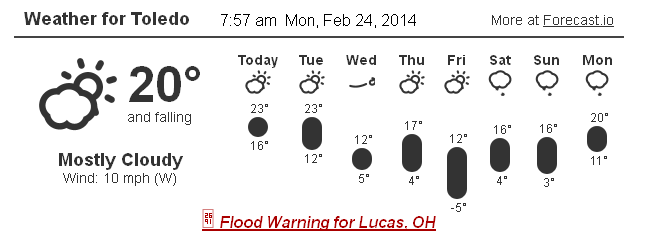
Toledo 7-day forecast
Last Update: Feb 24, 2014 9:52 am
Today: Partly sunny, with a high near 22. West wind around 18 mph, with gusts as high as 31 mph.
Tonight: A slight chance of snow showers after 2am. Mostly cloudy, with a low around 10. Wind chill values as low as zero. West wind 7 to 15 mph. Chance of precipitation is 20%.
Tuesday: A chance of snow showers, mainly between 9am and 10am. Mostly cloudy, with a high near 23. Wind chill values as low as -3. West wind 5 to 15 mph. Chance of precipitation is 30%. Little or no snow accumulation expected.
Tuesday Night: Mostly cloudy, with a low around 3. Wind chill values as low as -14. West wind 14 to 16 mph.
Wednesday: Partly sunny, with a high near 13. Northwest wind 11 to 16 mph.
Wednesday Night: Mostly cloudy, with a low around 4.
Thursday: Partly sunny, with a high near 18.
Thursday Night: Mostly cloudy, with a low around -1.
Friday: Partly sunny, with a high near 16.
Friday Night: Mostly cloudy, with a low around 3.
Saturday: Mostly cloudy, with a high near 16.
Saturday Night: Mostly cloudy, with a low around -3.
Sunday: Partly sunny, with a high near 14.
fxus61 kcle 241158
afdcle
area forecast discussion
national weather service cleveland oh
658 am est mon feb 24 2014
synopsis...
a secondary trough will swing across the eastern great lakes
today. arctic high pressure will move over the area overnight. a
series of short waves will move east across the upper ohio valley
the first half of the week.
&&
near term /until 6 pm this evening/...
overnight lows running several degrees above forecast due to
clouds so tweaked todays high up a couple of degrees and adjusted
the cloud cover.
original discussion...
cold front well south of the area...but a secondary trough will
swing across the eastern lakes this afternoon. this combined with
850 mb temps of -16c to -18c should be enough to produce some snow
showers. with boundary level winds due west...and with the lake
now open between the islands and cleveland best location would be
the eastern lakeshore counties. but the 850 mb winds have a
slightly northwesterly fetch so put in chance pops from the
central lakeshore counties across the secondary snowbelt counties.
clouds have already shrouded the lakeshore counties and will push
further south. this combined with the strong caa leaned toward the
cooler met temps for today.
&&
short term /6 pm this evening through thursday night/...
little change
in the short term forecast. arctic high pressure spreads east from
the plains across the lower lakes. however models continue to show
a series of short wave troughs that will swing across the lake
through the period. most of this activity will be lake enhanced and
confined to mainly the snowbelt areas. a widespread synoptic light
snow is expected tonight into tuesday. the ecmwf has been depicting
this for several days and the nam and the gfs is finally coming
around. with limited moisture kept pop in the chance category in the
west. but with the open lake and a nw flow bumped up pops in the
east to likely for tuesday morning.
&&
long term /friday through sunday/...
no major storms for the extended. plenty of surface ridging for
friday through the upcoming weekend.
a weak onshore flow on friday but with plenty of ridging and dry air
will keep the snow belt dry even though the lake and 850 mb
temperature difference will be near 20c to start. elsewhere it will
be dry.
for friday night through saturday and inverted trof will affect the
forecast area. kept 20 to 30 pops across the region for friday night
and low pops in the east saturday. these may have to be raised as
the trends become clearer.
for saturday night through sunday night the gfs model is a little
faster in bringing in some snow. the flow is northerly with plenty
of moisture and the lake and 850 mb temperature difference will be
near 13c...most of the area will have a threat at a chance of snow.
kept slight chance pops for sunday and continued the chance sunday
night.
&&
aviation /12z monday through friday/...
a northwest flow with plenty of stratocumulus clouds...mainly mvfr spreading
south. at this time will keep the ceilings all day. some question
as the low level flow will become west but the 5000 foot flow will
stay northwest. some ceilings could lift to vfr. some flurries or
light snow showers today as a weak trof was brushing the eastern
lakes. the snow flurries/snow showers will be on the increase late
tonight as another surface trof and trof aloft moves towards the
area from the west.
outlook...non vfr at times tuesday through thursday.
&&
marine...
at this time not forecasting gale force winds for the forecast
period but it could be close as we get shots of cold air through the
work week.
for today mainly weak warm advection will keep the winds in the 15
to 25 knot range because of that. a shot of cold air comes in
tuesday night...the winds should stay below gale force. the next
shot of cold air will be on thursday with 850 mb temperatures in the
23 below celsius range. at this time it looks like the sustained
winds should be just below gale force...but it could be close as the
ecmwf has a little stronger winds then the gfs. this will have to be
watched. a ridge builds over the great lakes for next weekend with
relatively light winds for lake erie.
the lake has opened up some especially north and northwest of
cleveland with all the wind we had in the last few days. the ice may
return with the cold air expected for this week.
&&
cle watches/warnings/advisories...
oh...none.
pa...none.
marine...none.
&&
$$
synopsis...djb
near term...djb
short term...djb
long term...kieltyka
aviation...kieltyka
marine...kieltyka
fzus51 kcle 241443
nshcle
nearshore marine forecast
national weather service cleveland oh
943 am est mon feb 24 2014
for waters within five nautical miles of shore on lake erie
lez142>146-242115-
maumee bay to reno beach oh-reno beach to the islands oh-
the islands to vermilion oh-vermilion to avon point oh-
avon point to willowick oh-
943 am est mon feb 24 2014
rest of today...west winds 15 to 25 knots. cloudy. a chance of snow
showers late this morning...then a slight chance of snow showers
this afternoon.
tonight...west winds 10 to 20 knots diminishing to 5 to 15 knots.
cloudy.
tuesday...west winds 5 to 15 knots increasing to 10 to 20 knots.
cloudy. a chance of snow showers in the morning.
tuesday night...west winds 10 to 20 knots increasing to 15 to
25 knots. mostly cloudy. a chance of snow showers overnight.
waves omitted due to the nearshore waters being mostly ice
covered.
see lake erie open lakes forecast for wednesday through friday.
the water temperature off toledo is 33 degrees...off cleveland 34 degrees
and off erie 33 degrees.
$$
lez147>149-242115-
willowick to geneva-on-the lake oh-geneva-on-the-lake to conneaut oh-
conneaut oh to ripley ny-
943 am est mon feb 24 2014
rest of today...west winds 15 to 25 knots. snow showers likely.
tonight...west winds 10 to 20 knots. snow showers likely in the
evening...then a chance of snow showers overnight.
tuesday...west winds 10 to 20 knots becoming southwest. snow
showers likely in the morning...then a chance of snow showers in the
afternoon.
tuesday night...southwest winds 15 to 25 knots becoming west. snow
showers likely.
waves omitted due to the nearshore waters being mostly ice covered.
see lake erie open lakes forecast for wednesday through friday.
the water temperature off toledo is 33 degrees...off cleveland 34 degrees
and off erie 33 degrees.
From JR's : articles
1622 words - 10022 chars
- 9 min read
created on
- #
source
- versions
Related articles
Severe weather threat for Sun, Nov 17, 2013 - Nov 18, 2013
Nov 17, 2013 Toledo area weather notes - Mar 03, 2014
Posts related to Nov 17, 2013 severe weather - Nov 21, 2013
Toledo area weather for early December 2013 - Dec 05, 2013
Mon, Dec 9, 2013 winter storm forecast for Sat, Dec 14 - Dec 14, 2013
more >>