Toledo Weather - Wed, Feb 26, 2014
flood statement
national weather service cleveland oh
348 am est wed feb 26 2014
...the flood warning is cancelled for the following rivers in ohio...
scioto river near prospect
...the flood warning continues for the following rivers in ohio...
vermilion river near vermilion
maumee river at waterville
precautionary/preparedness actions...
never drive your car through flooded roadways. the water may be
deeper than it appears. turn around...don`t drown!
stay tuned to noaa weather radio and other local media for further
details and updates.
&&
ohc095-173-261647-
/o.con.kcle.fl.w.0016.000000t0000z-140227t1200z/
/wtvo1.1.er.140222t0603z.140223t0730z.140227t0600z.no/
348 am est wed feb 26 2014
the flood warning continues for
the maumee river at waterville.
* at 3:00 am wednesday the stage was 9.8 feet.
* flood stage is 9.0 feet.
* minor flooding is occurring and minor flooding is forecast.
* forecast...the river will fall below flood stage early thursday
morning. however...it is possible the extensive ice coverage on
the river may slow the recession into thursday afternoon.
* at 9.0 feet...flooding occurs in lowland areas near the river.
Toledo 7-day forecast
Last Update: Feb 26, 2014 6:19 am
Today: A chance of snow showers, mainly before 11am. Mostly cloudy, with a high near 13. Wind chill values as low as -8. West wind 10 to 13 mph. Chance of precipitation is 30%. Little or no snow accumulation expected.
Tonight: Mostly cloudy, with a low around 4. Wind chill values as low as -14. Southwest wind 11 to 15 mph.
Thursday: A chance of snow showers before 4pm. Partly sunny, with a high near 13. Wind chill values as low as -15. Breezy, with a west wind 17 to 21 mph. Chance of precipitation is 30%. New snow accumulation of less than a half inch possible.
Thursday Night: Partly cloudy, with a low around -10. West wind 6 to 11 mph becoming light southwest after midnight.
Friday: Mostly sunny, with a high near 16. Calm wind becoming southeast 5 to 8 mph in the afternoon.
Friday Night: Snow likely, mainly after 2am. Cloudy, with a low around 11. Chance of precipitation is 60%.
Saturday: Snow likely, mainly before 8am. Cloudy, with a high near 25. Chance of precipitation is 60%.
Saturday Night: Snow likely. Cloudy, with a low around 8. Chance of precipitation is 60%.
Sunday: Snow likely. Cloudy, with a high near 23. Chance of precipitation is 60%.
Sunday Night: Snow likely. Cloudy, with a low around 5. Chance of precipitation is 60%.
Monday: Snow showers likely. Mostly cloudy, with a high near 23. Chance of precipitation is 60%.
Monday Night: A chance of snow showers. Mostly cloudy, with a low around 6. Chance of precipitation is 30%.
Tuesday: Partly sunny, with a high near 21.
fxus61 kcle 261130
afdcle
area forecast discussion
national weather service cleveland oh
630 am est wed feb 26 2014
synopsis...
another arctic cold front will move across the area overnight. the
arctic air will remain entrenched over the area through the end
of the work week.
&&
near term /until 6 pm this evening/...
trough well south of the area now with lake effect snow showers
already developing. snow not too heavy but should continue through
most of the morning. pushed likely pops west to include central
highlands.
original discussion...
trough south of the lakeshore and should push south of the area
toward daybreak. band of moderate snow just south of the lakeshore
producing between one inch and an inch and a half per hour...and
moving southeast around 15-20 knots. should be pushing south of the
forecast area toward the morning rush hour. do expect lake effect
snow showers to develop later this morning across ne oh and nw pa
with a nw flow over the open portion of lake erie and 850mb temps
hovering around -24c. could see an additional couple of inches
across the primary and secondary snowbelt this morning. by this
afternoon snow should be confined to the snowbelt as winds back to
the west. snow will end by this evening as high pressure ridge
finally moves over the area and the winds back to the southwest.
&&
short term /6 pm this evening through saturday night/...
it will be cold this morning with west to northwest winds
bringing wind chills down close to advisory levels. but thursday
and friday will be even colder as we get another shot of arctic
air overnight. a wind chill advisory will likely be needed
tomorrow morning and friday morning with wind chills in the minus
10 to minus 15 degree range.
high pressure should build over the area thursday night to shut down
the lake effect snow. the question is how much of the cloud cover
will dissipate by friday morning. if it clears out all locations
will see below zero temperatures. it already appears that some of
the western areas will see minus ten or colder.
models in reasonably good agreement moving the next system across
the area friday night into saturday morning.
&&
long term /sunday through tuesday/...
the long term begins on sunday with the gfs and ecmwf showing deep
moisture across the region. high pressure will be over the northern
plains and upper mid west while a stationary front will extend from
texas through the lower ohio valley. would expect disturbances
moving up the front to bring snow to the area sunday and sunday
night with rain and freezing rain to our south. the surface high
begins to build in late monday and monday night which should dry the
area out for mid week.
&&
aviation /12z wednesday through sunday/...
arctic front now southeast of the area with high pressure and drier
but colder air filling in behind. ample moisture in the lower
levels however will likely be enough to create an mvfr deck
through the morning due to heating. mixing should thin the deck in
the afternoon. overnight another arctic front will drop across the
area and bring cigs back down to mvfr with scattered snow showers.
outlook...non vfr at times thursday and friday...mainly across
extreme ne oh/nw pa. non-vfr developing most areas saturday and
continuing sunday.
&&
marine...
will continue with the gale watch. high pressure will build into the
area today. thursday a fairly strong clipper system will move
through the central lakes. an arctic cold front will sweep across
the lake in the early morning hours thursday. expect winds to
increase from the west/southwest and increase to near gale force.
high pressure builds over the lake thursday night and friday.
expect another low to move through the lakes saturday. high
pressure will be north of the lake sunday with a stationary from
across the lower ohio valley turning winds northeast.
&&
cle watches/warnings/advisories...
oh...none.
pa...none.
marine...gale watch from late tonight through thursday evening for
lez061-146>149-166>169.
&&
$$
synopsis...djb
near term...djb
short term...djb
long term...tk
aviation...tk
marine...tk
fzus51 kcle 260830
nshcle
nearshore marine forecast
national weather service cleveland oh
330 am est wed feb 26 2014
for waters within five nautical miles of shore on lake erie
lez142>145-261515-
maumee bay to reno beach oh-reno beach to the islands oh-
the islands to vermilion oh-vermilion to avon point oh-
330 am est wed feb 26 2014
today...west winds 10 to 20 knots. mostly cloudy. a chance of snow
showers this morning...then a slight chance of snow showers this
afternoon.
tonight...southwest winds 10 to 20 knots increasing to 30 knots.
mostly cloudy.
thursday...west winds to 30 knots. partly sunny. a chance of snow
showers in the morning.
thursday night...west winds 15 to 25 knots diminishing to 5 to
15 knots. mostly cloudy in the evening...then becoming partly
cloudy. a chance of flurries in the evening.
waves omitted due to the nearshore waters being mostly ice covered.
see lake erie open lakes forecast for friday through sunday.
the water temperature off toledo is 33 degrees...off cleveland 34 degrees
and off erie 34 degrees.
$$
lez146>149-261515-
avon point to willowick oh-willowick to geneva-on-the lake oh-geneva-
on-the-lake to conneaut oh-conneaut oh to ripley ny-
330 am est wed feb 26 2014
..gale watch in effect from late tonight through thursday evening...
today...west winds 10 to 20 knots. snow showers likely this
morning...then a chance of snow showers this afternoon.
tonight...southwest winds 10 to 20 knots increasing to 30 knots.
mostly cloudy with a chance of snow showers.
thursday...west gales to 35 knots. snow showers likely.
thursday night...west winds to 30 knots diminishing to 5 to
15 knots overnight. mostly cloudy. a chance of snow showers in the
evening...then a chance of flurries overnight.
waves omitted due to the nearshore waters being mostly ice covered.
see lake erie open lakes forecast for friday through sunday.
the water temperature off toledo is 33 degrees...off cleveland 34 degrees
and off erie 34 degrees.
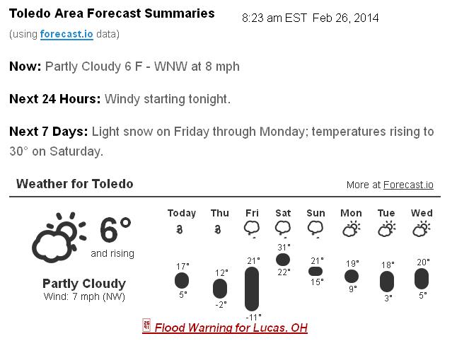
Forecast.io hi-lo Toledo predictions as of 8:00 a.m. today, Feb 26
- today, Wed, Feb 26 : 17 and 5
- Thu, Feb 27 : 12 and -2
- Fri, Feb 28 : 21 and -11
- Sat, Mar 1 : 31 and 22
- Sun, Mar 2 : 21 and 15
- Mon, Mar 3 : 19 and 9
- Tue, Mar 4 : 18 and 3
- Wed, Mar 5 : 20 and 5
This model shows metro Toledo receiving 4 to 8 inches of snow by 7:00 p.m., Mon, Mar 3.
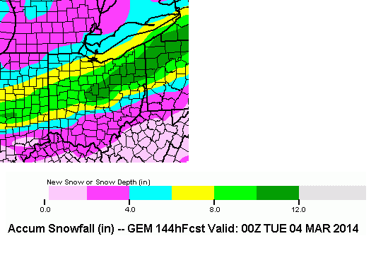
The Cleveland NWS states only the following this morning:
the long term begins on sunday with the gfs and ecmwf [models] showing deep moisture across the region.would expect disturbances moving up the front to bring snow to the area sunday and sunday night.
The Northern Indiana NWS said:
still substantial differences in model fcsts remain on where band of heaviest precip associated with this system will occur.
I think this all means that another 48 hours is needed for the mathematics to line up better.
Some storm systems are more difficult to predict well in advance with the computer models.
If you are forecasting for your family, then predict 2 to 12 inches of new snowfall by Tuesday morning. I'm 50 percent positive that you should be at least 90 percent accurate with that prediction. I'll know more by Sunday evening when I'm done calculating my model with a slide rule.
hazardous weather outlook
national weather service cleveland oh
1045 am est wed feb 26 2014
ohz003-006>014-017>023-027>033-036>038-047-089-paz001>003-271200-
lucas-wood-ottawa-sandusky-erie oh-lorain-cuyahoga-lake-geauga-
ashtabula inland-hancock-seneca-huron-medina-summit-portage-trumbull-
wyandot-crawford-richland-ashland-wayne-stark-mahoning-marion-morrow-
holmes-knox-ashtabula lakeshore-northern erie-southern erie-
crawford pa-
1045 am est wed feb 26 2014
this hazardous weather outlook is for north central
ohio...northeast ohio...northwest ohio and northwest pennsylvania.
.day one...today and tonight.
wind chills will drop into the -10 to -15 degree range tonight. a
wind chill advisory may be needed.
.days two through seven...thursday through tuesday.
wind chill values may fall to as low as -15 for a period of time thursday
night before winds become light.
accumulating snow is expected over the weekend as a low pressure
system tracks northeast up the tennessee valley. snow may develop as
early as saturday night and could continue into monday.
accumulations will depend on the exact track and strength of the
low pressure system but could be significant. please stay tuned to
later forecasts for updates on this developing storm.
.spotter information statement...
spotter activation is not expected at this time.
From JR's : articles
1851 words - 11450 chars
- 10 min read
created on
updated on
- #
source
- versions
Related articles
Severe weather threat for Sun, Nov 17, 2013 - Nov 18, 2013
Nov 17, 2013 Toledo area weather notes - Mar 03, 2014
Posts related to Nov 17, 2013 severe weather - Nov 21, 2013
Toledo area weather for early December 2013 - Dec 05, 2013
Mon, Dec 9, 2013 winter storm forecast for Sat, Dec 14 - Dec 14, 2013
more >>