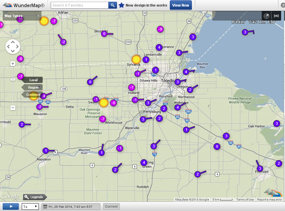
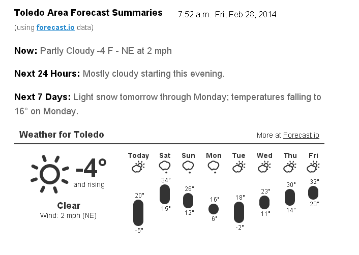
Toledo Weather - Fri, Feb 28, 2014
Last day of winter as defined by the meteorological calendar from Dec 1 to Feb 28/29.
Toledo Express Airport:
Feb 28, 2014 6:52 am
Weather : Fair
Temperature : -6 F
Humidity : 83%
Wind Speed : Calm
Barometer : 30.29 in
Dewpoint: -10 F
Visibility : 10.00 statute miles
(near Lambertville)
Feb 28, 2014 7:15 am
Weather : Fair
Temperature : 0 F
Humidity : 78%
Wind Speed : E 3 mph
Barometer : 30.30 in
Dewpoint: -6 F
Visibility : 10.00 statute miles
Wind Chill : -7 F
Toledo 7-day forecast
Last Update: Feb 28, 2014 6:08 am
Today: Mostly sunny, with a high near 18. Wind chill values as low as -14. Light east wind becoming southeast 5 to 9 mph in the morning.
Tonight: A slight chance of snow after 2am. Mostly cloudy, with a low around 15. Southeast wind around 6 mph becoming light and variable. Chance of precipitation is 20%.
Saturday: A chance of snow. Cloudy, with a high near 32. Southwest wind 5 to 10 mph becoming northwest in the afternoon. Chance of precipitation is 40%. New snow accumulation of less than a half inch possible.
Saturday Night: Snow, mainly after 9pm. Low around 12. Wind chill values as low as zero. North wind around 10 mph. Chance of precipitation is 90%.
Sunday: Snow likely. Cloudy, with a high near 18. Northeast wind around 9 mph. Chance of precipitation is 70%.
Sunday Night: A chance of snow. Cloudy, with a low around 7. Chance of precipitation is 50%.
Monday: A chance of snow before 1pm. Partly sunny, with a high near 16. Chance of precipitation is 40%.
Monday Night: Partly cloudy, with a low around -1.
Tuesday: Mostly sunny, with a high near 22.
Tuesday Night: Mostly cloudy, with a low around 5.
Wednesday: Mostly sunny, with a high near 30.
Wednesday Night: Mostly cloudy, with a low around 14.
Thursday: Partly sunny, with a high near 30.
fxus61 kcle 281121
afdcle
area forecast discussion
national weather service cleveland oh
621 am est fri feb 28 2014
synopsis...
high pressure over the area will move east today the a cold front
will move southeast across the region saturday then stall. low
pressure will come out of texas sunday and move northeast along the
front to be off the virginia coast monday evening. high pressure
will move southeast from minnesota over lake erie tuesday and off
the new england coast by late wednesday.
&&
near term /through tonight/...
flurries continue over the west part of the cle metro area but
should soon end.
rh fields indicate that high clouds should be on the increase today
while the surface high over the area shifts off to the east. warm
advection in the lower levels starts to occur...so temps should
start to moderate a little today with highs in the sw maybe into the
low and possibly mid 20s while the ne struggles into the mid to
upper teens.
&&
short term /saturday through monday night/...
the models still show moisture advecting into the area. as
usual...the gfs is faster. even though the model shows precip (snow)
advancing ne well into the cwa...the gfs mos guidance only has a 10
to 15% chance on average for the west. ongoing forecast had chance
pops for much of the cwa by 12z. will back this down some and keep
the chance/slight chance for mainly just the west.
low temps will be warmer due to the south winds and cloud cover but
still below normal.
the cold front remains on track to move se across the cwa sat
bringing a light band of snow of generally an inch or less. some
rain may mix in over the south as temps rise above 35. behind the
front there may be a lull in the snow later sat into early sat eve
due to subsidence behind the front.
the precip break will be short-lived as an overrunning set up
develops and snow spreads east back across the area sat night. this
looks to be a prolonged event of snow that should last well into
monday. the models differ on when...how and how strong the
wave/waves of low pressure move ne along the front. the vertical
temp profile may be marginal in the south for all snow so some fzra
may mix in at times...sat night thru midday sun but for now will
side more with the colder gfs and keep it all snow.
not sure how heavy the snow will be at any given time...and whether
warning criteria of 6 inches in 12 hours or 8 inches in 24 hours
will be met. would like to hold off on issuing winter storm watch
since the significant snow likely to not begin until the later part
of the 4th period. the heavier snow may not occur until sun night
into early mon when the upper trough finally moves east into ky and
the heavier snow could be south of the cwa...or just in the southern
part. maybe the 12z model runs will begin to agree more on whether
and when heavier snow may occur.
sat will be the warmest day of the stretch...with highs inching a
little above freezing for at least the se half of the area. temps
then fall back well below normal the rest of the time thru mon
night. lows mon night may again be near zero.
&&
long term /tuesday through thursday/...
long term begins on tuesday with both the gfs and ecmwf showing high
pressure and dry air moving in from the wnw. the high builds across
the great lakes wednesday and then east into new england on
thursday. obviously a fairly dry scenario with the exception of a
few snow showers off any open water from time to time. after the
high moves east however...the airmass begins to moderate with 850mb
temps approaching 0c by wednesday evening as the dreaded polar
vortex looses its influence on the area. thursday 850mb temps move
up another couple degrees in a fairly zonal flow aloft. models do
show a short wave moving through the great lakes during the day but
for now will not have anything more than a slight chance of rain or
snow. the outlook for friday indicates further moderating with a
trof developing across the central plains driving 850mb temps to +4
to +6c during the day.
&&
aviation /12z friday through tuesday/...
high pressure and dry stable airmass across area will continue
through midnight tonight. mid and high level moisture will begin
to increase after midnight from the west. will continue vfr
conditions through the night however near the end of the period
saturday morning around daybreak cigs may be getting close to mvfr.
for now continued vfr although did take cigs to 4500 ft west
after 09z.
outlook...non-vfr developing most areas saturday in -shsn.
widespread accumulating snow sunday into monday.
&&
marine...
no headlines expected through the forecast period. winds will remain
generally light today turning southwest saturday and increasing to
10 to 15 knots ahead of a cold front that will cross the lake during
the day. expect west flow turning north through the evening saturday
night behind the front at similar speeds. sunday and sunday night
winds will veer further to northeast increasing to 15 to 20 knots as
low pressure moves through the ohio valley followed by building high
pressure from the northwest. monday into tuesday the high will build
across the lakes.
&&
cle watches/warnings/advisories...
oh...none.
pa...none.
marine...none.
&&
$$
synopsis...adams
near term...adams
short term...adams
long term...tk
aviation...tk
marine...tk
fzus51 kcle 280802
nshcle
nearshore marine forecast
national weather service cleveland oh
302 am est fri feb 28 2014
for waters within five nautical miles of shore on lake erie
lez142>149-281545-
maumee bay to reno beach oh-reno beach to the islands oh-
the islands to vermilion oh-vermilion to avon point oh-
avon point to willowick oh-willowick to geneva-on-the lake oh-geneva-
on-the-lake to conneaut oh-conneaut oh to ripley ny-
302 am est fri feb 28 2014
today...southeast winds 10 knots or less. mostly sunny.
tonight...southeast winds 10 knots or less becoming south. mostly
cloudy.
saturday...southwest winds 5 to 15 knots becoming west. cloudy with
a chance of snow.
saturday night...northwest winds 10 to 15 knots becoming north.
snow.
waves omitted due to the nearshore waters being mostly ice covered.
see lake erie open lakes forecast for sunday through tuesday.
the water temperature off toledo is 33 degrees...off cleveland 34 degrees
and off erie 34 degrees.
$$
fxus61 kcle 281715
afdcle
area forecast discussion
national weather service cleveland oh
1215 pm est fri feb 28 2014
synopsis...
high pressure over the area will move east today the a cold front
will move southeast across the region saturday then stall. low
pressure will come out of texas sunday and move northeast along the
front to be off the virginia coast monday evening. high pressure
will move southeast from minnesota over lake erie tuesday and off
the new england coast by late wednesday.
&&
near term /until 6 pm this evening/...
only minor changes have been made to the forecast today. nudged
highs a degree or two across the east where more sunshine and
downsloping flow are expected.
previous discussion...
flurries continue over the west part of the cle metro area but
should soon end.
rh fields indicate that high clouds should be on the increase today
while the surface high over the area shifts off to the east. warm
advection in the lower levels starts to occur...so temps should
start to moderate a little today with highs in the sw maybe into the
low and possibly mid 20s while the ne struggles into the mid to
upper teens.
&&
short term /6 pm this evening through monday night/...
the models still show moisture advecting into the area. as
usual...the gfs is faster. even though the model shows precip (snow)
advancing ne well into the cwa...the gfs mos guidance only has a 10
to 15% chance on average for the west. ongoing forecast had chance
pops for much of the cwa by 12z. will back this down some and keep
the chance/slight chance for mainly just the west.
low temps will be warmer due to the south winds and cloud cover but
still below normal.
the cold front remains on track to move se across the cwa sat
bringing a light band of snow of generally an inch or less. some
rain may mix in over the south as temps rise above 35. behind the
front there may be a lull in the snow later sat into early sat eve
due to subsidence behind the front.
the precip break will be short-lived as an overrunning set up
develops and snow spreads east back across the area sat night. this
looks to be a prolonged event of snow that should last well into
monday. the models differ on when...how and how strong the
wave/waves of low pressure move ne along the front. the vertical
temp profile may be marginal in the south for all snow so some fzra
may mix in at times...sat night thru midday sun but for now will
side more with the colder gfs and keep it all snow.
not sure how heavy the snow will be at any given time...and whether
warning criteria of 6 inches in 12 hours or 8 inches in 24 hours
will be met. would like to hold off on issuing winter storm watch
since the significant snow likely to not begin until the later part
of the 4th period. the heavier snow may not occur until sun night
into early mon when the upper trough finally moves east into ky and
the heavier snow could be south of the cwa...or just in the southern
part. maybe the 12z model runs will begin to agree more on whether
and when heavier snow may occur.
sat will be the warmest day of the stretch...with highs inching a
little above freezing for at least the se half of the area. temps
then fall back well below normal the rest of the time thru mon
night. lows mon night may again be near zero.
&&
long term /tuesday through friday/...
long term begins on tuesday with both the gfs and ecmwf showing high
pressure and dry air moving in from the wnw. the high builds across
the great lakes wednesday and then east into new england on
thursday. obviously a fairly dry scenario with the exception of a
few snow showers off any open water from time to time. after the
high moves east however...the airmass begins to moderate with 850mb
temps approaching 0c by wednesday evening as the dreaded polar
vortex looses its influence on the area. thursday 850mb temps move
up another couple degrees in a fairly zonal flow aloft. models do
show a short wave moving through the great lakes during the day but
for now will not have anything more than a slight chance of rain or
snow. the outlook for friday indicates further moderating with a
trof developing across the central plains driving 850mb temps to +4
to +6c during the day.
&&
aviation /12z friday through tuesday/...
vfr conditions will continue through the forecast period. clouds
will gradually thicken and lower tonight ahead of approaching cold
front. southeast winds 6-10 knots will continue into this evening.
outlook...non-vfr developing most areas saturday in -sn.
widespread accumulating snow saturday night into monday.
&&
marine...
no headlines expected through the forecast period. winds will remain
generally light today turning southwest saturday and increasing to
10 to 15 knots ahead of a cold front that will cross the lake during
the day. expect west flow turning north through the evening saturday
night behind the front at similar speeds. sunday and sunday night
winds will veer further to northeast increasing to 15 to 20 knots as
low pressure moves through the ohio valley followed by building high
pressure from the northwest. monday into tuesday the high will build
across the lakes.
&&
cle watches/warnings/advisories...
oh...none.
pa...none.
marine...none.
&&
$$
synopsis...adams
near term...adams/mullen
short term...adams
long term...tk
aviation...djb
marine...tk
Toledo 7-day forecast
Last Update: Feb 28, 2014 12:30 pm
This Afternoon: Partly sunny, with a high near 19. Southeast wind around 9 mph.
Tonight: Mostly cloudy, with a low around 15. Southeast wind 7 to 10 mph becoming southwest after midnight.
Saturday: Snow likely, mainly after 5pm. Cloudy, with a high near 32. West wind 8 to 10 mph. Chance of precipitation is 60%. New snow accumulation of less than a half inch possible.
Saturday Night: Snow. Low around 12. Wind chill values as low as zero. North wind around 11 mph. Chance of precipitation is 90%.
Sunday: Snow likely. Cloudy, with a high near 18. Northeast wind around 9 mph. Chance of precipitation is 70%.
Sunday Night: A chance of snow. Cloudy, with a low around 7. Chance of precipitation is 50%.
Monday: A chance of snow before 1pm. Partly sunny, with a high near 16. Chance of precipitation is 40%.
Monday Night: Partly cloudy, with a low around -1.
Tuesday: Mostly sunny, with a high near 22.
Tuesday Night: Mostly cloudy, with a low around 5.
Wednesday: Mostly sunny, with a high near 30.
Wednesday Night: Mostly cloudy, with a low around 14.
Thursday: Partly sunny, with a high near 30.
From JR's : articles
2542 words - 14767 chars
- 14 min read
created on
updated on
- #
source
- versions
Related articles
Severe weather threat for Sun, Nov 17, 2013 - Nov 18, 2013
Nov 17, 2013 Toledo area weather notes - Mar 03, 2014
Posts related to Nov 17, 2013 severe weather - Nov 21, 2013
Toledo area weather for early December 2013 - Dec 05, 2013
Mon, Dec 9, 2013 winter storm forecast for Sat, Dec 14 - Dec 14, 2013
more >>