Toledo Weather - Mar 2, 2014
urgent - winter weather message
national weather service cleveland oh
322 am est sun mar 2 2014
...winter storm continues to move across the region today...
.snow will continue to move into the area today as a wave of low
pressure moves through the lower ohio valley. snow will diminish
from the north late this afternoon and this evening as drier air
and high pressure push in from the north.
ohz003-006>013-017>020-021630-
/o.con.kcle.ww.y.0011.000000t0000z-140302t1800z/
lucas-wood-ottawa-sandusky-erie oh-lorain-cuyahoga-lake-geauga-
hancock-seneca-huron-medina-
including the cities of...toledo...bowling green...port clinton...
fremont...sandusky...lorain...cleveland...mentor...chardon...
findlay...tiffin...norwalk...medina
322 am est sun mar 2 2014
...winter weather advisory remains in effect until 1 pm est this
afternoon...
- accumulations...storm total snowfall of 2 to 4 inches.
- timing...snow will continue this morning and then taper off
during the afternoon.
- visibilities...visibilities will occasionally drop to under a
mile in snow.
- winds...north to northeast winds of 10 to 15 mph.
- temperatures...15 to 20.
- impacts...roads will become snow covered and travel will be slow.
precautionary/preparedness actions...
a winter weather advisory is normally issued for a variety of
winter weather conditions such as light snow... blowing snow...
sleet... freezing rain and wind chills. while the weather will be
significant... the word advisory implies that severe winter
weather is not anticipated. stay tuned to noaa weather radio for
further details or updates.
hazardous weather outlook
national weather service cleveland oh
623 am est sun mar 2 2014
ohz003-006>013-017>020-031130-
lucas-wood-ottawa-sandusky-erie oh-lorain-cuyahoga-lake-geauga-
hancock-seneca-huron-medina-
623 am est sun mar 2 2014
...winter weather advisory in effect until 1 pm est this afternoon...
this hazardous weather outlook is for north central
ohio...northeast ohio and northwest ohio.
.day one...today and tonight.
please listen to noaa weather radio or go to weather.gov on the
internet for more information about the following hazards.
winter weather advisory.
.days two through seven...monday through saturday.
no hazardous weather is expected at this time.
.spotter information statement...
spotter activation is not expected at this time.
Toledo Express Airport
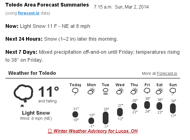
Mar 2, 2014 6:52 am
Weather : Light Snow Fog/Mist
Temperature : 11 F
Humidity : 84%
Wind Speed : ENE 12 mph
Barometer : 30.28 in
Dewpoint: 7 F
Visibility : 3.00 statute miles
Wind Chill : -4 F
Toledo 7-day forecast
Last Update: Mar 2, 2014 2:59 am
Today: Snow, mainly before 4pm. High near 18. Wind chill values as low as -1. Northeast wind 7 to 11 mph. Chance of precipitation is 80%. Total daytime snow accumulation of 1 to 2 inches possible.
Tonight: A chance of snow showers, mainly before 9pm. Mostly cloudy, with a low around 4. Wind chill values as low as -10. East wind 6 to 10 mph becoming north after midnight. Chance of precipitation is 30%. New snow accumulation of less than a half inch possible.
Monday: Mostly sunny, with a high near 15. Wind chill values as low as -11. North wind 7 to 10 mph.
Monday Night: Mostly cloudy, with a low around -2. North wind around 5 mph becoming calm in the evening.
Tuesday: A chance of snow, mainly after 2pm. Cloudy, with a high near 22. Southwest wind 3 to 5 mph. Chance of precipitation is 30%.
Tuesday Night: A chance of snow. Cloudy, with a low around 11. Chance of precipitation is 30%.
Wednesday: A chance of snow before 8am. Cloudy, with a high near 27. Chance of precipitation is 30%.
Wednesday Night: Mostly cloudy, with a low around 12.
Thursday: Partly sunny, with a high near 30.
Thursday Night: Mostly cloudy, with a low around 19.
Friday: A chance of rain and snow. Partly sunny, with a high near 35. Chance of precipitation is 30%.
Friday Night: A chance of rain and snow. Mostly cloudy, with a low around 25. Chance of precipitation is 30%.
Saturday: A chance of snow. Mostly cloudy, with a high near 34. Chance of precipitation is 30%.
fxus61 kcle 021127
afdcle
area forecast discussion
national weather service cleveland oh
627 am est sun mar 2 2014
synopsis...
a cold front will stall across the tennessee and lower ohio valley
today as waves of low pressure move along the boundary. high
pressure and dry stable air will build across the area from the
northwest tonight and monday. high pressure will continue in the
area through mid week.
&&
near term /through tonight/...
update...no changes for the update.
original...light to occasionally moderate snow is falling across
the area. snow continues to look favorable today although moisture
will be decreasing from the north during the afternoon. followed
the nam today which shows strong low level frontogenesis across
the area behind the cold front...now across the lower ohio valley.
lift will also be helped by increasingly favorable jet dynamics
with ohio being in the rt entrance region of the jet. will
continue with categorical pops south while to the north will
decrease pops slowly through the afternoon. accums look to be will
be best across the southern tier of counties with 2-4 or 3-5 a
reasonable accum for the day. temps nearly steady or slowly
falling.
&&
short term /monday through wednesday night/...
will taper pops to chance/slight chance category by midnight with
further drying by 12z monday as high pressure builds in.
next chance of snow comes tuesday...mainly afternoon as the
airmass moistens with a short wave moving through the great lakes.
wednesday will keep the slight chance already in place. the gfs
shows a weak wave moving through the region with divergent flow
aloft. best forcing however will be across the southeastern states
ahead of a rather sharp upper trof as well as north of the area
across ontario and quebec as upper low pressure moves through.
temps below normal through the period.
&&
long term /thursday through saturday/...
the expected warm up late next week will only be subtle at best and
brief. fri may be the only day where temps even rise around the
normal point...just ahead of another cold front that moves thru the
area.
still not sure the weak upper trough/inverted surface trough won't
be able to produce some light rain or snow on thu so will put a
slight chance back into the forecast. will leave thu night dry due
to better ridging.
the cold front crossing the area later fri or fri night should
provide the focus for a good threat for rain that will probably
change to snow fri night into sat...or a rain/snow mix.
&&
aviation /12z sunday through thursday/...
widespread snow and ifr conditions will sag south to be affecting
just the southern taf sites by 22z then should continue to push sse
out of fdy...mfd...cak and yng thru 06z or shortly thereafter. a few
light lake effect shsn may occur tonight around cle and maybe other
parts of the snowbelt as north winds bring moisture off of lake
huron into the area.
mainly north winds will prevail thru tonight but should stay under
15 knots.
outlook...non vfr tuesday night into wednesday.
&&
marine...
ne to n winds may blow 15 to 25 knots at times into tonight then
gradually diminish into mon night as high pressure moves over the
lake. a back door cold front will drop across the lake tue then ne
winds will increase back to 15 to 20 knots tue night into wed then
diminish a little and turn east on thu then light and variable for
fri. another cold front looks to be working se across the lake late
fri and should start to shift the variable winds to nw.
&&
cle watches/warnings/advisories...
oh...winter weather advisory until 1 pm est this afternoon for
ohz003-006>013-017>020.
winter weather advisory until 10 pm est this evening for
ohz021>023-027>033-036>038-047.
pa...none.
marine...none.
&&
$$
synopsis...tk
near term...tk
short term...tk
long term...adams
aviation...adams
marine...adams
fzus51 kcle 020805
nshcle
nearshore marine forecast
national weather service cleveland oh
305 am est sun mar 2 2014
for waters within five nautical miles of shore on lake erie
lez142>149-021515-
maumee bay to reno beach oh-reno beach to the islands oh-
the islands to vermilion oh-vermilion to avon point oh-
avon point to willowick oh-willowick to geneva-on-the lake oh-geneva-
on-the-lake to conneaut oh-conneaut oh to ripley ny-
305 am est sun mar 2 2014
today...northeast winds 10 to 15 knots becoming north. snow
through noon then a chance for snow during the afternoon.
tonight...north winds 10 to 15 knots. mostly cloudy. a chance of
snow in the evening.
monday...north winds 10 to 15 knots. mostly sunny.
monday night...north winds less than 10 knots becoming southwest.
partly cloudy in the evening...then becoming mostly cloudy.
waves omitted due to the nearshore waters being mostly ice covered.
see lake erie open lakes forecast for tuesday through thursday.
the water temperature off toledo is 32 degrees...off cleveland 33 degrees
and off erie 33 degrees.
Toledo 7-day forecast
Last Update: Mar 2, 2014 6:51 am
Today: Snow, mainly before 3pm. High near 18. Wind chill values as low as zero. Northeast wind 6 to 11 mph. Chance of precipitation is 80%. Total daytime snow accumulation of around an inch possible.
Tonight: A chance of snow showers, mainly before 8pm. Mostly cloudy, with a low around 4. Wind chill values as low as -11. East wind 6 to 10 mph becoming north after midnight. Chance of precipitation is 30%. New snow accumulation of less than a half inch possible.
Monday: Mostly sunny, with a high near 15. Wind chill values as low as -11. North wind 6 to 10 mph.
Monday Night: Mostly cloudy, with a low around -2. North wind around 5 mph becoming calm in the evening.
Tuesday: A chance of snow, mainly after 1pm. Cloudy, with a high near 22. Southwest wind 3 to 5 mph. Chance of precipitation is 30%.
Tuesday Night: A chance of snow. Cloudy, with a low around 11. Chance of precipitation is 30%.
Wednesday: Cloudy, with a high near 27.
Wednesday Night: Mostly cloudy, with a low around 12.
Thursday: Partly sunny, with a high near 30.
Thursday Night: Mostly cloudy, with a low around 19.
Friday: A chance of rain and snow. Partly sunny, with a high near 35. Chance of precipitation is 30%.
Friday Night: A chance of snow. Mostly cloudy, with a low around 25. Chance of precipitation is 30%.
Saturday: Mostly cloudy, with a high near 34.
hazardous weather outlook
national weather service cleveland oh
1049 am est sun mar 2 2014
ohz003-006>009-014-017>019-027-089-paz001>003-031100-
lucas-wood-ottawa-sandusky-erie oh-ashtabula inland-hancock-seneca-
huron-wyandot-ashtabula lakeshore-northern erie-southern erie-
crawford pa-
1049 am est sun mar 2 2014
this hazardous weather outlook is for north central
ohio...northeast ohio...northwest ohio and northwest pennsylvania.
.day one...today and tonight.
wind chills will range from zero to ten below through tonight.
.days two through seven...monday through saturday.
no hazardous weather is expected at this time.
.spotter information statement...
spotter activation is not expected at this time.
My TT comment, made at 12:18 p.m. today.
My official unofficial tally was 3.25 inches of lightweight, powdery snowfall. It was a fine morning to spend a few hours outside.
Our weather will be a little cool at the start of the week, but it gets balmy by the weekend.
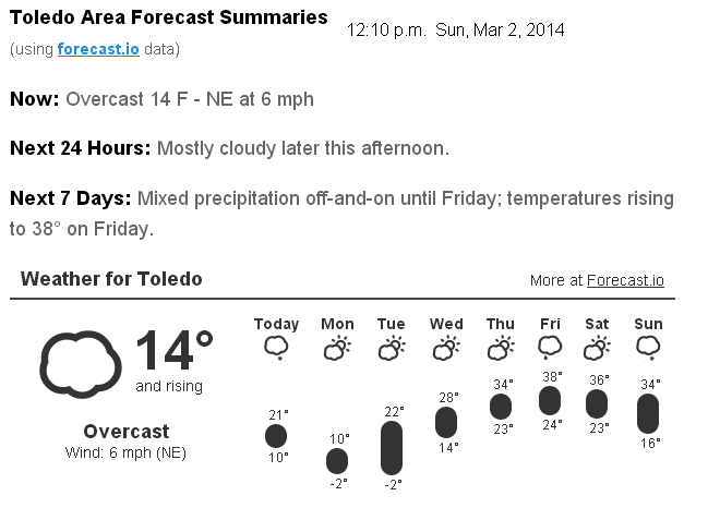
Mid-afternoon temps
From JR's : articles
1832 words - 11520 chars
- 10 min read
created on
updated on
- #
source
- versions
Related articles
Severe weather threat for Sun, Nov 17, 2013 - Nov 18, 2013
Nov 17, 2013 Toledo area weather notes - Mar 03, 2014
Posts related to Nov 17, 2013 severe weather - Nov 21, 2013
Toledo area weather for early December 2013 - Dec 05, 2013
Mon, Dec 9, 2013 winter storm forecast for Sat, Dec 14 - Dec 14, 2013
more >>