Toledo Weather - Mon, Mar 3, 2014
hazardous weather outlook
national weather service cleveland oh
436 am est mon mar 3 2014
ohz003-006>014-017>020-023-027-089-041100-
lucas-wood-ottawa-sandusky-erie oh-lorain-cuyahoga-lake-geauga-
ashtabula inland-hancock-seneca-huron-medina-trumbull-wyandot-
ashtabula lakeshore-
436 am est mon mar 3 2014
this hazardous weather outlook is for north central
ohio...northeast ohio and northwest ohio.
.day one...today and tonight.
wind chill readings will be around -10 degrees first thing this
morning.
.days two through seven...tuesday through sunday.
no hazardous weather is expected at this time.
.spotter information statement...
spotter activation is not expected at this time.
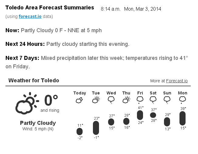
Toledo 7-day forecast
Last Update: Mar 3, 2014 6:33 am
Today: Sunny, with a high near 13. Wind chill values as low as -11. North wind 5 to 8 mph.
Tonight: Partly cloudy, with a low around -3. Calm wind.
Tuesday: A slight chance of snow between 9am and 2pm. Mostly cloudy, with a high near 20. Wind chill values as low as -2. Calm wind becoming southwest around 5 mph. Chance of precipitation is 20%.
Tuesday Night: A slight chance of snow after 9pm. Mostly cloudy, with a low around 8. Calm wind. Chance of precipitation is 20%.
Wednesday: A chance of snow. Mostly cloudy, with a high near 24. Calm wind becoming northeast 5 to 7 mph in the morning. Chance of precipitation is 30%.
Wednesday Night: A chance of snow. Mostly cloudy, with a low around 14. Chance of precipitation is 30%.
Thursday: Partly sunny, with a high near 26.
Thursday Night: Mostly cloudy, with a low around 16.
Friday: Partly sunny, with a high near 37.
Friday Night: A chance of snow. Mostly cloudy, with a low around 23. Chance of precipitation is 30%.
Saturday: A chance of snow. Mostly cloudy, with a high near 32. Chance of precipitation is 30%.
Saturday Night: A chance of snow. Mostly cloudy, with a low around 18. Chance of precipitation is 30%.
Sunday: Partly sunny, with a high near 33.
fxus61 kcle 031154
afdcle
area forecast discussion
national weather service cleveland oh
654 am est mon mar 3 2014
synopsis...
high pressure will build east across the region for today and
tuesday. a weak clipper will slide east across the great lakes on
tuesday and leave a weak front across the lower lakes through mid
week. the next frontal boundary will be crossing the area during
the first part of the weekend.
&&
near term /until 6 pm this evening/...
quiet but cold day today. the combination of temperatures and wind
first thing this morning may make for wind chill readings that are
borderline advisory criteria /-10/ across nrn ohio. this will be
temporary. have continued the wind chill adv for nw pa. expect
their winds to come up some this morning and allow them to reach
as low as -15 degrees.
so winds will come up as the high builds in this morning and low
pressure works its way off the east coast. clouds associated with
the system over the tn valley and the upper trough will exit
today and subsidence/drier air will take over. therefore will
start out cloudy...but expect clearing as the day progresses. not
much improvement in the temperature department with highs only
reaching into the teens. normal highs now are lower 40s. no
changes made with this early morning update.
&&
short term /6 pm this evening through thursday night/...
high pressure directly overhead tonight. with this cold air mass
expect temperatures once again to dip below zero. fortunately this
time around winds will be near calm and will not have any wind
chill issues to deal with. clear to start the night which will
allow for a quick radiational drop in temperatures. some clouds
will be forecast to move into nw oh toward tuesday morning. will
keep temps generally between zero and -5 but as is the case with
these types of nights...the range can be much greater.
for tuesday through thursday baroclinic zone develops across the
lower lakes. weak impulses will try and produce some light
snow...but with dry air in place...will keep just the 20 to 30
percent chances across the far north. there are differences in the
details in the models that will have temperature consequences. the
gfs develops an inverted trough across the upper ohio valley and
therefore buckles that baroclinic zone enough to bring somewhat
warmer air into the area...above freezing by wed/thu. otherwise
the nam and ecmwf allow the frontal zone to sink southward with
time building the high across the great lakes. have sided toward
the colder solution for wed/thu...delaying the warm up. again only
low chance pops at best right now.
&&
long term /friday through sunday/...
should get a decent south southwest flow on friday ahead of the
next cold front. most of the guidance is indicating a nice
moderation in temperature with highs probably near normal in the
lower/mid 40s in most areas.
the warm up may be short lived. the 00z gfs and ecmwf are faster
with the front on saturday. the canadian gem is still slower and has
a wave holding up the front. will nudge the saturday forecast
temperatures a few degrees colder but not go as cold as it could be
considering the uncertainty on the timing on the front. when push
comes to shove there will probably be at least some light
precipitation with the front but will just keep a low chance pop
from friday night through saturday night for now given the
uncertainty on the timing or whether there might be a wave on the
front.
colder again by sunday with pseudo arctic air but as we get toward
mid march the cold should not be as bitter.
&&
aviation /12z monday through friday/...
high pressure will build in today/early tonight. generally vfr
conditions except for a few patches of 018-025bkn this
morning/early afternoon in the north flow off lake erie and lake
huron. clear early tonight then increasing mid and high clouds.
outlook...non vfr wednesday into thursday.
&&
marine...
not expecting any significant winds during the forecast period.
arctic high pressure from the upper midwest will continue to build
across lake erie today and be almost overhead by tonight. a weak
trough of low pressure will cross the northern great lakes on
tuesday. a weak cold front will sag south across the lake early
thursday. winds will come around from the south by friday ahead of
yet another cold front over the weekend.
&&
cle watches/warnings/advisories...
oh...none.
pa...wind chill advisory until 10 am est this morning for
paz001>003.
marine...none.
&&
$$
synopsis...oudeman
near term...oudeman
short term...oudeman
long term...kosarik
aviation...kosarik
marine...kosarik
fzus51 kcle 030902
nshcle
nearshore marine forecast
national weather service cleveland oh
402 am est mon mar 3 2014
for waters within five nautical miles of shore on lake erie
lez142>149-031515-
maumee bay to reno beach oh-reno beach to the islands oh-
the islands to vermilion oh-vermilion to avon point oh-
avon point to willowick oh-willowick to geneva-on-the lake oh-geneva-
on-the-lake to conneaut oh-conneaut oh to ripley ny-
402 am est mon mar 3 2014
today...north winds 10 to 15 knots diminishing to 10 knots or
less. mostly cloudy early then clearing.
tonight...west winds less than 10 knots. mostly clear in the
evening then increasing clouds.
tuesday...south winds less than 10 knots becoming northwest.
mostly cloudy.
tuesday night...northeast winds less than 10 knots. mostly cloudy.
waves omitted due to the nearshore waters being mostly ice covered.
see lake erie open lakes forecast for wednesday through friday.
the water temperature off toledo is 32 degrees...off cleveland 33 degrees
and off erie 33 degrees.
$$
From JR's : articles
1248 words - 7662 chars
- 6 min read
created on
updated on
- #
source
- versions
Related articles
Severe weather threat for Sun, Nov 17, 2013 - Nov 18, 2013
Nov 17, 2013 Toledo area weather notes - Mar 03, 2014
Posts related to Nov 17, 2013 severe weather - Nov 21, 2013
Toledo area weather for early December 2013 - Dec 05, 2013
Mon, Dec 9, 2013 winter storm forecast for Sat, Dec 14 - Dec 14, 2013
more >>