Toledo Weather - Thu, Apr 3, 2014
http://jothut.com/cgi-bin/junco.pl/replies/35219
hazardous weather outlook
national weather service cleveland oh
401 am edt thu apr 3 2014
ohz003-006>014-017>023-027>033-036>038-047-089-paz001>003-040815-
lucas-wood-ottawa-sandusky-erie oh-lorain-cuyahoga-lake-geauga-
ashtabula inland-hancock-seneca-huron-medina-summit-portage-trumbull-
wyandot-crawford-richland-ashland-wayne-stark-mahoning-marion-morrow-
holmes-knox-ashtabula lakeshore-northern erie-southern erie-
crawford pa-
401 am edt thu apr 3 2014
this hazardous weather outlook is for north central
ohio...northeast ohio...northwest ohio and northwest pennsylvania.
.day one...today and tonight.
locally heavy rainfall today through friday may eventually lead to
possible flooding...especially on friday.
.days two through seven...friday through wednesday.
there is a threat for severe thunderstorms friday with large hail
and damaging winds.
.spotter information statement...
spotter activation may become necessary.
Toledo Express Airport:
Apr 3, 2014 8:52 am
Weather : Overcast
Temperature : 36 F
Humidity : 62%
Wind Speed : E 20 mph - Gust 25 mph
Barometer : 30.07 in
Dewpoint: 24 F
Visibility : 10.00 statute miles
Wind Chill : 25 F
Toledo Executive Airport
(formerly Metcalf Airport)
Apr 3, 2014 8:53 am
Weather : Unknown Precip
Temperature : 36 F
Humidity : 64%
Wind Speed : ENE 16 mph - Gust 28 mph
Barometer : 30.09 in
Dewpoint: 25 F
Visibility : 10.00 statute miles
Wind Chill : 26 F
Toledo Suburban Airport
(near Lambertville)
Apr 3, 2014 8:55 am
Weather : Overcast
Temperature : 36 F
Humidity : 65%
Wind Speed : E 15 mph - Gust 21 mph
Barometer : 30.09 in
Dewpoint: 25 F
Visibility : 10.00 statute miles
Wind Chill : 27 F
Toledo 7-day forecast
Last Update: Apr 3, 2014 3:40 am
Today: Showers. High near 41. Breezy, with an east wind 17 to 21 mph. Chance of precipitation is 90%. New precipitation amounts between a quarter and half of an inch possible.
Tonight: Showers, with thunderstorms also possible after 3am. Low around 38. East wind 11 to 18 mph. Chance of precipitation is 80%. New rainfall amounts between a quarter and half of an inch possible.
Friday: Showers and thunderstorms, mainly before 5pm. High near 60. Breezy, with a southeast wind 8 to 13 mph becoming southwest 20 to 25 mph in the afternoon. Winds could gust as high as 36 mph. Chance of precipitation is 100%. New rainfall amounts between a half and three quarters of an inch possible.
Friday Night: A chance of rain showers before 1am, then a chance of rain and snow showers. Mostly cloudy, with a low around 31. Windy, with a southwest wind 22 to 26 mph, with gusts as high as 37 mph. Chance of precipitation is 30%. New precipitation amounts of less than a tenth of an inch possible.
Saturday: A chance of snow showers before 11am, then a slight chance of rain showers between 11am and 3pm. Partly sunny, with a high near 46. Breezy, with a west wind 20 to 22 mph, with gusts as high as 32 mph. Chance of precipitation is 30%. New precipitation amounts of less than a tenth of an inch possible.
Saturday Night: Mostly clear, with a low around 29.
Sunday: Mostly sunny, with a high near 51.
Sunday Night: Partly cloudy, with a low around 36.
Monday: Rain likely. Cloudy, with a high near 49. Chance of precipitation is 60%.
Monday Night: Rain likely. Cloudy, with a low around 35. Chance of precipitation is 60%.
Tuesday: Mostly cloudy, with a high near 52.
Tuesday Night: Mostly cloudy, with a low around 31.
Wednesday: Partly sunny, with a high near 47.
Forecast.io data at 9:25 a.m.
Now: Light Rain 35 F - NE at 14 mph
Next 24 Hours: Breezy starting this afternoon, with rain later this morning.
Next 7 Days: Light rain today through Tuesday, with temperatures rising to 62�F tomorrow.
fxus61 kcle 031132
afdcle
area forecast discussion
national weather service cleveland oh
732 am edt thu apr 3 2014
synopsis...
low pressure over kansas will move northeast through michigan late
friday pulling a cold front across ohio late friday...followed by a
reinforcing cold front early saturday. high pressure will move up
the ohio valley saturday night and off the new jersey coast sunday
then another low will move northeast across ohio late monday with a
trailing cold front crossing the area.
&&
near term /until 6 pm this evening/...
the first impulse will move out of the southern plains while
weakening as it moves along the stalled front near the ohio river.
mid and lower level moisture collecting near the front will finally
have enough of a ne push to spread ne across the cwa with rain
showers becoming more numerous se to ne. the airmass may become
unstable enough aloft for some thunder to occur. unless training of
heavier rains occurs...don't think there will be enough rain for
flooding to develop thru this eve.
since the cwa is on the north side of the front...ne winds and
thickening clouds will keep temps below normal...especially for the
lakeshore areas just downwind of lake erie.
&&
short term /6 pm this evening through sunday night/...
there will probably be a lull in the shra for a while tonight as the
energy with the first impulse moves off to the ene. then the
increasing llvl jet bringing warmer and more moist air into the
area...increased dynamics and the approach of a cold front should
lead to shra and tsra becoming more numerous west to east during the
latter part of the night into fri morning.
the cold front trailing the low moving thru mi will sweep across the
cwa from late fri morning thru fri eve. there appears to be enough
instability and wind shear for some strong to possibly severe storms
to occur with the passage of the cold front. fri into fri night
looks to be a windy period with winds gusting to 40 mph at times.
much of the rain looks to end with the passage of the cold front but
a secondary cold front early sat along with some wrap moisture will
probably produce some rain and snow showers as temps cool well below
normal again. the most likely area for the showers will be in the
snowbelt.
due to the expected lull in precip tonight...not sure if flooding
will develop fri into fri night so would prefer to hold off on a
flood watch.
high pressure builds in sat night so the shrasn should end sat eve.
the influence of the high should produce dry conditions until late
sun night when another low will quickly move out of the lwr ms
valley and head toward the area. using an average of the models
indicates rain possibly spreading ne across at least the ssw half of
the area by daybreak mon.
&&
long term /monday through wednesday/...
low pressure will be moving into the central great lakes on monday
with a period of rain anticipated. continued the likely pops for
monday with them lingering into monday night across the east. high
pressure will ridge into the region tuesday night but do not want to
completely yank the pops into wednesday with the upper level trough
axis still to our west.
the warmest day of the long term will be monday with highs at most
locations into the 50s. cooler tuesday and wednesday with highs
generally in the 40s...maybe some 30s for highs closer to the lake.
&&
aviation /12z thursday through monday/...
stalled frontal boundary near the ohio river valley will continue
to be the track of a couple waves of low pressure today into
tonight. easterly flow will likely make it difficult to move the
rain northeast across northern ohio and may never make it to ne
ohio and nw pa. for now have brought the best chances of rain and
some scattered thunder into nw ohio and maybe the central
highlands. the thunder chances will be best near and south of a
line from ktol to kmfd. believe we will not see mvfr ceilings
until the steadier rain persists for a few hours across nw ohio.
this will slowly spread eastward through the evening but the
easterly downsloping flow will definitely be a factor across ne
ohio and nw pa.
a better shot at some thunder will develop overnight and may move
into nw ohio and over lake erie by sunrise on friday. have hinted
at this possibility in the tafs. as the front moves across the
area friday morning we will need to monitor for some stronger
thunderstorms.
winds will remain ne to east into the afternoon and will begin to
shift to the southeast during the evening. winds could get gusty
off of lake erie...especially west of cleveland. gusts may reach 25
knots around toledo.
outlook...non vfr at times in precipitation thursday night through
saturday.
&&
marine...
low pressure over the southern plains will deepen as it moves into
the western great lakes tonight. this will cause northeast to east
winds on lake erie into early friday morning. winds to 25 knots will
cause significant ice floes to develop as pieces break away from the
ice field across the eastern 2/3rds of the lake. winds will shift
around from southeast to southwest on friday as the low moves into
ontario on friday evening. stronger cold advection in the wake of
the low will cause southwest to west winds to increase to at least
30 knots. the better surge of colder air will arrive friday night
and could boost winds into low end gales. we thought about going
with a gale watch but will let the next shift take a look at it and
issue if needed. high pressure will build across the lake sunday.
the next storm system will move into the central great lakes on
monday.
&&
cle watches/warnings/advisories...
oh...none.
pa...none.
marine...none.
fzus51 kcle 030725
nshcle
nearshore marine forecast
national weather service cleveland oh
325 am edt thu apr 3 2014
for waters within five nautical miles of shore on lake erie
lez142>146-031415-
maumee bay to reno beach oh-reno beach to the islands oh-
the islands to vermilion oh-vermilion to avon point oh-
avon point to willowick oh-
325 am edt thu apr 3 2014
today...east winds 10 to 20 knots increasing to 15 to 25 knots.
rain showers. a chance of thunderstorms this afternoon.
tonight...east winds 15 to 25 knots diminishing to 10 to 20 knots.
rain showers. a chance of thunderstorms in the evening...then
thunderstorms overnight.
friday...south winds 10 to 20 knots becoming southwest and
increasing to 30 knots. rain showers and thunderstorms.
friday night...southwest winds to 30 knots. mostly cloudy. a chance
of rain showers in the evening...then a chance of rain and snow
showers overnight.
winds and waves higher in and near thunderstorms.
waves omitted due to the nearshore waters being mostly ice covered.
see lake erie open lakes forecast for saturday through monday.
the water temperature off toledo is 34 degrees...off cleveland 35 degrees
and off erie 34 degrees.
$$
lez147>149-031415-
willowick to geneva-on-the lake oh-geneva-on-the-lake to conneaut oh-
conneaut oh to ripley ny-
325 am edt thu apr 3 2014
today...northeast winds 10 to 20 knots. a slight chance of snow
showers this morning. cloudy with a chance of rain showers.
tonight...northeast winds 15 to 25 knots becoming east 10 to
20 knots. rain showers with a chance of thunderstorms in the
evening...then rain showers and thunderstorms likely overnight.
friday...southeast winds 10 to 20 knots becoming south 15 to
25 knots. rain showers and thunderstorms.
friday night...southwest winds to 30 knots. a chance of rain
showers and thunderstorms likely in the evening...then a chance of
rain and snow showers overnight.
winds and waves higher in and near thunderstorms.
waves omitted due to the nearshore waters being mostly ice covered.
see lake erie open lakes forecast for saturday through monday.
the water temperature off toledo is 34 degrees...off cleveland 35 degrees
and off erie 34 degrees.
$$
(my ToledoTalk.com comment posted today, Apr 3, 2014, about someone's concern over tomorrow's weather for the Toledo Mud Hens baseball home opener.)
Given the choice between today and tomorrow, Friday's weather is forecast to be much better than today's, so I would say the Mud Hens are lucky to be opening at home tomorrow.
This morning's Toledo temps were about 40 degrees, and now temps have dropped to 34 degrees.
Today: strong northeast winds blowing across frigid Lake Erie will probably keep our temps in the mid 30s all day.
Friday: strong southwest winds will warm Toledo temps to around 60 degrees.
60 degrees vs 35 degrees?
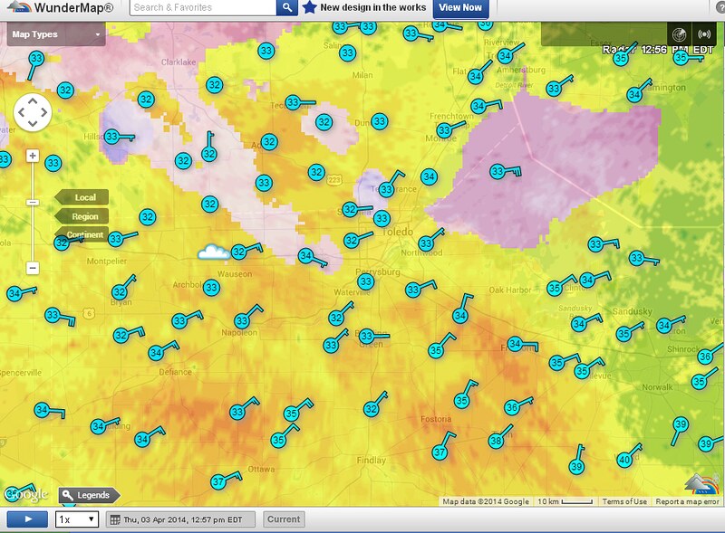
This 10:25 a.m. radar snapshot appears to show that today will be a washout.
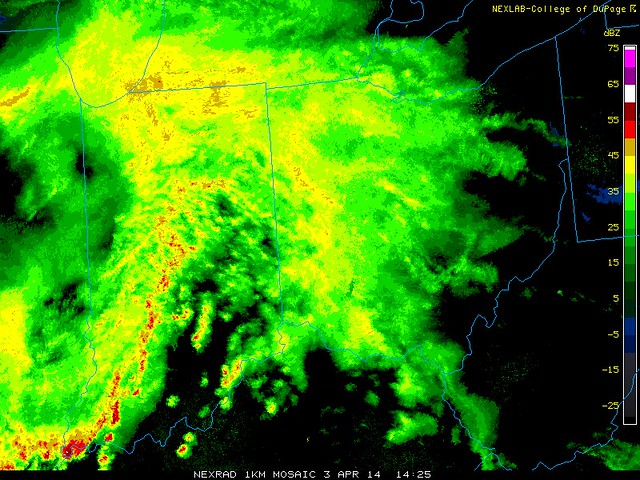
Steady rain, strong winds, and temps in 30s. In my opinion, that's about as bad as it gets, weather-wise for being outdoors. It's tough to stay dry and warm in this mess. If I had to be outside for a prolonged period of time, I'll take cold, dry snow over today's weather.
The Mud Hens game is scheduled to start at 4:00 p.m. on Friday. I don't know if a persistent, steady rain is expected like today, but one issue for Friday will be the chance for thunderstorms.
But if you endured Toledo's winter, then Friday's forecast of 55- to 60-degree temps, brisk winds, and a chance for thunderstorms should be a snap to handle.
And people will still be downtown tomorrow regardless.
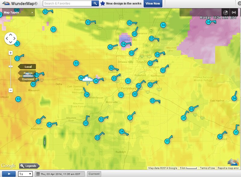
(my second comment in TT thread about the ice that's now forming around Noon time.)
Heads up. Toledo temps at Noon are now around 32 degrees with the rain continuing to fall.
At lunch time, I noticed that a thin layer of ice had formed on tree branches, and small ice sickles were growing on twigs and wires.
The Cleveland National Weather Service has not mentioned anything about freezing rain, but obviously, it is occurring now on some surfaces.
If the temp drops any further, or if it remains at this level for an extended period of time, then we could have some accumulation on trees and wires, which could be a problem with today's brisk winds.
Current weather at Toledo Express Airport:
Apr 3, 2014 11:52 am
Weather : Unknown Precip and Breezy
Temperature : 32 F
Humidity : 88%
Wind Speed : ENE 22 mph - Gust 28 mph
Unknown? It's rain and freezing rain.
Radar shortly after 12:00 p.m. Pink area shows the growing freezing rain/sleet precip area.
fxus61 kcle 031610
afdcle
area forecast discussion
national weather service cleveland oh
1210 pm edt thu apr 3 2014
synopsis...
low pressure over kansas will move northeast across michigan by late
friday. a warm front will move north of the area on friday...then
a cold front will sweep across the area friday afternoon. high
pressure from the pains state will cross the lower great lakes on
sunday. low pressure from texas will move northeast across ohio
late monday with a trailing cold front crossing the area.
&&
near term /until 6 pm this evening/...
the complex over indiana will move east this afternoon. it will
outrun the best support...cloud tops are already warming and the
lightning is diminishing across northern indiana and northwest
ohio...but the mcv will translate east and there will be a
soaking rain especially across the counties south of the turnpike.
mentioned thunder across all but the extreme ne oh/nw pa counties.
temperatures will not rise once the rain develops. nudged the
hourly temperatures down as the rain begins and many areas across
ne oh/nw pa will see temperatures drop with the rain and east to
northeast wind. the models are a little too warm aloft and it will
be cold in toledo until the rain stops...with temperatures barely
above freezing. the ground is not as cold as it was and with the
high sun angle this time of year there would be little danger of
any freezing rain.
&&
short term /6 pm this evening through sunday night/...
there will probably be a lull in the shra for a while tonight as the
energy with the first impulse moves off to the ene. then the
increasing llvl jet bringing warmer and more moist air into the
area...increased dynamics and the approach of a cold front should
lead to shra and tsra becoming more numerous west to east during the
latter part of the night into fri morning.
the cold front trailing the low moving thru mi will sweep across the
cwa from late fri morning thru fri eve. there appears to be enough
instability and wind shear for some strong to possibly severe storms
to occur with the passage of the cold front. fri into fri night
looks to be a windy period with winds gusting to 40 mph at times.
much of the rain looks to end with the passage of the cold front but
a secondary cold front early sat along with some wrap moisture will
probably produce some rain and snow showers as temps cool well below
normal again. the most likely area for the showers will be in the
snowbelt.
due to the expected lull in precip tonight...not sure if flooding
will develop fri into fri night so would prefer to hold off on a
flood watch.
high pressure builds in sat night so the shrasn should end sat eve.
the influence of the high should produce dry conditions until late
sun night when another low will quickly move out of the lwr ms
valley and head toward the area. using an average of the models
indicates rain possibly spreading ne across at least the ssw half of
the area by daybreak mon.
&&
long term /monday through wednesday/...
low pressure will be moving into the central great lakes on monday
with a period of rain anticipated. continued the likely pops for
monday with them lingering into monday night across the east. high
pressure will ridge into the region tuesday night but do not want to
completely yank the pops into wednesday with the upper level trough
axis still to our west.
the warmest day of the long term will be monday with highs at most
locations into the 50s. cooler tuesday and wednesday with highs
generally in the 40s...maybe some 30s for highs closer to the lake.
&&
aviation /12z thursday through monday/...
stalled frontal boundary near the ohio river valley will continue
to be the track of a couple waves of low pressure today into
tonight. easterly flow will likely make it difficult to move the
rain northeast across northern ohio and may never make it to ne
ohio and nw pa. for now have brought the best chances of rain and
some scattered thunder into nw ohio and maybe the central
highlands. the thunder chances will be best near and south of a
line from ktol to kmfd. believe we will not see mvfr ceilings
until the steadier rain persists for a few hours across nw ohio.
this will slowly spread eastward through the evening but the
easterly down sloping flow will definitely be a factor across ne
ohio and nw pa.
a better shot at some thunder will develop overnight and may move
into nw ohio and over lake erie by sunrise on friday. have hinted
at this possibility in the tafs. as the front moves across the
area friday morning we will need to monitor for some stronger
thunderstorms.
winds will remain ne to east into the afternoon and will begin to
shift to the southeast during the evening. winds could get gusty
off of lake erie...especially west of cleveland. gusts may reach 25
knots around toledo.
outlook...non vfr at times in precipitation thursday night through
saturday.
&&
marine...
low pressure over the southern plains will deepen as it moves into
the western great lakes tonight. this will cause northeast to east
winds on lake erie into early friday morning. winds to 25 knots will
cause significant ice floes to develop as pieces break away from the
ice field across the eastern 2/3rds of the lake. winds will shift
around from southeast to southwest on friday as the low moves into
ontario on friday evening. stronger cold advection in the wake of
the low will cause southwest to west winds to increase to at least
30 knots. the better surge of colder air will arrive friday night
and could boost winds into low end gales. we thought about going
with a gale watch but will let the next shift take a look at it and
issue if needed. high pressure will build across the lake sunday.
the next storm system will move into the central great lakes on
monday.
&&
cle watches/warnings/advisories...
oh...none.
pa...none.
marine...none.
flood advisory
national weather service cleveland oh
112 pm edt thu apr 3 2014
ohc095-101-147-175-032115-
/o.new.kcle.fa.y.0013.140403t1712z-140403t2115z/
/00000.0.er.000000t0000z.000000t0000z.000000t0000z.oo/
112 pm edt thu apr 3 2014
the national weather service in cleveland has issued a
- flood advisory for...
marion county in north central ohio...
lucas county in northwest ohio...
seneca county in northwest ohio...
wyandot county in northwest ohio...
- until 515 pm edt
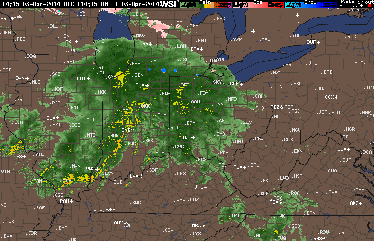
- national weather service doppler radar showed a large area of
moderate to heavy rain crossing northwest and north central ohio.
- rain fall amounts greater than an inch are likely. this will
produce minor flooding. the heaviest rain will taper off late this
afternoon.
precautionary/preparedness actions...
excessive runoff from this storm will cause minor flooding of low
lying and poorly drained roads and underpasses. minor flooding of
farmland near creeks...streams...and drainage ditches is also
likely. never cross a flooded roadway.
&&
lat...lon 4172 8388 4172 8334 4163 8316 4162 8357
4153 8371 4125 8341 4125 8284 4100 8283
4099 8311 4070 8311 4070 8285 4065 8287
4064 8296 4043 8302 4051 8342 4090 8352
4099 8342 4125 8341 4148 8372 4142 8389
short term forecast
national weather service cleveland oh
130 pm edt thu apr 3 2014
ohz003-031830-
lucas oh-
130 pm edt thu apr 3 2014
.now...
freezing rain, rain and thunder will affect the toledo area through
3pm. the rain can be locally heavy with ponding of water on roadways
and low lying areas...ice formation will be on power lines and
tree limbs or perhaps bridges and overpasses.
(My third TT comment)
Statement issued by the Cleveland NWS for the Toledo area:
short term forecast
national weather service cleveland oh
130 pm edt thu apr 3 2014freezing rain, rain and thunder will affect the toledo area through 3pm. the rain can be locally heavy with ponding of water on roadways and low lying areas. ice formation will be on power lines and tree limbs or perhaps bridges and overpasses.
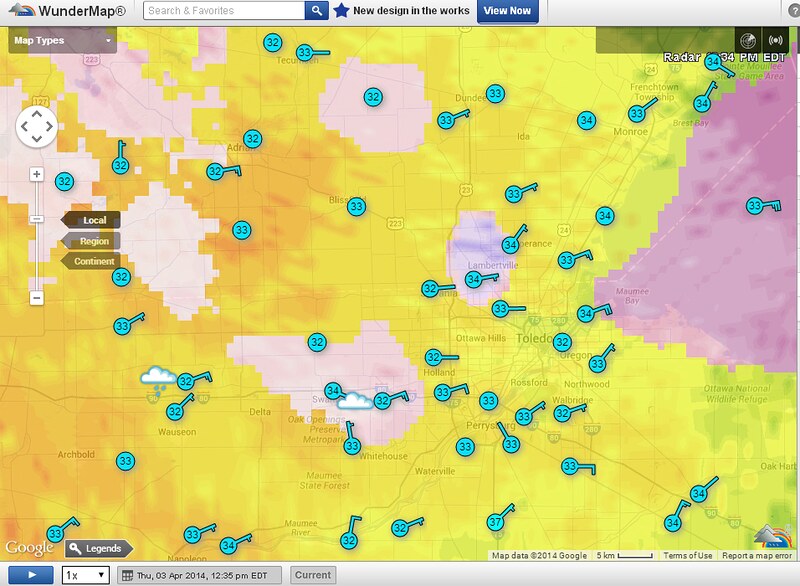
According to radar, it appears that the lake shore areas, located east of the Maumee River and north of Route 2 may receive the most ice accumulation. Northeast Lucas County and northwest Ottawa County.
FirstEnergy Outages Map
http://outages.firstenergycorp.com/oh.html
May not be weather related, but a couple areas in Toledo report small power outages:
Near Sylvania and Douglas:
Customers Affected: 1-20
Cause: Tree Damage
Crew Status: Additional Crews Requested
Estimated Restoration: Apr 3, 3:30 PM
Near Suder and Lehman avenues:
Customers Affected: 21-100
Cause: Pending Investigation
Crew Status: Awaiting Dispatch
Estimated Restoration: Apr 3, 4:00 PM
More small power outages have been reported. The largest one thus far:
Between Fassett and Oakdale in East Toledo
Customers Affected: >1500
Cause: Pending Investigation
Crew Status: Awaiting Dispatch
Estimated Restoration: Apr 3, 5:00 PM
flood advisory
national weather service cleveland oh
302 pm edt thu apr 3 2014
ohc095-101-147-175-032115-
/o.con.kcle.fa.y.0013.000000t0000z-140403t2115z/
/00000.0.er.000000t0000z.000000t0000z.000000t0000z.oo/
wyandot oh-marion oh-seneca oh-lucas oh-
302 pm edt thu apr 3 2014
...flood advisory remains in effect for lucas...seneca...marion and
wyandot counties until 515 pm edt...
at 255 pm edt...national weather service doppler radar indicated
rainfall continuing to fall over the advised area. light to
moderate rainfall will continue through early evening. local
rainfall reports put the average rainfall over the area between a
half to an inch which has fallen in the last few hours.
when the ground is saturated rainfall of this amount can cause
flooding. some locations that will experience flooding
include...toledo...tiffin...bucyrus...marion...and prospect.
precautionary/preparedness actions...
excessive runoff will cause flooding of small creeks...streams...and
drainage ditches across the advisory area. in urban areas...flooding
is likely along poorly drained and low lying highways...streets...and
underpasses. be alert for flooded roads. turn around...don`t drown!
&&
lat...lon 4172 8388 4172 8334 4163 8316 4162 8357
4153 8371 4125 8341 4125 8284 4100 8283
4099 8311 4070 8311 4070 8285 4065 8287
4064 8296 4043 8302 4051 8342 4090 8352
4099 8342 4125 8341 4148 8372 4142 8389
flood watch
national weather service cleveland oh
402 pm edt thu apr 3 2014
ohz003-006>008-017-018-027-040415-
/o.new.kcle.fa.a.0002.140404t0800z-140404t1800z/
/00000.0.er.000000t0000z.000000t0000z.000000t0000z.oo/
lucas-wood-ottawa-sandusky-hancock-seneca-wyandot-
including the cities of...toledo...bowling green...port clinton...
fremont...findlay...tiffin...upper sandusky...carey
402 pm edt thu apr 3 2014
...flood watch in effect from late tonight through friday
afternoon...
the national weather service in cleveland has issued a
- flood watch for a portion of northwest ohio...including the
following areas...hancock...lucas...ottawa...sandusky...
seneca...wood and wyandot.
- from late tonight through friday afternoon
- additional rain will cross the watch area starting early friday
morning. locally heavy rain and thunderstorms are possible.
- the ground is already saturated and additional rain may cause
flooding of streams...low lying areas and poor drainage areas.
precautionary/preparedness actions...
a flood watch means there is a potential for flooding based on
current forecasts. you should monitor later forecasts and be
alert for possible flood warnings. those living in areas prone to
flooding should be prepared to take action should flooding
develop. stay tuned to weather radio for further details or
updates
Toledo's weather forecast by the hour.
At 4:00 p.m., Thu, Apr 3, here's the forecast for 4:00 p.m., Fri, Apr 4 when the Mud Hens game is scheduled to start:
- 4:00 pm - Apr 4, 2014
- temp: 55 F
- wind: SW 28 mph
- precip chance 16 %
- cloud cover amount 61 %
And the forecast for about the time the game should end, assuming no interruptions:
- 7:00 pm - Apr 4, 2014
- temp: 47 F
- wind: WSW 26 mph
- wind chill: 38 F
- precip chance 14 %
- cloud cover amount 69 %
Weather conditions for TOL at about 4:00 p.m. today:
- Apr 3, 2014 3:52 pm
- Weather : Light Rain and Breezy
- Temperature : 34 F
- Wind Speed : ENE 24 mph - Gust 35 mph
- Wind Chill : 22 F
flood warning
national weather service cleveland oh
1050 pm edt thu apr 3 2014
...the national weather service in cleveland has issued a flood
warning for the following rivers in ohio...
portage river at woodville
maumee river near grand rapids
maumee river at waterville
scioto river near larue
eagle creek above findlay
precautionary/preparedness actions...
never drive your car through flooded roadways. the water may be
deeper than it appears. turn around...don`t drown!
stay tuned to noaa weather radio and other local media for further
details and updates.
&&
ohc095-173-041050-
/o.new.kcle.fl.w.0028.140404t1952z-000000t0000z/
/grro1.2.er.140404t1952z.140406t0000z.000000t0000z.no/
1050 pm edt thu apr 3 2014
the national weather service in cleveland has issued a
- flood warning for
the maumee river near grand rapids - from friday afternoon until further notice
- at 2:00 pm thursday the stage was...5.1 feet
- moderate flooding is forecast
- flood stage is 15.0 feet
- forecast to rise above flood stage by friday afternoon and rise to
near 17.9 feet by saturday evening. additional rises are possible
thereafter. - at 18.0 feet...water starts to cover front street just west of the
grand rapids business district over portions of beaver, west, and
mill streets. campgrounds along the river are under water.
$$
flood warning
flood warning
national weather service cleveland oh
1050 pm edt thu apr 3 2014
...the national weather service in cleveland has issued a flood
warning for the following rivers in ohio...
portage river at woodville
maumee river near grand rapids
maumee river at waterville
scioto river near larue
eagle creek above findlay
precautionary/preparedness actions...
never drive your car through flooded roadways. the water may be
deeper than it appears. turn around...don`t drown!
stay tuned to noaa weather radio and other local media for further
details and updates.
&&
ohc095-173-041049-
/o.new.kcle.fl.w.0029.140404t1618z-000000t0000z/
/wtvo1.2.er.140404t1618z.140406t0000z.000000t0000z.no/
1050 pm edt thu apr 3 2014
the national weather service in cleveland has issued a
- flood warning for
the maumee river at waterville - from friday afternoon until further notice
- at 10:00 pm thursday the stage was...5.8 feet
- moderate flooding is forecast
- flood stage is 9.0 feet
- forecast to rise above flood stage by friday afternoon and rise to
near 12.7 feet by saturday evening. additional rises are possible
thereafter. - at 12.0 feet...the side cut metro park is inundated.
$$
flood watch
flood watch
national weather service cleveland oh
1040 pm edt thu apr 3 2014
ohz003-006>008-017-018-027-041045-
/o.con.kcle.fa.a.0002.140404t0800z-140404t1800z/
/00000.0.er.000000t0000z.000000t0000z.000000t0000z.oo/
lucas-wood-ottawa-sandusky-hancock-seneca-wyandot-
including the cities of...toledo...bowling green...port clinton...
fremont...findlay...tiffin...upper sandusky...carey
1040 pm edt thu apr 3 2014
...flood watch remains in effect from 4 am edt friday through
friday afternoon...
the flood watch continues for
- a portion of northwest ohio...including the following areas...
hancock...lucas...ottawa...sandusky...seneca...wood and
wyandot.
- from early friday morning through friday afternoon
- rain and thunderstorms will move across the area beginning
early friday morning. most areas will receive between a half
inch and an inch of rain...with locally higher amounts possible
where thunderstorms occur.
- the ground is already saturated from recent rainfall...so
additional rain may cause flooding in low lying and poor
drainage areas. rivers and streams may also rise...possibly out
of their banks.
precautionary/preparedness actions...
a flood watch means there is a potential for flooding based on
current forecasts. you should monitor later forecasts and be
alert for possible flood warnings. those living in areas prone to
flooding should be prepared to take action should flooding
develop. stay tuned to weather radio for further details or
updates
My most recent comment in the TT thread about the Mud Hens home opener:
The most recent NWS forecast:
Today: Showers and thunderstorms before 3pm, then a chance of showers. High near 55. Breezy, with a southwest wind 8 to 13 mph increasing to 17 to 22 mph in the afternoon. Winds could gust as high as 34 mph. Chance of precipitation is 80%. New rainfall amounts between a tenth and quarter of an inch, except higher amounts possible in thunderstorms.
Temperatures for most of today will be in the 40s. The NWS's hourly forecast shows the max temp reaching 52 degrees. Forecast.io data predicts today's high temp to be 48 degrees.
NWS game time prediction:
- 4:00 pm - Apr 4, 2014
- temp: 47 F
- wind: WSW 26 mph
- precip chance 21 %
- cloud cover amount 72 %
According to the SPC, the threat for strong thunderstorms this afternoon has diminished significantly.
Live radar

From JR's : articles
5037 words - 31310 chars
- 27 min read
created on
updated on
- #
source
- versions
Related articles
Severe weather threat for Sun, Nov 17, 2013 - Nov 18, 2013
Nov 17, 2013 Toledo area weather notes - Mar 03, 2014
Posts related to Nov 17, 2013 severe weather - Nov 21, 2013
Toledo area weather for early December 2013 - Dec 05, 2013
Mon, Dec 9, 2013 winter storm forecast for Sat, Dec 14 - Dec 14, 2013
more >>