Toledo Weather - Fri, Sep 5, 2014
http://jothut.com/cgi-bin/junco.pl/replies/43829
Sep 5, 2014 1:52 pm
Weather : A Few Clouds
Temperature : 91 F
Humidity : 56%
Wind Speed : SW 8 mph
Barometer : 29.99 in
Dewpoint: 73 F
Visibility : 10.00 statute miles
Heat Index : 100 F
(formerly Metcalf Airport)
Sep 5, 2014 1:53 pm
Weather : Fair
Temperature : 92 F
Humidity : 52%
Wind Speed : SW 14 mph
Barometer : 29.99 in
Dewpoint: 72 F
Visibility : 10.00 statute miles
Heat Index : 100 F
(near Lambertville)
Sep 5, 2014 1:35 pm
Weather : Fair
Temperature : 90 F
Humidity : 59%
Wind Speed : SW 6 mph
Barometer : 30.00 in
Dewpoint: 73 F
Visibility : 10.00 statute miles
Heat Index : 99 F
Toledo 7-day forecast
Last Update: Sep 5, 2014 12:27 pm
This Afternoon: A chance of showers and thunderstorms, mainly after 5pm. Mostly sunny, with a high near 91. Southwest wind around 17 mph. Chance of precipitation is 30%. New rainfall amounts between a tenth and quarter of an inch, except higher amounts possible in thunderstorms.
Tonight: Showers and thunderstorms likely, mainly between 7pm and 5am. Mostly cloudy, with a low around 65. West wind 8 to 13 mph. Chance of precipitation is 70%. New rainfall amounts between a half and three quarters of an inch possible.
Saturday: A chance of showers, mainly before 9am. Cloudy, then gradually becoming mostly sunny, with a high near 75. North wind around 9 mph. Chance of precipitation is 30%. New precipitation amounts of less than a tenth of an inch possible.
Saturday Night: Mostly clear, with a low around 50. North wind 3 to 6 mph.
Sunday: Sunny, with a high near 75. Light north wind.
Sunday Night: Mostly clear, with a low around 52.
Monday: Sunny, with a high near 77.
Monday Night: Mostly clear, with a low around 56.
Tuesday: Partly sunny, with a high near 77.
Tuesday Night: A chance of showers and thunderstorms. Mostly cloudy, with a low around 60. Chance of precipitation is 30%.
Wednesday: A chance of showers and thunderstorms. Cloudy, with a high near 77. Chance of precipitation is 40%.
Wednesday Night: A chance of showers and thunderstorms. Mostly cloudy, with a low around 59. Chance of precipitation is 40%.
Thursday: A chance of showers and thunderstorms. Mostly cloudy, with a high near 71. Chance of precipitation is 40%.
page created: Sep 05, 2014 - 2:00 p.m. EDT
fxus61 kcle 051759
afdcle
area forecast discussion
national weather service cleveland oh
159 pm edt fri sep 5 2014
synopsis...
a cold front associated with a love moving over ontario low will move
across the area tonight. high pressure will build in saturday
night and remain in control of our weather into early next week.
&&
near term /through tonight/...
only minor changes to the near term forecast. subsidence in
control with mostly clear skies. expect to see some gradual cu
development this afternoon but not enough to prevent temperatures
from reaching around 90 for most locations. with dew points around
70 this will put heat indicies around 95 at times. spc has
expanded the slight risk for severe weather further east covering
most of our ohio counties...however this will mainly play out after
dark. the cin in indiana is waning so would anticipate some
development there ahead of the front over the next few hours. the
upper ridge will begin to break down with height falls starting in
our western counties later this afternoon. the short fuse models
remain a bit too aggressive with pops so we are carrying 20 pops in
the west increasing at the later part of today and tonight.
prev discussion...
temperatures started off the day in the upper 60s/lower 70s
which will support highs rising into the upper 80s/lower 90s. h850
temperatures around 20c this afternoon with produce some of the
warmest weather felt this year. the sw flow at the surface will
add a downsloping component for most areas which will add a degree
or two. believe the warming around h850 will cap most of the area
for the better part of the day. some morning showers near
erie...associated with a weak theta-e moisture convergence...is
already showing signs of dissipating. to our west we could see
some activity advect in as cin continues to drop in
indiana...creating a more favorable environment for storm
development. dtx morning sounding shows a weaker cap over this
region so it supports the spc placement of a slight risk clipping
just our nw counties. the main concern is the downward cape
supportive for strong winds. can't rule out small hail given cape
values >2000 joules and fz lvls around 14-15k ft. an approaching
frontal boundary will be the main focus for storms...but that will
be later tonight.
&&
short term /saturday through monday night/...
main weather maker for the short term is the cold front that will
make its way across the area tonight. will bring in likely pops
for tonight...tapering to chance saturday morning north and west
while hanging onto likely south/southeast. for the afternoon will
dry out the north and taper south to a chance pop. models have
been showing this transition now for several days and other than
minor timing differences...have been fairly consistent. as for
cloud cover believe that clouds should break west and
north in the afternoon given the significant decrease in moisture
from the north during the day. elsewhere skies will clear saturday
night. high pressure builds in sunday and should keep the area dry
through monday night. aside from tonight...temps below normal for
the balance of the short term.
&&
long term /tuesday through thursday/...
trends for the extended remain the same...but models not in
agreement with the track and timing of a series of short waves that
will move across the forecast area mid week. the ecmwf moves the
low across the area on wednesday...while gfs is further south and
about 12 hours slower. since so much doubt at this time will just
keep chance pops going wednesday into thursday. both models
trending toward much cooler temps by next weekend.
&&
aviation /18z friday through wednesday/...
showers and thunderstorms have been focused around an area of
deepening low pressure moving due east across northern michigan. this
activity will pass well north of the area this evening. however...
isolated to scattered showers and storms will develop ahead of an
attendant cold front that stretches from eastern wisconsin through
western missouri by mid afternoon...lasting through the early
evening. western terminals are more likely to see thunder than
those in the east today. overnight...the cold front will move
into the tol area around 08z and eventually work its way south and
east by daybreak. rain and isolated thunder will accompany the
front. mvfr fog and ceilings will linger through late
morning/early afternoon.
outlook...non vfr likely tonight and saturday with showers and
thunderstorms associated with the cold front...then vfr through
early tuesday. non vfr again with the next cold front on
wednesday.
&&
marine...
winds will remain out of the south southwest today. models in
good agreement moving cold front across the lake overnight. choppy
conditions behind the front as winds turn to the north-northwest
at 10 to 15 knots and waves build to 2 to 4 feet. will need to
continue to monitor...if winds just a little stronger small craft
advisory may be needed...especially in the east. winds diminish
quickly saturday night as high pressure builds over the lower
lakes. high pressure will remain over the lake through the
remainder of the weekend.
&&
cle watches/warnings/advisories...
oh...none.
pa...none.
marine...none.
&&
$$
synopsis...tk
near term...jamison/tk
short term...tk
long term...djb
aviation...mayers
marine...djb

spc ac 051608
day 1 convective outlook
nws storm prediction center norman ok
1108 am cdt fri sep 05 2014
valid 051630z - 061200z
...there is a slgt risk of svr tstms from ern mo ene into lwr mi and
the lwr grt lks...
...summary...
scattered strong to severe storms may produce locally damaging winds
and marginally severe hail across parts of the lower great lakes and
midwest later this afternoon into tonight.
...synoptic setup...
ridge will remain in place from the srn rckys ene to the wrn
atlantic...s of broad cyclonic flow over cntrl/ern canada. within
the latter flow...positive-tilt trough now over wrn ont expected to
continue ene onto que tngt/early sat...while trailing/positive-tilt
impulse now over wrn neb continues ene to wi/ia this eve...and to lk
huron early sat.
at the sfc...cold front associated with ont trough should advance
steadily ese across lwr mi and the mid-ms vly today. a weak wave may
form along the boundary over il/ind/srn mi tngt in response to
neb/ia impulse.
...ern mo/midwest/lwr mi this aftn into tngt...
set-up appears favorable for the development of lines/small clusters
of mainly multicell storms from parts of the mid-ms vly ene into lwr
mi and the lwr grt lks later today into tngt as sfc heating further
destabilizes corridor of 1.75+ inch pw along/ahead of cold front.
extrapolation of morning raob data suggests that residual eml/steep
mid-lvl lapse rate plume spreading ene on nrn side of upr ridge will
overlie srn lwr mi/nrn ind and wrn/nrn oh this aftn. once convective
temps have been reached...frontal uplift and...in cntrl lwr
mi...uplift along pre-frontal outflow boundary...should overcome
cinh to foster strong storm development. development in mo/il also
may be encouraged by the approach of neb/ia upr impulse.
deep...largely unidirectional wsw flow will minimize convergence.
but storms that do form will pose a conditional risk for dmgg wind
and possibly svr hail given very warm/humid near-sfc
environment...eml...and 30-35 kt 700-500 mb flow that could yield
small bows/arcing line segments. although the strongest storms
should occur before mid-late eve...strong activity could persist
into late tngt/early sat over oh and the lwr grt lks.
...s-cntrl plns this aftn/eve...
upr air pattern is such that mid-lvl lapse rates will be relatively
weak along and n of that part of cold front advancing se across the
srn plns today/tngt. while nrn ok will be glanced by srn fringe of
neb/ia upr impulse...large-scale forcing for ascent over most of the
region will remain neutral at best. coupled with modest cloud-layer
shear /aob 30 kts/...the prospects for organized/sustained svr
storms appear low. nevertheless...frontal uplift amidst pw aoa 1.75
inches and diurnally-steepened low-lvl lapse rates may yield a few
storms with a potential for briefly svr wind/hail.
..corfidi/rogers.. 09/05/2014
click to get wuus01 ptsdy1 product
note: the next day 1 outlook is scheduled by 2000z
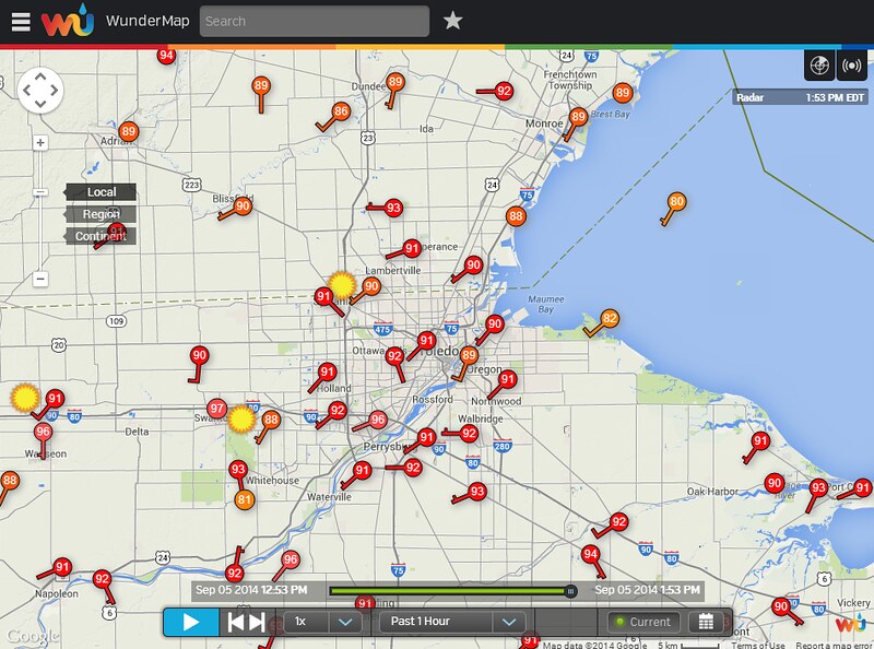
1:53 p.m. Toledo Temps
From the Wundermap.
mesoscale
md 1681 concerning severe potential...watch possible for s lower michigan...nw ohio...n indiana...far ne illinois
mesoscale discussion 1681
nws storm prediction center norman ok
0119 pm cdt fri sep 05 2014
areas affected...s lower michigan...nw ohio...n indiana...far ne
illinois
concerning...severe potential...watch possible
valid 051819z - 051945z
probability of watch issuance...60 percent
summary...strong to severe storms will be possible this afternoon
into the evening hours along and ahead of a cold front.
strong...locally damaging winds will be the main threat but some
hail is also possible. a watch may be needed in the next 1-2 hours.
discussion...temperatures have warmed into the upper 80s to near 90
degrees this afternoon under mostly clear skies. this has resulted
in eroding early inhibition and with dewpoints in the low
70s...strong mlcape approaching 3000 j/kg was noted in 17z
mesoanalysis. furthermore...18z raob from dtx confirms that little
if any inhibition remains over the region...and cumulus was noted in
latest vis sat imagery in the vicinity of a pre-frontal wind
shift/convergence zone. also noted on the 18z dtx raob were
steepening lapse rates above the very moist boundary layer /midlevel
lapse rates near 7-7.5 c per km/ and 0-6 km shear near 30 kt.
convergence along the sewd advancing cold front is weak...but given
degree of instability and other favorable parameters...at least some
semi-organized storm clusters/bowing line segments will be possible
into the evening hours. one or more bands/waves of storms will be
possible...first along any pre-frontal convergent zones and then
further west along the actual cold front itself. steep lapse rates
combined with pw values aoa 1.75 inches will mainly support a
damaging wind threat. while instability and shear will be adequate
for some stronger/briefly rotating updrafts...500 mb temps near -8 c
should limit larger hail potential...but some near-severe hail could
occur in strongest updrafts. area will be monitored for watch
issuance within the next 1-2 hours.
..leitman/corfidi.. 09/05/2014
...please see www.spc.noaa.gov for graphic product...
attn...wfo...cle...dtx...iwx...grr...ind...lot...
lat...lon 43558425 43828299 43698257 43178221 42548232 41498282
41028383 40748564 40548747 40648824 41008865 41368867
41748817 42388679 43558425
Severe Thunderstorm Watch
SEVERE THUNDERSTORM WATCH OUTLINE UPDATE FOR WS 495
NWS STORM PREDICTION CENTER NORMAN OK
305 PM EDT FRI SEP 5 2014
SEVERE THUNDERSTORM WATCH 495 IS IN EFFECT UNTIL 900 PM EDT
FOR THE FOLLOWING LOCATIONS
OHC003-039-043-051-063-069-077-095-123-125-137-143-147-161-171-
173-060100-
/O.NEW.KWNS.SV.A.0495.140905T1905Z-140906T0100Z/
OH
. OHIO COUNTIES INCLUDED ARE
ALLEN DEFIANCE ERIE
FULTON HANCOCK HENRY
HURON LUCAS OTTAWA
PAULDING PUTNAM SANDUSKY
SENECA VAN WERT WILLIAMS
WOOD
Sep 5, 2014 2:52 pm
Weather : Partly Cloudy
Temperature : 93 F
Humidity : 52%
Wind Speed : WSW 12 mph
Barometer : 29.97 in
Dewpoint: 73 F
Visibility : 10.00 statute miles
Heat Index : 102 F
(formerly Metcalf Airport)
Sep 5, 2014 1:53 pm
Weather : Fair
Temperature : 92 F
Humidity : 52%
Wind Speed : SW 14 mph
Barometer : 29.99 in
Dewpoint: 72 F
Visibility : 10.00 statute miles
Heat Index : 100 F
(near Lambertville)
Sep 5, 2014 2:54 pm
Weather : Partly Cloudy
Temperature : 91 F
Humidity : 52%
Wind Speed : SW 9 mph - Gust 16 mph
Barometer : 29.97 in
Dewpoint: 72 F
Visibility : 10.00 statute miles
Heat Index : 98 F
Sep 5, 2014 3:52 pm
Weather : Partly Cloudy
Temperature : 93 F
Humidity : 49%
Wind Speed : WSW 14 mph - Gust 25 mph
Barometer : 29.94 in
Dewpoint: 71 F
Visibility : 10.00 statute miles
Heat Index : 100 F

md 1684 concerning severe thunderstorm watch 495... for nern il...nrn ind...srn mi...nwrn oh...srn lk mi...wrn lk erie
mesoscale discussion 1684
nws storm prediction center norman ok
0536 pm cdt fri sep 05 2014
areas affected...nern il...nrn ind...srn mi...nwrn oh...srn lk
mi...wrn lk erie
concerning...severe thunderstorm watch 495...
valid 052236z - 060000z
the severe weather threat for severe thunderstorm watch 495
continues.
summary...the threat for damaging wind and isolated large hail
continues across svr tstm watch 495 and surrounding areas. a locally
enhanced damaging wind threat will continue across srn mi for the
next 1-2 hrs.
discussion...at 2230z...scattered strong to severe tstms are ongoing
in and near ww 495. the most organized storm structure has been
observed with the ongoing small bow echo now moving across swrn mi.
convection along the srn flank had weakened earlier...but has
recently intensified as it begins to overtake a prefrontal wind
shift where sfc convergence and instability are somewhat stronger.
as this system merges into more scattered convection developing
along and ahead the wind shift...a locally enhanced severe wind risk
will be progress rapidly ewd across srn mi over the next 1-2
hrs...potentially affecting the detroit area by 00z.
further to the southwest...strong to locally severe tstms continue
across nrn indiana and along the cold front in nrn il. sufficient
instability/shear will continue to support a severe threat with this
activity for the next several hours. some uptick in the damaging
wind threat is possible as the frontal convection consolidates over
nrn il and propagates into ongoing convection across nrn ind into
the evening.
..dean.. 09/05/2014
...please see www.spc.noaa.gov for graphic product...
attn...wfo...cle...iln...dtx...iwx...grr...ind...lot...ilx...
lat...lon 40458713 40388824 40808888 41128902 42138778 42808656
43188506 43648257 43328235 43048224 42598225 42238197
41818192 41488194 40948197 40788301 40638415 40528485
40458713
Toledo Express Airport
Sep 5, 2014 5:52 pm
Weather : Fair
Temperature : 92 F
Humidity : 49%
Wind Speed : SW 12 mph - Gust 22 mph
Barometer : 29.89 in
Dewpoint: 70 F
Visibility : 10.00 statute miles
Heat Index : 98 F
TOL:
Sep 5, 2014 6:52 pm
Weather : Fair
Temperature : 89 F
Humidity : 53%
Wind Speed : SW 12 mph - Gust 22 mph
Barometer : 29.89 in
Dewpoint: 70 F
Visibility : 10.00 statute miles
Heat Index : 94 F
special weather statement
national weather service cleveland oh
802 pm edt fri sep 5 2014
ohz003-006-007-060045-
lucas oh-ottawa oh-wood oh-
802 pm edt fri sep 5 2014
...strong thunderstorms moving across northwest ohio and
southeastern michigan...
at 755 pm edt national weather service doppler radar in cleveland
indicated a line of strong thunderstorms from southeast michigan
into portions of northwest ohio. this line will continue to move
east at 30 mph. wind from this line of thunderstorms may gust to
around 45 mph...especially across portions of lucas county.
keep an eye to the sky and move to a safe place if thunderstorms
approach.
please report hail...strong winds or wind damage to the national
weather service.
&&
lat...lon 4172 8387 4174 8345 4172 8342 4170 8342
4169 8337 4172 8334 4163 8315 4175 8310
4174 8309 4163 8314 4154 8301 4146 8309
4146 8333 4150 8334 4150 8341 4117 8342
4117 8389
$$
hazardous weather outlook
hazardous weather outlook
national weather service cleveland oh
803 pm edt fri sep 5 2014
ohz003-006>008-017-018-070015-
lucas-wood-ottawa-sandusky-hancock-seneca-
803 pm edt fri sep 5 2014
...severe thunderstorm watch 495 in effect until 9 pm edt this
evening...
this hazardous weather outlook is for northwest ohio.
.day one...tonight.
please listen to noaa weather radio or go to weather.gov on the
internet for more information about the following hazards.
severe thunderstorm watch.
.days two through seven...saturday through thursday.
no hazardous weather is expected at this time.
.spotter information statement...
spotter activation is not expected at this time.
Sep 5, 2014 7:52 pm
Weather : Fair
Temperature : 86 F
Humidity : 63%
Wind Speed : SW 9 mph
Barometer : 29.90 in
Dewpoint: 72 F
Visibility : 10.00 statute miles
Heat Index : 92 F
(formerly Metcalf Airport)
Sep 5, 2014 7:53 pm
Weather : Fair
Temperature : 86 F
Humidity : 63%
Wind Speed : SSW 14 mph
Barometer : 29.90 in
Dewpoint: 72 F
Visibility : 10.00 statute miles
Heat Index : 92 F
(near Lambertville)
Sep 5, 2014 7:55 pm
Weather : Partly Cloudy
Temperature : 88 F
Humidity : 55%
Wind Speed : SW 9 mph
Barometer : 29.90 in
Dewpoint: 70 F
Visibility : 10.00 statute miles
Heat Index : 93 F

md 1685 concerning severe thunderstorm watch 495... for srn lower mi...nwrn oh...nrn ind...far nern il...wrn lk erie...srn lk huron
mesoscale discussion 1685
nws storm prediction center norman ok
0722 pm cdt fri sep 05 2014
areas affected...srn lower mi...nwrn oh...nrn ind...far nern
il...wrn lk erie...srn lk huron
concerning...severe thunderstorm watch 495...
valid 060022z - 060115z
the severe weather threat for severe thunderstorm watch 495
continues.
summary...primary severe wind threat will be across sern mi until
near or slightly after 01z. a lingering risk will also exist further
to the southwest along the cold front...but this threat is expected
to become increasingly marginal. no additional ww issuance is
currently anticipated.
discussion...at 0015z...an mcs with a history of damaging wind is
moving through far sern lower michigan...including the detroit
area...with a 52 kt wind gust recently observed at dtw. the damaging
wind threat will continue with this system until it clears the state
and progresses into ontario...which should occur by 01z.
further to the southwest...widespread convection continues along a
cold front extending from swrn lower mi into far ern il. these
storms have largely been subsevere thus far...and a gradual
weakening is expected as convection moves into progressively weaker
shear across il/ind and weaker instability in the wake of the mcs
across srn mi. one exception may be across nrn ind where frontal
convection is merging with ongoing prefrontal storms...but any
uptick in this area would likely be short-lived. while convection
will linger beyond the 01z expiration time of ww 495...at this time
the magnitude of the severe threat does not appear to warrant a new
watch or watch extension.
..dean.. 09/06/2014
...please see www.spc.noaa.gov for graphic product...
attn...wfo...cle...dtx...iwx...grr...ind...lot...ilx...
lat...lon 40288794 41038705 41638625 42408460 42778401 43198324
43468274 43098229 42518224 41928239 41568252 41108338
40868463 40288794
special weather statement
national weather service cleveland oh
848 pm edt fri sep 5 2014
ohz003-006>008-060130-
lucas oh-ottawa oh-sandusky oh-wood oh-
848 pm edt fri sep 5 2014
...strong thunderstorms moving across northwest ohio...
at 843 pm edt national weather service doppler radar in cleveland
indicated strong thunderstorms along a line extending from 8 miles
northeast of toledo to 4 miles northeast of waterville to 16 miles
west of custar...moving east at 30 mph. wind gusts up to 45 mph and
small hail will be possible.
some locations that may be impacted by these storms include...
waterville...toledo...bowling green...custar...elmore...port clinton
and fremont.
Sep 5, 2014 8:52 pm
Weather : Thunderstorm Heavy Rain Fog/Mist
Temperature : 71 F
Humidity : 90%
Wind Speed : NW 10 mph - Gust 26 mph
Barometer : 29.94 in
Dewpoint: 68 F
Visibility : 2.50 statute miles
(near Lambertville)
Sep 5, 2014 8:55 pm
Weather : Heavy Rain
Temperature : 72 F
Humidity : 83%
Wind Speed : Calm
Barometer : 29.97 in
Dewpoint: 66 F
Visibility : 7.00 statute miles
fzus51 kcle 051941
nshcle
nearshore marine forecast
national weather service cleveland oh
341 pm edt fri sep 5 2014
for waters within five nautical miles of shore on lake erie
lez142>144-060215-
maumee bay to reno beach oh-reno beach to the islands oh-
the islands to vermilion oh-
341 pm edt fri sep 5 2014
..severe thunderstorm watch 495 in effect until 9 pm edt this
evening...
tonight...southwest winds 5 to 15 knots becoming west 10 knots or
less. mostly cloudy with scattered showers and thunderstorms. waves
1 to 3 feet.
saturday...north winds 5 to 15 knots. numerous showers in the
morning. waves 1 to 3 feet building to 2 to 4 feet.
saturday night...northwest winds 10 knots or less. mostly clear.
waves 1 to 3 feet.
sunday...north winds 10 knots or less becoming northeast. sunny.
waves 2 feet or less.
winds and waves higher in and near thunderstorms.
see lake erie open lakes forecast for monday through wednesday.
the water temperature off toledo is 73 degrees...off cleveland 68 degrees
and off erie 73 degrees.
$$
lez145>149-060215-
vermilion to avon point oh-avon point to willowick oh-
willowick to geneva-on-the lake oh-geneva-on-the-lake to conneaut oh-
conneaut oh to ripley ny-
341 pm edt fri sep 5 2014
tonight...south winds 5 to 15 knots becoming southwest. mostly
cloudy with scattered showers and thunderstorms. waves 1 to 3 feet.
saturday...northwest winds 5 to 15 knots becoming north. numerous
showers in the morning...then scattered showers in the afternoon.
waves 2 to 4 feet.
saturday night...northwest winds 5 to 15 knots becoming northeast
10 knots or less. mostly clear. waves 2 to 4 feet subsiding to 1 to
3 feet.
sunday...northeast winds 10 knots or less. sunny. waves 2 feet or
less.
winds and waves higher in and near thunderstorms.
see lake erie open lakes forecast for monday through wednesday.
the water temperature off toledo is 73 degrees...off cleveland 68 degrees
and off erie 73 degrees.
short term forecast
national weather service cleveland oh
1011 pm edt fri sep 5 2014
ohz003-006>009-060345-
wood oh-lucas oh-ottawa oh-sandusky oh-erie oh-
1011 pm edt fri sep 5 2014
.now...
showers and thunderstorms will affect portions of northwest ohio
through midnight. movement of the showers and thunderstorms will be
east at 25 mph. wind gusts to 40 mph and heavy rainfall can be
expected from these storms.
rainfall amounts around 2 inches will be possible through midnight.
these heavy rains may quickly fill low lying areas such as creeks...
ditches and underpasses. avoid these areas and do not cross flooded
roads.
locations that may be affected include bowling green...clyde...
custar...elmore...fremont...port clinton...sandusky and waterville.
From JR's : articles
3955 words - 25035 chars
- 21 min read
created on
updated on
- #
source
- versions
Related articles
Severe weather threat for Sun, Nov 17, 2013 - Nov 18, 2013
Nov 17, 2013 Toledo area weather notes - Mar 03, 2014
Posts related to Nov 17, 2013 severe weather - Nov 21, 2013
Toledo area weather for early December 2013 - Dec 05, 2013
Mon, Dec 9, 2013 winter storm forecast for Sat, Dec 14 - Dec 14, 2013
more >>