Toledo Weather - Tue, Nov 18, 2014
hazardous weather outlook
national weather service cleveland oh
348 am est tue nov 18 2014
ohz003-006>011-013-017>023-027>033-036>038-047-paz003-190900-
lucas-wood-ottawa-sandusky-erie oh-lorain-cuyahoga-geauga-hancock-
seneca-huron-medina-summit-portage-trumbull-wyandot-crawford-
richland-ashland-wayne-stark-mahoning-marion-morrow-holmes-knox-
crawford pa-
348 am est tue nov 18 2014
this hazardous weather outlook is for north central
ohio...northeast ohio...northwest ohio and northwest pennsylvania.
.day one...today and tonight.
wind chill readings will be zero to 5 below at times through
daybreak wednesday. areas of blowing snow are
possible...especially in and around the snowbelt.
.days two through seven...wednesday through monday.
widespread snow is expected wednesday with more lake effect snow
showers following wednesday night into friday. wind chill readings
wednesday night and thursday night may approach zero.
.spotter information statement...
spotter activation is not expected at this time.
http://toledowinter.com/425/nearrecord-morning-low-temps
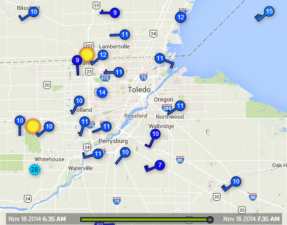
Toledo area personal weather station temps reported to Wundermap as of 7:35 a.m.
TOL: Nov 18, 2014 12:52 am Weather : Fair Temperature : 13 F Humidity : 64% Wind Speed : WSW 18 mph - Gust 26 mph Barometer : 29.89 in Dewpoint: 3 F Visibility : 10.00 statute miles Wind Chill : -4 F
TOL: Nov 18, 2014 1:52 am Weather : Fair and Breezy Temperature : 12 F Humidity : 64% Wind Speed : WSW 21 mph - Gust 26 mph Barometer : 29.89 in Dewpoint: 2 F Visibility : 10.00 statute miles Wind Chill : -7 F
TOL: Nov 18, 2014 6:52 am Weather : Fair Temperature : 10 F Humidity : 73% Wind Speed : SW 20 mph - Gust 26 mph Barometer : 29.95 in Dewpoint: 3 F Visibility : 10.00 statute miles Wind Chill : -9 F
nov 18, 2014 - our backyard temp measured with our digital kitchen thermometer at 8:05 a.m. was 11.5 degrees. TOL: Nov 18, 2014 7:52 am
Weather : Fair
Temperature : 10 F
Humidity : 73%
Wind Speed : SW 17 mph - Gust 28 mph
Barometer : 29.96 in
Dewpoint: 3 F
Visibility : 10.00 statute miles
Wind Chill : -8 F
TOL: Nov 18, 2014 8:52 am Weather : Fair and Breezy Temperature : 12 F Humidity : 70% Wind Speed : SW 21 mph - Gust 29 mph Barometer : 29.98 in Dewpoint: 4 F Visibility : 10.00 statute miles Wind Chill : -7 F
Nov 18, 2014 10:52 am
Weather : Overcast and Breezy
Temperature : 16 F
Humidity : 65%
Wind Speed : WSW 23 mph - Gust 35 mph
Barometer : 30.01 in
Dewpoint: 6 F
Visibility : 10.00 statute miles
Wind Chill : -2 F
Toledo 7-day forecast
Last Update: Nov 18, 2014 10:05 am
This Afternoon: A slight chance of snow showers. Mostly cloudy, with a high near 18. Wind chill values as low as -3. Breezy, with a west wind 20 to 22 mph, with gusts as high as 33 mph. Chance of precipitation is 20%.
Tonight: A slight chance of snow showers after 4am. Mostly cloudy, with a low around 11. Wind chill values as low as -1. West wind 9 to 13 mph. Chance of precipitation is 20%.
Wednesday: Snow showers likely, mainly after noon. Cloudy, with a high near 31. Wind chill values as low as zero. Breezy, with a south wind 8 to 13 mph increasing to 16 to 21 mph in the afternoon. Chance of precipitation is 70%. New snow accumulation of 1 to 2 inches possible.
Wednesday Night: A chance of snow showers, mainly before 8pm. Mostly cloudy, with a low around 16. Southwest wind 14 to 18 mph, with gusts as high as 28 mph. Chance of precipitation is 30%.
Thursday: A slight chance of snow showers after 8am. Partly sunny, with a high near 24. Southwest wind 13 to 18 mph, with gusts as high as 28 mph. Chance of precipitation is 20%.
Thursday Night: A slight chance of snow showers. Mostly cloudy, with a low around 11. Chance of precipitation is 20%.
Friday: Mostly sunny, with a high near 26.
Friday Night: Partly cloudy, with a low around 16.
Saturday: A chance of showers. Mostly cloudy, with a high near 40. Chance of precipitation is 30%.
Saturday Night: A chance of showers. Mostly cloudy, with a low around 37. Chance of precipitation is 40%.
Sunday: Showers likely. Cloudy, with a high near 49. Chance of precipitation is 70%.
Sunday Night: Showers likely. Cloudy, with a low around 43. Chance of precipitation is 70%.
Monday: A chance of showers. Cloudy, with a high near 50. Chance of precipitation is 50%.
fxus61 kcle 181525
afdcle
area forecast discussion
national weather service cleveland oh
1025 am est tue nov 18 2014
synopsis...
a trough of low pressure over the eastern great lakes will weaken
today and allow high pressure to move up the ohio valley tonight. a
cold front will move east across the region early wednesday night
then high pressure will push northeast across the area late friday
and off the east coast saturday. a low will move out of the southern
plains sunday and across the lakes monday pulling a cold front
through the area.
&&
near term /until 6 pm this evening/...
a trough aloft will move across the area today. the big issue is
the snow band over lake erie that is oriented se to nw. after this
trough moves through this afternoon the band is expected to move
inland. the main impact will be erie county pa and the extreme ne
portion of lake county and the ashtabula county lakeshore.
elsewhere it will become partly to mostly cloudy with a threat of
isolated snow showers.
previous discussion...
lake effect shsn and blsn will remain the issues in the snowbelt
into tonight while other areas may see wind chill readings getting
down to minus 5 to 8 this morning and almost as cold late tonight.
the current lake effect warnings for the lakeshore counties of ne oh
and erie co pa still look like the right way to go so not planning
to change things. as an upper s/w moves in this evening...there
should be some enhancement and southward push to the lake effect
bands that should result in some snow further inland around the
snowbelt.
highs today will stay well below normal with readings only topping
out from the upper teens to lower 20s. a few flurries could occur in
areas outside the snowbelt.
&&
short term /6 pm this evening through thursday night/...
as mentioned above...will be leaving the lake effect warning going
until 7 am wed..when winds have started to back enough to start
turning the bands of snow more offshore. its possible erie co pa
lakeshore may need an extension of the warning if winds end up
backing a little slower than expected.
the dry weather will only last a few hours at most on wed. another
cold front quickly moves into the area by late wed as another s/w
dives into the main upper trough. sw winds ahead of the front will
moderate the temps on wed with highs possibly screaming all the way
up to the freezing point. this will be short-lived as another piece
of arctic air spread back in behind the front for wed night and thu.
warm advective lift may cause a few flurries to occur late tue night
from lingering moisture around 850 mb. otherwise...a band of mainly
light snow should develop nw to se on wed. the widespread snow
should be coming to an end in the east wed evening then more lake
effect shsn will occur. the wind thru the lower level take a while
wed night into thu to turn from sw to more west so it may take a
while for the better bands of lake effect to pivot onshore. for this
reason will keep accumulation on the lighter side wed night and
defer any headlines for this. besides...lets try and get thru the
current event.
&&
long term /friday through monday/...
the upper trough is progged to pull out by the end of the week. as
the surface high slides east...the winds will come around from the
south by friday night and saturday. i suspect the warm up will be
rather dramatic...especially compared to the weather all week
leading up to it. the new extended forecast will be about 6-12 hours
faster ending the lake effect snow on friday and then the warm up on
saturday. it will be hard to get the timing correct since we are
still 5-6 days away but temps will probably start to rise later
friday or friday night and may just keep rising through the weekend.
from highs on friday in the mid/upper 20s to around 40 on saturday
to the 50s on sunday. the chances for showers will increase through
the weekend with the warm advection and especially by sunday as a
leading short wave comes out of the southwest.
&&
aviation /12z tuesday through saturday/...
lake effect snow will remain over lake erie and along the east
lakeshore affecting only the taf forecast at keri where ifr
conditions will likely occur much of the time today. elsewhere
areas of mvfr and vfr ceilings (bkn025-035) will develop. a few
flurries are likely which may briefly reduce visibility but did
not mention it in the taf forecasts since they will be brief and
the timing is uncertain. strong wsw winds will cause blowing snow
at times. vfr conditions will return tonight with mid and high
clouds increasing during the early morning hours on wednesday.
outlook...non vfr conditions at times wednesday afternoon/evening
with snow showers with the next cold front. lake effect snow
will return thursday into friday over extreme ne oh/nw pa.
&&
marine...
a gale warning remains in effect on lake erie through this evening.
the west southwest flow along with strong cold advection and
pressure rises will continue to bring gales. winds should peak today
between 35 and 40 knots then gradually diminish tonight. low water
will continue on the western basin. will extend the low water
advisory through much of tuesday night. waters levels will slowly
rise tonight with the decreasing wind speeds and the timing of the
natural seiche. winds should back to south on wednesday ahead of the
next strong cold front. there is a chance for brief gales wednesday
night with the passage of the cold front but if it occurs it should
be short lived and transition up the lake. will keep the forecast at
30 knots for now. high pressure will build across the lake by the
weekend and things should settle down. the flow will back to
southwest by saturday but with the atmosphere warming...the wind
will not mix as well and wind speeds should remain light to moderate.
&&
cle watches/warnings/advisories...
oh...lake effect snow warning until 7 am est wednesday for ohz012-
014-089.
pa...lake effect snow warning until 7 am est wednesday for paz001-
002.
marine...gale warning until 10 pm est this evening for lez061-142>149-
162>169.
low water advisory until 4 am est wednesday for lez142>144-
162>164.
&&
$$
synopsis...adams
near term...adams/kieltyka
short term...adams
long term...kosarik
aviation...kosarik
marine...kosarik
From JR's : articles
1824 words - 10581 chars
- 10 min read
created on
updated on
- #
source
- versions
Related articles
Severe weather threat for Sun, Nov 17, 2013 - Nov 18, 2013
Nov 17, 2013 Toledo area weather notes - Mar 03, 2014
Posts related to Nov 17, 2013 severe weather - Nov 21, 2013
Toledo area weather for early December 2013 - Dec 05, 2013
Mon, Dec 9, 2013 winter storm forecast for Sat, Dec 14 - Dec 14, 2013
more >>