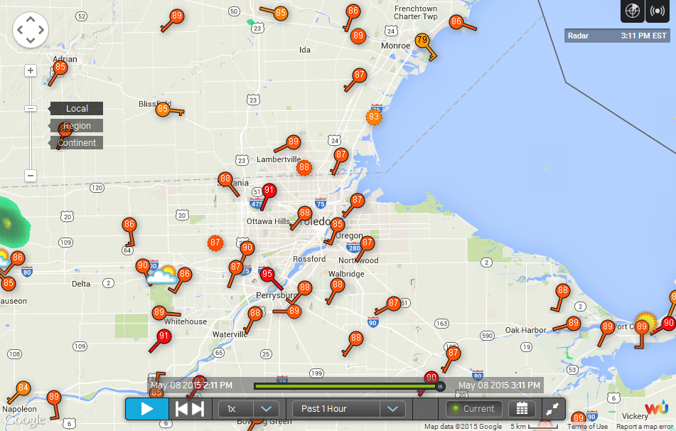
• Toledo Area Airports
• Around 2pm
• Around 3pm
• Forecast.io
• Forecast
• AFD
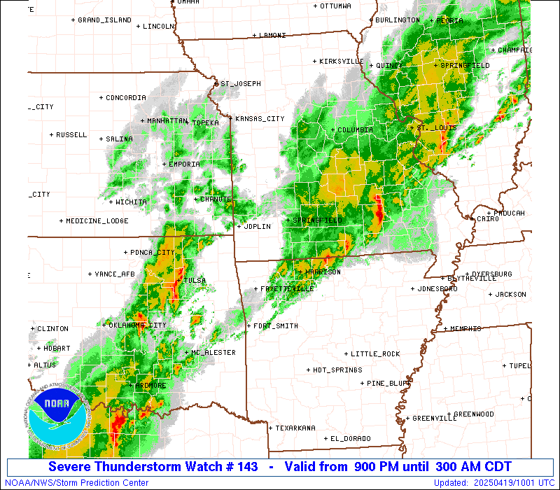
• Severe Threat in OK and TX
Fri, May 8, 2015 Toledo Weather
Partly cloudy, warm, breezy afternoon. Toledo area temps were in the mid to upper 80s at mid-afternoon. But dewpoints were in the 50s, so decent humidity levels.
Wundermap Stations
At 3:12 p.m., the LTWS station reported 91 and the WTWS reported 88.
Toledo Area Airports
Around 2pm
Toledo Express
May 8, 2015 1:52 pm
Weather : A Few Clouds
Temperature : 85 F
Humidity : 37%
Wind Speed : SSW 8 mph - Gust 24 mph
Barometer : 30.01 in
Dewpoint: 56 F
Visibility : 10.00 statute miles
Toledo Executive
May 8, 2015 1:53 pm
Weather : A Few Clouds
Temperature : 86 F
Humidity : 32%
Wind Speed : SW 14 mph - Gust 22 mph
Barometer : 30.02 in
Dewpoint: 53 F
Visibility : 10.00 statute miles
Toledo Suburban
May 8, 2015 2:35 pm
Weather : Partly Cloudy
Temperature : 88 F
Humidity : 31%
Wind Speed : SW 12 mph - Gust 17 mph
Barometer : 30.00 in
Dewpoint: 54 F
Visibility : 10.00 statute miles
Around 3pm
Express
May 8, 2015 2:52 pm
Weather : A Few Clouds
Temperature : 86 F
Humidity : 36%
Wind Speed : SSW 14 mph - Gust 21 mph
Barometer : 29.98 in
Dewpoint: 56 F
Visibility : 10.00 statute mile
Executive
May 8, 2015 2:53 pm
Weather : A Few Clouds
Temperature : 88 F
Humidity : 30%
Wind Speed : SW 13 mph - Gust 23 mph
Barometer : 29.99 in
Dewpoint: 53 F
Visibility : 10.00 statute miles
Suburban
May 8, 2015 2:55 pm
Weather : Partly Cloudy
Temperature : 86 F
Humidity : 33%
Wind Speed : S 13 mph
Barometer : 29.99 in
Dewpoint: 54 F
Visibility : 10.00 statute miles
Forecast.io
As of 3:03 p.m. EDT
Toledo Area Forecast Summaries
(using forecast.io data)
Now: Partly Cloudy 86 F - SSW at 8 mph
Next 24 Hours: Light rain starting tomorrow morning.
Next 7 Days: Light rain tomorrow through Tuesday, with temperatures falling to 57�F on Wednesday.
Weather for Toledo More at Forecast.io
86� and falling
Partly Cloudy
Wind: 8 mph (SW)
Today
86� 60�
Sat
78� 64�
Sun
75� 62�
Mon
79� 65�
Tue
70� 50�
Wed
57� 40�
Thu
60� 44�
Fri
65� 47�
Forecast
Toledo 7-day forecast
Last Update: May 8, 2015 2:21 pm
This Afternoon: A slight chance of showers and thunderstorms. Partly sunny, with a high near 85. Southwest wind around 13 mph. Chance of precipitation is 20%.
Tonight: A chance of showers and thunderstorms. Mostly cloudy, with a low around 63. South wind 3 to 6 mph. Chance of precipitation is 40%. New rainfall amounts of less than a tenth of an inch, except higher amounts possible in thunderstorms.
Saturday: Showers and thunderstorms likely, mainly after noon. Mostly cloudy, with a high near 82. Light and variable wind becoming southwest 9 to 14 mph in the morning. Chance of precipitation is 60%. New rainfall amounts between a quarter and half of an inch possible.
Saturday Night: A chance of showers and thunderstorms. Mostly cloudy, with a low around 62. Southwest wind around 5 mph becoming calm in the evening. Chance of precipitation is 50%. New rainfall amounts between a tenth and quarter of an inch, except higher amounts possible in thunderstorms.
Sunday: A chance of showers and thunderstorms. Mostly cloudy, with a high near 80. Calm wind becoming south 5 to 9 mph in the morning. Chance of precipitation is 50%. New rainfall amounts between a tenth and quarter of an inch, except higher amounts possible in thunderstorms.
Sunday Night: Showers and thunderstorms likely. Mostly cloudy, with a low around 63. Chance of precipitation is 60%. New rainfall amounts between a tenth and quarter of an inch, except higher amounts possible in thunderstorms.
Monday: Showers and thunderstorms likely. Mostly cloudy, with a high near 80. Chance of precipitation is 60%.
Monday Night: Showers and thunderstorms likely. Mostly cloudy, with a low around 56. Chance of precipitation is 70%.
Tuesday: Partly sunny, with a high near 62. Breezy.
Tuesday Night: Mostly cloudy, with a low around 41.
Wednesday: Partly sunny, with a high near 58.
Wednesday Night: Partly cloudy, with a low around 40.
Thursday: Mostly sunny, with a high near 61.
AFD
fxus61 kcle 081756
afdcle
area forecast discussion
national weather service cleveland oh
156 pm edt fri may 8 2015
synopsis...
an upper level ridge will continue to dominate the weather across
the region today. a frontal boundary will approach the local area
from the northwest on saturday and then stall near lake erie
saturday night or sunday. the front will move back north as a warm front
early next week as an area of strong low pressure moves from the
central plains to northern great lakes.
&&
near term /through tonight/...
update...no big changes for the afternoon update.
original...skies remain mostly clear this morning. another warm
summer like day is in store for the area. a couple of record highs
will be challenged or broken today. 850 mb temps are forecast to
be just a tad cooler than thursday. but given a warmer start
expect high temps to be fairly close to yesterdays values inland
areas. there should be enough of a pressure gradient to keep the
lake breeze fairly close to the shoreline today so places like
kbkl and keri should be a handful of degrees warmer than thursday.
surface dewpoints currently are not as high as progged by the
guidance but should come up some today. really not much in the way
of forcing today but some weak low level moisture convergence
could kick off some showers or storms over far nw ohio. a few
storms could also fire along the lake breeze boundary east of kcle
later today. some of newer guidance including the latest hrrr pick
up on that scenario. the previous forecast already had a mention
so will stick with it for now.
&&
short term /saturday through monday night/...
the frontal system over the western great lakes will continue to
inch toward the local area the next couple of days. as this
happens precip chances will increase from northwest to southeast.
very little shear and upper support expected over the weekend so
no organized convection is expected. the showers and storms that
do develop will likely be scattered in nature. right now it
appears best chances for widespread precip will probably not come
till later monday and monday night. till then will need mainly likely
pops in nw ohio with no more than chance of scattered wording
across the remainder of the area. it's still tough to tell if the
front will make it across the lake before it stalls on sunday. the
new guidance continues to show an area of strong low pressure
developing over the plains this weekend. this low will move to the
northern lakes on monday causing the front to lift back to the
north. as this happens the local area could see a 12 to 18 hour
period of mainly dry weather. the more widespread precip mentioned
above will come as the trailing cold front finally approaches late
in the short term period. it has been fairly dry so far this month
but think most of the area will see at least a half inch of
precip the next few days. temps will remain a good 15 degrees
above normal during the period with highs mainly in the lower to
middle 80s.
&&
long term /tuesday through thursday/...
both the ecmwf and gfs track low pressure system across the eastern
lakes tuesday...then off the new england coast on wednesday. behind
the front much colder air spills over the area. gfs continues to be
much colder than the latest ecmwf. by wednesday evening the gfs
850 mb temperatures plunge to -4c while the ecmwf only to +4c. for
now will continue to spit the difference on the temps.
&&
aviation /18z friday through wednesday/...
vfr conditions in place to start the taf cycle with cumulus clouds
developing around 6k feet. moisture is increasing from the west and
a few showers or isolated thunderstorms may try to sneak into the
tol area after 21z. better chances will be after 06z as moisture
continues to increase. an isolated shower or thunderstorm will also
be possible in northeast oh/northwest pa this afternoon but chances
of impacting a terminal are too low to include in any forecasts at
this time. mvfr visibilities may develop late tonight...mainly in nw
ohio as dewpoints continue to increase. otherwise scattered showers
and thunderstorms expected during the afternoon/evening on saturday.
outlook...non vfr possible in showers and thunderstorms saturday
afternoon through monday night.
&&
marine...
light south flow over the lake will continue through the weekend as
high pressure remains over the eastern lakes. southwest winds will
increase monday night and tuesday ahead of a low pressure system
moves into the central lakes. trailing cold front will move across
lake erie on tuesday. a small craft advisory will likely be needed
for tuesday and tuesday night.
&&
cle watches/warnings/advisories...
oh...none.
pa...none.
marine...none.
&&
$$
synopsis...kubina
near term...tk/kubina
short term...kubina
long term...djb
aviation...kec
marine...djb
Severe Threat in OK and TX
Multi-day event of severe weather in this region, and it will continue into Saturday.
http://www.wunderground.com/blog/JeffMasters/comment.html?entrynum=2979
Yesterday, the SPC included northwest OH in the 15 percent area for severe weather for Mon, May 11. That outlook continued in today's forecast.
http://www.spc.noaa.gov/products/watch/ww0143.html
http://www.wunderground.com/radar/radblast.asp?ID=FDR
The National Weather Service in Norman has issued a
- Tornado Warning for...
southwestern Cotton County in southwestern Oklahoma...
southern Tillman County in southwestern Oklahoma...
northern Wichita County in northern Texas...
east central Wilbarger County in northern Texas...
- until 545 PM CDT
- at 505 PM CDT... a confirmed tornado was located near Oklaunion...
moving east at 40 mph.
Hazard... damaging tornado and Golf Ball size hail.
Source... emergency management confirmed tornado.
Impact... flying debris will be dangerous to those caught without
shelter. Mobile homes will be damaged or destroyed.
Damage to roofs... windows and vehicles will occur. Tree
damage is likely.
- Locations impacted include...
northwestern Wichita Falls... Burkburnett... Iowa Park... Electra...
Grandfield... Davidson... Devol... Harrold... Oklaunion... Pleasant
Valley and Haynesville.
Precautionary/preparedness actions...
To repeat... a tornado is on the ground. Take cover now! Move to a
storm shelter... safe room or an interior room on the lowest floor of
a sturdy building. Avoid windows. If in a Mobile home... a vehicle or
outdoors... move to the closest substantial shelter and protect
yourself from flying debris.
Heavy rainfall may hide this tornado. Do not wait to see or hear the
tornado. Take cover now.
Lat... Lon 3399 9916 3425 9917 3432 9859 3411 9853
3392 9862
time... Mot... loc 2205z 272deg 33kt 3412 9909
Tornado... observed
hail... 1.75in
Kurtz
Tornado Warning
Statement as of 5:08 PM CDT on May 08, 2015
The National Weather Service in San Angelo has issued a
- Tornado Warning for...
northern Haskell County in west central Texas...
- until 600 PM CDT
- at 506 PM CDT... a severe thunderstorm capable of producing a
tornado was located 12 miles west of Rochester... and moving east at
30 mph.
Hazard... tornado... Golf Ball size hail and 70 mph wind gusts.
Source... radar indicated rotation.
Impact... flying debris will be dangerous to those caught without
shelter. Mobile homes will be damaged or destroyed. Damage
to roofs... windows and vehicles will occur. Tree damage is
likely.
- This dangerous storm will be near...
Rochester around 525 PM CDT.
O'Brien around 530 PM CDT.
Weinert around 545 PM CDT.
Other locations in the warning include Jud and US-277 near the
Haskell-Knox County line.
Precautionary/preparedness actions...
Take cover now. Move to an interior room on the lowest floor of a
sturdy building. Avoid windows. If in a Mobile home... a vehicle or
outdoors... move to the closest substantial shelter and protect
yourself from flying debris.
Lat... Lon 3310 9952 3308 9989 3309 10000 3339 10000
3340 9999 3341 9952
time... Mot... loc 2208z 270deg 28kt 3337 10003
Tornado... radar indicated
hail... 1.75in
Tornado Warning
Statement as of 5:21 PM CDT on May 08, 2015
... A Tornado Warning remains in effect until 545 PM CDT for
southwestern Cotton... southeastern Tillman... northern Wichita and
east central Wilbarger counties...
at 520 PM CDT... a severe thunderstorm capable of producing a tornado
was located 6 miles north of Electra... moving east at 35 mph.
Hazard... tornado and Golf Ball size hail.
Source... radar indicated rotation.
Impact... flying debris will be dangerous to those caught without
shelter. Mobile homes will be damaged or destroyed. Damage
to roofs... windows and vehicles will occur. Tree damage is
likely.
Locations impacted include...
Burkburnett... Iowa Park... Electra... Grandfield... Devol and
Haynesville.
Precautionary/preparedness actions...
Take cover now! Move to a storm shelter... safe room or an interior
room on the lowest floor of a sturdy building. Avoid windows. If in a
Mobile home... a vehicle or outdoors... move to the closest substantial
shelter and protect yourself from flying debris.
Heavy rainfall may hide this tornado. Do not wait to see or hear the
tornado. Take cover now.
Lat... Lon 3401 9898 3422 9899 3428 9858 3411 9853
3395 9861
time... Mot... loc 2220z 268deg 31kt 3412 9891
Tornado... radar indicated
hail... 1.75in
Severe Thunderstorm Warning
Statement as of 5:53 PM CDT on May 08, 2015
... A Severe Thunderstorm Warning remains in effect until 645 PM CDT
for Cotton... western Jefferson... southeastern Tillman... southwestern
Stephens... northeastern Archer... Wichita and northern Clay
counties...
At 552 PM CDT... severe thunderstorms were located along a line
extending from near Cookietown to near Devol to near Burkburnett to 4
miles northwest of Sheppard AFB to 4 miles south of Iowa Park...
moving east at 35 mph.
These are very dangerous storms.
Hazard... 80 mph wind gusts and Golf Ball size hail.
Source... radar indicated.
Impact... flying debris will be dangerous to those caught without
shelter. Mobile homes will be heavily damaged. Expect
considerable damage to roofs... windows and vehicles.
Extensive tree damage and power outages are likely.
Locations impacted include...
Wichita Falls... Burkburnett... Henrietta... Walters... Waurika... Iowa
Park... Electra... Comanche... Grandfield... Temple... Ryan... Petrolia...
Byers... Dean... Randlett... Terral... Jolly... Devol... Hastings and
Addington.
Precautionary/preparedness actions...
A Tornado Watch remains in effect for the warned area. Tornadoes can
develop quickly from severe thunderstorms.
For your protection move to an interior room on the lowest floor of a
building.
This is a dangerous situation. These storms are producing widespread
wind damage across northern Wichita County. Seek shelter now inside
a sturdy structure and stay away from windows.
Lat... Lon 3390 9895 3402 9893 3413 9887 3415 9887
3436 9875 3437 9796 3413 9779 3386 9790
3389 9798 3378 9798 3373 9823
time... Mot... loc 2252z 279deg 29kt 3429 9848 3418 9855 3410 9855 3402
9857 3389 9869
Hail... 1.75in
wind... 80mph
Kurtz
http://www.spc.noaa.gov/products/watch/ww0143_radar_big.gif
http://www.spc.noaa.gov/products/watch/ww0143_warnings.gif
http://streema.com/radios/Wichita_Falls_TX
From JR's : articles
2454 words - 15564 chars
- 13 min read
created on
updated on
- #
source
- versions
Related articles
Severe weather threat for Sun, Nov 17, 2013 - Nov 18, 2013
Nov 17, 2013 Toledo area weather notes - Mar 03, 2014
Posts related to Nov 17, 2013 severe weather - Nov 21, 2013
Toledo area weather for early December 2013 - Dec 05, 2013
Mon, Dec 9, 2013 winter storm forecast for Sat, Dec 14 - Dec 14, 2013
more >>