• Severe Weather Summary
• Early a.m. CO
• SPC CO May 7-11
• 8:00 a.m. images
• Forecast
• AFD
• Mid-morning HWO
• N. IN. AFD
• Det/Pon AFD
• Noon Time weather
• MD
• Tornado Watch
• Early PM CO
• Early PM Notes
• Warnings and Watches
• Lucas County Tstrm
• Another MD
• Storm Report
Toledo Weather - Mon, May 11, 2015
hazardous weather outlook
national weather service cleveland oh
422 am edt mon may 11 2015
for lake erie...north central
ohio...northeast ohio...northwest ohio and northwest pennsylvania.
.day one...today and tonight.
there is a slight risk for severe thunderstorms today and early
tonight. the primary threat will be strong damaging winds and
large hail.
.days two through seven...tuesday through sunday.
no hazardous weather is expected at this time.
.spotter information statement...
spotter activation is not expected at this time.
$$
Toledo Airport Conditions
Toledo Express
May 11, 2015 5:52 am
Weather : Fog/Mist
Temperature : 64 F
Humidity : 96%
Wind Speed : Calm
Barometer : 29.93 in
Dewpoint: 63 F
Visibility : 5.00 statute miles
External Link : 3-day history
(formerly Metcalf Airport)
May 11, 2015 5:53 am
Weather : Partly Cloudy
Temperature : 66 F
Humidity : 90%
Wind Speed : S 5 mph
Barometer : 29.94 in
Dewpoint: 63 F
Visibility : 10.00 statute miles
(near Lambertville)
May 11, 2015 6:35 am
Weather : Fog/Mist
Temperature : 63 F
Humidity : 94%
Wind Speed : Calm
Barometer : 29.94 in
Dewpoint: 61 F
Visibility : 1.25 statute miles
TOL:
May 11, 2015 6:52 am
Weather : Fog/Mist
Temperature : 65 F
Humidity : 97%
Wind Speed : SSW 5 mph
Barometer : 29.95 in
Dewpoint: 64 F
Visibility : 6.00 statute miles
TOL:
May 11, 2015 7:52 am
Weather : Fair
Temperature : 66 F
Humidity : 87%
Wind Speed : SW 8 mph
Barometer : 29.97 in
Dewpoint: 62 F
Visibility : 10.00 statute miles
TOL:
May 11, 2015 8:52 am
Weather : Fair
Temperature : 68 F
Humidity : 81%
Wind Speed : SSW 6 mph
Barometer : 29.97 in
Dewpoint: 62 F
Visibility : 10.00 statute miles
(formerly Metcalf Airport)
May 11, 2015 8:53 am
Weather : Fair
Temperature : 70 F
Humidity : 76%
Wind Speed : SW 12 mph
Barometer : 29.99 in
Dewpoint: 62 F
Visibility : 10.00 statute miles
(near Lambertville)
May 11, 2015 8:54 am
Weather : Fair
Temperature : 70 F
Humidity : 78%
Wind Speed : SW 5 mph
Barometer : 29.98 in
Dewpoint: 63 F
Visibility : 10.00 statute miles
Severe Weather Summary
Areas with the best chance for severe weather
- northeast Indiana
- southern Michigan
- northwest Ohio
Main window for severe weather
- between 3:00 p.m. and 9:00 p.m.
- first line: between 4:00 p.m. and 6:00 p.m.
- second line: between 6:00 p.m. and 8:00 p.m.
Primary threats
- Thunderstorm wind gusts of 60-plus mph, capable of downing trees and wires and possibly causing structural damage.
- Brief but torrential rainfall, capable of producing flash flooding.
Secondary threats
- Hail at least 3/4-inch in diameter
- Small tornadoes
Key ingredient
- Amount of sunshine this morning and early this afternoon.
- If the sky clears this morning, and we have a mostly sunny day, then our temps will warm into the low to mid 80s with dew points in the mid 60s, and the severe threat increases. The storm strength will depend upon the other atmospheric variables.
- At 6:00 a.m., our sky cover was at least 80%, comprised of low and mid level clouds. Muggy walk.
- At 8:00 a.m., our sky cover was around 50%. High and mid level cloudiness. Mostly sunny sky.
Storm Prediction Center
- As of early this morning our region was still under a Slight Risk for severe weather. The SPC will issue an updated convective outlook later this morning. We'll know then if our area will be upgraded to an Enhanced Risk.
- If conditions warrant, I'm guessing that the SPC will issue a Mesoscale Discussion for the region between Noon and 3:00 p.m. The MD will mention the likelihood of a watch being issues.
- If a watch is issued, I'm guessing that it will be issued between 1:00 and 3:00 p.m.
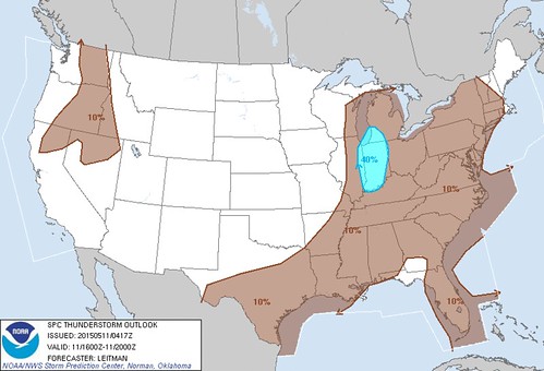
Early a.m. CO
spc ac 110518
day 1 convective outlook
nws storm prediction center norman ok
1218 am cdt mon may 11 2015
valid 111200z - 121200z
...there is a slgt risk of svr tstms across parts of the srn
plains...lower to mid ms valley...tn valley...oh valley...sern great
lakes...
...there is a mrgl risk of svr tstms across parts of the srn
plains...lower to mid ms valley...tn valley...oh valley...sern great
lakes...
...there is a mrgl risk of svr tstms across parts of ern nc...
...summary...
scattered thunderstorms are expected to develop along and ahead of a
cold front from lower michigan to central texas. isolated damaging
winds and hail will be possible with the stronger thunderstorms. a
couple tornadoes may occur in the southern great lakes region.
...srn great lakes/oh valley/mid ms valley...
an upper-level trough will move into the mid mo valley today as a
cold front advances ewd across the mid to upper ms valley.
thunderstorms will likely be ongoing ahead of the front in the mid
ms valley at the start of the period. this activity is forecast to
spread quickly newd across the lower oh valley into the srn great
lakes region by early afternoon. a corridor of instability is
forecast to develop ahead of this convection by early afternoon from
ern indiana and ohio nwd into sern lower mi. forecast soundings from
nrn oh nwd to near detroit mi at 21z show sfc dewpoints in the lower
60s f contributing to sbcape near 1500 j/kg. in
addition...directional shear is present from the sfc to 700 mb with
wind speeds increasing with height in the mid levels...creating
moderate deep-layer shear. this should be favorable for rotating
storms and possibly a couple tornadoes as a 40 to 55 kt low-level
jet moves across the region during the mid to late afternoon.
rotating storms and organized line segments may also produce wind
damage.
further to the east across much of new york...the models develop an
east-to-west axis of instability along and just to the south of a
warm front. scattered thunderstorm development should take place
along the front during the afternoon. instability may be enough
combined with unidirectional wind profiles for marginally severe
wind gusts.
...srn plains/arklatex/lower ms valley...
the srn extent of an upper-level trough will move ewd across the srn
plains today as a cold front advances sewd into the arklatex and tx
hill country. ahead of the boundary...sfc dewpoints from the mid 60s
to the lower 70s f should be in place...contributing to moderate to
strong destabilization by afternoon. thunderstorm development should
take place along and ahead from the front from the tx hill country
ewd into the lower ms valley. forecast soundings along this corridor
at 00z/tue show mlcape values generally in the 2000 to 2500 j/kg
range with 30 to 35 kt of deep-layer shear. this combined with steep
lapse rates should be favorable for some severe storms with
large-hail potential. supercells will be possible where deep-layer
shear becomes locally enhanced but multicells are expected to be the
most common storm type. in addition to the hail threat...a
wind-damage threat should exist with storms that rotate and the more
persistent line segments.
...ern nc...
tropical depression ana is forecast to move newd from ne nc into
sern va this morning. strong wind fields to the east of the center
may be enough for marginally severe wind gusts with convection that
develops across the cape hatteras area and further inland across ne
nc.
..broyles/leitman.. 05/11/2015
click to get wuus01 ptsdy1 product
note: the next day 1 outlook is scheduled by 1300z
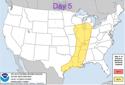
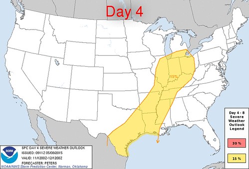
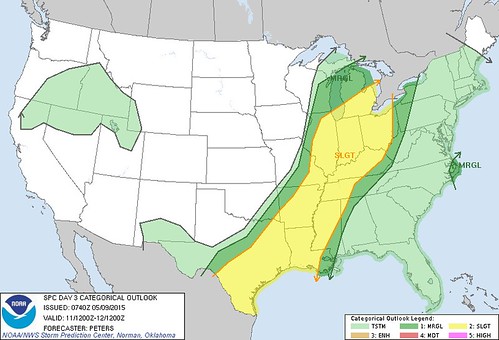
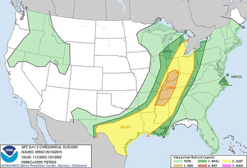
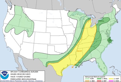
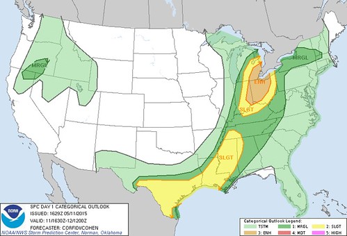
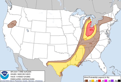
SPC CO May 7-11
All of these convective outlooks were for Mon, May 11. The SPC has shown northwest Ohio to be in the risk of severe weather since Thu, May 7.
Day 5 convective outlook issued on Thu, May 7 for Mon, May 11
Day 4 convective outlook issued on Fri, May 8 for Mon, May 11
Day 3 convective outlook issued on Sat, May 9 for Mon, May 11
Day 2 convective outlook issued on Sun, May 10 for Mon, May 11
Day 1 convective outlook issued on Mon, May 11 for Mon, May 11
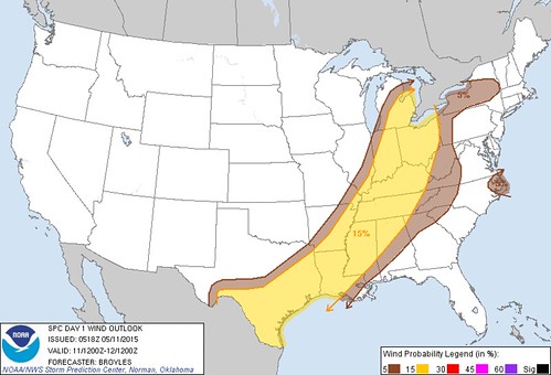
Wind outlook
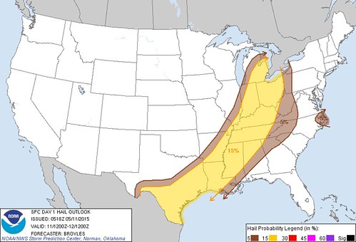
Hail outlook
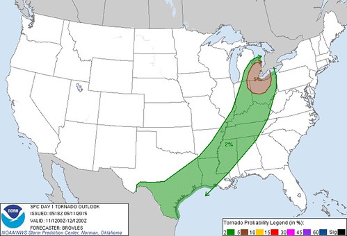
Tornado outlook
Thunderstorm outlook between 12:00 p.m. and 4:00 p.m.
Thunderstorm outlook between 4:00 p.m. and 8:00 p.m.
Updated Day 1 Convective Outlook. No upgrade to enhanced.
Map of low pressures and fronts. Good migrating songbird activity around our home this morning. The weather may have made for a big movement overnight. Need to check BSBO banding data to see how big today ends up being.
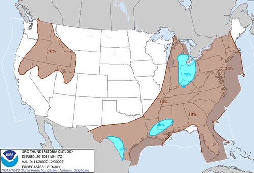
spc ac 111253
day 1 convective outlook
nws storm prediction center norman ok
0753 am cdt mon may 11 2015
valid 111300z - 121200z
...there is a slgt risk of svr tstms portions sern lower
mi...oh...indiana...nrn ky...
...there is a slgt risk of svr tstms portions mid south across lower
ms valley to s tx...
...there is a mrgl risk of svr tstms elsewhere from s tx to portions
wrn/nrn ny...
...summary...
scattered thunderstorms are expected to develop along and ahead of a
cold front over parts of lower michigan to the ohio valley...as well
as from the mid south to south texas. damaging winds and hail will
be possible with the stronger thunderstorms. a couple of tornadoes
may occur in the southern great lakes region.
...synopsis...
progressive mid/upper-level pattern is fcst through
period...featuring cyclones now evident in moisture-channel imagery
over ern dakotas and offshore pac nw. nrn-plains cyclone is
expected to move generally ewd across mn today...devolving into
open-wave trough tonight across wi. this will occur as accompanying
shortwave trough now over central high plains pivots ewd over ks/neb
then newd across lm and lower mi...and another perturbation pivots
sewd/ewd out of black hills region and across mid-upper ms valley.
pac cyclone will move sewd to swrn ore and nwrn ca through
period...and srn-stream perturbation now seen off baja will eject
enewd across nwrn mex toward far w tx and big bend region.
at sfc...cyclone now over srn mn is expected to move enewd across
wrn/nrn wi by 00z...then occlude...with new low ejecting enewd
across swrn que during 09-12z time frame. cold front...now extending
from upper ms valley across ozarks to central/sw tx...is preceded
along much of its length by convectively generated
outflow/baroclinic boundary that is evident from srn il to nrn la
and se tx. front itself should decelerate over s-central/se
tx...perhaps merging with prefrontal boundary this aftn or
overnight. cold front should move ewd to lower mi...indiana and
central/ern ar by 00z...then to ern ny...central/srn appalachians
and central ms around end of period. warm front should move nwd
today through parts of wi...lm and lower mi ahead of sfc
cyclone...and more slowly move nwd across wrn/nrn ny.
...s tx to lower ms valley...
ref spc ww 163 and related mesoscale discussions for near-term info
on svr threat over s tx.
additional svr-tstm development is possible today over this corridor
as air mass destabilizes in preconvective sector...including
potential re-intensification of currently/mostly anafrontal squall
line now evident from sern ar to se tx. damaging wind will be
possible...and large-hail threat increases with wwd extent across s
tx in proximity to steeper deep-layer lapse rates and larger diurnal
cape.
although mid/upper-level trough will be ejecting away from this
area...leading to height rises...subtle impulses embedded within
swly subtropical plume...combined with continued advection of eml
off higher terrain of nrn mex...will help to maintain steep lapse
rates aloft. meanwhile...combination of more direct lift from four
primary sources should support potential for convective development
across this swath today...
1. cold pools from any ongoing convection...especially la/se tx
sector...
2. leftover outflow boundary/boundaries and related
differential-heating zones extending from la/se tx tstm area swwd
across s tx...
3. front...especially where it can access suitably unstable
warm-sector air through gaps or mesobeta-scale recovery zones behind
morning convection. s tx seems most probable for this process.
4. sfc diabatic heating and related differential-heating zones.
svr potential should diminish late this evening over s-central/sw tx
and with offshore movement of leading squall line farther e today.
...great lakes/oh valley region to mid south...
one or more bkn bands of tstms are expected to develop through aftn
and move newd across this region...offering primarily damaging-gust
risk with a couple tornadoes also possible. although mid-upper
level lapse rates will be mrgl...sufficient moistening has occurred
such that cooling aloft shear of ejecting cyclone...combined with
pockets of diurnal sfc heating...will yield supportive instability.
mucape 500-1000 j/kg is possible...amidst 45-60 kt effective-shear
magnitudes. sufficient component of mean-wind and deep-shear
vectors across convective-band orientation is evident to suggest
discrete storm modes as well..increasing probabilities for a few
sustained supercells compared to areas farther s ahead of sfc cold
front.
relative min in svr potential is apparent between these two areas
across lower oh valley and parts of mid south...where convergence
along and ahead of cold front will be relatively minimized due to
boundary-layer veering in preconvective sector...and convective
plume has outpaced substantial waa/moisture-advection-related
destabilization. in addition...cloud cover will limit diabatic sfc
heating over this area.
...ern nc/sern va...
remnants of td ana will proceed newd across ern sc and offshore
hampton roads region through this evening. due to weakness of both
instability and low-level shear...and lack of substantial convective
structures...in weakening system...svr probabilities have been
dropped.
..edwards/mosier.. 05/11/2015
click to get wuus01 ptsdy1 product
note: the next day 1 outlook is scheduled by 1630z
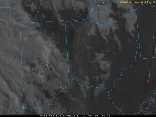
8:00 a.m. images
It appears that we'll have a mostly sunny sky until around Noon to 2:00 p.m. The first line of storms may reach around 2:00 to 4:00 p.m., and they may be the strongest.
Forecast
Toledo 7-day forecast
Last Update: May 11, 2015 6:10 am
Today: Showers and thunderstorms, mainly after 2pm. High near 81. South wind 8 to 15 mph, with gusts as high as 32 mph. Chance of precipitation is 80%. New rainfall amounts between a tenth and quarter of an inch, except higher amounts possible in thunderstorms.
Tonight: Showers and thunderstorms, mainly before 2am, then a slight chance of thunderstorms after 4am. Low around 55. Southwest wind 11 to 17 mph. Chance of precipitation is 80%. New rainfall amounts between a tenth and quarter of an inch, except higher amounts possible in thunderstorms.
Tuesday: A slight chance of showers. Increasing clouds, with a high near 63. Breezy, with a west wind 16 to 23 mph. Chance of precipitation is 20%.
Tuesday Night: Mostly cloudy, with a low around 41. West wind 11 to 18 mph.
Wednesday: Partly sunny, with a high near 59. Northwest wind 9 to 11 mph.
Wednesday Night: Partly cloudy, with a low around 42.
Thursday: Mostly sunny, with a high near 66.
Thursday Night: Mostly cloudy, with a low around 48.
Friday: A chance of showers. Mostly cloudy, with a high near 69. Chance of precipitation is 40%.
Friday Night: A chance of showers. Mostly cloudy, with a low around 55. Chance of precipitation is 40%.
Saturday: Mostly cloudy, with a high near 72.
Saturday Night: Mostly cloudy, with a low around 57.
Sunday: Partly sunny, with a high near 79.
AFD
fxus61 kcle 111142
afdcle
area forecast discussion
national weather service cleveland oh
742 am edt mon may 11 2015
synopsis...
low pressure over minnesota will move into eastern canada by tuesday
dragging a series of cold fronts across the area early tonight
through tuesday. high pressure will move east across the region
wednesday night and thursday then a weak low will move across the
southern part of the lakes along a warm front lifting north.
&&
near term /until 6 pm this evening/...
enough upper ridging should hang on over the area for much of the
day to limit convective coverage. by late in the day...the approach
of a cold front...increased wind shear and improving upper dynamics
should start to improve the chances for more widespread convection
along with the possibility for severe storms. the ongoing forecast
seems to have good handle on situation with ramp up in pops from
west to east starting late in the day.
one more very warm day in store before below normal temps return.
highs should mainly run in the low to mid 80s.
&&
short term /6 pm this evening through thursday night/...
the first in a series of cold fronts should bring a band of strong
to locally severe convection to the area as it sweeps west to east
across the cwa. drier air quickly punches in behind the first front
so most of the shra/tsra should be done with the first front leaving
only widely sct shra left later in the night with the second front.
on tue into tue night....the upper trough works east across lake
erie with another reinforcing cold front. much of the deeper
moisture stays over lake erie so expect sct light shra...especially
for the ne lakeshore. tue should be a fairly windy day with winds of
20 to 25 mph with gusts to 40 mph. temps should rise only a few
degrees on tue due to widespread clouds and the cold advection.
most of the shra should taper off tue night from west to east but a
few could linger in nw pa for a while wed morning. lows tue night
tricky due to uncertainty as to how quickly the cloud cover start to
dissipate.
cold air aloft will act to produce additional daytime cu on wed then
high pressure moves over the area for wed night. highs on wed will
probably only range from around 60 in the sw to only around 50 in
the ne. the cu field should dissipate in the evening and winds
become light. this will set up a good radiational cooling night.
concerned that guidance temps may not be cold enough and that some
frost may occur so will trim guidance temps a little.
high pressure will hang on for thu so a dry day in store. temps
should moderate some but the models show a lot of high
moisture/cirrus moving into the region ahead of the next system in
the plains. the expected cirrus should help to keep lows in the 40s
thu night.
a southerly return flow should set up thu night and lower level
moisture will start to increase. this may allow to some shra to push
into the west part of the cwa by the latter part of the night. will
divide the forecast for thu night to better show an increase in pop
by the end of the night for the west.
&&
long term /friday through sunday/...
by friday the high will have slid off to the east and warmer and
more moist flow will return for the weekend. upper ridge will break
down some as fairly well agreed upon shortwave tops it as it crosses
the lower great lakes at the end of the work week. will continue the
rain chances friday/friday night. have lingered chances into
saturday with some semblance of a surface front in the vicinity.
precip chances return again sunday night as a warm front will be
lifting northward. overall will be returning to above normal
temperatures for the weekend.
&&
aviation /12z monday through friday/...
unsettled weather with a strong storm system moving through the
region. aviation impacts will primarily be from thunderstorms
later this afternoon and evening. light southerly winds today will
increase...with gusts of 20 to 30 knots possible outside of
thunderstorms...especially for tol/fdy/mfd/cle. vfr to start the
day. a cold front will be crossing the area this evening...with an
active prefrontal trough ahead of it. some of these thunderstorms
may produce winds in excess of 45 knots and of course non vfr
conditions. may have some mvfr cigs develop in the wake of the
cold front monday night. southwest gusts on tuesday in excess of
30 knots likely.
outlook...non vfr possible monday night. mvfr ceilings possible
extreme ne oh/nw pa wednesday. non vfr possible again friday.
&&
marine...
light/variable flow to start the morning on the lake will become
southerly today as a warm front lifts north of the lake. showers and
thunderstorms will accompany a cold front for later this afternoon
and evening. some of these storms may be strong with gusty winds.
otherwise winds will pick up on the lake behind the front tonight
and continue from a southwesterly direction on tuesday. winds will
definitely be enough for small craft advisory on tuesday into
wednesday. will top winds out at 25 or 30 knots tuesday...with the
peak in cold air advection occurring. winds slowly subside going
into mid week as high pressure passes overhead. the high shifts east
by friday allowing for southerly flow.
&&
cle watches/warnings/advisories...
oh...none.
pa...none.
marine...none.
&&
$$
synopsis...adams
near term...adams
short term...adams
long term...oudeman
aviation...oudeman
marine...oudeman
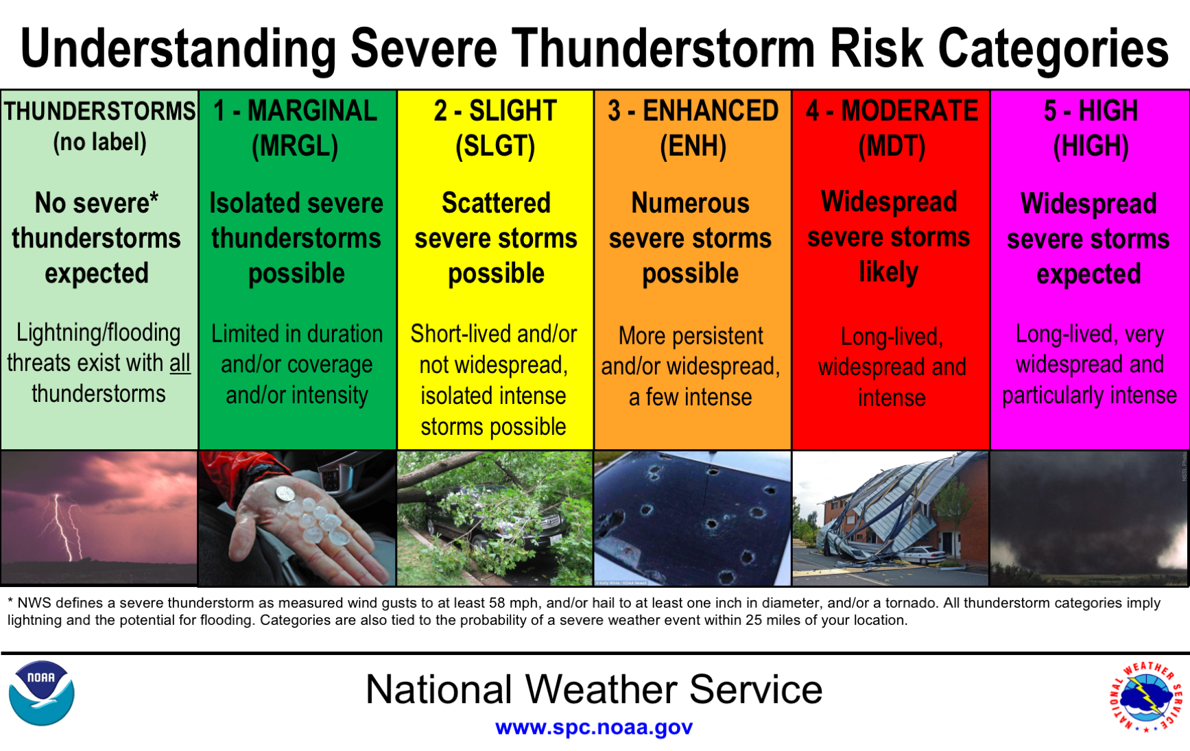
http://www.spc.noaa.gov/misc/SPC_5-tier_Convective_Outlook_Info_files/understanding_categories.png
Mid-morning HWO
hazardous weather outlook
national weather service cleveland oh
922 am edt mon may 11 2015
for lake erie...north central
ohio...northeast ohio...northwest ohio and northwest pennsylvania.
.day one...today and tonight.
there is a slight risk for severe thunderstorms today and early
tonight. the primary threat will be strong damaging winds and
large hail. an isolated tornado is also possible.
.days two through seven...tuesday through sunday.
no hazardous weather is expected at this time.
.spotter information statement...
spotter activation is not expected at this time.
N. IN. AFD
fxus63 kiwx 111047
afdiwx
area forecast discussion
national weather service northern indiana
647 am edt mon may 11 2015
synopsis...
issued at 413 am edt mon may 11 2015
showers and thunderstorms are expected to move across the area
today...especially between mid morning and early evening. severe
weather is possible this afternoon into early evening...especially
over east and northeast indiana...northwest ohio and southeast
lower michigan. high temperatures will range from the lower 80s
east to lower and middle 70s west. rain chances will decrease
tonight as it becomes cooler and less humid behind a cold front.
lows will drop into the 50s.
&&
short term...(today and tonight)
issued at 413 am edt mon may 11 2015
severe weather and locally heavy rain threat today remains the
concern in the short term period. water vapor this morning shows
upper low in the dakotas with sfc low over eastern sd. occluded
front stretches to triple point in ia with quasi stationary
boundary east through northern indiana and a trailing cold front
from ia into tx. regional radar mosaic showed a large area of
showers and thunderstorms with heavy rain ahead of the cold front
lifting northeast through southeast mo into southern il early this
morning.
quasi stationary boundary expected to lift into southern mi this
morning as south southwest low level flow increases. this puts our
area in the warm sector today though existing cloud cover remains
problematic and conditional for severe weather chances this
afternoon. 0-6km bulk shear increases to around 40 knots by
afternoon as mid level height falls spread east. short wave
responsible for mo convection this morning expected to lift
northeast across our region while associated pcpn to move into
southwest area this morning. most guidance in agreement on bulk
of this pcpn moving northeast through about the western half of
our cwa this morning which keeps severe weather threat there quite
low with lack of any heating and destabilization. pwat values
close to 1.75 inches though supports locally heavy rainfall today
which could create some localized flooding issues in areas that
have seen rain past few days.
the question then for this afternoon is whether we can see any
breaks in cloud cover over the east to allow some heating and
destabilization for stronger thunderstorm development ahead of
main cold front. nam12 soundings most aggressive with mucapes to
between 1 and 2k j/kg along with the deep layer shear of 40 knots.
this more than sufficient for severe storms but
again...conditional on the cloud cover and heating to generate the
increased cape values. damaging winds and hail would be primary
hazards if severe weather does develop. however...there is some
low level directional shear noted in the soundings over our
northeast which coupled with the strong deep layer shear could aid
in a few stronger rotating storms and possibility of an isolated
tornado...assuming instability materializes. spc has included this
region in a slight risk today along with a 5 percent prob for
tornadoes.
bulk of convection should be into nw ohio by early evening and
quickly exiting our local area around 00z/12. some hints at a few
lingering showers with main front and cold air advection in the
evening so have left a small chance for showers through midnight.
drier air to clear things out late before wrap around clouds begin
to invade the north toward sunrise.
&&
long term...(tuesday through sunday)
issued at 413 am edt mon may 11 2015
upper trough axis will work through the great lakes region on
tuesday. steepening low level lapse rates under this cold pocket
aloft should provide good momentum transfer for 30-35 mph
gusts...with potential for just enough wrap around moisture to spark
a few showers/sprinkles across far northeastern zones by late
morning/afternoon. dry/much cooler with a bkn/ovc stratocu deck
otherwise tuesday.
building heights in wake of the upper trough will allow high
pressure to build in for the middle of the week. temps will
gradually rebound but remain below normal for the most part through
thursday. shower/storm chances and milder temps then return friday
into next weekend as moisture increases on the backside of high
pressure and several shortwaves eject through in developing
southwest flow.
&&
aviation...(for the 12z tafs through 12z tuesday morning)
issued at 639 am edt mon may 11 2015
regional radar mosaic shows large area of showers and embedded
thunderstorms lifting northeast through il this morning. this area
will slide east this morning with rain moving into ksbn around
15z. rain shield continues to move east while main short wave
over eastern arkansas this morning races into indiana by
afternoon. this will set the stage for stronger thunderstorms near
kfwa provided atmosphere can sufficiently destabilize. potential wind
gusts to 60 knots possible if stronger storms develop. partial
clearing expected this evening in wake of cold front.
&&
iwx watches/warnings/advisories...
in...none.
mi...none.
oh...none.
lm...dense fog advisory until 9 am edt this morning for lmz043-046.
&&
$$
synopsis...lashley
short term...lashley
long term...steinwedel
aviation...lashley
visit us at www.weather.gov/iwx (all lower case)
follow us on facebook...twitter...and youtube at:
www.facebook.com/nwsnorthernindiana
www.twitter.com/nwsiwx
www.youtube.com/nwsnorthernindiana
Det/Pon AFD
link
fxus63 kdtx 111517
afddtx
area forecast discussion
national weather service detroit/pontiac mi
1117 am edt mon may 11 2015
update...
difficult forecast to get a handle on the evolution of this
afternoons convection. basic synoptic setup referenced in early
discussions remain the same. current showers and storms over the
western half of indiana and lake mi were several hours ahead of
schedule based off of 00z and 06z hi res runs. this band of
showers and storms was spreading cloud cover across most of
indiana and western lower which could compromise the atmosphere
for the afternoon. despite the slightly eastward advance of the
rain shield...timing of 3 pm to 9 pm for the best coverage and
intensity for the southeast mi thunderstorms is still on target.
several arms of moisture/theta-e advection were also kicking off
showers. the first extended across saginaw bay into the tip of the
thumb...while the other moisture surge triggered showers in sc
lower mi and nw oh. this surge will work through the cwa early
this afternoon.
that leaves the question of how much instability do we achieve and
where will it be maximized. a temp of 80 and dew point of 62 gets
a mlcape around 1000 j/kg from 12z dtx and nam/hi res forecast
soundings. that is possible in the southeast 1/4 to 1/2 of the
cwa with a few peaks of sunshine during the afternoon. something
like an ozw to sandusky line and south would seem to be the threat
area. 12z dtx sounding should have some air mass replacement...and
expect to send up an 18z sounding to sample that. wind fields will
be the most notable as the 50-60kt 500 mb jet and 35-50kt 850 mb
jet move into the southern great lakes.
with enough instability...could be a few shallow supercells that
develop initially before they transition into small bowing
segments. with the increasing low level wind enough 0-1km shear
and helicity that if the storms develop...the storms could rotate.
lcl is forecast to be rather robust...but given the lack of full
sunshine...the mixed layer could be lower. will continue to
highlight wind as the greatest threat...with just an isolated
threat from hail or a tornado. any flood threat should be
localized as the storms should have a decent forward propagation
component to them.
&&
aviation...issued 646 am edt mon may 11 2015
ifr/lifr cigs/vsbys will steadily improve early in the forecast as
low level mixing increases and frontal boundary shifts north during
the morning. by mid/late morning...vfr conditions should become the
rule...with the transition occurring from south to north. attention
then turns to convective potential late today as a cold front works
into the area. timeframe still looks to be roughly 18z-20z through
00z-02z or so...with ifr/mvfr conditions with some of this activity.
sct-bkn lower vfr conditions are then expected tonight in the wake
of this activity with steady 10-12kt sw flow persisting.
for dtw...lower cigs/vsbys will lift in the 12z-14z time frame as
southerly flow gradually mixes to the surface. after a relatively
quiet mid morning to early afternoon...expect shras/tsras to spread
back into the terminal by 20z or so...and persist at times through
01z as a cold front pivots through the area. ifr/mvfr conditions
will be possible with some of this activity.
//dtw threshold probabilities...
* medium in ceilings aob 5kft 18z-04z this afternoon and
evening.
- medium in thunderstorm occurrence after 20z this afternoon.
Noon Time weather
From the 11:17 a.m. Det/Pon AFD
that leaves the question of how much instability do we achieve and where will it be maximized. a temp of 80 and dew point of 62 gets a mlcape around 1000 j/kg from 12z dtx and nam/hi res forecast soundings. that is possible in the southeast 1/4 to 1/2 of the cwa with a few peaks of sunshine during the afternoon. something like an ozw to sandusky line and south would seem to be the threat area.
TOL:
May 11, 2015 11:52 am
Weather : Mostly Cloudy
Temperature : 75 F
Humidity : 64%
Wind Speed : SW 12 mph - Gust 20 mph
Barometer : 29.97 in
Dewpoint: 62 F
Visibility : 10.00 statute miles
Seems mostly sunny or at least partly cloudy to me. Temps not as warm at Noon as originally thought, though. Although Toledo Executive is warmer.
(formerly Metcalf Airport)
May 11, 2015 11:53 am
Weather : Fair
Temperature : 79 F
Humidity : 52%
Wind Speed : SW 13 mph
Barometer : 29.97 in
Dewpoint: 60 F
Visibility : 10.00 statute miles
(near Lambertville)
May 11, 2015 11:54 am
Weather : Partly Cloudy
Temperature : 77 F
Humidity : 61%
Wind Speed : SW 8 mph
Barometer : 29.96 in
Dewpoint: 63 F
Visibility : 10.00 statute miles
Wundermap at 12:08 p.m. shows Toledo area temps mainly in the 75 to 78 degree range.
Temps, however, were in the low to mid 80s east and south of Toledo. Port Clinton - Sandusky - Findlay were in the 80s at 12:10 p.m. Basically, east of I-75 and south of the lake shore were in the low to mid 80s around Noon. Maybe the worst storms will occur east and south of Toledo.
MD

md 0606 concerning severe potential...tornado watch likely for portions of ohio...indiana...southern lower michigan...far northern kentucky
mesoscale discussion 0606
nws storm prediction center norman ok
1148 am cdt mon may 11 2015
areas affected...portions of ohio...indiana...southern lower
michigan...far northern kentucky
concerning...severe potential...tornado watch likely
valid 111648z - 111915z
probability of watch issuance...80 percent
summary...portions of the lower great lakes and ohio valley region
are being monitored for an increasing risk of severe thunderstorms
including the potential for a few tornadoes. the issuance of a
tornado watch is likely.
discussion...a cluster of convection intensifying across southern
indiana can be traced back to a long-lived convective circulation
emanating from southern-plains diurnally enhanced thunderstorms from
yesterday afternoon. this activity continues cycling -- having
weakened in response to nocturnal cooling -- and should continue to
re-intensify as it tracks newd across parts of indiana and wrn ohio
to srn lower mi. this zone aligns with vis-imagery-implied...
diurnally enhanced baroclinicity owing to differential heating
across the remnant cloud shield from more widespread decayed
convection. as baroclinic circulations intensify through the
afternoon...and the air mass becomes increasingly unstable amidst
lower 60s sfc dewpoints...other convection will increase in coverage
and intensity within a warm sector s of a synoptic warm front
advancing nwd across srn lower mi.
mlcape within the warm sector air is projected to peak around
1000-1500 j/kg...while 30-50 kt of effective bulk shear supports
small...fast moving bowing segments capable of dmgg wind gusts. the
ind vwp samples 45-55 kt of flow in the 1-3-km-agl layer...enhancing
the risk for dmgg wind gusts by convective momentum transport. while
directional shear/hodograph curvature will be limited in general --
except invof the mi warm front -- the magnitude of low-level shear
will be sufficient for a tornado risk with any sustained supercell
storms / lewp inflections. such risk will be greatest near backed
sfc flow invof the warm front.
..cohen/corfidi.. 05/11/2015
...please see www.spc.noaa.gov for graphic product...
attn...wfo...cle...iln...dtx...lmk...iwx...grr...ind...
lat...lon 39238659 41358562 43638432 43418249 41828232 39908295
38618453 38468601 39238659
Tornado Watch
tornado watch outline update for wt 164
nws storm prediction center norman ok
110 pm edt mon may 11 2015
tornado watch 164 is in effect until 800 pm edt for the
following locations
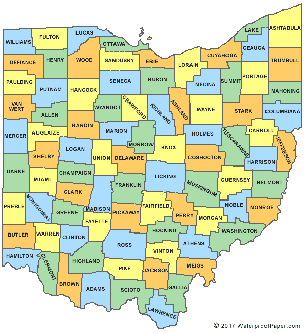
ohc003-005-011-017-021-023-025-027-033-037-039-041-043-045-047-
049-051-057-061-063-065-069-077-083-089-091-093-095-097-101-107-
109-113-117-123-125-129-135-137-139-143-147-149-159-161-165-171-
173-175-120000-
/o.new.kwns.to.a.0164.150511t1710z-150512t0000z/
oh
. ohio counties included are
allen ashland auglaize
butler champaign clark
clermont clinton crawford
darke defiance delaware
erie fairfield fayette
franklin fulton greene
hamilton hancock hardin
henry huron knox
licking logan lorain
lucas madison marion
mercer miami montgomery
morrow ottawa paulding
pickaway preble putnam
richland sandusky seneca
shelby union van wert
warren williams wood
wyandot
$$
URGENT - IMMEDIATE BROADCAST REQUESTED
TORNADO WATCH NUMBER 164
NWS STORM PREDICTION CENTER NORMAN OK
110 PM EDT MON MAY 11 2015
THE NWS STORM PREDICTION CENTER HAS ISSUED A
- TORNADO WATCH FOR PORTIONS OF
CENTRAL AND EASTERN INDIANA
NORTHERN KENTUCKY
SOUTHEASTERN MICHIGAN
WESTERN ANDN NORTHERN OHIO
LAKE ERIE
LAKE HURON
- EFFECTIVE THIS MONDAY AFTERNOON AND EVENING FROM 110 PM UNTIL
800 PM EDT.
- PRIMARY THREATS INCLUDE...
A COUPLE TORNADOES POSSIBLE
WIDESPREAD DAMAGING WINDS LIKELY WITH ISOLATED SIGNIFICANT GUSTS
TO 75 MPH POSSIBLE
ISOLATED LARGE HAIL EVENTS TO 1.5 INCHES IN DIAMETER POSSIBLE
SUMMARY...THUNDERSTORMS...INCLUDING POSSIBLE SUPERCELLS AND STORMS
WITH BOWING STRUCTURES...EXPECTED TO MOVE/DEVELOP FAIRLY RAPIDLY
NORTHEAST ACROSS WATCH AREA THROUGH EARLY EVENING...WITH A RISK FOR
DAMAGING WIND...A COUPLE TORNADOES...AND SEVERE HAIL.
THE TORNADO WATCH AREA IS APPROXIMATELY ALONG AND 120 STATUTE
MILES NORTH AND SOUTH OF A LINE FROM 15 MILES NORTH NORTHWEST OF
INDIANAPOLIS INDIANA TO 55 MILES SOUTHEAST OF MOUNT CLEMENS
MICHIGAN. FOR A COMPLETE DEPICTION OF THE WATCH SEE THE
ASSOCIATED WATCH OUTLINE UPDATE (WOUS64 KWNS WOU4).
PRECAUTIONARY/PREPAREDNESS ACTIONS...
REMEMBER...A TORNADO WATCH MEANS CONDITIONS ARE FAVORABLE FOR
TORNADOES AND SEVERE THUNDERSTORMS IN AND CLOSE TO THE WATCH
AREA. PERSONS IN THESE AREAS SHOULD BE ON THE LOOKOUT FOR
THREATENING WEATHER CONDITIONS AND LISTEN FOR LATER STATEMENTS
AND POSSIBLE WARNINGS.
Early PM CO
Early PM Notes
Guesses this morning have occurred, although nothing was a stretch.
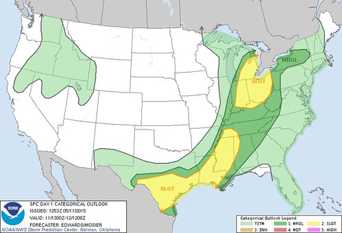
- The SPC upgraded our area to an Enhanced Risk.
- The SPC issued a mesoscale discussion between Noon and 3:00 p.m. (issued at 12:48 p.m. EDT).
- The SPC issued a watch between 1:00 p.m. and 3:00 p.m. (tornado watch issued at 1:10 p.m. EDT).
Warnings and Watches
Tornado Warning
Statement as of 1:34 PM EDT on May 11, 2015
... A Tornado Warning remains in effect for central Allen County until
145 PM EDT...
At 133 PM EDT... a severe thunderstorm capable of producing a tornado
was located 5 miles southeast of New Haven... and moving northeast at
35 mph.
Hazard... tornado.
Source... radar indicated rotation.
Impact... Mobile homes will be damaged or destroyed. Damage to
roofs... windows and vehicles will occur. Flying debris will
be deadly to people and animals. Tree damage is likely.
Locations impacted include...
New Haven... Tillman... Zulu and Townley.
Precautionary/preparedness actions...
Take cover now. Move to an interior room on the lowest floor of a
sturdy building. Avoid windows. If in a Mobile home... a vehicle or
outdoors... move to the closest substantial shelter and protect
yourself from flying debris.
Lat... Lon 4096 8497 4102 8508 4118 8497 4104 8480
time... Mot... loc 1734z 226deg 32kt 4100 8497
Tornado... radar indicated
hail... 0.00in
That one will miss Van Wert County.
Anytime a threat of severe weather exist within our region, my bet is on Van Wert County getting pounded.
Paulding County in Ohio will probably warned soon.
Severe Thunderstorm Warning
Statement as of 1:41 PM EDT on May 11, 2015
The National Weather Service in northern Indiana has issued a
- Severe Thunderstorm Warning for...
eastern Allen County in Northeast Indiana...
southeastern De Kalb County in Northeast Indiana...
Defiance County in Northwest Ohio...
northwestern Paulding County in west central Ohio...
- until 215 PM EDT
- at 138 PM EDT... a severe thunderstorm was located 5 miles southwest
of Woodburn... and moving northeast at 55 mph.
Hazard... quarter size hail and 60 mph wind gusts.
Source... radar indicated.
Impact... hail damage to vehicles is expected. Expect wind damage to
roofs... siding and trees.
- The severe thunderstorm will be near...
Antwerp around 150 PM EDT.
Hicksville around 155 PM EDT.
Other locations in the warning include Georgetown... Mark Center...
Farmer and Ney.
This includes Interstate 469 between mile markers 23 and 25.
Precautionary/preparedness actions...
For your protection move to an interior room on the lowest floor of a
building.
Lat... Lon 4105 8471 4100 8491 4113 8502 4143 8482
4142 8427
time... Mot... loc 1741z 215deg 47kt 4111 8489
Hail... 1.00in
wind... 60mph
Jball
If the cell holds, parts of Williams and maybe Fulton counties will be warned. We'll see if the storm is fizzling out, or if it's capable of maintaining, even cycling back upward. If no warnings for Williams and/or Fulton counties, then it's a short-lived cell, and not a super-cell.
http://www.digital-topo-maps.com/county-map/ohio-county-map.gif
The National Weather Service in northern Indiana has issued a
- Severe Thunderstorm Warning for...
Defiance County in Northwest Ohio...
Fulton County in Northwest Ohio...
northwestern Henry County in Northwest Ohio...
southeastern Williams County in Northwest Ohio...
- until 300 PM EDT
- at 209 PM EDT... a severe thunderstorm was located 10 miles south of
Bryan... and moving northeast at 45 mph.
Hazard... half dollar size hail and 70 mph wind gusts.
Source... radar indicated.
Impact... hail damage to vehicles is expected. Expect considerable
tree damage. Wind damage is also likely to Mobile homes...
roofs and outbuildings.
- The severe thunderstorm will be near...
Bryan around 220 PM EDT.
Stryker around 225 PM EDT.
Archbold around 235 PM EDT.
Wauseon around 245 PM EDT.
Delta around 255 PM EDT.
Other locations in the warning include Evansport... Ridgeville
Corners... Burlington... Elmira... Pettisville... Tedrow... Ottokee...
Oakshade... Winameg and Lyons.
This includes Interstate 80 90 in Ohio between mile markers 23 and
48.
Precautionary/preparedness actions...
Prepare immediately for large hail and damaging winds. People outside
should move to a shelter... inside a strong building and away from
windows.
Lat... Lon 4156 8387 4125 8445 4125 8454 4139 8466
4171 8423 4171 8387
time... Mot... loc 1811z 231deg 39kt 4134 8455
Hail... 1.25in
wind... 70mph
this cell may hit Toledo.
Severe Thunderstorm Warning
Statement as of 2:22 PM EDT on May 11, 2015
The National Weather Service in northern Indiana has issued a
- Severe Thunderstorm Warning for...
northeastern Adams County in Northeast Indiana...
southeastern Defiance County in Northwest Ohio...
south central Henry County in Northwest Ohio...
southeastern Paulding County in west central Ohio...
northwestern Putnam County in west central Ohio...
Van Wert County in west central Ohio...
- until 300 PM EDT
- at 219 PM EDT... a severe thunderstorm was located 6 miles east of
Monroe... and moving northeast at 55 mph.
Hazard... quarter size hail and 60 mph wind gusts.
Source... radar indicated.
Impact... hail damage to vehicles is expected. Expect wind damage to
roofs... siding and trees.
- Locations impacted include...
Van Wert... Convoy... Continental... Holgate... Abanaka... Glenmore...
dull... Middlebury... Cavett... Scott... Haviland... Wetzel... Grover
Hill... Broughton... Roselms... Mandale... Melrose... Charloe...
Cloverdale and Oakwood.
Precautionary/preparedness actions...
For your protection move to an interior room on the lowest floor of a
building.
Lat... Lon 4072 8472 4072 8479 4067 8481 4080 8496
4137 8418 4118 8396
time... Mot... loc 1822z 228deg 48kt 4080 8479
Hail... 1.00in
wind... 60mph
"The one moving into JR's favorite county should be warned too."
If I could have, that's where I would have setup shop today. Van Wert is a magnet.
But it looks like multiple areas will see storms today. Activity has definitely increased.
The Paulding County storm may scrape western Lucas County.
The Van Wert County storm may move through southern Lucas and northern Wood counties.
special weather statement
national weather service cleveland oh
229 pm edt mon may 11 2015
ohz003-006-017-027-111930-
hancock-lucas-wood-wyandot-
229 pm edt mon may 11 2015
...special weather statement for hancock...lucas...northwestern
wyandot and wood counties until 330 pm edt...
at 224 pm edt...national weather service doppler radar was tracking
strong thunderstorms along a line extending from 29 miles west of
swanton to 43 miles southwest of deshler...moving northeast at 20
mph. the storms should move into the area by 330 pm this afternoon.
these storms will affect the region with gusty winds and hail along
with cloud to ground lightning. be alert for possible warnings.
Severe Thunderstorm Warning
Statement as of 2:35 PM EDT on May 11, 2015
... A Severe Thunderstorm Warning remains in effect for southeastern
Defiance... southeastern Paulding... Van Wert... south central Henry and
northwestern Putnam counties until 300 PM EDT...
At 233 PM EDT... a severe thunderstorm was located near Convoy... and
moving northeast at 55 mph.
Hazard... quarter size hail and 60 mph wind gusts.
Source... radar indicated.
Impact... hail damage to vehicles is expected. Expect wind damage to
roofs... siding and trees.
Locations impacted include...
Continental... Holgate... Cavett... Scott... Haviland... Wetzel... Grover
Hill... Broughton... Roselms... Mandale... Melrose... Cloverdale...
Charloe... Oakwood... DuPont... Wisterman... Arthur... North Creek...
Kieferville and Ayersville.
Precautionary/preparedness actions...
For your protection move to an interior room on the lowest floor of a
building.
Lat... Lon 4072 8472 4073 8480 4092 8480 4137 8418
4118 8396
time... Mot... loc 1835z 227deg 48kt 4092 8463
Hail... 1.00in
wind... 60mph
Lucas County Tstrm
ohc095-173-112015-
/o.new.kcle.sv.w.0006.150511t1934z-150511t2015z/
bulletin - immediate broadcast requested
severe thunderstorm warning
national weather service cleveland oh
334 pm edt mon may 11 2015
the national weather service in cleveland has issued a
- severe thunderstorm warning for...
lucas county in northwest ohio...
northwestern wood county in northwest ohio...
- until 415 pm edt
- at 333 pm edt...a severe thunderstorm was located near swanton...
and moving northeast at 35 mph.
hazard...60 mph wind gusts.
source...radar indicated.
impact...expect damage to roofs...siding and trees.
- locations impacted include...
sylvania...toledo...perrysburg...holland...rossford...oregon...
maumee...berkey...ottawa hills and harbor view.
precautionary/preparedness actions...
for your protection move to an interior room on the lowest floor of a
building.
&&
lat...lon 4151 8389 4172 8389 4172 8388 4173 8375
4174 8372 4174 8345 4166 8341 4139 8388
4150 8390
time...mot...loc 1934z 214deg 30kt 4161 8387
hail...
Another MD

md 0618 concerning tornado watch 164... for portions of central/northern/western ohio...southeastern lower michigan...eastern indiana
mesoscale discussion 0618
nws storm prediction center norman ok
0339 pm cdt mon may 11 2015
areas affected...portions of central/northern/western
ohio...southeastern lower michigan...eastern indiana
concerning...tornado watch 164...
valid 112039z - 112145z
the severe weather threat for tornado watch 164 continues.
summary...the risk for damaging wind gusts continues across ww 164.
discussion...the overall svr risk continues transitioning toward
dmgg wind gusts. multicell clusters are developing newd across the
area...with the leading edge of this activity spreading into the
columbus metropolitan area nwd to detroit. similar activity is
spreading newd across wrn ohio...and all of this convection will
pose a risk for locally dmgg wind gusts where antecedent convective
processing has not been substantial. the wilmington ohio vwp samples
35-45 kt of flow through the cloud layer supporting fast-moving
convective clusters with convective momentum transport enhancing the
dmgg-wind potential where low-level lapse rates remain steep. areas
farther w into cntrl indiana are still e of the synoptic wind
shift...and some convective re-development cannot be ruled out
there.
..cohen.. 05/11/2015
...please see www.spc.noaa.gov for graphic product...
attn...wfo...cle...iln...dtx...iwx...grr...ind...
lat...lon 39048497 39248558 40318536 43498358 43838332 43548234
42018294 41648209 40158243 39638372 39048497
Storm Report
It seems that the immediate Toledo area did okay.
I'm guessing that our tornado watch will be canceled soon. A little bit of rain exists in Fulton and Henry counties, but behind that, the radar looks clear.
Some scattered power outages exist in the Toledo area, according to the FirstEnergy outage map.
I don't know if this Blade story was storm-related:
More than 5,600 Toledo Edison customers are without power because of a malfunctioning transmission line, officials said.Wood County has the greatest number of customers without power - 3,525. Henry County has 1,440 customers without power; 654 customers in Lucas County are affected, and 64 in Fulton County.
It was also not known when power would be restored.
Radar estimates show rainfall totals over the Toledo area only ranging from 0.10 to 0.60 inches with some pockets receiving a little more. No flooding issues.
A little storm damage occurred west of us, including in Van Wert County.
0207 pm     tstm wnd gst     1 se mark center        41.28n  84.62w
05/11/2015  e60 mph          defiance           oh   trained spotter

0207 pm     hail             1 se mark center        41.28n  84.62w
05/11/2015  e1.00 inch       defiance           oh   trained spotter

0224 pm     tstm wnd dmg     evansport               41.43n  84.40w
05/11/2015                   defiance           oh   fire dept/rescue

            trees and powerlines down near evansport.

0224 pm     tstm wnd dmg     wren                    40.80n  84.78w
05/11/2015                   van wert           oh   emergency mngr

            large tree down. church under construction had the
            north wall bowed outward.

0235 pm     tstm wnd dmg     4 n archbold            41.58n  84.31w
05/11/2015                   fulton             oh   emergency mngr

            two large trees and several branches down. semi blown
            over on toll road near milepost 29

0350 pm     tstm wnd dmg     jonestown               40.77n  84.51w
05/11/2015                   van wert           oh   emergency mngr

            roof torn off of a barn and a large tree down.

0350 pm     tstm wnd gst     elgin                   40.74n  84.48w
05/11/2015  m51 mph          van wert           oh   emergency mngr
end
From JR's : articles
7690 words - 49718 chars
- 42 min read
created on
updated on
- #
source
- versions
Related articles
Severe weather threat for Sun, Nov 17, 2013 - Nov 18, 2013
Nov 17, 2013 Toledo area weather notes - Mar 03, 2014
Posts related to Nov 17, 2013 severe weather - Nov 21, 2013
Toledo area weather for early December 2013 - Dec 05, 2013
Mon, Dec 9, 2013 winter storm forecast for Sat, Dec 14 - Dec 14, 2013
more >>