Toledo Weather Wed, May 20, 2015
TOL:
May 20, 2015 4:52 am
Weather : Fair
Temperature : 38 F
Humidity : 76%
Wind Speed : N 7 mph
Barometer : 30.17 in
Dewpoint: 31 F
Visibility : 10.00 statute miles
Wind Chill : 33 F
(formerly Metcalf Airport)
May 20, 2015 4:53 am
Weather : Fair
Temperature : 41 F
Humidity : 67%
Wind Speed : N 8 mph
Barometer : 30.18 in
Dewpoint: 31 F
Visibility : 10.00 statute miles
Wind Chill : 36 F
(near Lambertville)
May 20, 2015 5:35 am
Weather : Partly Cloudy
Temperature : 39 F
Humidity : 75%
Wind Speed : N 8 mph
Barometer : 30.18 in
Dewpoint: 32 F
Visibility : 10.00 statute miles
Wind Chill : 33 F
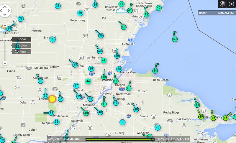
5:46 a.m. Toledo Area Forecast Summaries
(using forecast.io data)
Now: Partly Cloudy 40 F - N at 6 mph
At 5:47 a.m. West Toledo Wundermap stations LTWS and WTWS reported 39 degrees.
Toledo 7-day forecast
Last Update: May 20, 2015 4:03 am
Today: Partly sunny, with a high near 58. North wind 6 to 11 mph becoming northeast in the afternoon.
Tonight: A slight chance of showers before 1am. Mostly cloudy, with a low around 39. Calm wind becoming southwest around 6 mph after midnight. Chance of precipitation is 20%.
Thursday: Mostly sunny, with a high near 66. West wind 7 to 13 mph.
Thursday Night: Partly cloudy, with a low around 47. Southwest wind 7 to 11 mph.
Friday: Sunny, with a high near 66. North wind 9 to 14 mph.
Friday Night: Mostly clear, with a low around 45.
Saturday: Mostly sunny, with a high near 72.
Saturday Night: Mostly cloudy, with a low around 53.
Sunday: A chance of showers and thunderstorms. Mostly cloudy, with a high near 72. Chance of precipitation is 30%.
Sunday Night: A chance of showers and thunderstorms. Cloudy, with a low around 60. Chance of precipitation is 40%.
Memorial Day: A chance of showers and thunderstorms. Cloudy, with a high near 75. Chance of precipitation is 40%.
Monday Night: A chance of showers and thunderstorms. Mostly cloudy, with a low around 63. Chance of precipitation is 30%.
Tuesday: A chance of showers and thunderstorms. Mostly cloudy, with a high near 76. Chance of precipitation is 40%.
fxus61 kcle 200752
afdcle
area forecast discussion
national weather service cleveland oh
352 am edt wed may 20 2015
synopsis...
high pressure from the northern plains will move slowly east across
the great lakes through the end of the week. low pressure from
oklahoma will track across the tennessee valley today and off the
southeast coast on friday. a weak cold front will drop across the
eastern great lakes early friday.
&&
near term /until 6 pm this evening/...
the stratocumulus is exiting slowly east at 15-20 mph. high clouds
are spreading in from the west ahead of the upper low ejecting from
the southwestern states. there may not be much opportunity to see
much sunshine before the high clouds thicken and begin to lower from
west to east. thin spots in the high clouds may linger across
extreme northeast ohio and northwest pa into the afternoon. a
sprinkle may sneak into the i-75 corridor toward evening. highs
mostly in the upper 50s/around 60 except cooler near lake erie
with the north wind...lower and mid 50s.
&&
short term /6 pm this evening through saturday night/...
a sprinkle/light shower could clip the southwest quarter of the
forecast area from around bowling green to bucyrus and mount
vernon early tonight but nothing significant expected as the
upper low shears as it moves east. lows generally from the upper
30s to the lower/mid 40s except across extreme northeast oh and
northwest pa. a touch of frost is possible across eastern erie and
crawford counties pa.
not sure how many clouds will linger on thursday. i suspect that
the majority of the mid/high clouds will shift east and there may
be some cumulus/stratocumulus but probably not enough to keep it
cloudy. partly cloudy is probably the best forecast. highs
generally in the lower/mid 60s.
a weak cold front is progged to drop across the area early on
friday. not much jet support although we remain in the trough aloft.
dew points will be in the 30s and a lot of dry air to overcome.
the air aloft will likely not be cold enough for pure lake
effect. there is a relatively small window of opportunity with
upward motion. cannot rule out a shower/sprinkle in the snowbelt
but will keep the forecast dry for now with a pop around 10
percent. dry otherwise into the weekend. there is a small chance
for frost in the colder spots of extreme northeast oh and
northwest pa late fri night/early sat morning. after a chilly
start...highs on saturday recovering back toward normal.
&&
long term /sunday through tuesday/...
upper level ridge amplifies dramatically across the eastern united
states sunday through monday. this translates to a large area of
high pressure that will move fairly quickly east to the east coast
in the same time frame. as high moves east...conveyor belt of
moisture will stream north up through the central united states from
the gulf of mexico and head right for the forecast area by sunday
night into monday. a series of positive vorticity maximums will
rotate northeast across the area on the western periphery of the
upper level ridge. this will bring another round of showers and
thunderstorms to the region through tuesday.
other factor will be the warm air advection following the eastward
moving high pressure. the high will bring warmer air back to the
region from the south. the threat for showers and cloud cover will
likely keep temperatures from getting too warm in the warm sector if
clouds remain the rule through the period
&&
aviation /06z wednesday through sunday/...
clouds continue to move east across the forecast area this
morning. some clearing moved into the western portions. expecting
clearing to gradually work east through the morning hours. but
high clouds in advance of next system will push in as well.
expecting some mid clouds lowering to around 5000 feet with some
sprinkles or showers later this evening at fdy and mfd.
otherwise...rest of the area should be dry. winds going light and
variable tonight after remaining north to northwest today.
outlook...non vfr possible sunday afternoon and night in showers
and thunderstorms.
&&
marine...
lake erie should be relatively quiet through thursday. expecting
an increase in the wind flow by thursday night forcing waves to
build to 3 to 4 feet over the eastern half of the lake. may need
small craft advisory thursday night but it should be brief as
waves subside rather quickly by friday. otherwise...lake remains
rather quiet going into the weekend.
&&
cle watches/warnings/advisories...
oh...none.
pa...none.
marine...none.
&&
$$
synopsis...kosarik
near term...kosarik
short term...kosarik
long term...lombardy
aviation...lombardy
marine...lombardy
TOL:
May 20, 2015 5:52 am
Weather : Fair
Temperature : 38 F
Humidity : 76%
Wind Speed : N 5 mph
Barometer : 30.18 in
Dewpoint: 31 F
Visibility : 10.00 statute miles
Wind Chill : 34 F
TOL:
May 20, 2015 6:52 am
Weather : Fair
Temperature : 37 F
Humidity : 76%
Wind Speed : N 6 mph
Barometer : 30.19 in
Dewpoint: 30 F
Visibility : 10.00 statute miles
Wind Chill : 32 F
(formerly Metcalf Airport)
May 20, 2015 6:53 am
Weather : Fair
Temperature : 41 F
Humidity : 62%
Wind Speed : N 9 mph
Barometer : 30.20 in
Dewpoint: 29 F
Visibility : 10.00 statute miles
Wind Chill : 35 F
(near Lambertville)
May 20, 2015 6:54 am
Weather : Partly Cloudy
Temperature : 37 F
Humidity : 81%
Wind Speed : N 3 mph
Barometer : 30.20 in
Dewpoint: 32 F
Visibility : 10.00 statute miles
Wind Chill : 35 F
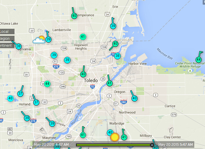
7:24 a.m. Toledo Area Forecast Summaries
(using forecast.io data)
Now: Clear 40 F - NNW at 6 mph
7:25 a.m. WTWS and LTWS still reported 39 degrees.
TOL:
May 20, 2015 12:52 pm
Weather : Fair
Temperature : 53 F
Humidity : 47%
Wind Speed : ENE 10 mph
Barometer : 30.19 in
Dewpoint: 33 F
Visibility : 10.00 statute miles
(formerly Metcalf Airport)
May 20, 2015 12:53 pm
Weather : Fair
Temperature : 51 F
Humidity : 54%
Wind Speed : ENE 9 mph
Barometer : 30.20 in
Dewpoint: 35 F
Visibility : 10.00 statute miles
(near Lambertville)
May 20, 2015 1:35 pm
Weather : Fair
Temperature : 54 F
Humidity : 51%
Wind Speed : SSE 3 mph
Barometer : 30.19 in
Dewpoint: 36 F
Visibility : 10.00 statute miles
1:51 p.m. Toledo Area Forecast Summaries
(using forecast.io data)
Now: Clear 53 F - ENE at 5 mph
From JR's : articles
1448 words - 8326 chars
- 8 min read
created on
updated on
- #
source
- versions
Related articles
Severe weather threat for Sun, Nov 17, 2013 - Nov 18, 2013
Nov 17, 2013 Toledo area weather notes - Mar 03, 2014
Posts related to Nov 17, 2013 severe weather - Nov 21, 2013
Toledo area weather for early December 2013 - Dec 05, 2013
Mon, Dec 9, 2013 winter storm forecast for Sat, Dec 14 - Dec 14, 2013
more >>