Toledo Weather - Sat, May 30, 2015
hazardous weather outlook
national weather service cleveland oh
636 am edt sat may 30 2015
ohz003-006>009-017>019-311045-
lucas-wood-ottawa-sandusky-erie oh-hancock-seneca-huron-
636 am edt sat may 30 2015
this hazardous weather outlook is for portions of north central
ohio and northwest ohio.
.day one...today and tonight
showers and thunderstorms...some of which will produce heavy
rainfall...will develop this afternoon and continue into this
evening. the heavy rainfall could lead to ponding of water on area
roadways or minor flooding. one to two inches of rainfall is
possible through tonight. storm motion will be to the northeast at
around 20 mph.
a few thunderstorms today could have strong gusty winds approaching
severe limits.
.days two through seven...sunday through friday
low pressure will track northeast along a stalled frontal
boundary on sunday bringing another round of rain. this rainfall
could cause additional ponding of water and minor flooding of
poor drainage areas.
there will be a high risk or rip currents along the lake erie
shoreline on saturday.
.spotter information statement...
spotter activation is not expected through tonight.
$$
page created: May 30, 2015 - 7:00 a.m. EDT
TOL:
May 30, 2015 6:52 am
Weather : Fair
Temperature : 68 F
Humidity : 87%
Wind Speed : SSW 8 mph
Barometer : 30.01 in
Dewpoint: 64 F
Visibility : 10.00 statute miles
fxus61 kcle 300909
afdcle
area forecast discussion
national weather service cleveland oh
509 am edt sat may 30 2015
synopsis...
moisture will spread north across the area today and interact with
a cold front approaching from the north. this frontal boundary
will stall in the vicinity of lake erie overnight with a wave of
low pressure tracking northeast along the boundary on sunday. the
front will push south on sunday night with high pressure building
overhead on tuesday.
&&
near term /until 6 pm this evening/...
the forecast area remains in the warm sector ahead of a cold front
approaching from the north. water vapor imagery shows a potent
upper level trough pushing south across ontario while a plume of
moisture can be seen spreading north up the mississippi valley.
this moisture which is just starting to sneak into nw indiana will
be directed eastward with time as the trough pushes south this
afternoon. the surface front itself will be slow to arrive...but
moisture will increase this afternoon and some leading energy or
even remnant support from upstream convection will help to
initiate convection this afternoon. some of the high resolution
models seem a little too fast with activity developing this
afternoon and think activity will follow more of a diurnal
cycle...increasing in coverage this afternoon. pw values are
forecast to increase to around 1.70 inches as the deeper moisture
arrives. instability may be a little better out ahead of the front
where there may be more sun. models showing around 1000 j/kg of
ml cape developing this afternoon and expect the greatest coverage
of thunderstorms to be focused from northwest ohio...extending ne
towards cleveland and erie by this evening. storm motion today
will be to the ne at about 20 knots which will could result in
some training of storms. due to the threat of training...moderate
storm motion and enhanced precipitable water values...expecting
some thunderstorms to produce locally heavy rainfall. the coverage
of the more robust convection is still somewhat hard to determine
so did not want to go with any flood watches...but will need to
keep an eye on rainfall this afternoon/evening. added a mention of
heavy rain possible with thunderstorms to the favored areas. the
storm prediction center also has the area in a marginal risk for
severe storms with wind gusts being the primary threat. this would
be mainly in the form of a wet microburst with limited
organization today. one question will be if it tends to propagate
to the south with time towards the better instability so that will
be something to watch which may help reduce training. warm mid-
levels may limit the southward progression though.
&&
short term /6 pm this evening through tuesday night/...
convection will likely continue into the evening with a decreasing trend
as we lose diurnal support...before the next wave rides north
along the front on sunday. this should place a swath of rain on
the northwest flank of the low with thunderstorms possible in the
east ahead of it. did raise temperatures in ne ohio and lower them
towards toledo. models are placing a 1.50-2.00 maxima of rain to
the north of the storm track but this may end up clipping
northwest ohio and then largely passing north of our area.
depending on how much rain we receive today...we may need to
consider a flood watch for sunday if a secondary round of heavy
rain is expected. a limiting factor for the heavy rain could be
the intrusion of a mid-level dry slot as seen on the gfs so we are
still trying to pin down the track of the highest qpf.
the front will eventually be pulled south behind the departing
wave on monday evening with any lingering precipitation becoming
light. much cooler temperatures expected on monday with highs
struggling to reach the low 60s. high pressure will build
southeast overhead on tuesday with partly to mostly sunny skies
helping temperatures recover to the 70s except 60s near lake erie. a
complicated forecast is expected this period trying to time the
convective development ahead and along a cold front for saturday
and the development and movement of a wave on the stalled front
south of the region sunday into monday.
&&
long term /wednesday through friday/...
in general...the models
have upper ridging over the area until late fri when a weak trough
is shown moving east thru the lakes. dry air is in place on wed then
by fri enough moisture appears to have moved back into the area for
sct shra/tsra to develop. near normal temps on wed should increase
to above normal by fri as east winds turn south.
&&
aviation /06z saturday through wednesday/...
some patchy mvfr fog may develop toward daybreak for a few hours
otherwise vfr will prevail with patches of higher clouds and
widely sct shra the rest of the night.
the approach of a cold front will trigger sct shra/tsra to develop
on sat...mainly in a west to east fashion. the short term models
indicate that a band of convection tries to develop near cle around
13 to 14z then pushes east into nw pa thru 17z. this may be
something to focus on but for now will keep tafs broad-brushed but
by mid to late afternoon...the storms should become numerous and
continue thru 06z. the cold front should drop se across most of the
taf sites by 06z causing sw winds of 10 t0 20 knots to turn nw to
north at 5 to 15 knots.
outlook...non vfr possible likely sunday.
&&
marine...
a cold front will drop se across lake erie this evening
causing sw winds of 10 to 20 knots to shift to nw then ne and
increase to 15 to 25 knots for sunday. numerous tsra will occur with
the frontal passage so beware. a sca will likely be needed for the
end of tonight thru sun eve. winds and waves will gradually diminish
sun night into tue as high pressure pushes into the lake. the high
should provide light e to ne winds on wed as it begins to shift east
of the lake.
&&
cle watches/warnings/advisories...
pa...none.
ny...none.
marine...none.
&&
$$
synopsis...kec
near term...kec
short term...kec
long term...adams
aviation...adams
marine...adams
Toledo 7-day forecast
Last Update: May 30, 2015 5:55 am
Today: Showers and thunderstorms likely, mainly after 4pm. Partly sunny, with a high near 80. West wind 9 to 13 mph. Chance of precipitation is 60%. New rainfall amounts between a tenth and quarter of an inch, except higher amounts possible in thunderstorms.
Tonight: Showers and thunderstorms before 3am, then showers likely and possibly a thunderstorm after 3am. Some of the storms could produce heavy rain. Low around 53. North wind 8 to 15 mph. Chance of precipitation is 90%. New rainfall amounts between a half and three quarters of an inch possible.
Sunday: Rain and possibly a thunderstorm, mainly before 5pm, then a chance of rain and thunderstorms after 5pm. High near 55. Breezy, with a northeast wind 21 to 23 mph. Chance of precipitation is 90%. New rainfall amounts between a half and three quarters of an inch possible.
Sunday Night: A chance of showers, mainly after 9pm. Mostly cloudy, with a low around 45. Breezy, with a north wind 15 to 21 mph. Chance of precipitation is 30%. New rainfall amounts of less than a tenth of an inch possible.
Monday: Partly sunny, with a high near 64. North wind around 14 mph.
Monday Night: Partly cloudy, with a low around 48.
Tuesday: Sunny, with a high near 71.
Tuesday Night: Mostly clear, with a low around 53.
Wednesday: Sunny, with a high near 77.
Wednesday Night: Mostly clear, with a low around 57.
Thursday: Mostly sunny, with a high near 82.
Thursday Night: Partly cloudy, with a low around 62.
Friday: A chance of showers and thunderstorms. Mostly sunny, with a high near 85. Chance of precipitation is 30%.
Lake Michigan
Beach Hazard Statement
Statement as of 4:19 AM EDT on May 30, 2015
... Beach hazards statement in effect from 2 PM EDT this afternoon
through Sunday afternoon...
The National Weather Service in Grand Rapids has issued a beach
hazards statement for dangerous swimming conditions... which is in
effect from 2 PM EDT this afternoon through Sunday afternoon.
- High wave action... strong currents and dangerous swimming
conditions expected.
- Strong structural currents expected.
- Strong longshore currents expected.
- Rip currents expected.
- Location... beaches from St. Joseph to Manistee.
For north flow use:
North Beach in South Haven...
Holland State Park...
Muskegon State Park...
Mears State Park in Pentwater...
Stearns Park in Ludington.
- Overview/potential impacts... winds will become north to
northeast this afternoon at 15 to 25 knots and continue through
most of Sunday. This will build waves to between 4 to 7 feet.
These conditions in combination with the very cold water will
make being in the water hazardous.
Precautionary/preparedness actions...
High wave action makes swimming difficult and can tire even a
strong swimmer quickly.
Structural currents form along piers where longshore currents and
wave action flow into the structure. Structural currents can
sweep you out into deeper water along the pier structure.
A longshore current is a lake current that moves parallel to
shore. Longshore currents can be strong enough to prevent
swimmers from being able to keep their feet on the bottom...
making it difficult to return to shore.
Rip currents are powerful channels of water flowing quickly away
from shore... which occur most often at low spots or breaks in
sandbars. Rip currents can sweep you into deeper water.
Nothing to be alarmed about. Just a neat-looking radar image from 1:40 p.m. today.
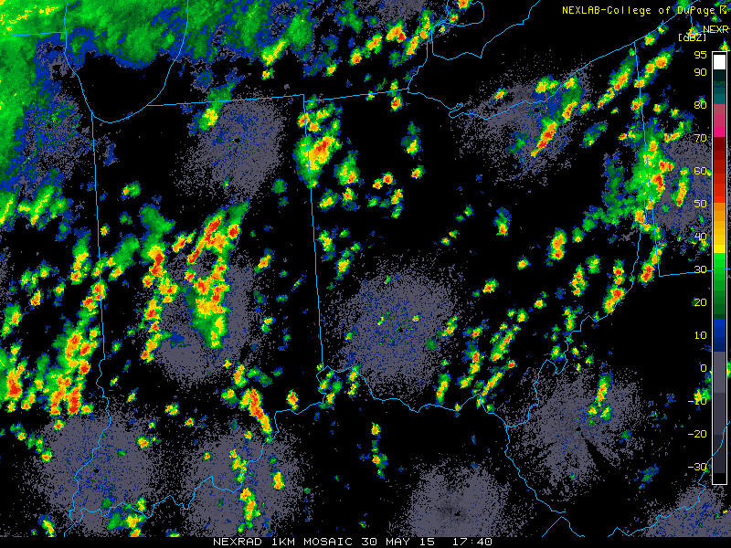
Side note: some areas could see a good bit of rainfall over the next 24 hours.
This Afternoon: Showers and thunderstorms likely, mainly after 3pm. Mostly cloudy, with a high near 80. West wind around 10 mph. Chance of precipitation is 60%. New rainfall amounts between a tenth and quarter of an inch, except higher amounts possible in thunderstorms.
Tonight: Showers and thunderstorms before 1am, then showers and possibly a thunderstorm after 1am. Some of the storms could produce heavy rain. Low around 53. Northeast wind 8 to 16 mph. Chance of precipitation is 100%. New rainfall amounts between 1 and 2 inches possible.
Sunday: Rain and possibly a thunderstorm, mainly before 4pm, then a chance of rain and thunderstorms after 4pm. High near 55. Breezy, with a northeast wind 21 to 23 mph. Chance of precipitation is 90%. New rainfall amounts between a half and three quarters of an inch possible.
flood watch
national weather service cleveland oh
318 pm edt sat may 30 2015
...showers and thunderstorms with heavy rain expected through
sunday...
ohz003-006-007-310330-
/o.new.kcle.fa.a.0002.150530t2000z-150531t2000z/
/00000.0.er.000000t0000z.000000t0000z.000000t0000z.oo/
lucas-wood-ottawa-
including the cities of...toledo...bowling green...port clinton
318 pm edt sat may 30 2015
...flood watch in effect through sunday afternoon...
the national weather service in cleveland has issued a
- flood watch for a portion of northwest ohio...including the
following areas...lucas...ottawa and wood.
- through sunday afternoon
- showers and thunderstorms with very heavy rainfall are expected
to move across the watch area tonight through sunday. widespread
rainfall amounts of 1 to 2 inches are possible with isolated
higher amounts.
- the impacts are expected to remain in small streams and urban
areas. these thunderstorms have the potential to produce
torrential downpours with very high rainfall amounts in a short
time. this type of rain can easily overwhelm poor drainage and
urban areas.
precautionary/preparedness actions...
a flood watch means there is a potential for flooding based on
current forecasts. you should monitor later forecasts and be
alert for possible flood warnings. those living in areas prone to
flooding should be prepared to take action should flooding
develop. stay tuned to weather radio for further details or
updates
coastal hazard message
national weather service cleveland oh
512 pm edt sat may 30 2015
...gusty winds will cause hazardous swimming conditions...
.a cold front is expected to move east across the area tonight
followed by low pressure across ohio and pennsylvania sunday. high
pressure will begin to build south across the area monday.
ohz003-007>012-089-paz001-310515-
/o.new.kcle.bh.s.0001.150531t1000z-150601t1500z/
lucas-ottawa-sandusky-erie oh-lorain-cuyahoga-lake-
ashtabula lakeshore-northern erie-
512 pm edt sat may 30 2015
...beach hazards statement in effect from sunday morning through
monday morning...
the national weather service in cleveland has issued a beach
hazards statement for dangerous swimming conditions...which is in
effect from sunday morning through monday morning.
- hazards...high wave action and dangerous swimming conditions
expected.
- timing...early sunday morning through monday morning.
- location...the entire lake erie shoreline from maumee bay to
ripley new york including the following beaches...maumee bay
state park...east harbor state park...huntington beach...kelleys
island state park...headlands beach state park...presque isle
state park and all private beaches.
- potential impacts...northeast winds of 15 to 25 knots will
create large waves of 3 to 6 feet along the lake erie shoreline.
this will cause dangerous currents to develop making swimming
hazardous.
precautionary/preparedness actions...
swimming risk exists today. the combination of wind and or waves
will make for potentially dangerous conditions for swimmers
including the risk of rip currents. follow the instruction of
local authorities or stay out of the water.
short term forecast
national weather service cleveland oh
428 pm edt sat may 30 2015
ohz003-006-017-302230-
lucas-wood-hancock-
including the cities of...toledo...bowling green...findlay
428 pm edt sat may 30 2015
.now...
a line of showers and thunderstorms will move northeast at 35 mph
and be over the local area by 515 pm this afternoon. the
thunderstorms will produce locally heavy rain and cloud to ground
lightning. gusty winds to 30 mph are also possible with the
thunderstorms. be sure to move indoors to protect yourself from
the dangers associated with lightning.
md 0850 concerning severe potential...watch unlikely for eastern illinois...much of indiana...much of ohio...western pennsylvania...and far southwestern new york
mesoscale discussion 0850
nws storm prediction center norman ok
0623 pm cdt sat may 30 2015
areas affected...eastern illinois...much of indiana...much of
ohio...western pennsylvania...and far southwestern new york
concerning...severe potential...watch unlikely
valid 302323z - 310030z
probability of watch issuance...20 percent
summary...scattered bands of thunderstorms will continue to produce
isolated severe wind/wind damage. a ww is unlikely due to the
isolated nature of the threat.
discussion...bands of newd moving strong to isolated severe storms
will continue through the discussion area over the next couple of
hours. isolated damaging wind gusts remain the primary threat with
these bands...particularly in/near localized bowing segments and
along leading edges of newd-propagating cold pools. weak to moderate
instability and deep unidirectional swly flow aloft should help
maintain storms as they move to the northeast...possibly as far as
western pennsylvania by sunset. the threat is expected to gradually
lessen with time with the loss of daytime heating after about
01-02z. given the isolated nature of the threat...a ww is not needed
at this time.
..cook/thompson.. 05/30/2015
...please see www.spc.noaa.gov for graphic product...
attn...wfo...buf...ctp...pbz...rlx...cle...iln...dtx...lmk...
iwx...ind...pah...lot...ilx...
lat...lon 39598855 40118821 40828720 41528556 41768373 42048136
42477893 42457828 42107793 41387819 40307911 39788040
39578244 39218406 38668549 38178627 37938698 38068775
38528837 39598855
From JR's : articles
2700 words - 17380 chars
- 15 min read
created on
updated on
- #
source
- versions
Related articles
Severe weather threat for Sun, Nov 17, 2013 - Nov 18, 2013
Nov 17, 2013 Toledo area weather notes - Mar 03, 2014
Posts related to Nov 17, 2013 severe weather - Nov 21, 2013
Toledo area weather for early December 2013 - Dec 05, 2013
Mon, Dec 9, 2013 winter storm forecast for Sat, Dec 14 - Dec 14, 2013
more >>