Toledo weather sun jun 14 2015
6:30 a.m., Sun, Jun 14, 2015
I'll provide a simplified view. If JustaSooner is around, he can provide details.
For the first half of June, we experienced fairly active weather or at least above normal rainfall. Nearly three inches of rain has fallen over West Toledo in the first 13 days. Some areas around Toledo have received more.
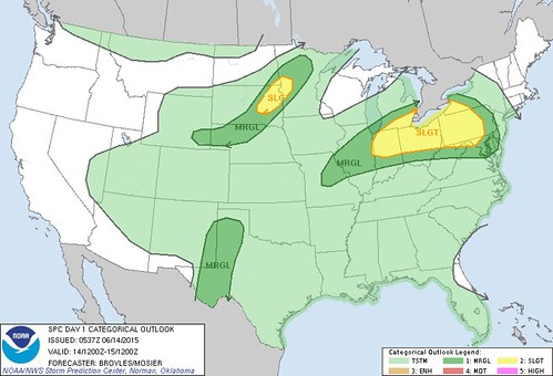
Early this morning, the Storm Prediction Center showed the Toledo area within the Slight Risk for severe weather for today and tomorrow.
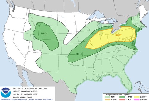
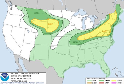
For Tuesday, the risk is forecast to be a little south and east of us, but the National Weather Service said that the entire week could be fairly active.
Localized flooding may be an issue for some parts of northwest Ohio.
Excerpts from this morning's Hazardous Weather Outlook:
national weather service cleveland oh 444 am edt sun jun 14 2015there is a chance for severe thunderstorms today with the potential for strong winds and large hail. locally heavy rain is also likely which could lead to flooding. spotter activation is possible today.
there is a chance for severe thunderstorms again on monday with the potential for strong winds and large hail. heavy rain is also possible which could lead to flooding.
an active weather pattern will persist this week. it is too early to be specific but there may be a chance for severe thunderstorms and heavy rain somewhere in northern ohio each day this week.
Excerpts from the 4:00 a.m. Cle NWS Area Forecast Discussion:
all [variables] point toward an active day [today] of showers and thunderstorms.unsure where the focusing mechanism will occur to get any particular storms stronger than others but with decent cape progged to develop and the above mentioned parameters there will certainly be some storms and clusters of storms that will get strong to severe.
equally concerning is the increasing pw and the thereat for heavy showers/storms on top of the locally heavy rain we have already had in places. will not issue a flood watch at this time since the storms should move along in the brisk southwest flow today but where there is training or back building we will have to watch for flooding. will mention heavy rain with the storms.
Toledo forecast - Last Update: Jun 14, 2015 5:03 am
Today: Showers and thunderstorms likely. Some of the storms could produce heavy rain. Cloudy, with a high near 84. Southwest wind 5 to 14 mph. Chance of precipitation is 70%. New rainfall amounts between a quarter and half of an inch possible.
Tonight: Showers and thunderstorms likely, mainly before 10pm. Cloudy, with a low around 68. Southwest wind 8 to 13 mph. Chance of precipitation is 70%. New rainfall amounts between a quarter and half of an inch possible.
Monday: Showers and thunderstorms likely, mainly after 11am. Cloudy, with a high near 85. West wind 7 to 14 mph. Chance of precipitation is 70%. New rainfall amounts between a tenth and quarter of an inch, except higher amounts possible in thunderstorms.
Monday Night: Showers and thunderstorms likely, mainly before midnight. Mostly cloudy, with a low around 69. Northwest wind around 9 mph. Chance of precipitation is 70%. New rainfall amounts between a tenth and quarter of an inch, except higher amounts possible in thunderstorms.
Tuesday: A chance of showers and thunderstorms. Mostly cloudy, with a high near 80. North wind 6 to 10 mph. Chance of precipitation is 40%. New rainfall amounts of less than a tenth of an inch, except higher amounts possible in thunderstorms.
SPC Convective Outlook for Sun, Jun 14, 2015
SPC Convective Outlook for Mon, Jun 15, 2015
SPC Convective Outlook for Tue, Jun 16, 2015
spc ac 140537
day 1 convective outlook
nws storm prediction center norman ok
1237 am cdt sun jun 14 2015
valid 141200z - 151200z
...there is a slgt risk of svr tstms across parts of the srn great
lakes and cntrl appalachian mtns...
...there is a slgt risk of svr tstms across parts of the nrn
plains...
...there is a mrgl risk of svr tstms across parts of the mid ms
valley...srn great lakes...oh valley...cntrl appalachian mtns and
mid-atlantic...
...there is a mrgl risk of svr tstms across parts of the cntrl and
nrn plains...
...there is a mrgl risk of svr tstms across parts of the srn high
plains...
...summary...
scattered severe thunderstorms will likely develop across parts of
the southern great lakes and central appalachian mountains where
wind damage and isolated large hail will be possible. severe
thunderstorms with hail and isolated wind damage will also be
possible across eastern south dakota and western minnesota. other
marginally severe storms may occur across parts of the mid
mississippi valley...central plains and southern high plains.
...srn great lakes/cntrl appalachian mtns...
a subtle shortwave trough will move newd into the srn great lakes
region today. convection will likely be ongoing at the start of the
period across parts of srn lower mi on the nose of a 30 to 40 kt
low-level jet. sly flow across much of the oh and tn valleys will
keep a very moist airmass in place where sfc dewpoints should
generally be in the upper 60s and lower 70s f. this will result in
the development of moderate instability across a broad warm sector
from the mid ms valley ewd into the cntrl appalachian mtns. as
destabilization occurs...scattered strong to severe thunderstorms
should gradually develop and move ewd across the region.
nam forecast soundings at 21z along the corridor of greatest
instability from columbus oh newd to erie pa show sbcape values from
1500 to 2000 j/kg with a very moist boundary layer. this combined
with unidirectional wind profiles and 25 to 35 kt of 0-6 km shear
should be sufficient for severe multicells. as storms increase in
coverage this afternoon and new cells develop along residual outflow
boundaries...several line segments with wind damage potential appear
likely. hail may also occur but this should be the lesser of the two
threats.
...upper ms valley/nrn and cntrl plains...
an upper-level trough will move across the nrn high plains today as
a well-defined cold front advances sewd across nw mn and sd. ahead
of the front...sfc dewpoints in the lower to mid 60s f should result
in a corridor of moderate instability by afternoon. increasing
low-level convergence along the boundary along with sfc heating
should enable strong to possibly severe thunderstorms to develop
during the mid to late afternoon from wrn mn swwd across ern sd.
other more isolated thunderstorms should initiate across nrn nb and
sern wy.
nam forecast soundings in ern sd and wrn mn at 21z show mlcape near
1500 j/kg with 40 to 45 kt of 0-6 km shear. in addition...low to
mid-level lapse rates are steep which should support a threat for
hail with cells that rotate. isolated wind damage could also develop
with the better organized line segments. further to the southwest in
nrn neb and se wy...lapse rates will also be steep and deep-layer
shear should be adequate for a marginal severe threat for hail and
strong wind gusts.
...srn high plains...
an upper-level trough will move into the srn and cntrl high plains
today as a sfc trough deepens across the srn high plains. to the
east of this feature...a moist airmass will be in place with sfc
dewpoints generally in the upper 50s and lower 60s f. this should
enable an axis of moderate instability to develop across west tx and
ern nm by midday. thunderstorms again should initiate along the wrn
edge of the strongest instability and move ewd across the srn high
plains during the mid to late afternoon. forecast soundings for
00z/mon at midland show mlcape from 1000 to 1500 j/kg with 0-6 km
shear near 25 kt. this along with steep mid-level lapse rates could
be enough for a marginal hail threat. a few strong wind gusts could
also occur.
..broyles/mosier.. 06/14/2015
click to get wuus01 ptsdy1 product
note: the next day 1 outlook is scheduled by 1300z
TOL: (dew point of 71 degrees!!)
Jun 14, 2015 11:52 am
Weather : Mostly Cloudy
Temperature : 81 F
Humidity : 72%
Wind Speed : SW 13 mph - Gust 21 mph
Barometer : 29.98 in
Dewpoint: 71 F
Visibility : 10.00 statute miles
Heat Index : 85 F
(formerly Metcalf Airport)
Jun 14, 2015 11:53 am
Weather : Partly Cloudy
Temperature : 82 F
Humidity : 67%
Wind Speed : SW 15 mph - Gust 21 mph
Barometer : 29.99 in
Dewpoint: 70 F
Visibility : 10.00 statute miles
Heat Index : 86 F
(near Lambertville)
Jun 14, 2015 11:55 am
Weather : Mostly Cloudy
Temperature : 82 F
Humidity : 71%
Wind Speed : W 7 mph
Barometer : 29.98 in
Dewpoint: 71 F
Visibility : 10.00 statute miles
Heat Index : 87 F

At 1:45 pm, the SPC issued a severe thunderstorm watch that's in effect until 9:00 pm

primary threats include...
- scattered damaging wind gusts to 70 mph likely
- isolated large hail events to 1 inch in diameter possible
summary... scattered eastward-moving bands / small clusters of thunderstorms... some a threat for locally damaging wind... expected over parts of the ohio valley and lower great lakes through early tonight.
TOL:
Jun 14, 2015 1:52 pm
Weather : Mostly Cloudy
Temperature : 84 F
Humidity : 65%
Wind Speed : SW 16 mph - Gust 24 mph
Barometer : 29.94 in
Dewpoint: 71 F
Visibility : 10.00 statute miles
Heat Index : 89 F
(formerly Metcalf Airport)
Jun 14, 2015 1:53 pm
Weather : Partly Cloudy
Temperature : 85 F
Humidity : 63%
Wind Speed : SW 20 mph - Gust 29 mph
Barometer : 29.96 in
Dewpoint: 71 F
Visibility : 10.00 statute miles
Heat Index : 90 F
(near Lambertville)
Jun 14, 2015 1:34 pm
Weather : Mostly Cloudy
Temperature : 82 F
Humidity : 76%
Wind Speed : SW 6 mph
Barometer : 29.95 in
Dewpoint: 74 F
Visibility : 10.00 statute miles
Heat Index : 88 F
md 1019 concerning severe thunderstorm watch 299... for central/nrn portions of indiana and oh...sern lower mi...nwrn pa
mesoscale discussion 1019
nws storm prediction center norman ok
0314 pm cdt sun jun 14 2015
areas affected...central/nrn portions of indiana and oh...sern lower
mi...nwrn pa
concerning...severe thunderstorm watch 299...
valid 142014z - 142215z
the severe weather threat for severe thunderstorm watch 299
continues.
summary...the risk for damaging winds continues with the strongest
storms within the watch area.
discussion...scattered thunderstorms were in progress at 2010z
across ww 299...with the greatest concentration over
west-central/northern indiana and southeast lower michigan/northern
ohio where low-level confluence was maximized. the overall
environment remains supportive of isolated to widely scattered
damaging downburst winds with the strongest storms given the very
moist environment /pw values approaching 2 inches/...mlcape of 1000
to 1500 j/kg...and 30-40 kt mid-level flow. in the absence of
large-scale forcing for ascent over the watch area...only a modest
increase in thunderstorm coverage is anticipated. where storms
congeal into clusters or short lines...the threat for damaging winds
may be locally greater.
..bunting.. 06/14/2015
...please see www.spc.noaa.gov for graphic product...
attn...wfo...pbz...cle...iln...dtx...iwx...grr...ind...lot...
lat...lon 39908750 40408746 40598684 41378643 42008448 42348316
41938315 41688283 41648239 41878189 42188127 42327989
41747971 41548005 41008072 40458211 39958384 39558552
39378668 39308740 39908750

TOL
Jun 14, 2015 4:52 pm
Weather : Light Rain
Temperature : 85 F
Humidity : 63%
Wind Speed : WSW 14 mph - Gust 26 mph
Barometer : 29.92 in
Dewpoint: 71 F
Visibility : 10.00 statute miles
Heat Index : 90 F
From JR's : articles
1921 words - 11623 chars
- 10 min read
created on
updated on
- #
source
- versions
Related articles
Severe weather threat for Sun, Nov 17, 2013 - Nov 18, 2013
Nov 17, 2013 Toledo area weather notes - Mar 03, 2014
Posts related to Nov 17, 2013 severe weather - Nov 21, 2013
Toledo area weather for early December 2013 - Dec 05, 2013
Mon, Dec 9, 2013 winter storm forecast for Sat, Dec 14 - Dec 14, 2013
more >>