You're viewing old version number 10. - Current version
Toledo weather mon jun 15 2015
hazardous weather outlook
national weather service cleveland oh
548 am edt mon jun 15 2015
ohz003-006>014-017>023-027>033-036>038-047-089-paz001>003-161000-
lucas-wood-ottawa-sandusky-erie oh-lorain-cuyahoga-lake-geauga-
ashtabula inland-hancock-seneca-huron-medina-summit-portage-trumbull-
wyandot-crawford-richland-ashland-wayne-stark-mahoning-marion-morrow-
holmes-knox-ashtabula lakeshore-northern erie-southern erie-
crawford pa-
548 am edt mon jun 15 2015
this hazardous weather outlook is for north central
ohio...northeast ohio...northwest ohio and northwest pennsylvania.
.day one...today and tonight.
heavy rain is likely again with thunderstorms today and tonight.
areas that see significant thunderstorm activity could be at risk
for flooding and a flood watch may be needed.
isolated severe thunderstorms may develop especially late today
and early tonight ahead of a weak cold front. damaging winds and
large hail are possible.
.days two through seven...tuesday through sunday.
an active weather pattern will persist this week...with strong to
severe thunderstorms and localized heavy rainfall possible on
thursday and again this weekend.
.spotter information statement...
spotter activation may be needed.
flood watch
national weather service cleveland oh
1159 am edt mon jun 15 2015
...flash flooding possible this afternoon and tonight...
.scattered showers and thunderstorms will become more widespread
this evening ahead of a frontal boundary approaching from the
northwest. very moist atmospheric conditions will result in
torrential rainfall and rainfall rates near or exceeding 2 inches
per hour. the soil is already saturated from recent rains in some
areas and flooding could develop quickly.
ohz003-006>014-017>023-027>033-036>038-047-089-paz001>003-160000-
/o.new.kcle.ff.a.0003.150615t1800z-150616t0800z/
/00000.0.er.000000t0000z.000000t0000z.000000t0000z.oo/
lucas-wood-ottawa-sandusky-erie oh-lorain-cuyahoga-lake-geauga-
ashtabula inland-hancock-seneca-huron-medina-summit-portage-
trumbull-wyandot-crawford-richland-ashland-wayne-stark-mahoning-
marion-morrow-holmes-knox-ashtabula lakeshore-northern erie-
southern erie-crawford pa-
including the cities of...toledo...bowling green...port clinton...
fremont...sandusky...lorain...cleveland...mentor...chardon...
jefferson...findlay...tiffin...norwalk...medina...akron...
ravenna...warren...upper sandusky...carey...bucyrus...mansfield...
ashland...wooster...canton...youngstown...marion...mount gilead...
millersburg...mount vernon...ashtabula...erie...edinboro...
meadville
1159 am edt mon jun 15 2015
...flash flood watch in effect through late tonight...
the national weather service in cleveland has issued a
- flash flood watch for portions of ohio and northwest
pennsylvania...including the following areas...in ohio...
ashland...ashtabula inland...ashtabula lakeshore...crawford...
cuyahoga...erie oh...geauga...hancock...holmes...huron...
knox...lake...lorain...lucas...mahoning...marion...medina...
morrow...ottawa...portage...richland...sandusky...seneca...
stark...summit...trumbull...wayne...wood and wyandot. in
northwest pennsylvania...crawford pa...northern erie and
southern erie.
- through late tonight
- thunderstorms this afternoon and tonight will be capable of
producing intense rainfall...with rainfall rates in excess of 2
inches per hour. some areas will have multiple rounds of
thunderstorms...each increasing the threat for flash flooding.
- localized areas of flash flooding...as well as quick rises on
area creeks and streams will be likely from the heavy rainfall.
urban flooding can occur very quickly...especially at
underpasses and poor drainage areas.
precautionary/preparedness actions...
a flash flood watch means that conditions may develop that lead
to flash flooding. flash flooding is a very dangerous situation.
rapid rises of rivers and creeks are possible. if you are in the
watch area you should monitor weather conditions closely. be ready
to move to higher ground if flooding is observed or a warning is
issued. stay tuned to weather radio for further updates.
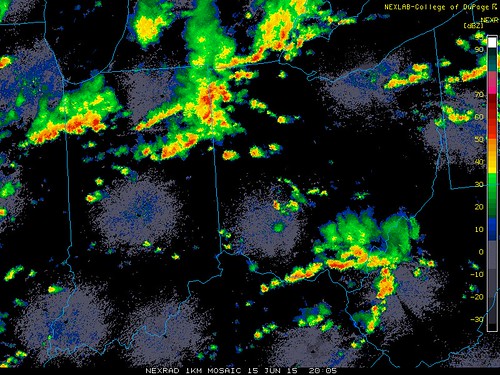
At 4:02 p.m., a severe thunderstorm warning was issued for parts of Paulding and Defiance counties.
Radar snapshot, 4:05 p.m., Mon, Jun 15, 2015. Rain is moving mainly eastward.
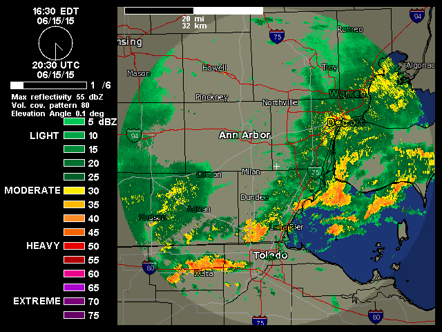
All of the region is under a Flash Flood Watch.
This afternoon (Mon, Jun 15), parts of southeast Michigan, including the counties of Monroe and Lenawee, were issued an Urban and Small Stream Flood Advisory.
According to radar, around one-inch of rainfall has fallen this afternoon over parts of southeast Michigan, which received between one and two inches of rainfall yesterday. Much of our region received a fair amount of rainfall during the previous week or so.
Jun 15, 2015 3:52 pm
Weather : A Few Clouds
Temperature : 84 F
Humidity : 65%
Wind Speed : SW 8 mph
Barometer : 29.91 in
Dewpoint: 71 F
Visibility : 10.00 statute miles
Heat Index : 89 F
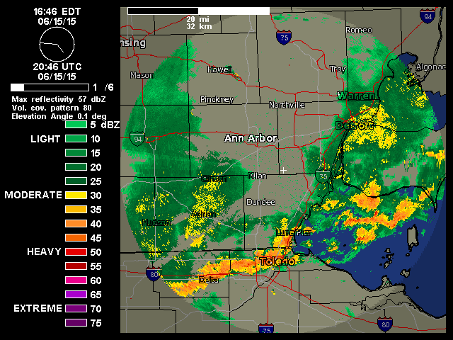
This is only a 6-minute loop from 4:30 to 4:36 p.m. The rain areas have expanded quickly in the Toledo area over the past hour or so. In fact, the latest radar image shows much of Toledo covered by heavy rainfall.
This may cause some street flooding.
Forecast.io data with my text-reps:
Central Toledo "Heavy rain for the hour"
Next Hour: Heavy rain for the hour.
5:05 pm 100 chance of very heavy rain
5:06 pm 100 chance of very heavy rain
5:07 pm 100 chance of very heavy rain
5:08 pm 100 chance of very heavy rain
5:09 pm 100 chance of very heavy rain
5:10 pm 100 chance of heavy to very heavy rain
5:11 pm 100 chance of heavy to very heavy rain
5:12 pm 100 chance of heavy rain
5:13 pm 100 chance of heavy rain
5:14 pm 100 chance of moderate to heavy rain
5:15 pm 100 chance of moderate to heavy rain
5:16 pm 100 chance of moderate to heavy rain
5:17 pm 99 chance of moderate to heavy rain
5:18 pm 99 chance of moderate to heavy rain
5:19 pm 99 chance of heavy rain
5:20 pm 99 chance of heavy rain
5:21 pm 100 chance of heavy to very heavy rain
5:22 pm 100 chance of heavy to very heavy rain
5:23 pm 100 chance of very heavy rain
5:24 pm 100 chance of very heavy rain
5:25 pm 100 chance of very heavy rain
5:26 pm 100 chance of very heavy rain
5:27 pm 100 chance of very heavy rain
5:28 pm 100 chance of heavy to very heavy rain
5:29 pm 100 chance of heavy to very heavy rain
5:30 pm 100 chance of heavy to very heavy rain
5:31 pm 100 chance of heavy rain
5:32 pm 100 chance of heavy rain
5:33 pm 100 chance of heavy rain
5:34 pm 100 chance of heavy rain
5:35 pm 100 chance of moderate to heavy rain
5:36 pm 100 chance of moderate to heavy rain
5:37 pm 100 chance of moderate to heavy rain
5:38 pm 100 chance of moderate to heavy rain
5:39 pm 100 chance of moderate to heavy rain
5:40 pm 100 chance of moderate to heavy rain
5:41 pm 100 chance of moderate to heavy rain
5:42 pm 100 chance of moderate to heavy rain
5:43 pm 100 chance of moderate to heavy rain
5:44 pm 100 chance of moderate to heavy rain
5:45 pm 100 chance of moderate to heavy rain
5:46 pm 100 chance of moderate to heavy rain
5:47 pm 100 chance of moderate to heavy rain
5:48 pm 100 chance of moderate to heavy rain
5:49 pm 100 chance of moderate to heavy rain
5:50 pm 100 chance of moderate to heavy rain
5:51 pm 100 chance of moderate to heavy rain
5:52 pm 100 chance of moderate to heavy rain
5:53 pm 100 chance of moderate rain
5:54 pm 100 chance of moderate rain
5:55 pm 100 chance of moderate rain
5:56 pm 100 chance of moderate rain
5:57 pm 100 chance of moderate rain
5:58 pm 100 chance of moderate rain
5:59 pm 100 chance of moderate rain
6:00 pm 100 chance of moderate rain
6:01 pm 100 chance of moderate rain
6:02 pm 100 chance of moderate rain
6:03 pm 100 chance of moderate rain
6:04 pm 100 chance of moderate rain
6:05 pm 100 % chance of moderate rain
Oregon - "Heavy rain for the hour"
Next Hour: Heavy rain for the hour.
5:05 pm 100 chance of moderate to heavy rain
5:06 pm 100 chance of moderate rain
5:07 pm 100 chance of moderate rain
5:08 pm 100 chance of moderate rain
5:09 pm 100 chance of moderate rain
5:10 pm 100 chance of light to moderate rain
5:11 pm 99 chance of light to moderate rain
5:12 pm 97 chance of light to moderate rain
5:13 pm 98 chance of moderate rain
5:14 pm 98 chance of moderate rain
5:15 pm 97 chance of moderate rain
5:16 pm 95 chance of moderate rain
5:17 pm 92 chance of light to moderate rain
5:18 pm 88 chance of light to moderate rain
5:19 pm 88 chance of light to moderate rain
5:20 pm 84 chance of light to moderate rain
5:21 pm 79 chance of light to moderate rain
5:22 pm 76 chance of light to moderate rain
5:23 pm 77 chance of light to moderate rain
5:24 pm 79 chance of light to moderate rain
5:25 pm 78 chance of light to moderate rain
5:26 pm 79 chance of light to moderate rain
5:27 pm 79 chance of light to moderate rain
5:28 pm 82 chance of moderate rain
5:29 pm 83 chance of moderate rain
5:30 pm 87 chance of moderate rain
5:31 pm 87 chance of moderate to heavy rain
5:32 pm 90 chance of moderate to heavy rain
5:33 pm 92 chance of moderate to heavy rain
5:34 pm 93 chance of moderate to heavy rain
5:35 pm 94 chance of heavy rain
5:36 pm 96 chance of heavy rain
5:37 pm 96 chance of heavy rain
5:38 pm 97 chance of heavy rain
5:39 pm 98 chance of heavy rain
5:40 pm 99 chance of heavy rain
5:41 pm 99 chance of heavy rain
5:42 pm 99 chance of heavy rain
5:43 pm 99 chance of heavy rain
5:44 pm 99 chance of heavy rain
5:45 pm 100 chance of heavy rain
5:46 pm 100 chance of heavy rain
5:47 pm 100 chance of moderate to heavy rain
5:48 pm 100 chance of moderate to heavy rain
5:49 pm 100 chance of moderate to heavy rain
5:50 pm 100 chance of moderate to heavy rain
5:51 pm 100 chance of moderate to heavy rain
5:52 pm 100 chance of moderate to heavy rain
5:53 pm 100 chance of moderate to heavy rain
5:54 pm 100 chance of moderate to heavy rain
5:55 pm 100 chance of moderate to heavy rain
5:56 pm 100 chance of moderate to heavy rain
5:57 pm 100 chance of moderate to heavy rain
5:58 pm 100 chance of moderate to heavy rain
5:59 pm 100 chance of moderate to heavy rain
6:00 pm 100 chance of moderate to heavy rain
6:01 pm 100 chance of moderate to heavy rain
6:02 pm 100 chance of moderate rain
6:03 pm 100 chance of moderate rain
6:04 pm 100 chance of moderate rain
6:05 pm 100 % chance of moderate rain
Mon evening, Jun 15, 2015 - Toledo Blade - Heavy rain brings deep water on city streets
High water on the streets made driving difficult in parts of Toledo during the rush hour today, but it didn't shut down any roads, according to the Toledo Police Department.
"Due to heavy rain, cars are stalled in high water on Bancroft St. west of Detroit Ave. in Toledo."

https://www.facebook.com/ToledoNewsNow
image - looks like something out of Independence Day.

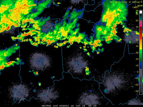
8:20 p.m. radar snapshot. Rain was moving east.
Naturally, I turn to Family Guy for analysis.

From JR's : articles
1763 words - 11107 chars
- 9 min read
created on
updated on
- #
source
- versions
Related articles
Severe weather threat for Sun, Nov 17, 2013 - Nov 18, 2013
Nov 17, 2013 Toledo area weather notes - Mar 03, 2014
Posts related to Nov 17, 2013 severe weather - Nov 21, 2013
Toledo area weather for early December 2013 - Dec 05, 2013
Mon, Dec 9, 2013 winter storm forecast for Sat, Dec 14 - Dec 14, 2013
more >>