Toledo weather sun jun 21 2015
the morning HWO did not mention a risk for storms on Monday even though the SPC's Day 2 convective outlook showed the Toleod area barely contained within the Slight Risk for severe thunderstorms.
The Day 2 convective outlook is the same. I think someone on a later shift at the Cle NWS realized the earlier miss. Maybe a person remembered that Lucas County is part of the Cle NWS's CWA.
hazardous weather outlook
national weather service cleveland oh
1124 am edt sun jun 21 2015
for lake erie...north central
ohio...northeast ohio...northwest ohio and northwest pennsylvania.
.day one...this afternoon and tonight.
hazardous weather is not expected at this time.
.days two through seven...monday through saturday.
there is a chance for severe storms later monday and monday
night.
severe thunderstorms are expected to develop across the central
great lakes on monday. these storms will likely move toward lake
erie. it is uncertain at this time how long and how far east the
severe storms will persist. the best chance for severe storms
appears to be across northwest ohio. wind damage and large hail
will be the greatest threat although a tornado is possible.
.spotter information statement...
spotter activation may be necessary monday or monday night.
spc ac 210602
day 2 convective outlook
nws storm prediction center norman ok
0102 am cdt sun jun 21 2015
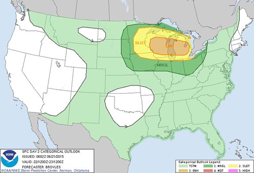
valid 221200z - 231200z
...there is an enh risk of svr tstms across parts of far se
mn...wi...lake michigan and lower mi...
...there is a slgt risk of svr tstms across parts of the upper ms
valley and great lakes region...
...there is a mrgl risk of svr tstms across parts of the nrn
plains...mid to upper ms valley...great lakes region and nrn oh
valley...
...summary...
severe thunderstorms will be possible across the upper mississippi
valley and great lakes region on monday where a few
tornadoes...damaging wind gusts and isolated large hail may occur. a
threat for strong tornadoes and wind gusts of greater than 65 knots
will be possible. marginally severe thunderstorms may occur across
the mid missouri valley...mid to upper mississippi valley and
northern ohio valley.
...upper ms valley/great lakes region...
a vigorous upper-level trough will move ewd across the nrn plains
into the upper ms valley on monday as an impressive 60 to 80 kt
mid-level jet overspreads the upper ms valley and great lakes
region. at the sfc...a low is forecast to move quickly newd from the
mid mo valley into the great lakes region as a cold front advances
sewd into the upper ms valley. ahead of the front...a very moist
airmass should be in place with sfc dewpoints in the lower 70s f
which should enable moderate to strong instability to develop across
much of the mid to upper ms valley by afternoon.
in addition to the strong instability...model forecasts show
impressive shear profiles and an upper-level system that appears
quite organized with a well-defined low to mid-level jet couplet.
this could result in a significant event occurring across parts of
the upper ms valley and great lakes region on monday. considering
the nam...gfs and ecmwf models...the nam and gfs appear to the be
most aggressive solutions while the ecmwf is slightly more
conservative concerning the amount of instability...shear and
organization with the upper-level system. many problems exist for
determining the most likely corridor for severe including 1) how
morning convection will impact the setup in the afternoon and 2) how
far north will the capping inversion impede convective development.
the current thinking is that a morning mcs with wind damage
potential will track esewd from ern mn and ern ia across srn
wi...nrn il and into ind around midday. further west behind the
morning mcs...an axis of strong instability will develop from nrn mo
nwd into ern ia with new convection initiating on the nrn end of the
strong instability in far se mn and nwrn wi during the afternoon.
this convection should move ewd and gradually grow upscale. nam
forecast soundings at 21z on monday for madison wi show impressive
thermodynamics and shear profiles with mlcape above 4000 j/kg and
0-6 km shear from 60 to 70 kt. this would be very favorable for
severe storms including supercells. it seems possible that a cluster
of supercells could organize during the mid to late
afternoon...moving ewd across cntrl and ern wi and crossing lake mi
into lower mi by early evening. strong low-level shear could support
a threat for strong tornadoes and a long-track tornado can not be
ruled out. the other possibility is for a severe wind producing
linear mcs that moves quickly esewd across wi during the late
afternoon reaching lower mi by early evening. due to the possibility
of a high-end event for either tornadoes or wind damage...the
enhanced area will be expanded to include most of wi and lower mi
with the significant hatched area also including sern mn.
..broyles.. 06/21/2015
click to get wuus02 ptsdy2 product
note: the next day 2 outlook is scheduled by 1730z

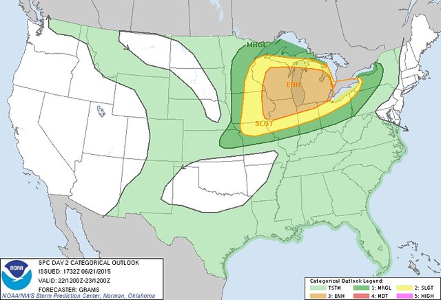
spc ac 211732
day 2 convective outlook
nws storm prediction center norman ok
1232 pm cdt sun jun 21 2015
valid 221200z - 231200z
...there is an enh risk of svr tstms great lakes and upper ms
valley...
...there is a slgt risk of svr tstms from the upper midwest to lower
great lakes...
...there is a mrgl risk of svr tstms across parts of the n-cntrl/ne
states...
...summary...
scattered severe storms are likely across parts of the upper
mississippi valley and great lakes regions...some of which should be
intense...mainly from midday through the evening on monday.
...upper ms valley/great lakes...
strongly considered an upgrade to moderate risk with potential for
clusters of intense severe storms with all significant severe
hazards possible. but will defer given enough uncertainty with
regard to evolution of late d1 convection with its subsequent effect
on the degree of downstream diurnal destabilization...along with
timing of the pair of mid-level shortwave impulses with respect to
peak heating.
guidance is consistent in depicting strengthening
low/mid-tropospheric flow in response to a convectively-generated
mcv from late d1/early d2 and approach of an upstream shortwave
trough currently over the srn canadian rockies. these features would
enhance low-level waa of the richly buoyant air mass currently
present over the lower mo valley. available cams vary markedly with
the daytime evolution of an mcs expected to be ongoing across parts
of srn mn/nrn ia. it seems plausible that this activity should
persist through the day with an organized severe risk on the edge of
a robust plains eml. this type of scenario may result in lead
convection outpacing the more favorable thermodynamic environment
characterized by rather steep mid-level lapse rates and very large
buoyancy.
at least scattered upstream tstm development should occur by late
afternoon along the cold front from cntrl/ern wi sw to the ia/il
border area as convergence along the front and diabatic heating
overcome inhibition due to the initially stout eml. supercells are
expected in initial stages of development...with some of this
convection growing upscale during the evening. with low-level flow
becoming increasingly veered in the wake of the lead mid-level
impulse...main hazards with sw extent should be very large hail
transitioning to predominately severe wind. where 850 mb winds can
remain quite strong with enlarged low-level hodographs /most likely
in ern wi to lower mi/...a risk for strong tornadoes and/or
significant severe wind gusts may develop.
..grams.. 06/21/2015
click to get wuus02 ptsdy2 product
note: the next day 2 outlook is scheduled by 0600z
At early Sun afternoon, Jun 21, the SPC increased the sizes for Slight Risk and Enhanced Risk, regarding chances for severe weather for Mon, Jun 22.
The biggest chances for severe weather remain north and west of Toledo.
Forecast issued at 1:32 p.m. EDT on Sun, Jun 21 for Mon, Jun 22
Probability of severe weather within 25 miles of a point on Mon, Jun 22.
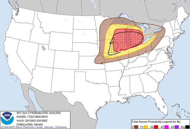
Excerpts from the 1:32 p.m., Sun, Jun 21 Day 2 Convective Outlook for Mon, Jun 22:
strongly considered an upgrade to moderate risk with potential for clusters of intense severe storms with all significant severe hazards possible. but will defer given enough uncertainty ...... most likely in ern wi to lower mi/ ...a risk for strong tornadoes and/or significant severe wind gusts may develop.
This afternoon's version of the Day 2 Convective Outlook seemed a little less ominous than the Day 2 forecast that was issued very early this morning.
... this would be very favorable for severe storms including supercells. it seems possible that a cluster of supercells could organize during the mid to late afternoon [Monday] ...moving ewd across cntrl and ern wi and crossing lake mi into lower mi by early evening.strong low-level shear could support a threat for strong tornadoes and a long-track tornado can not be ruled out.
the other possibility is for a severe wind producing linear mcs that moves quickly esewd across wi during the late afternoon reaching lower mi by early evening.
It does appear that the weather could be bumpy on Monday over the western half of Michigan's lower peninsula.
It's uncertain if a thunderstorm cluster will remain strong enough to be severe by the time it reaches the Toledo area on Monday evening.
Excerpts from the 11:24 a.m., Sun, Jun 21 Hazardous Weather Outlook, issued by the Cle NWS:
severe thunderstorms are expected to develop across the central great lakes on monday. these storms will likely move toward lake erie. it is uncertain at this time how long and how far east the severe storms will persist.the best chance for severe storms appears to be across northwest ohio. wind damage and large hail will be the greatest threat although a tornado is possible.
[SKYWARN] spotter activation may be necessary monday or monday night.
this is a bit macabre, but I wonder if someone has started a gambling pool where people can bet on which counties (or parts of a county) will receive a tornado warning. ghoulish.
it's 4:15 p.m., on sun, jun 21, 2015. limit it to three bets.
- van wert county, ohio is always my obvious choice. but this may not be a good choice because van wert resides at or below the very edge of the enhanced risk area. no ohio county may be good bet, but i'll stick with van wert because historically, van wert is a severe thunderstorm magnet in ohio.
- kalamazoo county in michigan
- clinton county in michigan
- one more since van wert was kind of a wild guess. i'll say elkhart county in indiana
http://www.digital-topo-maps.com/county-map/michigan-county-map.gif
http://www.muskingumcounty.org/images/ohio-county-map.gif
http://www.digital-topo-maps.com/county-map/indiana-county-map.gif
TOL:
Jun 21, 2015 7:52 pm
Weather : Fair
Temperature : 81 F
Humidity : 53%
Wind Speed : WNW 8 mph
Barometer : 29.92 in
Dewpoint: 62 F
Visibility : 10.00 statute miles
Heat Index : 82 F
fxus63 kdtx 212333
afddtx
area forecast discussion
national weather service detroit/pontiac mi
733 pm edt sun jun 21 2015
aviation...
bkn cu field over southeastern michigan has evolved into benign
agitated cumulus with maturation of the boundary layer. there
remains a low potential that an iso shower or thunderstorm can
generate off of area lake breeze/convergence
boundaries. the better potential is across the thumb and saginaw
bay region with satellite trends suggesting the potential for the
southern taf sites has seemingly ended. skc or sct cirrus will
prevail tonight under weak high pressure. the attention is on a
potential high impact severe thunderstorm risk for monday
afternoon and evening. did not introduce any specific time window
for tsra with this issuance as prefer some convection allowing
model output. gusty south winds are expected tomorrow in advance
of the low pressure system and attendant cold front.
//dtw threshold probabilities...
- low potential for ceiling at 5000 ft agl or less tonight.
- low confidence in thunderstorm timing monday afternoon and
evening. most recent estimate is between 22-02z.
&&
prev discussion...issued 357 pm edt sun jun 21 2015
short term... afternoon and tonight
showers as a result of shallow convection within the weak cold front
are exiting the ohio border region with the front itself at press
time. satellite imagery and surface observations indicate boundary
layer mixing is accomplishing a notable trend toward borderline
broken/scattered cloud coverage with some vertical development over
the rest of se michigan. the exception being near clear sky in
vicinity of the saginaw bay/lake huron stable layer interior thumb.
expect an additional shower or thunderstorm just about anywhere
within the area of more fully developed cumulus with the best chance
now setting up roughly along and west/south of i-75/i-69 with
emphasis on localized convergence in lake breeze regions from about
port huron to the detroit river. the area south of m-59 will have
the best combination of lingering low level moisture to produce
surface based instability near 1500 j/kg during peak heating from
late afternoon through early evening. that being said...the
fragility of moisture quality is also indicated by 100 mb mlcape
struggling to remain above 500 j/kg in hourly mesoanalysis. this
will limit the strongest convection to a heavy downpour and perhaps
a downburst wind gust near 40 mph until dissipation after sunset.
weak surface high pressure will take control overnight and promote a
clearing trend with light and variable wind. this will result in
tranquil conditions with min temps settling into the mid 50s to
around 60 by sunrise monday.
long term...monday through next sunday
model guidance continues to show stronger consensus with synoptic
features that will be important in forecasting the potential severe
weather event over the western and central great lakes monday and
monday night. shearing upper wave seen on water vapor over
alberta/saskatchewan will race east tonight and monday...phasing with
another upper wave now off the coast of northern california...and
probably several other convectively induced smaller waves. resulting
mid-level height falls and a coupled jet structure (both jets
seasonably strong at over 100 knots) over the western/northern great
lakes will result in robust intensification of the surface cyclone
as it lifts from wisconsin to ontario late monday into monday night.
models have also been keying in on a 80 knot speed max at h500
punching into northern and central lower michigan during the
evening.
highest severe potential for southeast michigan will exist roughly
in a 4pm to 2am window...tied in large part to the warm front as it
lifts northward during the evening and then to the cold front as it
drops southeast through the area overnight. convection developing
upstream and racing into michigan may also play a significant role in
timing. will have to monitor this tomorrow...and adjust this window
if necessary. high shear/fairly strong instability/high moisture
environment will bring the entire spectrum of severe weather
threats...damaging winds in excess of 70 mph...large
hail...tornadoes...and localized flash flooding.
warm front and trailing strong surge of low/mid level theta-e could
trigger an initial round of storms during the late afternoon and
evening. airmass looks to achieve temperatures in the low to mid 80s
with surface dewpoints in the upper 60s. this should allow upwards
of a few thousand j/kg of cape to build...both from daytime heating
and thermal advection into the area. this instability does look to
linger through the overnight hours as we see a continuing feed of
warm air and moisture. despite nocturnal timing...this will keep
conditions favorable for severe weather overnight as either the cold
front slices through the area...or an upstream mcs moves in from the
west and is maintained by the environment over lower michigan.
although anything coming in from the west would encounter the cooler
waters of lake michigan...low level jet looks positioned in a way
where it would maintain the strength of an mcs. models have been
consistent with surging a strong 50-60 knot low-level jet up into
the area during the evening. shear profiles continue to look very
impressive...with 0-6 km bulk shear values as high as 60 knots...in
addition to 0-1/0-3 km helicity values high enough to support a
tornado threat. still some question with how timing of instability
and moisture will coincide with best lift and shear...and this will
be an actively evolving situation we will have to watch very closely
tomorrow.
marine...
an isolated shower or thunderstorm will be possible during the
evening near shoreline areas. after that...weak high pressure will
maintain light and variable wind over all marine areas tonight.
southerly winds will then increase monday as strong low pressure
tracks toward the northern great lakes. this system will bring the
potential for strong to severe thunderstorms from monday afternoon
through monday night. while thunderstorms will be the primary
concern...there will also be a period of stronger west to northwest
winds along and behind a cold front monday night into tuesday. cold
lake waters...as low as 39f in the latest buoy observations from
northern lake huron...will support strong stability. this will limit
sustained wind to about 25 knots with gusts around 30 knots
possible. the wind will decrease by late tuesday and tuesday night
as high pressure builds into the region.
&&
dtx watches/warnings/advisories...
mi...none.
lake huron...none.
lake st clair...none.
michigan waters of lake erie...none.
&&
$$
aviation.....cb
short term...bt
long term....hlo
marine.......hlo
you can obtain your latest national weather service forecasts online
at www.weather.gov/detroit (all lower case).
fxus63 kiwx 212348
afdiwx
area forecast discussion
national weather service northern indiana
748 pm edt sun jun 21 2015
synopsis...
issued at 539 pm edt sun jun 21 2015
focus is shifting to the potential for severe storms from mid to
late monday afternoon into early monday night as a strong upper
level system tracks eastward through the great lakes. lows tonight
will be in the mid 60s. highs monday will generally be in the
upper 80s.
&&
short term...(this evening through monday)
issued at 539 pm edt sun jun 21 2015
primary focus on potnl severe with even extreme damaging wind potnl
with well developed qlcs pushing through cwa early monday night. in
near term have squelched pops overnight. upstream focus along slowly
newd retreating warm fntl bndry invof i70 showing deficiency in
upwind sustainence. with refocus of low level jet farther wwd with
time overnight...increasing blcin and wnw steering flow anticipate
little chc for convection acrs cwa overnight...espcly given totality
of swd composite outflow from last nights convection. attention
turns to potnl for xtrm destabilization acrs swrn grtlks on order of
4500-5500 j/kg by late aftn in axis sern wi to srn ia/nwrn mo and
lesser secondary axis acrs nern il movg through nwrn cwa...where
isold supercells ahead of primary axis may form amid 50kts deep
layer shear with large sweeping helical hodos...as highly ramped
westerlies on order of 70-85kts into western lwr mi. strong updraft
rotation/0-1km helicity could also be enhanced should cooler lake
environment slow nwd push of sfc warm fntl bndry/lake enhanced
triple point. in 00 utc to 06 utc timeframe primary well developed
qlcs expected to sweep through cwa. strong wind profiles/storm
motion with preferred deep lyr shear/storm motion vectoring fostering
good cold pool balance.
&&
long term...(monday night through sunday)
issued at 539 pm edt sun jun 21 2015
cdfnt expected to move across the area monday night... psbly
accompanied by a line of svr storms as front encounters extremely
unstable airmass and strong deep layer winds with 35-45kt 0-6km
shear in place. greatest svr threat is north of u.s. 24 with
instability diminishing somewhat by the time the front reaches se
portion of the cwa later monday night. high pressure will build
in behind this cdfnt providing fair wx tue. as the high moves east
wed... the front will lift back north into our area with a wave
movg east along it from the plains... likely causing tstms in our
area by wed ngt into thu. front will prbly sag far enough south in
wake of this system for dry wx fri... but another wave may move
into the area bringing an increased chc of tstms again by sat.
temps through this period should generally be near or slightly blo
normal with no extreme summer heat in sight for our area attm.
&&
aviation...(for the 00z tafs through 00z monday evening)
issued at 743 pm edt sun jun 21 2015
ridge of high pressure over the area this eve will move to the east
tonight allowing light southerly flow to develop overnight.
generally vfr conditions expected overnight but some mvfr vsby
restrictions psbl around daybreak due to radiational cooling
combined with slight increase in low level moisture. a diffuse
warm front will move through the area by early aftn monday
shifting winds from s to sw. sw winds should gust into the 25-30kt
range monday aftn as a seasonally strong low pressure system
tracks east across the upr midwest. airmass expected to become
extremely unstable in the warm sector of this low... including nrn
indiana monday aftn with strong deep layer shear. arw/nmm suggests
storms which develop in vcnty of cdfnt/shrtwv this eve over the
nrn plains will survive through the day monday and move into nw
indiana ahead of the cdfnt monday aftn... with a second line along
the front arriving monday night... hwvr nam hires and spc 4km wrf
suggest warm sector will be capped and dry. another scenario not
fcst by the convective allowing models is that isolated storms
will develop in the warm sector in the aftn. given considerable
uncertainty on convective evolution with this system left ts out
of the tafs through monday aftn with contd vfr conditions...though
will likely need to add ts for the monday eve period with later
tafs.
&&
iwx watches/warnings/advisories...
in...none.
mi...none.
oh...none.
lm...small craft advisory from 2 pm monday to midnight edt monday
night for lmz043-046.
&&
$$
synopsis...murphy
short term...murphy
long term...lewis/jt
aviation...jt
visit us at www.weather.gov/iwx (all lower case)
follow us on facebook...twitter...and youtube at:
www.facebook.com/nwsnorthernindiana
www.twitter.com/nwsiwx
www.youtube.com/nwsnorthernindiana
area forecast discussion
national weather service cleveland oh
621 pm edt sun jun 21 2015
synopsis...
a weak cold front/trough will swing across the area this evening.
the weak front/trough will stall south of the area tonight then
lift back to the north as a warm front monday. a deepening low
pressure system will cross the great lakes on monday with the
associated cold front sliding southeast across the area late
monday night or tuesday morning. high pressure will slide across
the eastern great lakes wednesday.
&&
near term /until 6 am monday morning/...
update...decreased cloud cover through the evening otherwise no
big changes.
original...the weak cold front/trough was over north central
ohio moving southeast. another very weak trough was sliding across
southeast lower mi toward lake erie. i think any additional
showers with the trailing trough will slide just north of toledo
and will keep the i-75 corridor dry this evening. elsewhere will
allow for showers/local thunder through mid evening or so until
the trough(s) and instability are east of the area.
with winds becoming light and dewpoints dropping we should see temps
settle down to comfortable levels tonight. lows from the upper 50s
in the cooler spots to mainly lower 60s elsewhere.
&&
short term /6 am monday morning through wednesday night/...
interesting pattern for monday into tuesday with a deepening
surface low crossing the upper great lakes and increasing low and
mid level jet developing across the great lakes and an
unseasonably strong upper jet pushing in from the northern plains.
this will likely result in clusters of thunderstorms...some
severe...across the central great lakes.
a few warm advection thunderstorms are possible across the
forecast area monday as the humid air pushes back north. sometimes
in a warming atmosphere things end up being capped but will have
a low pop chance for a warm advection thunderstorm on monday for
nw and north central ohio.
not sure if the severe storms will move east southeast monday
night toward erie pa or perhaps more likely dive south southeast
into the most unstable air. this would put western lake erie and
northwest ohio...especially the toledo area...in the threat for
severe storms. the timing...after dark...becomes less favorable
for a continuation of severe storms. will continue to mention the
threat in the hazardous weather outlook for now and not emphasize
it in the forecast just yet. highs in the lower and mid 80s monday
with some upper 80s northwest and north central ohio.
the front should slide southeast of the area tuesday morning.
with the cold advection and decent jet dynamics aloft there will
likely be morning showers/thunder especially across ne oh/nw pa.
lowering dewpoints from northwest to southeast tuesday afternoon and
evening. took the showers out of the forecast for wednesday. withhigh
pressure moving just east of the area it seems as though the air
mass will likely be stable enough that the warm advection showers
will remain to the west and south of the area. highs near normal
wednesday except cooler near lake erie.
&&
long term /thursday through sunday/...
the active weather pattern continues right through the extended
forecast as we transition from zonal flow across the northern tier
of the country to a trough developing over the great lakes region.
long range models all bring the next wave of low pressure through
the upper ohio valley on thursday. the gfs is a little farther north
and slower than the ecmwf/gem. leaning towards the more southern
solution at this time given how far south the front is located ahead
of the system on wednesday night but generally left forecast in tact
with likely pops most areas except chance in the ne. highs are on
the cool side in the upper 70s given the expected clouds and
showers. friday should be dry with high pressure over the central
great lakes followed by another wave riding along the boundary on
saturday. timing of shortwaves and associated low pressure systems
is below normal towards the end of the week and adjustments to the
forecast will be needed. temperatures will generally be near to
slightly below normal.
&&
aviation /18z sunday through friday/...
a sct band of showers extending from tol-cle-yng at 18z will sink
south through mid afternoon. ceilings are generally vfr but may
briefly drop to mvfr in showers. clouds near 5k feet will start to
scatter out from north to south after 21z. winds will generally
range from sw to nw as a weak trough sinks south today. patchy
mvfr visibilities may develop after 06z...mainly at mfd/cak/yng.
southerly winds with vfr conditions most of the day on monday.
outlook...patchy non vfr early morning monday. non vfr likely
early tuesday and again thursday in showers and thunderstorms.
&&
marine...
frontal boundary in the vicinity of lake erie will gradually weaken
this evening with a ridge building in overnight. low pressure will
track from the midwest across the upper great lakes late monday with
southwesterly winds increasing to 20-25 knots monday night and early
tuesday. a small craft advisory will likely be needed...especially
east of vermilion. high pressure builds east across the great lakes
from tuesday into wednesday. another low pressure system is expected
to track through the upper ohio valley on thursday.
&&
cle watches/warnings/advisories...
oh...none.
pa...none.
marine...none.
&&
$$
synopsis...kosarik
near term...tk/kosarik
short term...kosarik
long term...kec
aviation...kec
marine...kec
Excerpts from the Sunday evening Area Forecast Discussions, issued by the three regional NWS offices that cover the Toledo area. Some disagreements exists, regarding the possible strength of storms that may pass through our area after dark on Monday evening.
MCS = Mesoscale Convective System. A complex of thunderstorms which becomes organized on a scale larger than the individual thunderstorms, and normally persists for several hours or more.
QLCS = Quasi-linear Convective System - ???? - "squall lines and bow echoes"
JustaSooner will have to explain the difference between MCS and QLCS.
Cle:
not sure if the severe storms will move east southeast monday night toward erie pa or perhaps more likely dive south southeast into the most unstable air. this would put western lake erie and northwest ohio... especially the toledo area ...in the threat for severe storms. the timing...after dark...becomes less favorable for a continuation of severe storms.
N. IN.
primary focus on potnl severe with even extreme damaging wind potnl with well developed qlcs pushing through cwa early monday night.greatest svr threat is north of u.s. 24 with instability diminishing somewhat by the time the front reaches se portion of the cwa later monday night.
... in 00 utc to 06 utc timeframe primary well developed qlcs expected to sweep through cwa.
Det/Pon
highest severe potential for southeast michigan will exist roughly in a 4pm to 2am window.high shear/fairly strong instability/high moisture environment will bring the entire spectrum of severe weather threats...damaging winds in excess of 70 mph ... large hail ... tornadoes ... and localized flash flooding.
this instability does look to linger through the overnight hours as we see a continuing feed of warm air and moisture. despite nocturnal timing...this will keep conditions favorable for severe weather overnight as either the cold front slices through the area...or an upstream mcs moves in from the west and is maintained by the environment over lower michigan.
low level jet looks positioned in a way where it would maintain the strength of an mcs. models have been consistent with surging a strong 50-60 knot low-level jet up into the area during the evening. shear profiles continue to look very impressive...with 0-6 km bulk shear values as high as 60 knots...in addition to 0-1/0-3 km helicity values high enough to support a tornado threat.
still some question with how timing of instability and moisture will coincide with best lift and shear... and this will be an actively evolving situation we will have to watch very closely tomorrow.
http://www.nssl.noaa.gov/users/brooks/public_html/papers/trappetal.pdf
From JR's : articles
4918 words - 31128 chars
- 27 min read
created on
updated on
- #
source
- versions
Related articles
Severe weather threat for Sun, Nov 17, 2013 - Nov 18, 2013
Nov 17, 2013 Toledo area weather notes - Mar 03, 2014
Posts related to Nov 17, 2013 severe weather - Nov 21, 2013
Toledo area weather for early December 2013 - Dec 05, 2013
Mon, Dec 9, 2013 winter storm forecast for Sat, Dec 14 - Dec 14, 2013
more >>