Toledo weather mon jun 22 2015 - Part 2
Part 1 Toledo weather mon jun 22 2015
hazardous weather outlook...updated
national weather service cleveland oh
634 pm edt mon jun 22 2015
for lake erie...north central
ohio and northwest ohio.
.day one...tonight.
another round of strong to severe thunderstorms is possible
overnight. damaging winds will be the primary threat.
.days two through seven...tuesday through sunday.
no hazardous weather is expected at this time.
.spotter information statement...
weather spotters are encouraged to report significant weather
conditions according to standard operating procedures.
PRELIMINARY LOCAL STORM REPORT
NATIONAL WEATHER SERVICE CLEVELAND OH
537 PM EDT MON JUN 22 2015
...TIME... ...EVENT... ...CITY LOCATION... ...LAT.LON...
...DATE... ....MAG.... ..COUNTY LOCATION..ST.. ...SOURCE....
..REMARKS..
0525 PM FUNNEL CLOUD 2 S SANDUSKY 41.43N 82.71W
06/22/2015 ERIE OH LAW ENFORCEMENT
FUNNEL CLOUD SIGHTED NEAR PERKINS AVENUE IN
SANDUSKY
&&
$$
ZPS
000
NWUS51 KCLE 222137
LSRCLE
PRELIMINARY LOCAL STORM REPORT
NATIONAL WEATHER SERVICE CLEVELAND OH
537 PM EDT MON JUN 22 2015
...TIME... ...EVENT... ...CITY LOCATION... ...LAT.LON...
...DATE... ....MAG.... ..COUNTY LOCATION..ST.. ...SOURCE....
..REMARKS..
0525 PM FUNNEL CLOUD 2 S SANDUSKY 41.43N 82.71W
06/22/2015 ERIE OH LAW ENFORCEMENT
FUNNEL CLOUD SIGHTED NEAR PERKINS AVENUE IN
SANDUSKY
&&
$$
ZPS
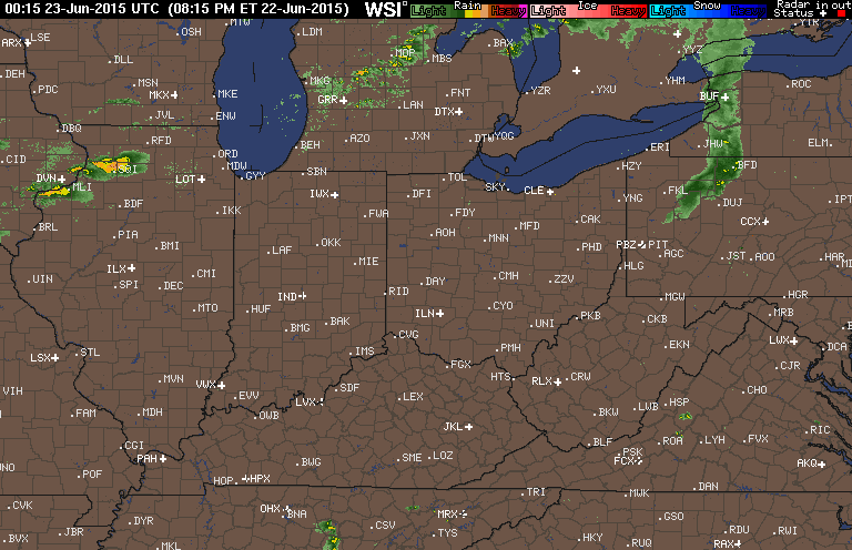
the warm front moved through late this afternoon or early this evening. it help fire up the remnants of the midwest MCS that wreaked havoc over MN, IL, and WI.
behind the warm front, our temps have increased this evening with the stronger s-sw winds. our dew points are now in the low 70s at 8:00 p.m. wow.
TOL: Jun 22, 2015 7:52 pm
Weather : A Few Clouds
Temperature : 84 F
Humidity : 65%
Wind Speed : SSW 17 mph - Gust 25 mph
Barometer : 29.80 in
Dewpoint: 71 F
Visibility : 10.00 statute miles
Heat Index : 89 F
(formerly Metcalf Airport)
Jun 22, 2015 7:53 pm
Weather : A Few Clouds and Breezy
Temperature : 85 F
Humidity : 63%
Wind Speed : SSW 23 mph - Gust 32 mph
Barometer : 29.82 in
Dewpoint: 71 F
Visibility : 10.00 statute miles
Heat Index : 90 F
(near Lambertville)
Jun 22, 2015 7:55 pm
Weather : Fair
Temperature : 85 F
Humidity : 67%
Wind Speed : SSW 9 mph
Barometer : 29.80 in
Dewpoint: 73 F
Visibility : 10.00 statute miles
Heat Index : 92 F
The warm front moved through our area late this afternoon or early this evening. Behind the front, our wind speeds have increased to 15 to 30 mph from the south-southwest, causing our temps to rise a few degrees this evening.
At 8:00 p.m., Toledo area temps were in the mid 80s with dew point temps in the low 70s. Conditions are certainly ripe at the low levels.
A line of thundershowers formed recently in central lower Michigan, and this line is dropping southeastward. We could get some rain from this, but I don't think this is the main weather system for late tonight.
I think that the severe thunderstorms currently over Wisconsin will also drop southeastward, and this could be our main weather issue after Midnight.
Strong storms currently exist in Illinois and Iowa, moving eastward. I'm unsure what their role will be in our weather.
Tornado warned counties currently exist in Wisconsin and Illinois.

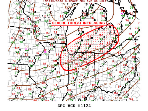
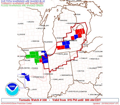
md 1124 concerning severe potential...tornado watch likely for srn lower mi...nwrn oh...nrn indiana...nern il
mesoscale discussion 1124
nws storm prediction center norman ok
0731 pm cdt mon jun 22 2015
areas affected...srn lower mi...nwrn oh...nrn indiana...nern il
concerning...severe potential...tornado watch likely
valid 230031z - 230130z
probability of watch issuance...80 percent
summary...tornado watch may be required by 01z from lower mi swwd
into nern il.
discussion...large scale ascent appears to be increasing across
lower mi per expanding elevated convection that is evolving atop
boundary layer stratus. while 00z sounding at dtx is notably
capped...800mb temperature is 7c cooler at grb in closer proximity
to short-wave trough. cooling profiles across this region should
contribute to weaker inhibition over the next few hours and elevated
convection is expected to strengthen and near-sfc based tstms will
likely evolve with time...especially over srn lower mi into nrn
indiana. shear profiles strongly support deep rotating updrafts and
given the instability observed supercells should evolve.
additionally...discrete supercell over nrn il is expected to track
sewd along decayed outflow boundary to the south side of the chicago
metro area over the next few hours. this activity could spread into
nwrn indiana later this evening.
..darrow/carbin.. 06/23/2015
...please see www.spc.noaa.gov for graphic product...
attn...wfo...cle...dtx...iwx...grr...ind...lot...ilx...
lat...lon 42128801 43908330 42748214 41588379 40368769 42128801
WOUS64 KWNS 230114
WOU8
BULLETIN - IMMEDIATE BROADCAST REQUESTED
TORNADO WATCH OUTLINE UPDATE FOR WT 338
NWS STORM PREDICTION CENTER NORMAN OK
915 PM EDT MON JUN 22 2015
TORNADO WATCH 338 IS IN EFFECT UNTIL 300 AM EDT FOR THE
FOLLOWING LOCATIONS
ILC075-091-197-230700-
/O.NEW.KWNS.TO.A.0338.150623T0115Z-150623T0700Z/
IL
. ILLINOIS COUNTIES INCLUDED ARE
IROQUOIS KANKAKEE WILL
INC003-007-015-017-033-039-049-069-073-085-087-089-091-099-103-
111-113-127-131-141-149-151-157-169-171-181-183-230700-
/O.NEW.KWNS.TO.A.0338.150623T0115Z-150623T0700Z/
IN
. INDIANA COUNTIES INCLUDED ARE
ALLEN BENTON CARROLL
CASS DE KALB ELKHART
FULTON HUNTINGTON JASPER
KOSCIUSKO LAGRANGE LAKE
LA PORTE MARSHALL MIAMI
NEWTON NOBLE PORTER
PULASKI ST. JOSEPH STARKE
STEUBEN TIPPECANOE WABASH
WARREN WHITE WHITLEY
MIC005-015-017-021-023-025-027-037-045-049-057-059-063-065-067-
075-077-087-091-093-099-115-125-145-147-149-151-155-157-159-161-
163-230700-
/O.NEW.KWNS.TO.A.0338.150623T0115Z-150623T0700Z/
MI
. MICHIGAN COUNTIES INCLUDED ARE
ALLEGAN BARRY BAY
BERRIEN BRANCH CALHOUN
CASS CLINTON EATON
GENESEE GRATIOT HILLSDALE
HURON INGHAM IONIA
JACKSON KALAMAZOO LAPEER
LENAWEE LIVINGSTON MACOMB
MONROE OAKLAND SAGINAW
SANILAC SHIAWASSEE ST. CLAIR
ST. JOSEPH TUSCOLA VAN BUREN
WASHTENAW WAYNE
OHC039-051-069-125-171-230700-
/O.NEW.KWNS.TO.A.0338.150623T0115Z-150623T0700Z/
OH
. OHIO COUNTIES INCLUDED ARE
DEFIANCE FULTON HENRY
PAULDING WILLIAMS
LCZ422-423-460-LEZ444-LHZ421-422-441-442-443-462-463-464-
230700-
/O.NEW.KWNS.TO.A.0338.150623T0115Z-150623T0700Z/
CW
. ADJACENT COASTAL WATERS INCLUDED ARE
ST. CLAIR RIVER
DETROIT RIVER
LAKE ST. CLAIR OPEN LAKE (U.S. PORTION)
MICHIGAN WATERS OF LAKE ERIE FROM DETROIT RIVER TO NORTH CAPE MI
OUTER SAGINAW BAY SW OF ALABASTER TO PORT AUSTIN MI TO INNER
SAGINAW BAY
INNER SAGINAW BAY SW OF POINT AU GRES TO BAY PORT MI
PORT AUSTIN TO HARBOR BEACH MI
HARBOR BEACH TO PORT SANILAC MI
PORT SANILAC TO PORT HURON MI
LAKE HURON FROM PORT AUSTIN TO HARBOR BEACH 5NM OFF SHORE TO THE
US/CANADIAN BORDER
LAKE HURON FROM HARBOR BEACH TO PORT SANILAC 5NM OFF SHORE TO
US/CANADIAN BORDER
LAKE HURON FROM PORT SANILAC TO PORT HURON 5NM OFF SHORE TO
US/CANADIAN BORDER
ATTN...WFO...LOT...DTX...IWX...GRR...IND...
URGENT - IMMEDIATE BROADCAST REQUESTED
TORNADO WATCH NUMBER 338
NWS STORM PREDICTION CENTER NORMAN OK
915 PM EDT MON JUN 22 2015
THE NWS STORM PREDICTION CENTER HAS ISSUED A
* TORNADO WATCH FOR PORTIONS OF
NORTHEAST ILLINOIS
NORTHERN INDIANA
SOUTHERN LOWER MICHIGAN
NORTHWEST OHIO
LAKE ERIE
LAKE HURON
* EFFECTIVE THIS MONDAY NIGHT AND TUESDAY MORNING FROM 915 PM
UNTIL 300 AM EDT.
* PRIMARY THREATS INCLUDE...
A COUPLE TORNADOES POSSIBLE
SCATTERED DAMAGING WINDS AND ISOLATED SIGNIFICANT GUSTS TO 75
MPH POSSIBLE
SCATTERED LARGE HAIL AND ISOLATED VERY LARGE HAIL EVENTS TO 2
INCHES IN DIAMETER POSSIBLE
SUMMARY...THUNDERSTORMS ARE LIKELY TO INCREASE IN COVERAGE AND
INTENSITY THIS EVENING AS A STRONG UPPER JET AND COLD FRONT APPROACH
THE REGION FROM THE WEST. A WARM AND VERY MOIST AIRMASS ACROSS THE
WATCH AREA WILL FUEL ROBUST STORM UPDRAFTS AMIDST INTENSIFYING
DEEP-LAYER WIND FIELDS. THIS SHOULD SUPPORT BOTH SUPERCELL AND
FAST-MOVING LINE SEGMENTS WITH DAMAGING WINDS...LARGE HAIL...AND
POSSIBLY A COUPLE TORNADOES.
THE TORNADO WATCH AREA IS APPROXIMATELY ALONG AND 70 STATUTE
MILES NORTH AND SOUTH OF A LINE FROM 35 MILES NORTH OF MOUNT
CLEMENS MICHIGAN TO 45 MILES NORTH OF CHAMPAIGN ILLINOIS. FOR A
COMPLETE DEPICTION OF THE WATCH SEE THE ASSOCIATED WATCH OUTLINE
UPDATE (WOUS64 KWNS WOU8).
PRECAUTIONARY/PREPAREDNESS ACTIONS...
REMEMBER...A TORNADO WATCH MEANS CONDITIONS ARE FAVORABLE FOR
TORNADOES AND SEVERE THUNDERSTORMS IN AND CLOSE TO THE WATCH
AREA. PERSONS IN THESE AREAS SHOULD BE ON THE LOOKOUT FOR
THREATENING WEATHER CONDITIONS AND LISTEN FOR LATER STATEMENTS
AND POSSIBLE WARNINGS.
&&
OTHER WATCH INFORMATION...CONTINUE...WW 335...WW 336...WW 337...
AVIATION...TORNADOES AND A FEW SEVERE THUNDERSTORMS WITH HAIL
SURFACE AND ALOFT TO 2 INCHES. EXTREME TURBULENCE AND SURFACE
WIND GUSTS TO 65 KNOTS. A FEW CUMULONIMBI WITH MAXIMUM TOPS TO
500. MEAN STORM MOTION VECTOR 27035.
The SPC issued a mesoscale discussion at 8:31 p.m. EDT, followed by a tornado watch at 9:15 p.m. that includes part of the Toledo area. The tornado watch is in effect until 3:00 a.m.
mesoscale discussion:
tornado watch
From the SPC, the primary threats within the tornado watch box include:
- a couple tornadoes possible
- scattered damaging winds and isolated significant gusts to 75 mph possible
- scattered large hail and isolated very large hail events to 2 inches in diameter possible
More from the tornado watch summary:
thunderstorms are likely to increase in coverage and intensity this evening as a strong upper jet and cold front approach the region from the west.a warm and very moist airmass across the watch area will fuel robust storm updrafts amidst intensifying deep-layer wind fields.
this should support both supercell and fast-moving line segments with damaging winds...large hail...and possibly a couple tornadoes.
Tornado Warning
Statement as of 9:44 PM EDT on June 22, 2015
The National Weather Service in Detroit/Pontiac has issued a
- Tornado Warning for...
southeastern Saginaw County in southeastern Michigan...
southwestern Tuscola County in southeastern Michigan...
- until 1030 PM EDT
- at 944 PM EDT... a severe thunderstorm capable of producing a
tornado was located near Birch Run... moving east at 40 mph.
Hazard... tornado and quarter size hail.
Source... radar indicated rotation.
Impact... flying debris will be dangerous to those caught without
shelter. Mobile homes will be damaged or destroyed.
Damage to roofs... windows and vehicles will occur. Tree
damage is likely.
- This dangerous storm will be near...
Frankenmuth and Birch Run around 955 PM EDT.
Millington around 1010 PM EDT.
Otter Lake around 1020 PM EDT.
Other locations impacted by this tornadic thunderstorm include
Burt... Fostoria and Fosters.
Precautionary/preparedness actions...
Take cover now! Move to a basement or an interior room on the lowest
floor of a sturdy building. Avoid windows. If you are outdoors... in a
Mobile home... or in a vehicle... move to the closest substantial
shelter and protect yourself from flying debris.
Lat... Lon 4333 8398 4332 8335 4324 8335 4323 8346
4322 8346 4322 8393 4326 8400
time... Mot... loc 0144z 284deg 35kt 4328 8390
Tornado... radar indicated
hail... 1.00in
Mann
Tornado Warning
Statement as of 8:47 PM CDT on June 22, 2015
... A Tornado Warning remains in effect until 915 PM CDT for northern
La Salle County...
at 847 PM CDT... a confirmed tornado was located 7 miles west of
Serena... moving east at 35 mph.
Hazard... damaging tornado.
Source... weather spotters confirmed tornado.
Impact... flying debris will be dangerous to those caught without
shelter. Mobile homes will be damaged or destroyed. Damage
to roofs... windows and vehicles will occur. Tree damage is
likely.
This tornado will be near...
Ottawa around 855 PM CDT.
Serena around 900 PM CDT.
Marseilles around 905 PM CDT.
Including the following Interstate...
I-80 between mile markers 85 and 97.
Precautionary/preparedness actions...
To repeat... a tornado is on the ground. Take cover now! Move to a
basement or an interior room on the lowest floor of a sturdy
building. Avoid windows. If you are outdoors... in a Mobile home... or
in a vehicle... move to the closest substantial shelter and protect
yourself from flying debris.
Heavy rainfall may hide this tornado. Do not wait to see or hear the
tornado. Take cover now.
Tornadoes are extremely difficult to see and confirm at night. Do not
wait to see or hear the tornado. Take cover now.
Lat... Lon 4140 8905 4158 8894 4156 8861 4130 8874
time... Mot... loc 0147z 291deg 31kt 4147 8888
Tornado... observed
hail... <.75in
Rodriguez
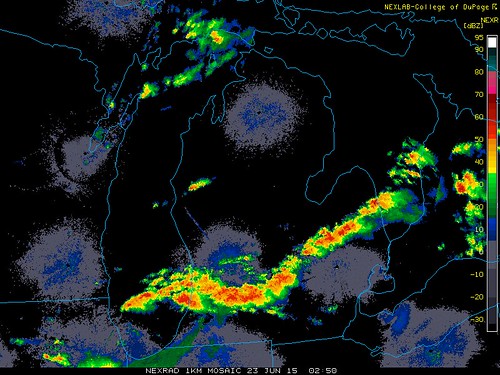
Watch boxes as of 9:42 p.m. EDT.
red = tornado watch
blue = severe thunderstorm watch
9:40 p.m. radar snapshot.
Some areas in the Michigan thumb were under either a severe thunderstorm warning or a tornado warning.
The storm in Illinois caused a tornado warning. Weather spotters confirmed a tornado on the ground at 9:47 p.m. EDT.
fxus61 kcle 230118
afdcle
area forecast discussion
national weather service cleveland oh
918 pm edt mon jun 22 2015
synopsis...
low pressure will cross the northern great lakes tonight. the
associated cold front will drop across the area late tonight and
tuesday morning. high pressure will slide across the great lakes
tuesday into wednesday. a warm front with a wave of low pressure
will move east across the area on thursday.
&&
near term /until 6 am tuesday morning/...
watch 334 has been cancelled but a severe weather threat continues
for the overnight hours as the below mentioned cold front sinks
south towards the area. despite a strong cap observed on the 00z
dtx sounding near 800mb...storms have started to develop in an
area of low level convergence across central lower michigan. moderate
instability with ml capes of 1500-2000 j/kg remains draped across
se michigan and nrn ohio. forcing for ascent is expected to
increase this evening as the shortwave trough over the upper
midwest continues eastward. a new tornado watch is being issued
for nrn indiana/southern lower michigan where shear profiles are
strong with a good likelihood for discrete cells during the late
part of the evening. with time the severe weather threat will
likely transition towards clusters or line segmets later tonight
as the activity approaches nw ohio. uncertainty remains with
exactly how the convection will evolve...if it will tend to move
east out of michigan into canada ahead of the front or build to
the se into ohio. this will likely be the difference between the
greatest threat being across ne ohio/nw pa or pushing south into
nw ohio. a watch remains possible during the overnight hours with
strong winds being the primary threat. however...tornadoes will
also be possible given the rich low level moisture and strong
shear but expect the tornado threat to diminish as we push past 2
am.
previous discussion...impressive low and mid level jet dynamics
with a lot of instability building across the midwest and getting
funneled ahead of the approaching cold front. low level shear is
progged to increase as well. all of these parameters will
eventually be directed across northwest ohio and western lake erie
tonight... and then eastward. the other ongoing thunderstorms will
have a great deal of influence on the local area. the best chance
of strong storms would seem to be ahead of the front later tonight
but thunderstorms are possible earlier on the existing outflow
boundaries of the mcv and the increasing low/mid level jet. all
thunderstorms will bring a threat for damaging winds.
thunderstorms will move relatively quickly tonight and rainfall
amounts would seem limited with each storm. any flood threat will
have to develop with training storms or repeat storms. no plans
for a flash flood watch at this time.
cannot bring myself to go as warm as the guidance for lows
tonight...at least in the areas where will see rain/thunderstorms.
pretty hard to keep low temps in the mid 70s if it rains and we get
outflow thunderstorm winds. will forecast 70/lower 70s.
&&
short term /6 am tuesday morning through thursday night/...
the front should be dropping across the forecast area tuesday
morning. some residual thunder possible as capes are progged to
remain relatively high for that time of the morning. all signs
point to the front being south of the forecast area before
thunderstorms regenerate for the tuesday event. cooler and less
humid...dewpoints will drop steadily through the day.
a weak short wave is progged to zip by on tuesday night at the same
time the surface high is building in. with the dry and stable air in
place will not mention any showers. high pressure is progged to be
overhead on wednesday. high clouds may begin to increase from the
west wednesday afternoon but will keep the forecast dry. highs near
normal. a lake breeze will develop off lake erie.
here we go again on thursday. the boundary begins to move back
north. the models have low pressure of various strengths and
locations. will continue to mention of chance of showers.storms
returning to northwest ohio later wednesday night and across the
entire forecast area on thursday. temperatures are tricky depending
on the warm front. could get pretty warm if the warm front pushes
north of the area or stay cool if we get clouds and showers and the
front remains to the south. will split the difference.
&&
long term /friday through monday/...
the pattern will be much more amplified for the weekend...digging
a deep trough across the eastern half of the u.s. that gives us
slower moving systems and below normal temperatures. biggest
change made to the weekend was to shave several degrees off of
forecast highs...placing them more in the lower/mid 70s saturday
and lower 70s sunday. a surface trough will tend to linger across
eastern oh/western pa saturday before the main upper trough axis
passes sunday. therefore lingered some lower precip chances
through saturday and kept sunday dry. the kicker upstream is
fairly well agreed upon and is progged to take a cold front across
the lower lakes late monday. it will be closer to normals monday
with the southerly flow ahead of that next system.
&&
aviation /00z tuesday through saturday/...
first round of storms has cleared the area. another round of
storms is strengthening across nw il. expect these storms to
spread east towards ohio...arriving in the tol area between
05 and 06z...then continuing off to the east. there is much
uncertainty yet how these storms will evolve...but overall
conditions are quite favorable for strong thunderstorms
overnight. cold front will move through around 23/12z and
conditions will improve to vfr through the morning as cigs
lift.
outlook...non vfr likely thursday in showers and
thunderstorms...lingering into friday.
&&
marine...
strong thunderstorms are expected for the evening and
overnight hours on the lake. some of these storms could have
significant wind associated with them. outside of thunderstorms sw
winds will steadily increase through the evening and night. with all
of this considered have added a small craft advisory to the west
half of the lake in addition to starting it now versus 2 am. the
cold front crosses tuesday morning...with wnw winds
behind...diminishing as the day goes on. high pressure and a calmer
lake are expected for wednesday. low pressure will move across nrn
oh/lake erie on thursday evening...its path determining the winds on
the lake. for now have easterly winds developing on
thursday...veering northeasterly thursday night and friday as the
low tracks east of the lake. depending on the details of this system
it could make for a choppy western third of the lake thu/fri. high
pressure will remain off to the west for saturday.
&&
cle watches/warnings/advisories...
oh...none.
pa...none.
marine...small craft advisory until 2 pm edt tuesday for lez142>149.
&&
$$
synopsis...kosarik
near term...kec/kosarik
short term...kosarik
long term...oudeman
aviation...mayers
marine...oudeman
Tornado Warning
Statement as of 10:16 PM EDT on June 22, 2015
The National Weather Service in Detroit/Pontiac has issued a
- Tornado Warning for...
northern Sanilac County in southeastern Michigan...
- until 1100 PM EDT
- at 1015 PM EDT... a severe thunderstorm capable of producing a
tornado was located near Argyle... or 9 miles southeast of Cass
City... moving east at 35 mph.
A second possible tornadic storm was also located northeast of
Argyle.
Hazard... tornado.
Source... radar indicated rotation.
Impact... flying debris will be dangerous to those caught without
shelter. Mobile homes will be damaged or destroyed.
Damage to roofs... windows and vehicles will occur. Tree
damage is likely.
- This dangerous storm will be near...
Argyle around 1020 PM EDT.
Sandusky around 1030 PM EDT.
Deckerville around 1035 PM EDT.
Carsonville around 1045 PM EDT.
Port Sanilac around 1055 PM EDT.
Other locations impacted by this tornadic thunderstorm include
Elmer... Richmondville... Decker... Palms... Snover... McGregor and
Minden.
Precautionary/preparedness actions...
Take cover now! Move to a basement or an interior room on the lowest
floor of a sturdy building. Avoid windows. If you are outdoors... in a
Mobile home... or in a vehicle... move to the closest substantial
shelter and protect yourself from flying debris.
Lat... Lon 4337 8254 4344 8311 4362 8311 4369 8261
4354 8259 4343 8254
time... Mot... loc 0215z 269deg 30kt 4353 8301
Tornado... radar indicated
hail... <.75in
Excerpts from the 9:18 a.m. Cle AFD
a new tornado watch [has been] issued for nrn indiana/southern lower michigan where shear profiles are strong with a good likelihood for discrete cells during the late part of the evening.with time the severe weather threat will likely transition towards clusters or line segmets later tonight as the activity approaches nw ohio.
uncertainty remains with exactly how the convection will evolve... if it will tend to move east out of michigan into canada ahead of the front or build to the se into ohio.
this will likely be the difference between the greatest threat being across ne ohio/nw pa or pushing south into nw ohio.
Apparently, a small chance exists that the severe weather will miss Toledo tonight.
Excerpts from the 9:18 a.m. Cle AFD
a new tornado watch [has been] issued for nrn indiana/southern lower michigan where shear profiles are strong with a good likelihood for discrete cells during the late part of the evening.with time the severe weather threat will likely transition towards clusters or line segmets later tonight as the activity approaches nw ohio.
uncertainty remains with exactly how the convection will evolve... if it will tend to move east out of michigan into canada ahead of the front or build to the se into ohio.
this will likely be the difference between the greatest threat being across ne ohio/nw pa or pushing south into nw ohio.
As of 10:25 p.m., the Michigan line of storms was moving east. Unless the line fills in some more, these storms could stay north of Toledo.
The IL storm was moving southeast. Even if it holds together until it reaches Ohio, it will probably move south of Toledo.
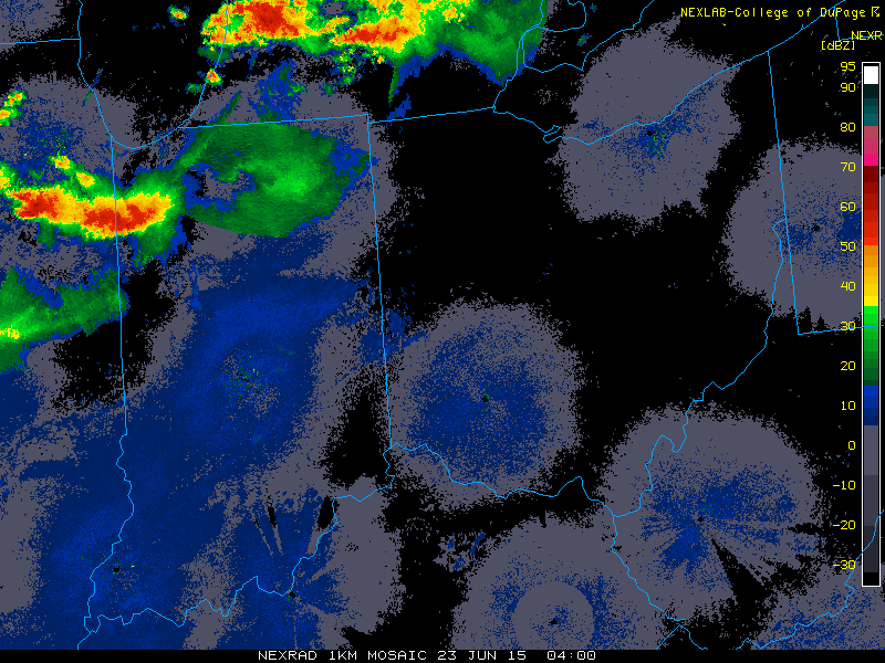
This loop ending at 10:15 p.m. shows the possibility that the heavy stuff may stay north and south of Toledo, but barely, so keep the weather radio set to alarm mode, just in case. Toledo could be book-ended by severe weather.
If activity develops along border, then that could impact Toledo. And I suppose that it's possible for the west-east line of storms located in southwest Michigan to drift southeast later tonight and reach the Toledo area.
It's definitely rough in Michigan tonight. This 10:47 p.m. warnings map shows the counties that are at least partially under a warning.
10:50 p.m. radar snapshot. For Toledo, I'm guessing that our main concern could be the storms in southwest Michigan, and whether the storms continue to move east or drift southeast.
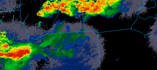
md 1128 concerning tornado watch 338... for nern il...nrn indiana...nwrn oh...sern lower mi
mesoscale discussion 1128
nws storm prediction center norman ok
1000 pm cdt mon jun 22 2015
areas affected...nern il...nrn indiana...nwrn oh...sern lower mi
concerning...tornado watch 338...
valid 230300z - 230400z
the severe weather threat for tornado watch 338 continues.
summary...severe threat continues across ww.
discussion...earlier elevated convection that evolved atop eml has
gradually intensified and by all accounts appears to have rooted
into the boundary layer. this activity is likely near-sfc based
east of lake mi from kalamazoo county...newd to the srn tip of lake
huron. several supercells have evolved along this corridor and
isolated large hail likely accompanies the strongest updrafts.
tornado threat continues with the more discrete storms.
upstream...long-lived tornadic supercell continues its sewd movement
across grundy county il and will soon move into srn will/nrn
kankakee county il over wrn portions of ww. latest rotational
velocity suggests this cyclical storm is producing a significant
tornado as it crosses i-55.
..darrow.. 06/23/2015
...please see www.spc.noaa.gov for graphic product...
attn...wfo...cle...dtx...iwx...grr...ind...lot...ilx...
lat...lon 41698823 44128282 42088282 39668827 41698823
If Toledo splits the uprights on this one, then we be living right.
Strong storms exist over southwest Michigan and especially over northeast Illinois.
11:20 p.m. radar.
Areal Flood Warning
Statement as of 11:25 PM EDT on June 22, 2015
The National Weather Service in Grand Rapids has issued a
- Flood Warning for...
southwestern Eaton County in south central Michigan...
southern Barry County in southwestern Michigan...
northern Kalamazoo County in southwestern Michigan...
northern Calhoun County in south central Michigan...
southern Allegan County in southwestern Michigan...
northern Van Buren County in southwestern Michigan...
- until 1115 am EDT Tuesday
- at 1121 PM EDT... trained spotter reports indicated flooding of
roadways is underway in northern Kalamazoo County. Flooding likely
spreads from northern Van Buren County east through Kalamazoo and
Calhoun counties with over 3 inches of rain estimated by Doppler
radar from Cooper to Gull Lake and beford. An additional 1 to 3
inches of rainfall is expected with thunderstorms over the next
few hours. M-89 is currently impassable near Richland. Expect
standing water on numerous roadways with some completely covered in
water and impassable. Driving at night on flooded roadways is
extremely dangerous. Avoid travel overnight if possible.
- Some locations that will experience flooding include...
Kalamazoo... Battle Creek... Charlotte... Albion... Marshall...
Allegan... South Haven... Plainwell... Eastwood... Westwood...
Springfield... Otsego... Galesburg... Bangor... Bellevue... Richland...
Martin... greater Galesburg... Brownlee Park and Level Park-Oak Park.
Precautionary/preparedness actions...
Be especially cautious at night when it is harder to recognize the
dangers of flooding. If flooding is observed act quickly. Move up to
higher ground to escape flood waters. Do not stay in areas subject to
flooding when water begins rising.
These southern Michigan counties were getting pounded late Monday night: Van Buren, Kalamazoo, Calhoun, Jackson, Allegan, Barry, Eaton, and Ingham
Areal Flood Warning - Statement as of 11:25 PM EDT on June 22, 2015
Flood Warning for...
southwestern Eaton County in south central Michigan...
southern Barry County in southwestern Michigan...
northern Kalamazoo County in southwestern Michigan...
northern Calhoun County in south central Michigan...
southern Allegan County in southwestern Michigan...
northern Van Buren County in southwestern Michigan
over 3 inches of rain estimated by Doppler radar from Cooper to Gull Lake and beford. An additional 1 to 3 inches of rainfall is expected with thunderstorms over the next few hours.
From JR's : articles
4316 words - 30026 chars
- 23 min read
created on
updated on
- #
source
- versions
Related articles
Severe weather threat for Sun, Nov 17, 2013 - Nov 18, 2013
Nov 17, 2013 Toledo area weather notes - Mar 03, 2014
Posts related to Nov 17, 2013 severe weather - Nov 21, 2013
Toledo area weather for early December 2013 - Dec 05, 2013
Mon, Dec 9, 2013 winter storm forecast for Sat, Dec 14 - Dec 14, 2013
more >>