Toledo weather sat jun 27 2015 - Part 2
http://jothut.com/cgi-bin/junco.pl/replies/56524
http://jothut.com/cgi-bin/junco.pl/blogpost/56513/27Jun2015/Toledo-weather-sat-jun-27-2015
Just before 4:00 p.m., Jun 27, 2015
we were out and about from approx 11:30 a.m. to 3:00 p.m. when we got home, a small-medium branch fell on our driveway apron from the silver maple tree on the devil's strip. the branch popped lose the electrical wire from our house. the bracket got pulled out from the house. dd called toledo edison. the wire is draped along our front yard and the public sidewalk. it's low over the street but cars could drive under it.
at about 4:00 p.m., a TPD officer stopped on the street to block traffic. i spoke with the officer. he said power outages exists around the city for similar things. he also said that many streets were flooded, including Douglas and The Trail. The police had to erect barricades because drivers were still attempting to drive through the water and the vehicles were stalling.
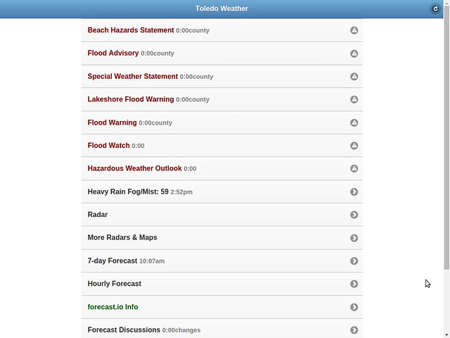
my rss feed as of 4:03 p.m.:
http://jothut.com/cgi-bin/junco.pl/blogpost/55643/22Jun2015/Nws-feeds
Toledo Weather Messages - 2015-06-27T20:06:03Z
- Flood Watch - 2015-06-27T15:46:00-04:00
- Flood Warning - 2015-06-27T15:42:00-04:00
- Flood Advisory - 2015-06-27T14:01:00-04:00
- Special Weather Statement - 2015-06-27T13:15:00-04:00
- Lakeshore Flood Warning - 2015-06-27T10:06:00-04:00
- Beach Hazards Statement - 2015-06-27T10:06:00-04:00
- Hazardous Weather Outlook - 2015-06-27T20:06:03Z
Event: Flood Watch
Alert:
...FLOOD THREAT CONTINUES INTO TONIGHT...
STEADY MODERATE TO OCCASIONALLY HEAVY RAIN WILL CONTINUE THIS
EVENING ACROSS NORTHWEST OHIO. ACROSS NORTHEAST OHIO AND NORTHWEST
PENNSYLVANIA SHOWERS AND SOME THUNDERSTORMS WILL STILL BE ABLE TO
PRODUCE HEAVY RAINFALL. AN ADDITIONAL INCH TO AN INCH AND A HALF
OF RAINFALL IS POSSIBLE. ACROSS NORTH CENTRAL OHIO RAIN WILL BE
RETURNING TO THE AREA LATER THIS EVENING. RUNOFF CONTINUES FROM
EARLIER RAINFALL.
THIS AMOUNT OF RAINFALL WILL BE EXCESSIVE AND LEAD TO FLOODING IN
SOME AREAS THROUGH TONIGHT.
...FLOOD WATCH REMAINS IN EFFECT THROUGH LATE TONIGHT...
THE FLOOD WATCH CONTINUES FOR
* PORTIONS OF OHIO AND NORTHWEST PENNSYLVANIA...INCLUDING THE
FOLLOWING AREAS...IN OHIO...ASHTABULA INLAND...ASHTABULA
LAKESHORE...CUYAHOGA...ERIE OH...GEAUGA...HANCOCK...HURON...
LAKE...LORAIN...LUCAS...MAHONING...OTTAWA...PORTAGE...
SANDUSKY...SENECA...TRUMBULL AND WOOD. IN NORTHWEST
PENNSYLVANIA...CRAWFORD PA...NORTHERN ERIE AND SOUTHERN ERIE.
* THROUGH LATE TONIGHT.
* A SLOW MOVING LOW PRESSURE SYSTEM WILL REMAIN ACROSS THE AREA
TONIGHT...SLOWLY EXITING TO THE EAST ON SUNDAY. STEADY RAINFALL
IS EXPECTED IN NORTHWEST OHIO WITH PERIODS OF SHOWERS AND
THUNDERSTORMS IN NORTH CENTRAL AND NORTHEAST OHIO AND NORTHWEST
PENNSYLVANIA. WIDESPREAD RAINFALL OF 2.0 TO 3.0 INCHES OF RAIN
WILL HAVE FALLEN FROM LAST NIGHT THROUGH LATE TONIGHT. LOCALLY
HIGHER AMOUNTS ARE POSSIBLE. GIVEN THE RECENT WET CONDITIONS...
FLOODING WILL LIKELY DEVELOP IN SOME AREAS.
* FLOODING...ESPECIALLY IN URBAN AREAS...CAN OCCUR VERY
QUICKLY...PRIMARILY AT UNDERPASSES AND POOR DRAINAGE AREAS.
RISES ON AREA CREEKS AND STREAMS WILL OCCUR AND MAY BE RUNNING
AT HIGH CAPACITY FROM THE HEAVY RAINFALL.
Instructions: A FLOOD WATCH MEANS THERE IS A POTENTIAL FOR FLOODING BASED ON CURRENT FORECASTS. YOU SHOULD MONITOR LATER FORECASTS AND BE ALERT FOR POSSIBLE FLOOD WARNINGS. THOSE LIVING IN AREAS PRONE TO FLOODING SHOULD BE PREPARED TO TAKE ACTION SHOULD FLOODING DEVELOP. STAY TUNED TO WEATHER RADIO FOR FURTHER DETAILS OR UPDATES
:
THE NATIONAL WEATHER SERVICE IN CLEVELAND HAS ISSUED A
* FLOOD WARNING FOR URBAN AREAS AND SMALL STREAMS IN...
WOOD COUNTY IN NORTHWESTERN OHIO...
LUCAS COUNTY IN NORTHWESTERN OHIO...
* UNTIL 345 PM EDT SUNDAY
* AT 339 PM EDT...DOPPLER RADAR INDICATED HEAVY RAIN THAT WILL CAUSE
FLOODING. TWO TO THREE INCHES OF RAIN HAS FALLEN OVER MUCH OF THE
AREA SINCE YESTERDAY EVENING. ANOTHER INCH OF RAIN IS LIKELY FOR
MANY AREAS THROUGH TONIGHT.
* SOME LOCATIONS THAT WILL EXPERIENCE FLOODING INCLUDE...
BOWLING GREEN...FOSTORIA...PERRYSBURG...OREGON...SYLVANIA...
ROSSFORD...WATERVILLE...NORTHWOOD...WHITEHOUSE...NORTH BALTIMORE...
HOLLAND...WESTON...MAUMEE...OTTAWA HILLS...WALBRIDGE...
PEMBERVILLE...MILLBURY...HASKINS...LUCKEY AND BRADNER.
Instructions: EXCESSIVE RUNOFF FROM HEAVY RAINFALL WILL CAUSE FLOODING OF SMALL CREEKS AND STREAMS...HIGHWAYS AND UNDERPASSES IN URBAN AREAS. ADDITIONALLY...COUNTRY ROADS AND FARMLANDS ALONG THE BANKS OF CREEKS...STREAMS AND OTHER LOW LYING AREAS ARE SUBJECT TO FLOODING.
THE NATIONAL WEATHER SERVICE IN CLEVELAND HAS ISSUED A
* FLOOD ADVISORY FOR...
WOOD COUNTY IN NORTHWESTERN OHIO...
SANDUSKY COUNTY IN NORTHWESTERN OHIO...
LUCAS COUNTY IN NORTHWESTERN OHIO...
OTTAWA COUNTY IN NORTHWESTERN OHIO...
* UNTIL MIDNIGHT EDT SUNDAY
* AT 158 PM EDT...DOPPLER RADAR INDICATED HEAVY RAINFALL FROM
SHOWERS THAT HAVE BEEN OCCURRING SINCE LAST NIGHT. RAINFALL
AMOUNTS OF 1 TO 2 INCHES HAVE BEEN COMMON. THE CONTINUED SHOWERS
HAVE CAUSED LOW LYING AREAS TO FLOOD.
* SOME LOCATIONS THAT WILL EXPERIENCE FLOODING INCLUDE...
BOWLING GREEN...FREMONT...FOSTORIA...PORT CLINTON...PERRYSBURG...
OREGON...SYLVANIA...BELLEVUE...CLYDE...ROSSFORD...WATERVILLE...
NORTHWOOD...WHITEHOUSE...NORTH BALTIMORE...OAK HARBOR...
GIBSONBURG...GENOA...WOODVILLE...HOLLAND AND WESTON.
Instructions: MOST FLOOD DEATHS OCCUR IN AUTOMOBILES. NEVER DRIVE YOUR VEHICLE INTO AREAS WHERE THE WATER COVERS THE ROADWAY. FLOOD WATERS ARE USUALLY DEEPER THAN THEY APPEAR. JUST ONE FOOT OF FLOWING WATER IS POWERFUL ENOUGH TO SWEEP VEHICLES OFF THE ROAD. WHEN ENCOUNTERING FLOODED ROADS MAKE THE SMART CHOICE...TURN AROUND...DONT DROWN. EXCESSIVE RUNOFF FROM HEAVY RAINFALL WILL CAUSE PONDING OF WATER IN URBAN AREAS...HIGHWAYS...STREETS AND UNDERPASSES AS WELL AS OTHER POOR DRAINAGE AREAS AND LOW LYING SPOTS. DO NOT ATTEMPT TO TRAVEL ACROSS FLOODED ROADS. FIND ALTERNATE ROUTES.
Event: Special Weather Statement
Alert:
...GUSTY WINDS WILL AFFECT LUCAS...WOOD...OTTAWA...SANDUSKY...AND
ERIE COUNTIES THROUGH THIS AFTERNOON...
GUSTY NORTHEAST WINDS WILL CONTINUE THIS AFTERNOON. WHILE GUSTS TO
40 MPH WILL BE MOST COMMON...GUSTS TO 50 MPH WILL BE POSSIBLE.
THERE HAVE BEEN A FEW REPORTS OF TREES AND LIMBS DOWN IN THE
AREA DUE TO THE STRONG WINDS.
Event: Lakeshore Flood Warning
Alert:
...LAKESHORE FLOOD WARNING REMAINS IN EFFECT UNTIL 10 PM EDT THIS
EVENING...
...BEACH HAZARDS STATEMENT REMAINS IN EFFECT THROUGH SUNDAY
MORNING...
* LAKE SHORE FLOODING...STRONG NORTHEAST WINDS OF 35 TO 40 KNOTS
CONTINUE THROUGH THE EVENING.
* HAZARDS...COASTAL FLOODING AND DANGEROUS SWIMMING CONDITIONS.
* TIMING...DANGEROUS SWIMMING CONDITIONS WILL OCCUR THROUGH SUNDAY
MORNING. THE COASTAL FLOODING HAS BEEN MAINLY BEEN LOCATED ALONG
THE OTTAWA AND LUCAS COUNTY SHORELINES. THE FLOODING THREAT FROM
THE LAKE SHOULD DECREASE AS WINDS SHIFT TO THE NORTH AND
NORTHWEST THIS EVENING.
* LOCATION...THE LAKESHORE FROM FROM LUCAS COUNTY TO ERIE COUNTY
OHIO
* IMPACTS...LARGE WAVES WILL CAUSE RIP CURRENTS TO DEVELOP.
RISING WATER LEVELS DUE TO DRIVING WINDS MAY RESULT FLOODING
ALONG THE LAKESHORE.
Instructions: A LAKESHORE FLOOD WARNING MEANS LAKESHORE FLOODING IS OCCURRING... IS IMMINENT... OR IS EXPECTED TO OCCUR WITHIN THE NEXT 12 HOURS. PEOPLE IN THE WARNING AREA SHOULD TAKE IMMEDIATE ACTION TO PROTECT LIFE AND PROPERTY. LISTEN TO LOCAL RADIO...TELEVISION... OR NOAA WEATHER RADIO FOR FURTHER INFORMATION. SWIMMING RISK EXISTS TODAY. THE COMBINATION OF WIND AND OR WAVES WILL MAKE FOR POTENTIALLY DANGEROUS CONDITIONS FOR SWIMMERS INCLUDING THE RISK OF RIP CURRENTS. FOLLOW THE INSTRUCTION OF LOCAL AUTHORITIES OR STAY OUT OF THE WATER.
Event: Beach Hazards Statement
Alert:
...LAKESHORE FLOOD WARNING REMAINS IN EFFECT UNTIL 10 PM EDT THIS
EVENING...
...BEACH HAZARDS STATEMENT REMAINS IN EFFECT THROUGH SUNDAY
MORNING...
* LAKE SHORE FLOODING...STRONG NORTHEAST WINDS OF 35 TO 40 KNOTS
CONTINUE THROUGH THE EVENING.
* HAZARDS...COASTAL FLOODING AND DANGEROUS SWIMMING CONDITIONS.
* TIMING...DANGEROUS SWIMMING CONDITIONS WILL OCCUR THROUGH SUNDAY
MORNING. THE COASTAL FLOODING HAS BEEN MAINLY BEEN LOCATED ALONG
THE OTTAWA AND LUCAS COUNTY SHORELINES. THE FLOODING THREAT FROM
THE LAKE SHOULD DECREASE AS WINDS SHIFT TO THE NORTH AND
NORTHWEST THIS EVENING.
* LOCATION...THE LAKESHORE FROM FROM LUCAS COUNTY TO ERIE COUNTY
OHIO
* IMPACTS...LARGE WAVES WILL CAUSE RIP CURRENTS TO DEVELOP.
RISING WATER LEVELS DUE TO DRIVING WINDS MAY RESULT FLOODING
ALONG THE LAKESHORE.
Instructions: A LAKESHORE FLOOD WARNING MEANS LAKESHORE FLOODING IS OCCURRING... IS IMMINENT... OR IS EXPECTED TO OCCUR WITHIN THE NEXT 12 HOURS. PEOPLE IN THE WARNING AREA SHOULD TAKE IMMEDIATE ACTION TO PROTECT LIFE AND PROPERTY. LISTEN TO LOCAL RADIO...TELEVISION... OR NOAA WEATHER RADIO FOR FURTHER INFORMATION. SWIMMING RISK EXISTS TODAY. THE COMBINATION OF WIND AND OR WAVES WILL MAKE FOR POTENTIALLY DANGEROUS CONDITIONS FOR SWIMMERS INCLUDING THE RISK OF RIP CURRENTS. FOLLOW THE INSTRUCTION OF LOCAL AUTHORITIES OR STAY OUT OF THE WATER.
Hazardous Weather Outlook
HAZARDOUS WEATHER OUTLOOK
NATIONAL WEATHER SERVICE CLEVELAND OH
406 PM EDT SAT JUN 27 2015
OHZ003-007-009-282015-
LUCAS-OTTAWA-ERIE OH-
406 PM EDT SAT JUN 27 2015
...LAKESHORE FLOOD WARNING IN EFFECT UNTIL 10 PM EDT THIS EVENING...
...FLOOD WATCH IN EFFECT UNTIL 4 AM EDT SUNDAY...
...BEACH HAZARDS STATEMENT IN EFFECT FROM 10 PM EDT THIS EVENING
THROUGH SUNDAY MORNING...
THIS HAZARDOUS WEATHER OUTLOOK IS FOR NORTH CENTRAL OHIO AND
NORTHWEST OHIO.
.DAY ONE...TONIGHT.
PLEASE LISTEN TO NOAA WEATHER RADIO OR GO TO WEATHER.GOV ON THE
INTERNET FOR MORE INFORMATION ABOUT THE FOLLOWING HAZARDS.
LAKESHORE FLOOD WARNING.
FLOOD WATCH.
BEACH HAZARDS STATEMENT.
.DAYS TWO THROUGH SEVEN...SUNDAY THROUGH FRIDAY.
PLEASE LISTEN TO NOAA WEATHER RADIO OR GO TO WEATHER.GOV ON THE
INTERNET FOR MORE INFORMATION ABOUT THE FOLLOWING HAZARDS.
BEACH HAZARDS STATEMENT.
.SPOTTER INFORMATION STATEMENT...
REPORTS OF RAINFALL OR FLOODING ARE APPRECIATED.
$$
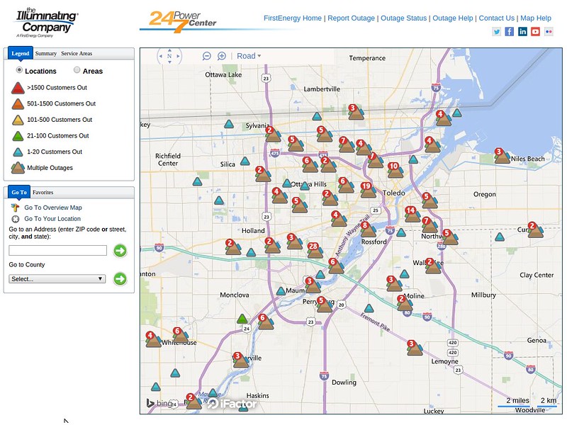
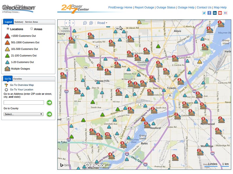
outage map as of 4:27 p.m.
lakeshore hazard message
national weather service cleveland oh
411 pm edt sat jun 27 2015
ohz003-007-009-280415-
/o.con.kcle.ls.w.0001.000000t0000z-150628t0200z/
/o.con.kcle.bh.s.0004.000000t0000z-150628t1300z/
lucas-ottawa-erie oh-
411 pm edt sat jun 27 2015
...lakeshore flood warning remains in effect until 10 pm edt this
evening...
...beach hazards statement remains in effect through sunday
morning...
- lake shore flooding...strong northeast winds of 35 to 40 knots
continue through the evening.
- hazards...coastal flooding and dangerous swimming conditions.
- timing...dangerous swimming conditions will occur through sunday
morning. the coastal flooding has been mainly been located along
the ottawa and lucas county shorelines. the flooding threat from
the lake should decrease as winds shift to the north and
northwest this evening.
- location...the lakeshore from from lucas county to erie county
ohio
- impacts...large waves will cause rip currents to develop.
rising water levels due to driving winds may result flooding
along the lakeshore.
precautionary/preparedness actions...
a lakeshore flood warning means lakeshore flooding is occurring...
is imminent... or is expected to occur within the next 12 hours.
people in the warning area should take immediate action to
protect life and property. listen to local radio...television...
or noaa weather radio for further information.
swimming risk exists today. the combination of wind and or waves
will make for potentially dangerous conditions for swimmers
including the risk of rip currents. follow the instruction of
local authorities or stay out of the water.
&&
$$
lakeshore flood warning
lakeshore hazard message
national weather service cleveland oh
411 pm edt sat jun 27 2015
ohz003-007-009-280415-
/o.con.kcle.ls.w.0001.000000t0000z-150628t0200z/
/o.con.kcle.bh.s.0004.000000t0000z-150628t1300z/
lucas-ottawa-erie oh-
411 pm edt sat jun 27 2015
...lakeshore flood warning remains in effect until 10 pm edt this
evening...
...beach hazards statement remains in effect through sunday
morning...
- lake shore flooding...strong northeast winds of 35 to 40 knots
continue through the evening.
- hazards...coastal flooding and dangerous swimming conditions.
- timing...dangerous swimming conditions will occur through sunday
morning. the coastal flooding has been mainly been located along
the ottawa and lucas county shorelines. the flooding threat from
the lake should decrease as winds shift to the north and
northwest this evening.
- location...the lakeshore from from lucas county to erie county
ohio
- impacts...large waves will cause rip currents to develop.
rising water levels due to driving winds may result flooding
along the lakeshore.
precautionary/preparedness actions...
a lakeshore flood warning means lakeshore flooding is occurring...
is imminent... or is expected to occur within the next 12 hours.
people in the warning area should take immediate action to
protect life and property. listen to local radio...television...
or noaa weather radio for further information.
swimming risk exists today. the combination of wind and or waves
will make for potentially dangerous conditions for swimmers
including the risk of rip currents. follow the instruction of
local authorities or stay out of the water.
&&
$$
hazardous weather outlook
hazardous weather outlook
national weather service cleveland oh
406 pm edt sat jun 27 2015
ohz003-007-009-282015-
lucas-ottawa-erie oh-
406 pm edt sat jun 27 2015
...lakeshore flood warning in effect until 10 pm edt this evening...
...flood watch in effect until 4 am edt sunday...
...beach hazards statement in effect from 10 pm edt this evening
through sunday morning...
this hazardous weather outlook is for north central ohio and
northwest ohio.
.day one...tonight.
please listen to noaa weather radio or go to weather.gov on the
internet for more information about the following hazards.
lakeshore flood warning.
flood watch.
beach hazards statement.
.days two through seven...sunday through friday.
please listen to noaa weather radio or go to weather.gov on the
internet for more information about the following hazards.
beach hazards statement.
.spotter information statement...
reports of rainfall or flooding are appreciated.
$$
flood watch
flood watch
national weather service cleveland oh
346 pm edt sat jun 27 2015
...flood threat continues into tonight...
steady moderate to occasionally heavy rain will continue this
evening across northwest ohio. across northeast ohio and northwest
pennsylvania showers and some thunderstorms will still be able to
produce heavy rainfall. an additional inch to an inch and a half
of rainfall is possible. across north central ohio rain will be
returning to the area later this evening. runoff continues from
earlier rainfall.
this amount of rainfall will be excessive and lead to flooding in
some areas through tonight.
ohz003-006>014-017>019-022-023-033-089-paz001>003-280500-
/o.con.kcle.fa.a.0003.000000t0000z-150628t0800z/
/00000.0.er.000000t0000z.000000t0000z.000000t0000z.oo/
lucas-wood-ottawa-sandusky-erie oh-lorain-cuyahoga-lake-geauga-
ashtabula inland-hancock-seneca-huron-portage-trumbull-mahoning-
ashtabula lakeshore-northern erie-southern erie-crawford pa-
including the cities of...toledo...bowling green...port clinton...
fremont...sandusky...lorain...cleveland...mentor...chardon...
jefferson...findlay...tiffin...norwalk...ravenna...warren...
youngstown...ashtabula...erie...edinboro...meadville
346 pm edt sat jun 27 2015
...flood watch remains in effect through late tonight...
the flood watch continues for
- portions of ohio and northwest pennsylvania...including the
following areas...in ohio...ashtabula inland...ashtabula
lakeshore...cuyahoga...erie oh...geauga...hancock...huron...
lake...lorain...lucas...mahoning...ottawa...portage...
sandusky...seneca...trumbull and wood. in northwest
pennsylvania...crawford pa...northern erie and southern erie.
- through late tonight.
- a slow moving low pressure system will remain across the area
tonight...slowly exiting to the east on sunday. steady rainfall
is expected in northwest ohio with periods of showers and
thunderstorms in north central and northeast ohio and northwest
pennsylvania. widespread rainfall of 2.0 to 3.0 inches of rain
will have fallen from last night through late tonight. locally
higher amounts are possible. given the recent wet conditions...
flooding will likely develop in some areas.
- flooding...especially in urban areas...can occur very
quickly...primarily at underpasses and poor drainage areas.
rises on area creeks and streams will occur and may be running
at high capacity from the heavy rainfall.
precautionary/preparedness actions...
a flood watch means there is a potential for flooding based on
current forecasts. you should monitor later forecasts and be
alert for possible flood warnings. those living in areas prone to
flooding should be prepared to take action should flooding
develop. stay tuned to weather radio for further details or
updates
around 4:30 p.m.
Summary:
Affected Customers: 5,184
Last Updated: Jun 27, 4:37 PM
special weather statement
national weather service cleveland oh
427 pm edt sat jun 27 2015
ohz003-006>009-280200-
lucas-wood-ottawa-sandusky-erie oh-
including the cities of...toledo...bowling green...port clinton...
fremont...sandusky
427 pm edt sat jun 27 2015
...gusty winds will affect lucas...wood...ottawa...sandusky...and
erie counties through the evening...
gusty north and northeast winds will continue into the
evening. while gusts to 40 mph will be most common...gusts to 50
mph will be possible. there have been a few reports of trees and
limbs down in the area due to the strong winds.
outage summary
Affected Customers: 5,626
Last Updated: Jun 27, 5:03 PM
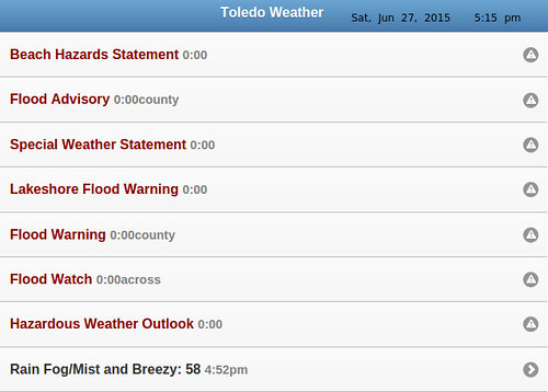
TOL:
Jun 27, 2015 4:52 pm
Weather : Rain Fog/Mist and Breezy
Temperature : 58 F
Humidity : 97%
Wind Speed : NNW 23 mph - Gust 39 mph
Barometer : 29.70 in
Dewpoint: 57 F
Visibility : 1.75 statute miles
Affected Customers: 5,458
Last Updated: Jun 27, 5:26 PM
i emptied rain gauge again. this time at 5:40 p.m. it recorded 1.50 inches. that's a total of 2.90 inches.
I think LZ provides some practical info.
- If it keeps on rainin', Levee is gonna to break
- Cryin' won't help you, prayin' won't do you no good
- When the Levee breaks, mama, you got to move
- Going to Chicago
As of 5:40 p.m., my rain gauge has recorded 2.90 inches of rainfall for the day in West Toledo.
The Toledo area may have some issues.
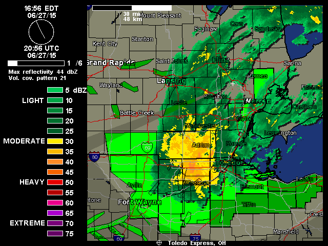
Toledo Express Airport weather at about 5:00 p.m.
Jun 27, 2015 4:52 pm
Weather : Rain Fog/Mist and Breezy
Temperature : 58 F
Humidity : 97%
Wind Speed : NNW 23 mph - Gust 39 mph
Barometer : 29.70 in
Dewpoint: 57 F
Visibility : 1.75 statute miles
Many Toledo streets were flooded and some were closed.
The heavy rain and strong winds have brought down trees and branches, causing some power outages.
Affected Customers: 5,458
Last Updated: Jun 27, 5:26 PM
Moderate-to-heavy rain should continue for a while yet. It seems to be spiraling over Toledo and moving very, very slowly. Fulton County has been getting hammered all afternoon. And it's slowly getting worse for Lucas County.
This storm makes sense in November, but in late June, that's out there. One for the books.
power outages:
Affected Customers: 6,913
Last Updated: Jun 27, 6:05 PM
around 5:40 p.m., a Toledo Edison employee stopped out in her car to survey the issue and call it in. she placed their version of caution tape across the tape in case the police officer needed to leave. it's unsure if Toledo Edison will simply attach the wire and its holding bracket back to the east side of our house, or they may shut our power off and return later to attach the wire. The latter makes less sense, since we have power. If it was a broken live wire, then yeah, shut off the power and repair when time permits. but bolting the bracket to a new spot should be simple.
Toledo Weather Messages - 2015-06-27T22:11:06Z
Flood Warning - 2015-06-27T18:02:00-04:00
Special Weather Statement - 2015-06-27T16:27:00-04:00
Lakeshore Flood Warning - 2015-06-27T16:11:00-04:00
Beach Hazards Statement - 2015-06-27T16:11:00-04:00
Flood Watch - 2015-06-27T15:46:00-04:00
Flood Warning - 2015-06-27T15:42:00-04:00
Flood Advisory - 2015-06-27T14:01:00-04:00
Hazardous Weather Outlook - 2015-06-27T22:11:06Z
Event: Flood Warning
Alert:
...The National Weather Service in Cleveland has issued a flood
warning for the following rivers in Ohio...
Maumee River At Waterville
The National Weather Service in Cleveland has issued a
* Flood warning for
the Maumee River At Waterville
* From late tonight until tuesday morning
* At 5:00 PM Saturday the stage was...8.4 feet
* Minor flooding is forecast
* Flood stage is 11.0 feet
* the river is expected to rise above flood stage around midnight tonight
and crest near 13 feet sunday evening.
* At 13.0 feet...Floodwaters can back up through storm drains onto
Water Street in Waterville making roads inaccessible.
&&
Lakeshore Flood Warning
Alert:
...LAKESHORE FLOOD WARNING REMAINS IN EFFECT UNTIL 10 PM EDT THIS
EVENING...
...BEACH HAZARDS STATEMENT REMAINS IN EFFECT THROUGH SUNDAY
MORNING...
* LAKE SHORE FLOODING...STRONG NORTHEAST WINDS OF 35 TO 40 KNOTS
CONTINUE THROUGH THE EVENING.
* HAZARDS...COASTAL FLOODING AND DANGEROUS SWIMMING CONDITIONS.
* TIMING...DANGEROUS SWIMMING CONDITIONS WILL OCCUR THROUGH SUNDAY
MORNING. THE COASTAL FLOODING HAS BEEN MAINLY BEEN LOCATED ALONG
THE OTTAWA AND LUCAS COUNTY SHORELINES. THE FLOODING THREAT FROM
THE LAKE SHOULD DECREASE AS WINDS SHIFT TO THE NORTH AND
NORTHWEST THIS EVENING.
* LOCATION...THE LAKESHORE FROM FROM LUCAS COUNTY TO ERIE COUNTY
OHIO
* IMPACTS...LARGE WAVES WILL CAUSE RIP CURRENTS TO DEVELOP.
RISING WATER LEVELS DUE TO DRIVING WINDS MAY RESULT FLOODING
ALONG THE LAKESHORE.
This is the most number of statements, advisories, watches, and warnings that I have seen in effect at the same time for Lucas County.
Toledo Area Weather Messages - 2015-06-27T22:11:06Z - (as of 6:11 p.m. EDT)
- Flood Warning - Maumee River At Waterville - 2015-06-27T18:02:00-04:00
- Special Weather Statement - 2015-06-27T16:27:00-04:00
- Lakeshore Flood Warning - 2015-06-27T16:11:00-04:00
- Beach Hazards Statement - 2015-06-27T16:11:00-04:00
- Flood Watch - 2015-06-27T15:46:00-04:00
- Flood Warning - urban areas and small streams in Lucas and Wood counties - 2015-06-27T15:42:00-04:00
- Flood Advisory - 2015-06-27T14:01:00-04:00
- Hazardous Weather Outlook - 2015-06-27T22:11:06Z
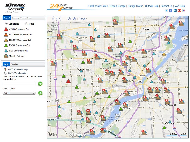
power outages
Affected Customers: 8,159
Last Updated: Jun 27, 6:29 PM
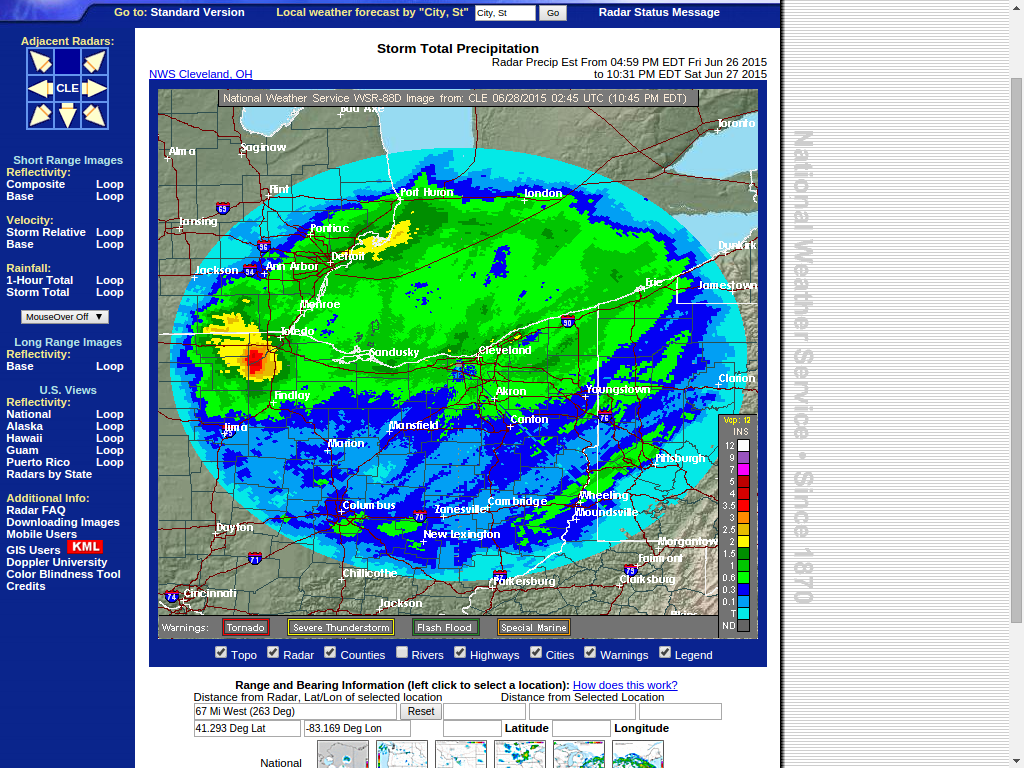
image of http://alerts.weather.gov/cap/wwaatmget.php?x=OHC095&y=1
Areal Flood Warning
Statement as of 4:16 PM EDT on June 27, 2015
The National Weather Service in northern Indiana has issued a
- Flood Warning for...
De Kalb County in northeastern Indiana...
Allen County in northeastern Indiana...
LaGrange County in northeastern Indiana...
eastern Noble County in northeastern Indiana...
Steuben County in northeastern Indiana...
St. Joseph County in southwestern Michigan...
Branch County in southwestern Michigan...
Hillsdale County in southeastern Michigan...
Paulding County in west central Ohio...
Van Wert County in west central Ohio...
Putnam County in west central Ohio...
Williams County in northwestern Ohio...
Fulton County in northwestern Ohio...
Defiance County in northwestern Ohio...
Henry County in northwestern Ohio...
northern Allen County in west central Ohio...
- until 115 am EDT Sunday
- at 411 PM EDT... Doppler radar and automated rain gauges indicated
that heavy rain with up to 4 inches of rain has fallen. That heavy
rain is causing extensive flooding.
- Some locations that will experience flooding include...
Fort Wayne... Defiance... New Haven... Auburn... Sturgis... Coldwater...
Van Wert... Kendallville... Napoleon... Angola... Bryan... Hillsdale...
Three Rivers... Wauseon... Delphos... Garrett... Ottawa... Archbold...
Bluffton... Hamler... Archbold and Montpelier.
Additional rainfall amounts of 1 to 2 inches are possible in the
warned area. The heaviest additional amounts are expected across
Fulton and northern Henry counties. In addition... wind gusts to 40
mph may lead to downed or uprooted trees... due to the extremely
saturated ground.
Precautionary/preparedness actions...
Most flood deaths occur in automobiles. Never drive your vehicle into
areas where the water covers the roadway. Flood waters are usually
deeper than they appear. Just one foot of flowing water is powerful
enough to sweep vehicles off the Road. When encountering flooded
roads make the smart choice... turn around... dont drown.
Excessive runoff from heavy rainfall will cause flooding of small
creeks and streams... highways and underpasses in urban areas.
Additionally... country roads and farmlands along the banks of
creeks... streams and other low lying areas are subject to flooding.
Move livestock to higher ground.
Do not drive your vehicle into areas where the water covers the
roadway. The water depth may be too great to allow your car to cross
safely. Move to higher ground.
Affected Customers: 8,285
Last Updated: Jun 27, 7:23 PM
http://www.toledoblade.com/local/2015/06/27/Area-road-closings.html
7:28 p.m.
http://www.dot.state.oh.us/districts/D02/newsreleases/Pages/High-Water-Update.aspx
Northwest Ohio road closings, according to the Ohio Department of Transportation:
Fulton County
U.S. 20A east of Delta
U.S. 20 near C.R. 7
Henry County:
S.R. 109 in Hamler
Ottawa County:
S.R. 19 by Toussaint Road
S.R. 2 near Thompson Road
S.R. 53 near the Miller Ferry Dock
S.R. 163 near Marblehead Park
http://www.toledoblade.com/local/2015/06/27/Anthony-Wayne-Trail-near-Hippo-Way-closed.html
Anthony Wayne Trail near Hippo Way is closed until further notice, according to a tweet posted on the City of Toledo account. Water levels are above 12 inches, and unable to be driven through.
http://toledoblade.tumblr.com/
power outages in the toledo area of northwest ohio:
Affected Customers: 7,489
Last Updated: Jun 27, 7:48 PM
flood statement
national weather service cleveland oh
759 pm edt sat jun 27 2015
ohc095-173-281945-
/o.con.kcle.fa.w.0013.000000t0000z-150628t1945z/
/00000.0.er.000000t0000z.000000t0000z.000000t0000z.oo/
wood oh-lucas oh-
759 pm edt sat jun 27 2015
...a flood warning for urban areas and small streams remains in
effect until 345 pm edt sunday for wood and lucas counties...
at 751 pm edt...doppler radar continued to indicate a large area of
moderate to locally heavy rain falling over lucas and wood counties.
radar estimates that much of the area has received 3 to 4 inches of
rainfall over the past 24 hours with half of that falling this
afternoon and evening. up to an inch of additional rainfall may
occur through midnight then the rain will start to diminish and
shift off to the east.
some roadways are flooded and now it will be getting dark
soon...extra caution will be needed to avoid driving into a flooded
area.
some locations that will experience flooding include...
bowling green...fostoria...perrysburg...oregon...sylvania...
rossford...waterville...northwood...whitehouse...north baltimore...
holland...weston...maumee...ottawa hills...walbridge...pemberville...
millbury...haskins...luckey and bradner.
precautionary/preparedness actions...
excessive runoff from heavy rainfall will cause flooding of small
creeks and streams...highways and underpasses in urban areas.
additionally...country roads and farmlands along the banks of
creeks...streams and other low lying areas are subject to flooding.
be especially cautious at night when it is harder to recognize the
dangers of flooding. if flooding is observed act quickly. move up to
higher ground to escape flood waters. do not stay in areas subject to
flooding when water begins rising.
Toledo Weather Messages - 2015-06-28T00:01:03Z
Flood Warning - 2015-06-27T19:59:00-04:00
Flood Warning - 2015-06-27T18:02:00-04:00
Special Weather Statement - 2015-06-27T16:27:00-04:00
Lakeshore Flood Warning - 2015-06-27T16:11:00-04:00
Beach Hazards Statement - 2015-06-27T16:11:00-04:00
Flood Watch - 2015-06-27T15:46:00-04:00
Flood Advisory - 2015-06-27T14:01:00-04:00
Hazardous Weather Outlook - 2015-06-28T00:01:03Z
Jun 27, 2015 7:52 pm
Weather : Rain and Breezy
Temperature : 57 F
Humidity : NA%
Wind Speed : NNW 22 mph - Gust 30 mph
Barometer : 29.73 in
Dewpoint: NA F
Visibility : 3.00 statute miles
http://outages.firstenergycorp.com/oh.html
http://radar.weather.gov/lite/N0R/IWX_loop.gif
http://radar.weather.gov/lite/N0R/DTX_loop.gif
http://radar.weather.gov/lite/N0R/CLE_loop.gif
late this afternoon:
According to the Ottawa County Amateur Radio Emergency Service, State Route 2 in Ottawa Co has been CLOSED between Ottawa National Wildlife Refuge & Port Clinton.
Northwest Ohio road closings, according to the Ohio Department of Transportation:
Lucas County:
Reynolds Rd. from 900 South Reynolds to Angola
South Detroit between Airport and South
Outbound Anthony Wayne Trail at Copland
Fulton County:
U.S. 20A east of Delta
U.S. 20 near C.R. 7
Henry County:
S.R. 109 in Hamler
Ottawa County:
S.R. 19 by Toussaint Road
S.R. 2 near Thompson Road
S.R. 53 near the Miller Ferry Dock
S.R. 163 near Marblehead Park
http://www.toledoblade.com/image/2015/06/27/800x_b1_cCM_z/wow-jpg.jpg
Toledo Weather Messages - 2015-06-28T02:31:05Z
Flood Warning - 2015-06-27T22:24:00-04:00
Lakeshore Flood Warning - 2015-06-27T21:56:00-04:00
Beach Hazards Statement - 2015-06-27T21:56:00-04:00
Flood Watch - 2015-06-27T21:41:00-04:00
Flood Warning - 2015-06-27T19:59:00-04:00
Flood Warning - 2015-06-27T18:02:00-04:00
Flood Advisory - 2015-06-27T14:01:00-04:00
Hazardous Weather Outlook - 2015-06-28T02:31:05Z
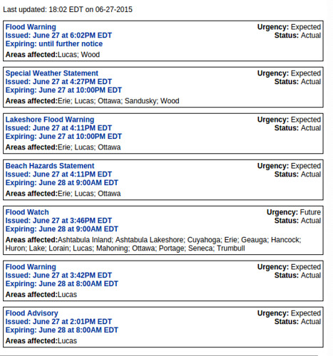
Last updated: 22:24 EDT on 06-27-2015
Flood Warning
Issued: June 27 at 10:24PM EDT
Expiring: June 29 at 6:30PM EDT Urgency: Expected
Status: Actual
Areas affected:Lucas; Wood
Lakeshore Flood Warning
Issued: June 27 at 9:56PM EDT
Expiring: June 28 at 12:00AM EDT Urgency: Expected
Status: Actual
Areas affected:Erie; Lucas; Ottawa
Beach Hazards Statement
Issued: June 27 at 9:56PM EDT
Expiring: June 28 at 9:00AM EDT Urgency: Expected
Status: Actual
Areas affected:Erie; Lucas; Ottawa
Flood Watch
Issued: June 27 at 9:41PM EDT
Expiring: June 28 at 9:00AM EDT Urgency: Future
Status: Actual
Areas affected:Ashtabula Inland; Ashtabula Lakeshore; Cuyahoga; Erie; Geauga; Hancock; Huron; Lake; Lorain; Lucas; Mahoning; Ottawa; Portage; Seneca; Trumbull
Flood Warning
Issued: June 27 at 7:59PM EDT
Expiring: June 28 at 8:00AM EDT Urgency: Expected
Status: Actual
Areas affected:Lucas
Flood Warning
Issued: June 27 at 6:02PM EDT
Expiring: until further notice Urgency: Expected
Status: Actual
Areas affected:Lucas; Wood
Flood Advisory
Issued: June 27 at 2:01PM EDT
Expiring: June 28 at 8:00AM EDT Urgency: Expected
Status: Actual
Areas affected:Lucas
lakeshore hazard message
national weather service cleveland oh
956 pm edt sat jun 27 2015
ohz003-007-009-281000-
/o.ext.kcle.ls.w.0001.000000t0000z-150628t0400z/
/o.con.kcle.bh.s.0004.000000t0000z-150628t1300z/
lucas-ottawa-erie oh-
956 pm edt sat jun 27 2015
...lakeshore flood warning now in effect until midnight edt
tonight...
...beach hazards statement remains in effect until 9 am edt
sunday...
- lake shore flooding...strong north winds of 30 to 35 knots
continue through the remainder of the evening.
- hazards...coastal flooding and dangerous swimming conditions.
- timing...dangerous swimming conditions will occur through
sunday morning. the coastal flooding has been mainly been
located along the ottawa and lucas county shorelines. the
flooding threat from the lake should decrease as winds shift
to the north and northwest this evening.
- location...the lakeshore from from lucas county to erie county
ohio
- impacts...large waves will cause rip currents to develop.
rising water levels due to driving winds may result flooding
along the lakeshore.
precautionary/preparedness actions...
a lakeshore flood warning means lakeshore flooding is occurring...
is imminent... or is expected to occur within the next 12 hours.
people in the warning area should take immediate action to
protect life and property. listen to local radio...television...
or noaa weather radio for further information.
swimming risk exists today. the combination of wind and or waves
will make for potentially dangerous conditions for swimmers
including the risk of rip currents. follow the instruction of
local authorities or stay out of the water.
&&
$$
flood warning
flood warning
national weather service cleveland oh
1024 pm edt sat jun 27 2015
...the national weather service in cleveland has issued a flood
warning for the following rivers in ohio...
maumee river near grand rapids
precautionary/preparedness actions...
never drive your car through flooded roadways. the water may be
deeper than it appears. turn around...don`t drown!
stay tuned to noaa weather radio and other local media for further
details and updates.
&&
ohc095-173-281024-
/o.new.kcle.fl.w.0058.150628t0824z-150629t2230z/
/grro1.1.er.150628t0824z.150628t1800z.150629t1030z.no/
1024 pm edt sat jun 27 2015
the national weather service in cleveland has issued a
- flood warning for
the maumee river near grand rapids - from late tonight until monday morning
- flood stage is 17.5 feet
- the river is forecast to reach flood stage around 4am sunday and
crest near 18.4 feet sunday afternoon. - at 18.5 feet...the 100 year flood level. mary jane thursten state park
campground is inundated. homes in wood county cut off from emergency
access. portions of route 24 and the metropark facilities are
inundated.
&&
lat...lon 4143 8388 4148 8376 4145 8374 4139 8388
$$
beach hazards statement
lakeshore hazard message
national weather service cleveland oh
956 pm edt sat jun 27 2015
ohz003-007-009-281000-
/o.ext.kcle.ls.w.0001.000000t0000z-150628t0400z/
/o.con.kcle.bh.s.0004.000000t0000z-150628t1300z/
lucas-ottawa-erie oh-
956 pm edt sat jun 27 2015
...lakeshore flood warning now in effect until midnight edt
tonight...
...beach hazards statement remains in effect until 9 am edt
sunday...
- lake shore flooding...strong north winds of 30 to 35 knots
continue through the remainder of the evening.
- hazards...coastal flooding and dangerous swimming conditions.
- timing...dangerous swimming conditions will occur through
sunday morning. the coastal flooding has been mainly been
located along the ottawa and lucas county shorelines. the
flooding threat from the lake should decrease as winds shift
to the north and northwest this evening.
- location...the lakeshore from from lucas county to erie county
ohio
- impacts...large waves will cause rip currents to develop.
rising water levels due to driving winds may result flooding
along the lakeshore.
precautionary/preparedness actions...
a lakeshore flood warning means lakeshore flooding is occurring...
is imminent... or is expected to occur within the next 12 hours.
people in the warning area should take immediate action to
protect life and property. listen to local radio...television...
or noaa weather radio for further information.
swimming risk exists today. the combination of wind and or waves
will make for potentially dangerous conditions for swimmers
including the risk of rip currents. follow the instruction of
local authorities or stay out of the water.
&&
$$
flood watch
flood watch
national weather service cleveland oh
941 pm edt sat jun 27 2015
...flood threat continues tonight...
ohz003-006>014-017>019-022-023-033-089-paz001>003-280800-
/o.con.kcle.fa.a.0003.000000t0000z-150628t0800z/
/00000.0.er.000000t0000z.000000t0000z.000000t0000z.oo/
lucas-wood-ottawa-sandusky-erie oh-lorain-cuyahoga-lake-geauga-
ashtabula inland-hancock-seneca-huron-portage-trumbull-mahoning-
ashtabula lakeshore-northern erie-southern erie-crawford pa-
including the cities of...toledo...bowling green...port clinton...
fremont...sandusky...lorain...cleveland...mentor...chardon...
jefferson...findlay...tiffin...norwalk...ravenna...warren...
youngstown...ashtabula...erie...edinboro...meadville
941 pm edt sat jun 27 2015
...flood watch remains in effect until 4 am edt sunday...
the flood watch continues for
- portions of ohio and northwest pennsylvania...including the
following areas...in ohio...ashtabula inland...ashtabula
lakeshore...cuyahoga...erie oh...geauga...hancock...huron...
lake...lorain...lucas...mahoning...ottawa...portage...
sandusky...seneca...trumbull and wood. in northwest
pennsylvania...crawford pa...northern erie and southern erie.
- until 4 am edt sunday
- a stalled low pressure system near cleveland will slowly drift
off to the east through sunday morning allowing the threat for
new flooding to lessen toward daybreak. widespread rainfall of
2.0 to locally 4 inches has fallen causing flooding of low-lying
areas...creeks and rivers. additional rainfall through 3 am
could reach up to an inch in some locations...especially between
interstate 75 and the port clinton and fremont ohio areas.
- flooding...as runoff from the heavy rainfall continues to make
its way into the waterways...additional rises on area
creeks...streams and rivers will occur.
precautionary/preparedness actions...
a flood watch means there is a potential for flooding based on
current forecasts. you should monitor later forecasts and be
alert for possible flood warnings. those living in areas prone to
flooding should be prepared to take action should flooding
develop. stay tuned to weather radio for further details or
updates. use caution while driving as many roadways may be flooded
ot starting to flood.
&&
$$
flood warning
flood statement
national weather service cleveland oh
759 pm edt sat jun 27 2015
ohc095-173-281945-
/o.con.kcle.fa.w.0013.000000t0000z-150628t1945z/
/00000.0.er.000000t0000z.000000t0000z.000000t0000z.oo/
wood oh-lucas oh-
759 pm edt sat jun 27 2015
...a flood warning for urban areas and small streams remains in
effect until 345 pm edt sunday for wood and lucas counties...
at 751 pm edt...doppler radar continued to indicate a large area of
moderate to locally heavy rain falling over lucas and wood counties.
radar estimates that much of the area has received 3 to 4 inches of
rainfall over the past 24 hours with half of that falling this
afternoon and evening. up to an inch of additional rainfall may
occur through midnight then the rain will start to diminish and
shift off to the east.
some roadways are flooded and now it will be getting dark
soon...extra caution will be needed to avoid driving into a flooded
area.
some locations that will experience flooding include...
bowling green...fostoria...perrysburg...oregon...sylvania...
rossford...waterville...northwood...whitehouse...north baltimore...
holland...weston...maumee...ottawa hills...walbridge...pemberville...
millbury...haskins...luckey and bradner.
precautionary/preparedness actions...
excessive runoff from heavy rainfall will cause flooding of small
creeks and streams...highways and underpasses in urban areas.
additionally...country roads and farmlands along the banks of
creeks...streams and other low lying areas are subject to flooding.
be especially cautious at night when it is harder to recognize the
dangers of flooding. if flooding is observed act quickly. move up to
higher ground to escape flood waters. do not stay in areas subject to
flooding when water begins rising.
&&
lat...lon 4172 8387 4173 8346 4173 8345 4172 8347
4169 8343 4169 8335 4171 8334 4164 8323
4163 8318 4174 8311 4162 8318 4162 8342
4117 8342 4117 8388 4118 8388
$$
adams
flood warning
flood warning
national weather service cleveland oh
602 pm edt sat jun 27 2015
...the national weather service in cleveland has issued a flood
warning for the following rivers in ohio...
maumee river at waterville
precautionary/preparedness actions...
never drive your car through flooded roadways. the water may be
deeper than it appears. turn around...don`t drown!
stay tuned to noaa weather radio and other local media for further
details and updates.
&&
ohc095-173-280602-
/o.new.kcle.fl.w.0056.150628t0418z-000000t0000z/
/wtvo1.1.er.150628t0418z.150629t0000z.000000t0000z.no/
602 pm edt sat jun 27 2015
the national weather service in cleveland has issued a
- flood warning for
the maumee river at waterville - from late tonight until tuesday morning
- at 5:00 pm saturday the stage was...8.4 feet
- minor flooding is forecast
- flood stage is 11.0 feet
- the river is expected to rise above flood stage around midnight tonight
and crest near 13 feet sunday evening. - at 13.0 feet...floodwaters can back up through storm drains onto
water street in waterville making roads inaccessible.
&&
lat...lon 4148 8376 4171 8348 4167 8345 4147 8371
4145 8374
$$
hazardous weather outlook
hazardous weather outlook
national weather service cleveland oh
406 pm edt sat jun 27 2015
ohz003-007-009-282015-
lucas-ottawa-erie oh-
406 pm edt sat jun 27 2015
...lakeshore flood warning in effect until 10 pm edt this evening...
...flood watch in effect until 4 am edt sunday...
...beach hazards statement in effect from 10 pm edt this evening
through sunday morning...
this hazardous weather outlook is for north central ohio and
northwest ohio.
.day one...tonight.
please listen to noaa weather radio or go to weather.gov on the
internet for more information about the following hazards.
lakeshore flood warning.
flood watch.
beach hazards statement.
.days two through seven...sunday through friday.
please listen to noaa weather radio or go to weather.gov on the
internet for more information about the following hazards.
beach hazards statement.
.spotter information statement...
reports of rainfall or flooding are appreciated.
$$
flood advisory
flood advisory
national weather service cleveland oh
201 pm edt sat jun 27 2015
ohc095-123-143-173-280400-
/o.new.kcle.fa.y.0035.150627t1801z-150628t0400z/
/00000.n.er.000000t0000z.000000t0000z.000000t0000z.oo/
wood oh-sandusky oh-lucas oh-ottawa oh-
201 pm edt sat jun 27 2015
the national weather service in cleveland has issued a
- flood advisory for...
wood county in northwestern ohio...
sandusky county in northwestern ohio...
lucas county in northwestern ohio...
ottawa county in northwestern ohio...
- until midnight edt sunday
- at 158 pm edt...doppler radar indicated heavy rainfall from
showers that have been occurring since last night. rainfall
amounts of 1 to 2 inches have been common. the continued showers
have caused low lying areas to flood.
- some locations that will experience flooding include...
bowling green...fremont...fostoria...port clinton...perrysburg...
oregon...sylvania...bellevue...clyde...rossford...waterville...
northwood...whitehouse...north baltimore...oak harbor...
gibsonburg...genoa...woodville...holland and weston.
precautionary/preparedness actions...
most flood deaths occur in automobiles. never drive your vehicle into
areas where the water covers the roadway. flood waters are usually
deeper than they appear. just one foot of flowing water is powerful
enough to sweep vehicles off the road. when encountering flooded
roads make the smart choice...turn around...dont drown.
excessive runoff from heavy rainfall will cause ponding of water in
urban areas...highways...streets and underpasses as well as other
poor drainage areas and low lying spots. do not attempt to travel
across flooded roads. find alternate routes.
&&
lat...lon 4172 8387 4173 8346 4173 8345 4172 8347
4169 8344 4161 8310 4151 8299 4152 8289
4159 8284 4153 8282 4151 8276 4150 8277
4149 8296 4145 8304 4142 8294 4144 8285
4125 8284 4125 8341 4117 8342 4117 8388
$$
mullen
page created: Jun 27, 2015 - 10:40 p.m. EDT
As of 10:00 p.m., 3.82 inches of rain has fallen at our home today. Most of the heavier rain has passed. We may have some light rain for a while.
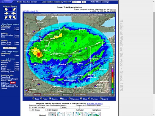
It appears that the counties of Lucas, Fulton, Wood, and Lenawee received the bulk of the rainfall from this system.
According to the radar estimate rainfall map, it appears that southwest Lucas County and northwest Wood County may have received the most rainfall.
First Energy outages map
Affected Customers: 6,961
Last Updated: Jun 27, 10:21 PM
Blade story road closings
District 2 ODOT road closings
- Lucas County:
- Reynolds Rd. from 900 South Reynolds to Angola
- South Detroit between Airport and South
- Outbound Anthony Wayne Trail at Copland
- Fulton County:
- U.S. 20A east of Delta
- U.S. 20 near C.R. 7
- Henry County:
- S.R. 109 in Hamler
- Ottawa County:
- S.R. 19 by Toussaint Road
- S.R. 2 near Thompson Road
- S.R. 53 near the Miller Ferry Dock
- S.R. 163 near Marblehead Park
Blade story
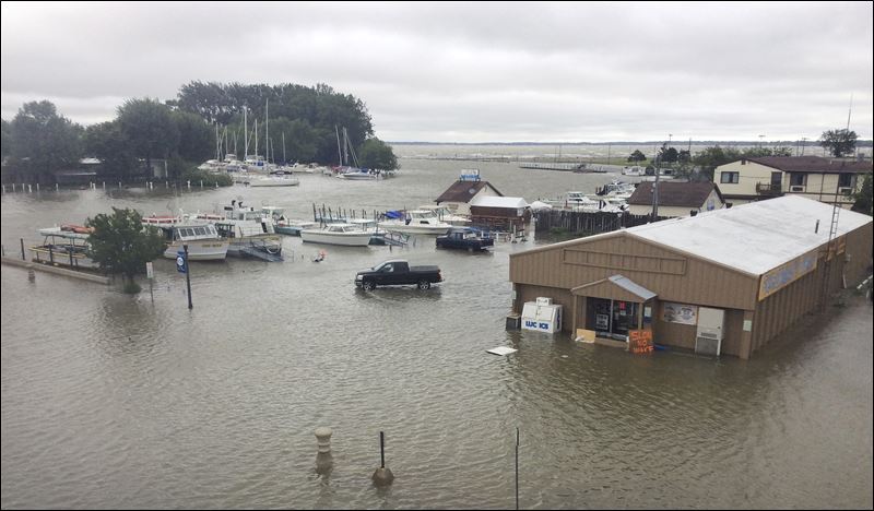
"Madison Street in downtown Port clinton is underwater Saturday afternoon."
At 10:24 p.m., the Cle NWS issued yet another flood warning. This one is for the Maumee River at Grand Rapids.
The National Weather Service in Cleveland has issued a
- Flood warning for the Maumee River Near Grand Rapids
- From late tonight until Monday morning
- Flood stage is 17.5 feet
- the river is forecast to reach flood stage around 4am sunday and crest near 18.4 feet sunday afternoon.
- At 18.5 feet ... the 100 year flood level. Mary Jane Thursten State Park Campground is inundated. Homes in Wood County cut off from emergency access. Portions of route 24 and the metropark facilities are inundated.
https://twitter.com/MILLERBOATLINE/status/614967009399439364
https://twitter.com/Ryan_Wichman/status/614966266961494016
For all those wondering...this will be the closest thing you will ever experience to a true tropical storm ever in northwest Ohio/SE MI.
https://twitter.com/RohrsBros/status/614893174423703552
https://twitter.com/Ryan_Wichman/status/614869184422506497
https://twitter.com/JaceyFaneuff/status/614870153151520768
https://twitter.com/Ryan_Wichman/status/614866582465085440
https://twitter.com/blb739/status/614864680121729024
https://twitter.com/jim_lorenzen/status/614861094348288000
On Saturday, Lake Erie tried to reclaim some of her former marsh land. It looked rough along the shoreline in Lucas and Ottawa counties.
https://twitter.com/JordanStrack/status/614948489156538368
Oregon Fire Department is giving out sandbags to help with flooding.

The gales of November came really early. On Saturday, Lake Erie tried to reclaim some of her former marsh land. It looked rough along the shoreline.
It looked rough well inland too. Multiple types of flooding.
Sat, Jun 27, 2015 info and images via https://twitter.com/ryan_wichman
https://twitter.com/Travis_Ardner/status/614838217452425216
Look out my front door right now!
Bascom, Ohio, located in Seneca County.

https://twitter.com/Ryan_Wichman/status/614979458769010689
Officially 3.44" of rain today in Toledo. Beats out the old record of 3.41" for wettest June day in Toledo history. 140+ years of records.
Some peopled tagged their posts with #TropicalStormToledo.
https://twitter.com/Ryan_Wichman/status/614966266961494016
For all those wondering...this will be the closest thing you will ever experience to a true tropical storm ever in northwest Ohio/SE MI.

Based upon of the very slow movement of Saturday's low pressure system through northern Ohio and the persistent strong wind gusts (30 to 40 mph) and heavy rains for approximately 18 hours, the above tropical storm reference probably makes sense.
But in September 2008, the remnants of Hurricane Ike blitzed through Ohio, including the Toledo area. That system caused a lot of damage in southwest Ohio. It produced strong winds and some rain in northwest Ohio, but it moved through our area super fast.
Hurricane-force wind gusts were reported to the east of the center across parts of Kentucky, Indiana, Ohio and Pennsylvania with significant wind damage including structural damage to buildings and trees.
Sep 14, 2008 Blade story about Ike remnants moving through our area.
Crews throughout northwest Ohio and southeast Michigan are cleaning up after strong winds hit the area Sunday afternoon. The remnants of Hurricane Ike, now a tropical depression, whipped through the region with wind speeds as high as 69 mph in Tiffin and 65 mph in Findlay. Gusts downed tree limbs and power lines across the area. ... most of the real heavy rain stayed to the west, but we ended up with the wind ...
Oh, the Blizzard of '78 was also called a White Hurricane, but that was snow, so it doesn't count.
Back to Sat, Jun 27.
https://twitter.com/Ryan_Wichman/status/614814732864876544
6-10 foot waves likely on Lake Erie today. Some up to 12' possible. Major swells for the shallow western basin.
https://twitter.com/Ryan_Wichman/status/614815513756192769
Wave height of 8' being reported by just offshore of Oregon, OH on Lake Erie. Extreme for western basin.
That's not unusual for the fall. It's bizarre for late June.
A gale warning for the western basin of Lake Erie generally produces forecast waves in the 5- to 10-foot range. A storm warning would produce waves over 12 feet.
Waves get larger in the central and eastern basins of Lake Erie. Here's a Lake Erie forecast from November 2013 for the central and eastern basins.
west gales to 40 knots decreasing to 35 knots. mostly cloudy with a chance of rain showers. waves 12 to 16 feet.
A Lake Erie forecast from late October 2012 that I think was for areas east of the islands.
storm warning in effect through tuesday morning... .tonight... north gales to 45 knots becoming northwest storm force winds to 50 knots. rain. waves building to 17 to 22 feet.
Jun 27, 2015 continued.
https://twitter.com/JordanStrack/status/614948489156538368
Oregon Fire Department is giving out sandbags to help with flooding.
https://twitter.com/Ryan_Wichman/status/614869184422506497
Western Lake Erie as seen from Luna Pier, MI this afternoon.

https://twitter.com/blb739/status/614864680121729024
Bayshore Rd. Marblehead

https://twitter.com/JaceyFaneuff/status/614870153151520768
Perks of living on the lake.

https://twitter.com/Ryan_Wichman/status/614853594857250817
Tree fell through a house in Oregon, OH due to strong winds this afternoon. Everyone was okay

https://twitter.com/nathansteinmetz/status/614841564066676737
tree snapped right in front of us across Louisiana in downtown Perrysburg. Missed a car by a foot.

https://twitter.com/Ryan_Wichman/status/614919731410284544
Report of 6" of rain today in Hamler, OH.
Main Street in Hamler, located in southern Henry County.

https://twitter.com/TechnoDilbert/status/614927233480826880
about a foot+ deep in front of my house on W. Northgate [Toledo]. Much deeper to the west here. 3 cars stranded.

When Lake Erie growls, some people go out and enjoy it. Can't waste good freaky weather for late June. This had to be fun, especially since the Lake Erie water temp off Toledo is 70 degrees.
https://twitter.com/jim_lorenzen/status/614840790519562240
watched these guys at Maumee Bay.


From JR's : articles
7101 words - 51980 chars
- 39 min read
created on
updated on
- #
source
- versions
Related articles
Severe weather threat for Sun, Nov 17, 2013 - Nov 18, 2013
Nov 17, 2013 Toledo area weather notes - Mar 03, 2014
Posts related to Nov 17, 2013 severe weather - Nov 21, 2013
Toledo area weather for early December 2013 - Dec 05, 2013
Mon, Dec 9, 2013 winter storm forecast for Sat, Dec 14 - Dec 14, 2013
more >>