Toledo weather Sun, Jun 28, 2015
hazardous weather outlook
national weather service cleveland oh
1149 pm edt sat jun 27 2015
ohz003-007-009>012-089-paz001-290400-
lucas-ottawa-erie oh-lorain-cuyahoga-lake-ashtabula lakeshore-
northern erie-
1149 pm edt sat jun 27 2015
...flood watch in effect until 4 am edt sunday...
...beach hazards statement in effect until 9 am edt sunday...
this hazardous weather outlook is for north central
ohio...northeast ohio...northwest ohio and northwest pennsylvania.
.day one...tonight.
please listen to noaa weather radio or go to weather.gov on the
internet for more information about the following hazards.
beach hazards statement.
flood watch.
.days two through seven...sunday through friday.
please listen to noaa weather radio or go to weather.gov on the
internet for more information about the following hazards.
beach hazards statement.
.spotter information statement...
spotter activation is not expected at this time.
$$
beach hazards statement
lakeshore hazard message
national weather service cleveland oh
1138 pm edt sat jun 27 2015
ohz003-007-009-281145-
/o.can.kcle.ls.w.0001.000000t0000z-150628t0400z/
/o.con.kcle.bh.s.0004.000000t0000z-150628t1300z/
lucas-ottawa-erie oh-
1138 pm edt sat jun 27 2015
...beach hazards statement remains in effect until 9 am edt
sunday...
...lakeshore flood warning is cancelled...
the national weather service in cleveland has cancelled the
lakeshore flood warning. lake levels have dropped to near normal
levels on the western basin.
- hazards...dangerous swimming conditions.
- timing...dangerous swimming conditions will occur through
sunday morning. the coastal flooding has been mainly been
located along the ottawa and lucas county shorelines. the
flooding threat from the lake should decrease as winds shift
to the north and northwest this evening.
- location...the lakeshore from from lucas county to erie county
ohio
precautionary/preparedness actions...
swimming risk exists today. the combination of wind and or waves
will make for potentially dangerous conditions for swimmers
including the risk of rip currents. follow the instruction of
local authorities or stay out of the water.
&&
$$
flood warning
flood statement
national weather service cleveland oh
1100 pm edt sat jun 27 2015
...the flood warning continues for the following rivers in ohio...
black river at elyria
cuyahoga river at independence
blanchard river near findlay
maumee river at waterville
scioto river near larue
mahoning river at leavittsburg
...the flood warning continues for the following rivers in ohio...
portage river at woodville
grand river at painesville
maumee river near grand rapids
eagle creek above findlay
eagle creek at phalanx station
precautionary/preparedness actions...
never drive your car through flooded roadways. the water may be
deeper than it appears. turn around...don`t drown!
stay tuned to noaa weather radio and other local media for further
details and updates.
&&
ohc095-173-281100-
/o.ext.kcle.fl.w.0056.150628t0249z-000000t0000z/
/wtvo1.1.er.150628t0209z.150628t1800z.000000t0000z.no/
1100 pm edt sat jun 27 2015
the flood warning continues for
the maumee river at waterville.
* until further notice.
* at 10:00 pm saturday the stage was 10.9 feet.
* flood stage is 11.0 feet.
* minor flooding is forecast.
* forecast...rise above flood stage by tonight and rise to near 14.1
feet by sunday afternoon. additional rises are possible thereafter.
* at 15.0 feet...100 year flood level. residences on water street and
north river road are threatened. the river reaches the water
street. three houses on the river side of water street are cut off
from emergency access. on river road just south of the waterville
elementary school a dozen homes are surrounded by water with
basement inundation. flood waters extend out to jerome road. ten
mile creek likely to flood due to backwater which can cut off
harroun road. portions of state routes 105 and 65 inundated.
* at 14.0 feet...residences along the river may experience basement
flooding.
* at 13.0 feet...floodwaters can back up through storm drains onto
water street in waterville making roads inaccessible.
* at 12.0 feet...flooding begins in side cut metropark. the risver is
out of banks in waterville.
* at 11.0 feet...a few riverside cabins in waterville become
threatened. lowland flooding occurs along with some water
inundation on river road.
* at 9.0 feet...flooding occurs in lowland areas near the river.
&&
lat...lon 4148 8376 4171 8348 4167 8345 4147 8371
4145 8374
$$
flood warning
flood statement
national weather service cleveland oh
1100 pm edt sat jun 27 2015
...the flood warning continues for the following rivers in ohio...
black river at elyria
cuyahoga river at independence
blanchard river near findlay
maumee river at waterville
scioto river near larue
mahoning river at leavittsburg
...the flood warning continues for the following rivers in ohio...
portage river at woodville
grand river at painesville
maumee river near grand rapids
eagle creek above findlay
eagle creek at phalanx station
precautionary/preparedness actions...
never drive your car through flooded roadways. the water may be
deeper than it appears. turn around...don`t drown!
stay tuned to noaa weather radio and other local media for further
details and updates.
&&
ohc095-173-281100-
/o.con.kcle.fl.w.0058.150628t0824z-150629t2230z/
/grro1.1.er.150628t0824z.150628t1800z.150629t1030z.no/
1100 pm edt sat jun 27 2015
the flood warning continues for
the maumee river near grand rapids.
* from late tonight to monday evening.
* flood stage is 17.5 feet.
* forecast...the river is forecast to have a maximum value of 18.4
feet sunday afternoon.
* at 18.5 feet...100 year flood level. mary jane thursten state park
campground inundated. homes in wood county cut off from emergency
access. the metropark facilities inundated.
* at 18.0 feet...water starts to cover front street just west of the
grand rapids business district over portions of beaver, west, and
mill streets. campgrounds along the river are under water.
* at 17.5 feet...flood waters inundate grand rapids road cutting off
access to a few homes. mill street access on the east end of front
street flooded. water can back up through storm drains causing
flooding on the south side of grand rapids.
* at 16.5 feet...low lying land near grand rapids floods.
* at 15.0 feet...the metropark in grand rapids floods and the park
service road inundated.
* at 12.0 feet...bankfull stage.
* at 11.0 feet...the river level is hazardous to recrational users.
&&
lat...lon 4143 8388 4148 8376 4145 8374 4139 8388
$$
flood watch
flood watch
national weather service cleveland oh
941 pm edt sat jun 27 2015
...flood threat continues tonight...
ohz003-006>014-017>019-022-023-033-089-paz001>003-280800-
/o.con.kcle.fa.a.0003.000000t0000z-150628t0800z/
/00000.0.er.000000t0000z.000000t0000z.000000t0000z.oo/
lucas-wood-ottawa-sandusky-erie oh-lorain-cuyahoga-lake-geauga-
ashtabula inland-hancock-seneca-huron-portage-trumbull-mahoning-
ashtabula lakeshore-northern erie-southern erie-crawford pa-
including the cities of...toledo...bowling green...port clinton...
fremont...sandusky...lorain...cleveland...mentor...chardon...
jefferson...findlay...tiffin...norwalk...ravenna...warren...
youngstown...ashtabula...erie...edinboro...meadville
941 pm edt sat jun 27 2015
...flood watch remains in effect until 4 am edt sunday...
the flood watch continues for
- portions of ohio and northwest pennsylvania...including the
following areas...in ohio...ashtabula inland...ashtabula
lakeshore...cuyahoga...erie oh...geauga...hancock...huron...
lake...lorain...lucas...mahoning...ottawa...portage...
sandusky...seneca...trumbull and wood. in northwest
pennsylvania...crawford pa...northern erie and southern erie.
- until 4 am edt sunday
- a stalled low pressure system near cleveland will slowly drift
off to the east through sunday morning allowing the threat for
new flooding to lessen toward daybreak. widespread rainfall of
2.0 to locally 4 inches has fallen causing flooding of low-lying
areas...creeks and rivers. additional rainfall through 3 am
could reach up to an inch in some locations...especially between
interstate 75 and the port clinton and fremont ohio areas.
- flooding...as runoff from the heavy rainfall continues to make
its way into the waterways...additional rises on area
creeks...streams and rivers will occur.
precautionary/preparedness actions...
a flood watch means there is a potential for flooding based on
current forecasts. you should monitor later forecasts and be
alert for possible flood warnings. those living in areas prone to
flooding should be prepared to take action should flooding
develop. stay tuned to weather radio for further details or
updates. use caution while driving as many roadways may be flooded
ot starting to flood.
&&
$$
flood warning
flood statement
national weather service cleveland oh
759 pm edt sat jun 27 2015
ohc095-173-281945-
/o.con.kcle.fa.w.0013.000000t0000z-150628t1945z/
/00000.0.er.000000t0000z.000000t0000z.000000t0000z.oo/
wood oh-lucas oh-
759 pm edt sat jun 27 2015
...a flood warning for urban areas and small streams remains in
effect until 345 pm edt sunday for wood and lucas counties...
at 751 pm edt...doppler radar continued to indicate a large area of
moderate to locally heavy rain falling over lucas and wood counties.
radar estimates that much of the area has received 3 to 4 inches of
rainfall over the past 24 hours with half of that falling this
afternoon and evening. up to an inch of additional rainfall may
occur through midnight then the rain will start to diminish and
shift off to the east.
some roadways are flooded and now it will be getting dark
soon...extra caution will be needed to avoid driving into a flooded
area.
some locations that will experience flooding include...
bowling green...fostoria...perrysburg...oregon...sylvania...
rossford...waterville...northwood...whitehouse...north baltimore...
holland...weston...maumee...ottawa hills...walbridge...pemberville...
millbury...haskins...luckey and bradner.
precautionary/preparedness actions...
excessive runoff from heavy rainfall will cause flooding of small
creeks and streams...highways and underpasses in urban areas.
additionally...country roads and farmlands along the banks of
creeks...streams and other low lying areas are subject to flooding.
be especially cautious at night when it is harder to recognize the
dangers of flooding. if flooding is observed act quickly. move up to
higher ground to escape flood waters. do not stay in areas subject to
flooding when water begins rising.
&&
lat...lon 4172 8387 4173 8346 4173 8345 4172 8347
4169 8343 4169 8335 4171 8334 4164 8323
4163 8318 4174 8311 4162 8318 4162 8342
4117 8342 4117 8388 4118 8388
$$
adams
flood statement
national weather service cleveland oh
644 am edt sun jun 28 2015
...the flood warning continues for the following rivers in ohio...
black river at elyria
grand river at painesville
maumee river near grand rapids
scioto river near larue
eagle creek at phalanx station
...the flood warning continues for the following rivers in ohio...
portage river at woodville
blanchard river near findlay
maumee river at waterville
mahoning river at leavittsburg
precautionary/preparedness actions...
never drive your car through flooded roadways. the water may be
deeper than it appears. turn around...don`t drown!
stay tuned to noaa weather radio and other local media for further
details and updates.
&&
ohc095-173-281844-
/o.con.kcle.fl.w.0056.000000t0000z-000000t0000z/
/wtvo1.1.er.000000t0000z.150628t1800z.000000t0000z.no/
644 am edt sun jun 28 2015
the flood warning continues for
the maumee river at waterville.
* at 6:00 am sunday the stage was 12.5 feet.
* flood stage is 11.0 feet.
* minor flooding is occurring and minor flooding is forecast.
* forecast...the river will rise to near 14.2 feet by this afternoon.
additional rises are possible thereafter.
* at 14.0 feet...residences along the river may experience basement
flooding.
* at 13.0 feet...floodwaters can back up through storm drains onto
water street in waterville making roads inaccessible.
&&
lat...lon 4148 8376 4171 8348 4167 8345 4147 8371
4145 8374
$$
flood warning
flood statement
national weather service cleveland oh
644 am edt sun jun 28 2015
...the flood warning continues for the following rivers in ohio...
black river at elyria
grand river at painesville
maumee river near grand rapids
scioto river near larue
eagle creek at phalanx station
...the flood warning continues for the following rivers in ohio...
portage river at woodville
blanchard river near findlay
maumee river at waterville
mahoning river at leavittsburg
precautionary/preparedness actions...
never drive your car through flooded roadways. the water may be
deeper than it appears. turn around...don`t drown!
stay tuned to noaa weather radio and other local media for further
details and updates.
&&
ohc095-173-281844-
/o.ext.kcle.fl.w.0058.000000t0000z-150630t0600z/
/grro1.2.er.000000t0000z.150628t1200z.150629t1800z.nr/
644 am edt sun jun 28 2015
the flood warning continues for
the maumee river near grand rapids.
* flood stage is 17.5 feet.
* forecast...the river is forecast to have a maximum value of 19.3
feet this morning.
* at 19.5 feet...front street inundated. numerous farm fields and
parking lots flooded. businesses threatened in grand rapids.
* at 18.5 feet...100 year flood level. mary jane thursten state park
campground inundated. homes in wood county cut off from emergency
access. portions of route 24 inundated. the metropark facilities
inundated.
&&
lat...lon 4143 8388 4148 8376 4145 8374 4139 8388
$$
flood warning
flood statement
national weather service cleveland oh
759 pm edt sat jun 27 2015
ohc095-173-281945-
/o.con.kcle.fa.w.0013.000000t0000z-150628t1945z/
/00000.0.er.000000t0000z.000000t0000z.000000t0000z.oo/
wood oh-lucas oh-
759 pm edt sat jun 27 2015
...a flood warning for urban areas and small streams remains in
effect until 345 pm edt sunday for wood and lucas counties...
at 751 pm edt...doppler radar continued to indicate a large area of
moderate to locally heavy rain falling over lucas and wood counties.
radar estimates that much of the area has received 3 to 4 inches of
rainfall over the past 24 hours with half of that falling this
afternoon and evening. up to an inch of additional rainfall may
occur through midnight then the rain will start to diminish and
shift off to the east.
some roadways are flooded and now it will be getting dark
soon...extra caution will be needed to avoid driving into a flooded
area.
some locations that will experience flooding include...
bowling green...fostoria...perrysburg...oregon...sylvania...
rossford...waterville...northwood...whitehouse...north baltimore...
holland...weston...maumee...ottawa hills...walbridge...pemberville...
millbury...haskins...luckey and bradner.
precautionary/preparedness actions...
excessive runoff from heavy rainfall will cause flooding of small
creeks and streams...highways and underpasses in urban areas.
additionally...country roads and farmlands along the banks of
creeks...streams and other low lying areas are subject to flooding.
be especially cautious at night when it is harder to recognize the
dangers of flooding. if flooding is observed act quickly. move up to
higher ground to escape flood waters. do not stay in areas subject to
flooding when water begins rising.
&&
lat...lon 4172 8387 4173 8346 4173 8345 4172 8347
4169 8343 4169 8335 4171 8334 4164 8323
4163 8318 4174 8311 4162 8318 4162 8342
4117 8342 4117 8388 4118 8388
$$
adams
hazardous weather outlook
hazardous weather outlook
national weather service cleveland oh
515 am edt sun jun 28 2015
ohz003-007-009>012-089-paz001-290915-
lucas-ottawa-erie oh-lorain-cuyahoga-lake-ashtabula lakeshore-
northern erie-
515 am edt sun jun 28 2015
...beach hazards statement in effect until 4 pm edt this afternoon...
this hazardous weather outlook is for north central
ohio...northeast ohio...northwest ohio and northwest pennsylvania.
.day one...today and tonight.
please listen to noaa weather radio or go to weather.gov on the
internet for more information about the following hazards.
beach hazards statement.
.days two through seven...monday through saturday.
another round of rain will move through the area monday afternoon
and night. most areas will see between a quarter and three
quarters of an inch of rain but locally higher amounts are
possible. given the saturated soil across the area...water will
run-off and could lead to minor flooding or aggravate existing
flooding. scattered thunderstorms are expected on tuesday.
.spotter information statement...
spotter activation is not expected at this time.
$$
beach hazards statement
coastal hazard message
national weather service cleveland oh
447 am edt sun jun 28 2015
ohz003-007-009>012-089-paz001-281700-
/o.ext.kcle.bh.s.0004.000000t0000z-150628t2000z/
lucas-ottawa-erie oh-lorain-cuyahoga-lake-ashtabula lakeshore-
northern erie-
447 am edt sun jun 28 2015
...beach hazards statement now in effect until 4 pm edt this
afternoon...
- hazards...dangerous swimming conditions.
- timing...through sunday afternoon
- location...all beaches from lucas county ohio to erie county
pennsylvania
- potential impacts...large waves will cause rip currents to
develop
precautionary/preparedness actions...
swimming risk exists today. the combination of wind and or waves
will make for potentially dangerous conditions for swimmers
including the risk of rip currents. follow the instruction of
local authorities or stay out of the water.
&&
$$
link
fxus61 kcle 281154
afdcle
area forecast discussion
national weather service cleveland oh
754 am edt sun jun 28 2015
synopsis...
the low pressure system that has been effecting the region will pull
away to the east today with conditions starting to dry out from west
to east. another low pressure system will move through the southern
great lakes region on monday night. the upper level trough overhead
will maintain unsettled conditions through tuesday.
&&
near term /until 6 pm this evening/...
light rain and drizzle continues from north central ohio into
pennsylvania. meanwhile the back edge of the cloud field is into
nw ohio. only minor tweaks with the forecast update to pops and
clouds.
previous discussion...
the flood watch has been allowed to expire for all areas as the
threat for additional heavy rain has ended. flood advisories and
warnings continue in portions of nw ohio and nw pa with ongoing
flooding for numerous rivers. rises continue on many rivers and
creeks as runoff continues into waterways.
1002 mb surface low over northeast ohio will make good eastward
progress today as a ridge builds in from the west. radar trends over
the last 2 hours show showers within the deformation axis finally
starting to shift east and weaken. rain should just about be done
for lucas/wood/hancock counties and should continue to exit to the
east through late afternoon. some clearing is expected across the
western counties which will allow temperatures to recover into the
low 70s. far eastern areas may see almost no rise in temperatures
today given the clouds and showers...with steady temperatures near
60 degrees.
&&
short term /6 pm this evening through wednesday night/...
skies will clear for most areas tonight before high cloud starts to
spread in from the west late. although dewpoints are expected to dip
into the low 50s...expecting some patchy ground fog to develop as
winds become light over the moist ground. included patchy fog most
areas except in the east where clouds will linger for much of the
night.
next area of low pressure over minnesota will move into western ohio
by late monday afternoon. moisture increases ahead of this wave with
showers spreading east across the area again. expecting qpf to be
near a half inch in some areas but can not rule out some locations
seeing up to an inch. this would aggravate ongoing flooding
problems...mainly in nw ohio where the highest rainfall occurred on
saturday. we will monitor model trends with respect to where the
highest qpf will be located...and may need to consider a small flood
watch for especially saturated areas.
broad cyclonic flow remains in place on tuesday as the next piece of
the upper trough deepens overhead. showers and thunderstorms will
increase into the afternoon given the cool air aloft with 50-60
percent pops during the afternoon. the surface trough pulls away to
the east on wednesday with weak high pressure building in. a few
showers may develop again...mainly across the southern counties
where a minimal amount of instability will develop during the
afternoon. temperatures will remain below normal through the short
term.
&&
long term /thursday through saturday/...
12z thu both the gfs and ec show an amplified longwave ul trof
broadening out across the eastern conus. both then suggest a
series of shortwaves riding the periphery of broader trough across
the region through most of the extended forecast. however...the
timing of these shortwave perturbations is not consistent between
the 2 models...so for now...only going with slight chance pops for
thu and chance 30 to 40 pops on fri through sat night. sfc bndry
also appears to be south of the area...for now...which is where
most the of the shower and thunderstorm activity will be focused
initially. the gfs shows a low riding up that boundary towards
northern ohio fri night...then dragging a cold front across the
region early sat morning.
by sun the primary trof draws poleward allowing an ul shortwave
ridge to briefly build across the region...but sun night yet another
cold front will be closing in on ohio.
&&
aviation /12z sunday through thursday/...
the low is finally beginning to move out of the area. current
location is along the southern lakeshore of lake erie near the
ohio pennsylvania border. showers continue to shift east with the
low. most of the shower activity is now occurring from cle and
mfd...east. this is where lifr/ifr cigs will linger through the
early afternoon. visibility will occasionally be restricted as
well with showers and br. of note...showers are much weaker than
they were just 6 to 8 hours ago across the tol and fdy terminals.
expect this trend to continue as the showers work east through the
afternoon. sharp clearing can also be seen on the back side of
the low. skies are clear across indiana and most of illinois. tol
is already vfr and fdy will follow suite within the next hour or
2. clearing will work its way east through the afternoon. not
expecting eri and yng to clear until after 00z.
outlook...non vfr expected monday/monday night and wednesday.
&&
marine...
allowed gale warning to expire at 3 am.
extended the small craft advisory for willowick east through 4 pm as
the flow becomes nwly across le behind the exiting sfc low.
also included maumee to the islands in the small craft with 4 foot
waves expected to linger into the nearshore from the earlier gales
over the open lake.
beach hazards statement goes until 4 pm this afternoon as
well...though waves will not be as high from ashtabula county east
towards erie pa.
another area of low pressure will move across the great lakes on
monday with a wind shift. another low approaches on friday...but
this time around it will approach from the southwest.
&&
cle watches/warnings/advisories...
oh...beach hazards statement until 4 pm edt this afternoon for
ohz003-007-009>012-089.
pa...beach hazards statement until 4 pm edt this afternoon for
paz001.
marine...small craft advisory until 4 pm edt this afternoon for
lez142>149.
&&
$$
synopsis...kec
near term...kec
short term...kec
long term...mayers
aviation...mayers
marine...mayers
From this morning's Hazardous Weather Outlook:
another round of rain will move through the area monday afternoon and night. most areas will see between a quarter and three quarters of an inch of rain but locally higher amounts are possible.given the saturated soil across the area...water will run-off and could lead to minor flooding or aggravate existing flooding. scattered thunderstorms are expected on tuesday.
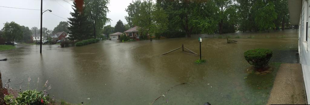
a few more tweets and photos
https://twitter.com/Ryan_Wichman/status/615154816566849537
Oregon, OH flooding this morning.
https://twitter.com/Abby_Batchh/status/615149546704871425
Somewhere in the area.

NWS statements about local rivers.
The flood warning continues for The Maumee River At Waterville.
- At 6:00 AM Sunday the stage was 12.5 feet.
- Flood stage is 11.0 feet.
- Minor Flooding is occurring and Minor flooding is forecast.
- Forecast...the river will rise to near 14.2 feet by this afternoon. Additional rises are possible thereafter.
- At 14.0 feet...Residences along the river may experience basement flooding.
- At 13.0 feet...Floodwaters can back up through storm drains onto Water Street in Waterville making roads inaccessible.
The flood warning continues for The Maumee River Near Grand Rapids.
- Flood stage is 17.5 feet.
- Forecast...the river is forecast to have a maximum value of 19.3 feet this morning.
- At 19.5 feet...Front Street inundated. Numerous farm fields and parking lots flooded. Businesses threatened in Grand Rapids.
- At 18.5 feet...100 year flood level. Mary Jane Thursten State Park Campground inundated. Homes in Wood County cut off from emergency access. Portions of route 24 inundated. The metropark facilities inundated.
A flood warning for urban areas and small streams remains in effect until 3:45 p.m. today for Wood and Lucas counties.
it's a mostly sunny, breezy, and amazingly comfortable morning.
TOL: Jun 28, 2015 9:52 am
Weather : A Few Clouds
Temperature : 65 F
Humidity : 70%
Wind Speed : NW 13 mph
Barometer : 29.87 in
Dewpoint: 55 F
Visibility : 10.00 statute miles
photos along the lakeshore
hazardous weather outlook
national weather service cleveland oh
515 am edt sun jun 28 2015
ohz003-007-009>012-089-paz001-290915-
lucas-ottawa-erie oh-lorain-cuyahoga-lake-ashtabula lakeshore-
northern erie-
515 am edt sun jun 28 2015
...beach hazards statement in effect until 4 pm edt this afternoon...
this hazardous weather outlook is for north central
ohio...northeast ohio...northwest ohio and northwest pennsylvania.
.day one...today and tonight.
please listen to noaa weather radio or go to weather.gov on the
internet for more information about the following hazards.
beach hazards statement.
.days two through seven...monday through saturday.
another round of rain will move through the area monday afternoon
and night. most areas will see between a quarter and three
quarters of an inch of rain but locally higher amounts are
possible. given the saturated soil across the area...water will
run-off and could lead to minor flooding or aggravate existing
flooding. scattered thunderstorms are expected on tuesday.
.spotter information statement...
spotter activation is not expected at this time.
$$
flood warning
flood warning
national weather service cleveland oh
129 pm edt sun jun 28 2015
ohc095-173-291945-
/o.ext.kcle.fa.w.0013.000000t0000z-150629t1945z/
/00000.0.er.000000t0000z.000000t0000z.000000t0000z.oo/
wood oh-lucas oh-
129 pm edt sun jun 28 2015
the national weather service in cleveland has extended the
- flood warning for urban areas and small streams in...
wood county in northwestern ohio...
lucas county in northwestern ohio...
- until 345 pm edt monday
- at 125 pm edt...local law enforcement continues to indicate
numerous road closures across lucas and wood counties. all creeks
and streams are in flood and will likely remain that way into the
overnight. water levels may recede slightly by monday morning but
another round of rain is likely.
precautionary/preparedness actions...
most flood deaths occur in automobiles. never drive your vehicle into
areas where the water covers the roadway. flood waters are usually
deeper than they appear. just one foot of flowing water is powerful
enough to sweep vehicles off the road. when encountering flooded
roads make the smart choice...turn around...dont drown.
&&
lat...lon 4172 8387 4173 8346 4173 8345 4172 8347
4169 8343 4169 8335 4171 8334 4164 8323
4163 8318 4174 8311 4162 8318 4162 8342
4117 8342 4117 8388 4118 8388
$$
mullen
flood warning
flood statement
national weather service cleveland oh
109 pm edt sun jun 28 2015
...the flood warning continues for the following rivers in ohio...
grand river at painesville
blanchard river near findlay
maumee river near grand rapids
scioto river near larue
portage river at woodville
maumee river at waterville
mahoning river at leavittsburg
mahoning river at warren
eagle creek at phalanx station
precautionary/preparedness actions...
never drive your car through flooded roadways. the water may be
deeper than it appears. turn around...don`t drown!
stay tuned to noaa weather radio and other local media for further
details and updates.
&&
ohc095-173-290108-
/o.con.kcle.fl.w.0056.000000t0000z-000000t0000z/
/wtvo1.1.er.000000t0000z.150629t0600z.000000t0000z.no/
109 pm edt sun jun 28 2015
the flood warning continues for
the maumee river at waterville.
* at 1:00 pm sunday the stage was 13.3 feet.
* flood stage is 11.0 feet.
* minor flooding is occurring and minor flooding is forecast.
* forecast...the river will rise to near 13.9 feet by late tonight.
additional rises are possible thereafter.
* at 14.0 feet...residences along the river may experience basement
flooding.
* at 13.0 feet...floodwaters can back up through storm drains onto
water street in waterville making roads inaccessible.
&&
lat...lon 4148 8376 4171 8348 4167 8345 4147 8371
4145 8374
$$
flood warning
flood statement
national weather service cleveland oh
109 pm edt sun jun 28 2015
...the flood warning continues for the following rivers in ohio...
grand river at painesville
blanchard river near findlay
maumee river near grand rapids
scioto river near larue
portage river at woodville
maumee river at waterville
mahoning river at leavittsburg
mahoning river at warren
eagle creek at phalanx station
precautionary/preparedness actions...
never drive your car through flooded roadways. the water may be
deeper than it appears. turn around...don`t drown!
stay tuned to noaa weather radio and other local media for further
details and updates.
&&
ohc095-173-290108-
/o.ext.kcle.fl.w.0058.000000t0000z-150630t1647z/
/grro1.1.er.150628t1553z.150629t0600z.150630t0447z.no/
109 pm edt sun jun 28 2015
the flood warning continues for
the maumee river near grand rapids.
* at 9:41 am sunday the stage was 17.1 feet.
* flood stage is 17.5 feet.
* minor flooding is forecast.
* forecast...the river will rise to around 17.5 feet late this
afternoon and then begin falling.
* at 17.5 feet...flood waters inundate grand rapids road cutting off
access to a few homes. mill street access on the east end of front
street flooded. route 24 threatened by rising flood waters. water
can back up through storm drains causing flooding on the south side
of grand rapids.
* at 16.5 feet...low lying land near grand rapids floods.
&&
lat...lon 4143 8388 4148 8376 4145 8374 4139 8388
$$
beach hazards statement
coastal hazard message
national weather service cleveland oh
943 am edt sun jun 28 2015
ohz003-007-009>012-089-paz001-282000-
/o.con.kcle.bh.s.0004.000000t0000z-150628t2000z/
lucas-ottawa-erie oh-lorain-cuyahoga-lake-ashtabula lakeshore-
northern erie-
943 am edt sun jun 28 2015
...beach hazards statement remains in effect until 4 pm edt this
afternoon...
- hazards...dangerous swimming conditions.
- timing...through sunday afternoon.
- location...all beaches from lucas county ohio to erie county
pennsylvania.
- potential impacts...large waves will cause rip currents to
develop.
precautionary/preparedness actions...
swimming risk exists today. the combination of wind and or waves
will make for potentially dangerous conditions for swimmers
including the risk of rip currents. follow the instruction of
local authorities or stay out of the water.
From JR's : articles
4685 words - 32551 chars
- 26 min read
created on
updated on
- #
source
- versions
Related articles
Severe weather threat for Sun, Nov 17, 2013 - Nov 18, 2013
Nov 17, 2013 Toledo area weather notes - Mar 03, 2014
Posts related to Nov 17, 2013 severe weather - Nov 21, 2013
Toledo area weather for early December 2013 - Dec 05, 2013
Mon, Dec 9, 2013 winter storm forecast for Sat, Dec 14 - Dec 14, 2013
more >>