Toledo weather - sun-mon, aug 2-3, 2015
hazardous weather outlook
national weather service cleveland oh
449 am edt sun aug 2 2015
for lake erie...north central
ohio...northeast ohio...northwest ohio and northwest pennsylvania.
.day one...today and tonight.
severe thunderstorms are expected to develop over the great lakes
today and move southeast tonight ahead of a cold front. if the
storms maintain their intensity...damaging winds are possible
tonight. the best chance would be across northwest ohio and the
counties near lake erie.
.days two through seven...monday through saturday.
the cold front may still be in the area on monday. strong to
severe thunderstorms may develop again along the cold front.
damaging winds would be the threat with the best chance from
around youngstown to canton and mount vernon and points southeast.
.spotter information statement...
spotter activation may be needed tonight.
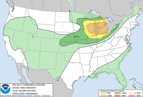
The Toledo area barely resides in the "Enhanced Risk" for severe weather later today/tonight.
This morning's HWO:
severe thunderstorms are expected to develop over the great lakes today and move southeast tonight ahead of a cold front.if the storms maintain their intensity... damaging winds are possible tonight.
the best chance would be across northwest ohio and the counties near lake erie.
Early morning AFD:
there will likely be several waves of thunderstorms across the northern and central lakes and early tonight they will make a push southeast ahead of the cold front.not sure how far south they can get without losing some steam but the thunderstorms could roll into toledo and across lake erie...
the best guess is be 03z- 06z [11pm - 2am].
It looks a little active up north.

md 1592 concerning severe thunderstorm watch 462...463... for sern wi...srn lwr mi
mesoscale discussion 1592
nws storm prediction center norman ok
0802 pm cdt sun aug 02 2015
areas affected...sern wi...srn lwr mi
concerning...severe thunderstorm watch 462...463...
valid 030102z - 030300z
the severe weather threat for severe thunderstorm watch
462...463...continues.
summary...the risk for severe winds and hail continues with ongoing
convection as it gradually develops southward this evening. trends
on the western flank of the convective system will continue to be
monitored for the possibility of a new watch across southern lake
michigan and adjacent northeastern illinois/northern indiana/
southwestern lower michigan.
discussion...convective outflow over central portions of eastern
lower michigan has spread south of stronger lingering convection now
to the northwest through north and east of flint...and the leading
edge appears to be advancing southward at around 20 kt. this
boundary is intersected over western portions of central lower
michigan by another arcing band of convection...curving from north
of grand rapids into the milwaukee vicinity...where inflow of
moderate to large boundary layer based cape is maintaining the most
vigorous storm development in the presence of seasonably strong deep
layer shear.
it still appears possible that the boundary intersection over
interior southern lower michigan could contribute to convective
intensification between now and 01-03z...aided by forcing associated
with an approaching upper impulse which is now pivoting into/through
the upper great lakes region.
otherwise...locally enhanced convergence along the southward
advancing outflow near the lake michigan coast between milwaukee and
chicago may maintain the most prominent convection during the next
few hours. although large hail has been the primary threat with
this activity to this point...in the presence of 40+ kt west
southwesterly mean lower/mid tropospheric flow...cold pool
strengthening accompanied by increasingly strong surface gusts does
not yet appear out of the question.
..kerr.. 08/03/2015
...please see www.spc.noaa.gov for graphic product...
attn...wfo...dtx...apx...iwx...grr...lot...mkx...
lat...lon 42688206 42478243 41818351 41788562 41738640 41418761
42258820 43138847 43538773 43378562 43998424 43338233
42688206
read more
For some reason, data is off by one hour. it should start with 11:45 pm. Same for Central Toledo.
Sylvania
Next Hour: Heavy rain starting in 35 min.
10:45 pm 0 chance of precip
10:46 pm 0 chance of precip
10:47 pm 0 chance of precip
10:48 pm 0 chance of precip
10:49 pm 0 chance of precip
10:50 pm 0 chance of precip
10:51 pm 0 chance of precip
10:52 pm 0 chance of precip
10:53 pm 0 chance of precip
10:54 pm 0 chance of precip
10:55 pm 0 chance of precip
10:56 pm 0 chance of precip
10:57 pm 0 chance of precip
10:58 pm 0 chance of precip
10:59 pm 0 chance of precip
11:00 pm 0 chance of precip
11:01 pm 0 chance of precip
11:02 pm 0 chance of precip
11:03 pm 0 chance of precip
11:04 pm 1 chance of very light rain
11:05 pm 1 chance of very light rain
11:06 pm 1 chance of very light rain
11:07 pm 2 chance of very light rain
11:08 pm 3 chance of very light rain
11:09 pm 4 chance of very light rain
11:10 pm 6 chance of very light rain
11:11 pm 7 chance of very light rain
11:12 pm 7 chance of very light rain
11:13 pm 8 chance of very light rain
11:14 pm 9 chance of very light rain
11:15 pm 10 chance of very light rain
11:16 pm 11 chance of very light rain
11:17 pm 14 chance of very light rain
11:18 pm 17 chance of very light rain
11:19 pm 20 chance of very light rain
11:20 pm 27 chance of very light rain
11:21 pm 32 chance of very light rain
11:22 pm 38 chance of very light rain
11:23 pm 48 chance of very light rain
11:24 pm 51 chance of very light rain
11:25 pm 54 chance of very light rain
11:26 pm 56 chance of very light rain
11:27 pm 59 chance of light rain
11:28 pm 62 chance of light rain
11:29 pm 67 chance of light rain
11:30 pm 72 chance of light to moderate rain
11:31 pm 75 chance of light to moderate rain
11:32 pm 78 chance of moderate rain
11:33 pm 81 chance of moderate rain
11:34 pm 84 chance of moderate rain
11:35 pm 86 chance of moderate to heavy rain
11:36 pm 88 chance of moderate to heavy rain
11:37 pm 90 chance of moderate to heavy rain
11:38 pm 93 chance of heavy rain
11:39 pm 93 chance of heavy rain
11:40 pm 94 chance of heavy rain
11:41 pm 95 chance of heavy to very heavy rain
11:42 pm 96 chance of heavy to very heavy rain
11:43 pm 97 chance of heavy to very heavy rain
11:44 pm 97 chance of very heavy rain
11:45 pm 98 % chance of very heavy rain
Central Toledo
Next Hour: Rain starting in 45 min.
10:45 pm 0 chance of precip
10:46 pm 0 chance of precip
10:47 pm 0 chance of precip
10:48 pm 0 chance of precip
10:49 pm 0 chance of precip
10:50 pm 0 chance of precip
10:51 pm 0 chance of precip
10:52 pm 0 chance of precip
10:53 pm 0 chance of precip
10:54 pm 0 chance of precip
10:55 pm 0 chance of precip
10:56 pm 0 chance of precip
10:57 pm 0 chance of precip
10:58 pm 0 chance of precip
10:59 pm 0 chance of precip
11:00 pm 0 chance of precip
11:01 pm 0 chance of precip
11:02 pm 0 chance of precip
11:03 pm 0 chance of precip
11:04 pm 0 chance of precip
11:05 pm 0 chance of precip
11:06 pm 0 chance of precip
11:07 pm 0 chance of precip
11:08 pm 0 chance of precip
11:09 pm 0 chance of precip
11:10 pm 1 chance of very light rain
11:11 pm 1 chance of very light rain
11:12 pm 1 chance of very light rain
11:13 pm 1 chance of very light rain
11:14 pm 2 chance of very light rain
11:15 pm 2 chance of very light rain
11:16 pm 3 chance of very light rain
11:17 pm 4 chance of very light rain
11:18 pm 5 chance of very light rain
11:19 pm 6 chance of very light rain
11:20 pm 7 chance of very light rain
11:21 pm 8 chance of very light rain
11:22 pm 9 chance of very light rain
11:23 pm 10 chance of very light rain
11:24 pm 12 chance of very light rain
11:25 pm 14 chance of very light rain
11:26 pm 17 chance of very light rain
11:27 pm 21 chance of very light rain
11:28 pm 26 chance of very light rain
11:29 pm 31 chance of very light rain
11:30 pm 42 chance of very light rain
11:31 pm 47 chance of very light rain
11:32 pm 49 chance of very light rain
11:33 pm 50 chance of very light rain
11:34 pm 52 chance of very light rain
11:35 pm 54 chance of light rain
11:36 pm 57 chance of light rain
11:37 pm 58 chance of light rain
11:38 pm 65 chance of light to moderate rain
11:39 pm 66 chance of light to moderate rain
11:40 pm 70 chance of light to moderate rain
11:41 pm 74 chance of moderate rain
11:42 pm 76 chance of moderate rain
11:43 pm 79 chance of moderate rain
11:44 pm 81 chance of moderate rain
11:45 pm 83 % chance of moderate to heavy rain
Severe Thunderstorm Warning
Statement as of 11:42 PM EDT on August 02, 2015
The National Weather Service in northern Indiana has issued a
- Severe Thunderstorm Warning for...
southeastern Branch County in southwestern Michigan...
southern Hillsdale County in southeastern Michigan...
Williams County in northwestern Ohio...
Fulton County in northwestern Ohio...
- until 1230 am EDT
- at 1142 PM EDT... severe thunderstorms were located along a line
extending from near Hillsdale to near reading... moving southeast at
45 mph.
Hazard... 60 mph wind gusts and quarter size hail.
Source... radar indicated.
Impact... hail damage to vehicles is expected. Expect wind damage
to roofs... siding and trees.
- Locations impacted include...
Bryan... Hillsdale... Wauseon... Archbold... Montpelier... Swanton...
Morenci... Delta... Hudson... West Unity... Pioneer... Stryker...
Fayette... reading... Edon... Holiday City... Long Lake... Columbia...
West Jefferson and Cambria.
This includes Interstate 80 in Ohio between mile markers 1 and 48.
Precautionary/preparedness actions...
For your protection move to an interior room on the lowest floor of a
building.
Lat... Lon 4150 8388 4147 8480 4176 8481 4176 8484
4187 8494 4195 8449 4192 8436 4171 8436
4172 8388
time... Mot... loc 0342z 314deg 40kt 4190 8453 4185 8486
Hail... 1.00in
wind... 60mph
Pbm
Forecast.io data
Sylvania
Next Hour: Heavy rain for the hour.
12:40 am 100 chance of very heavy rain
12:41 am 99 chance of very heavy rain
12:42 am 99 chance of very heavy rain
12:43 am 99 chance of very heavy rain
12:44 am 100 chance of very heavy rain
12:45 am 100 chance of very heavy rain
12:46 am 100 chance of very heavy rain
12:47 am 100 chance of very heavy rain
12:48 am 100 chance of very heavy rain
12:49 am 100 chance of very heavy rain
12:50 am 100 chance of very heavy rain
12:51 am 100 chance of very heavy rain
12:52 am 100 chance of heavy to very heavy rain
12:53 am 100 chance of heavy to very heavy rain
12:54 am 100 chance of heavy to very heavy rain
12:55 am 100 chance of heavy to very heavy rain
12:56 am 100 chance of heavy to very heavy rain
12:57 am 100 chance of heavy to very heavy rain
12:58 am 100 chance of heavy to very heavy rain
12:59 am 100 chance of heavy to very heavy rain
1:00 am 100 chance of heavy rain
1:01 am 100 chance of heavy rain
1:02 am 100 chance of heavy rain
1:03 am 100 chance of heavy rain
1:04 am 100 chance of heavy rain
1:05 am 100 chance of heavy rain
1:06 am 100 chance of heavy rain
1:07 am 100 chance of heavy rain
1:08 am 100 chance of heavy rain
1:09 am 100 chance of heavy rain
1:10 am 100 chance of moderate to heavy rain
1:11 am 100 chance of moderate to heavy rain
1:12 am 100 chance of moderate to heavy rain
1:13 am 100 chance of moderate to heavy rain
1:14 am 100 chance of moderate to heavy rain
1:15 am 100 chance of moderate to heavy rain
1:16 am 100 chance of moderate to heavy rain
1:17 am 100 chance of moderate to heavy rain
1:18 am 100 chance of moderate to heavy rain
1:19 am 100 chance of moderate to heavy rain
1:20 am 100 chance of moderate to heavy rain
1:21 am 100 chance of moderate to heavy rain
1:22 am 100 chance of moderate to heavy rain
1:23 am 100 chance of moderate to heavy rain
1:24 am 100 chance of moderate rain
1:25 am 100 chance of moderate rain
1:26 am 100 chance of moderate rain
1:27 am 100 chance of moderate rain
1:28 am 100 chance of moderate rain
1:29 am 100 chance of moderate rain
1:30 am 100 chance of moderate rain
1:31 am 100 chance of moderate rain
1:32 am 100 chance of moderate rain
1:33 am 100 chance of moderate rain
1:34 am 100 chance of moderate rain
1:35 am 100 chance of moderate rain
1:36 am 100 chance of moderate rain
1:37 am 100 chance of moderate rain
1:38 am 100 chance of moderate rain
1:39 am 100 chance of moderate rain
1:40 am 100 % chance of moderate rain
Central Toledo
Next Hour: Heavy rain for the hour.
12:40 am 94 chance of light rain
12:41 am 93 chance of light rain
12:42 am 88 chance of moderate rain
12:43 am 90 chance of moderate rain
12:44 am 92 chance of moderate to heavy rain
12:45 am 92 chance of moderate to heavy rain
12:46 am 93 chance of heavy rain
12:47 am 94 chance of heavy rain
12:48 am 94 chance of heavy rain
12:49 am 95 chance of heavy rain
12:50 am 95 chance of heavy to very heavy rain
12:51 am 96 chance of heavy to very heavy rain
12:52 am 96 chance of heavy to very heavy rain
12:53 am 96 chance of heavy to very heavy rain
12:54 am 96 chance of heavy to very heavy rain
12:55 am 96 chance of heavy to very heavy rain
12:56 am 97 chance of heavy to very heavy rain
12:57 am 97 chance of heavy to very heavy rain
12:58 am 97 chance of heavy to very heavy rain
12:59 am 97 chance of heavy to very heavy rain
1:00 am 97 chance of heavy to very heavy rain
1:01 am 97 chance of heavy to very heavy rain
1:02 am 97 chance of heavy to very heavy rain
1:03 am 98 chance of heavy to very heavy rain
1:04 am 98 chance of heavy rain
1:05 am 98 chance of heavy rain
1:06 am 98 chance of heavy rain
1:07 am 98 chance of heavy rain
1:08 am 98 chance of heavy rain
1:09 am 98 chance of heavy rain
1:10 am 98 chance of heavy rain
1:11 am 98 chance of heavy rain
1:12 am 98 chance of heavy rain
1:13 am 98 chance of heavy rain
1:14 am 98 chance of moderate to heavy rain
1:15 am 98 chance of moderate to heavy rain
1:16 am 98 chance of moderate to heavy rain
1:17 am 98 chance of moderate to heavy rain
1:18 am 98 chance of moderate to heavy rain
1:19 am 98 chance of moderate to heavy rain
1:20 am 98 chance of moderate to heavy rain
1:21 am 98 chance of moderate to heavy rain
1:22 am 98 chance of moderate to heavy rain
1:23 am 98 chance of moderate to heavy rain
1:24 am 98 chance of moderate to heavy rain
1:25 am 98 chance of moderate to heavy rain
1:26 am 98 chance of moderate to heavy rain
1:27 am 98 chance of moderate to heavy rain
1:28 am 98 chance of moderate to heavy rain
1:29 am 98 chance of moderate to heavy rain
1:30 am 100 chance of moderate rain
1:31 am 100 chance of moderate rain
1:32 am 100 chance of moderate rain
1:33 am 100 chance of moderate rain
1:34 am 100 chance of moderate rain
1:35 am 100 chance of moderate rain
1:36 am 100 chance of moderate rain
1:37 am 100 chance of moderate rain
1:38 am 100 chance of moderate rain
1:39 am 100 chance of moderate rain
1:40 am 100 % chance of moderate rain
short term forecast
national weather service cleveland oh
1224 am edt mon aug 3 2015
ohz003-006>008-030515-
lucas-ottawa-wood-sandusky-
1224 am edt mon aug 3 2015
.now...
at 1221 am edt...doppler radar indicated a line of showers and
thunderstorms...along a line extending from near stryker ohio to monroe michigan
moving southeast at 30 mph.
through 130 am locations to be impacted include
toledo...bowling green...perrysburg...oregon...sylvania...
waterville...northwood...genoa...holland...weston...elmore...maumee...
ottawa hills...walbridge...millbury...haskins...luckey and grand rapids.
$$
thompson

md 1593 concerning severe thunderstorm watch 463...465... for parts of nrn il...nrn ind...nrn oh and srn lwr mi
mesoscale discussion 1593
nws storm prediction center norman ok
1119 pm cdt sun aug 02 2015
areas affected...parts of nrn il...nrn ind...nrn oh and srn lwr mi
concerning...severe thunderstorm watch 463...465...
valid 030419z - 030545z
the severe weather threat for severe thunderstorm watch
463...465...continues.
summary...the severe wind/hail threat is expected to gradually
diminish with a lingering line of storms overspreading the region
through 05-07z. a new watch is not currently anticipated for
northern ohio...but trends will continue to be monitored for this
possibility.
discussion...the leading edge of conglomerate convective outflow
continues to advance southward through southern portions of the
great lakes region at up to 30 kt. lift along this feature has
remained sufficient to support renewed vigorous thunderstorm
development... but lightning and radar data suggest general
intensity trends are on the downward swing. stronger mid/upper
forcing for ascent associated with the vigorous short wave impulse
pivoting through the upper great lakes region appears likely to
begin turning eastward toward southern ontario/quebec shortly. as
this occurs...40-50 kt westerly lower/mid tropospheric wind fields
currently present across the southern great lakes region should
begin to weaken. coupled with continued boundary layer cooling
within a narrowing pre-convective line instability axis...severe
weather potential with lingering convection is expected to diminish
through the 05-07z time.
..kerr.. 08/03/2015
...please see www.spc.noaa.gov for graphic product...
attn...wfo...cle...iln...iwx...ind...lot...
lat...lon 41388692 41298457 41558375 41778168 42158083 42078037
41338090 40888276 40398594 40598822 41548904 41388692
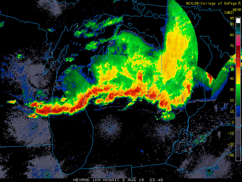
At 12:45 a.m., thundershower with moderate to heavy rainfall over West Toledo.
12:40 a.m. snapshot.

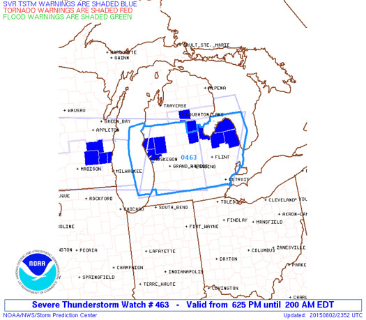
Mesoscale discussion issued at 12:19 a.m.
Warned areas as of 12:46 a.m.

special weather statement
special weather statement
national weather service cleveland oh
101 am edt mon aug 3 2015
ohz003-006>009-017-018-030600-
lucas-hancock-erie-ottawa-wood-seneca-sandusky-
101 am edt mon aug 3 2015
...a line of strong thunderstorms will affect wood...sandusky...
northwestern seneca...erie...southwestern lucas...ottawa and northern
hancock counties...
at 1259 am edt...a line of strong thunderstorms was along a line
extending from 11 miles northeast of kelleys island to 6 miles
northwest of oak harbor to 7 miles northeast of defiance...and
moving east at 15 mph.
winds in excess of 40 mph are possible with these storms.
torrential rainfall is also occurring with these storms...and may
cause localized flooding. do not drive your vehicle through flooded
roadways.
these storms may intensify...so be certain to monitor local radio and
tv stations...as well as local cable tv outlets...for additional
information and possible warnings from the national weather service.
From JR's : articles
3216 words - 19008 chars
- 17 min read
created on
updated on
- #
source
- versions
Related articles
Severe weather threat for Sun, Nov 17, 2013 - Nov 18, 2013
Nov 17, 2013 Toledo area weather notes - Mar 03, 2014
Posts related to Nov 17, 2013 severe weather - Nov 21, 2013
Toledo area weather for early December 2013 - Dec 05, 2013
Mon, Dec 9, 2013 winter storm forecast for Sat, Dec 14 - Dec 14, 2013
more >>