You're viewing old version number 4. - Current version
Toledo weather - sun, aug 2, 2015
hazardous weather outlook
national weather service cleveland oh
449 am edt sun aug 2 2015
for lake erie...north central
ohio...northeast ohio...northwest ohio and northwest pennsylvania.
.day one...today and tonight.
severe thunderstorms are expected to develop over the great lakes
today and move southeast tonight ahead of a cold front. if the
storms maintain their intensity...damaging winds are possible
tonight. the best chance would be across northwest ohio and the
counties near lake erie.
.days two through seven...monday through saturday.
the cold front may still be in the area on monday. strong to
severe thunderstorms may develop again along the cold front.
damaging winds would be the threat with the best chance from
around youngstown to canton and mount vernon and points southeast.
.spotter information statement...
spotter activation may be needed tonight.
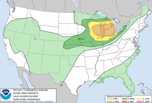
The Toledo area barely resides in the "Enhanced Risk" for severe weather later today/tonight.
This morning's HWO:
severe thunderstorms are expected to develop over the great lakes today and move southeast tonight ahead of a cold front.if the storms maintain their intensity... damaging winds are possible tonight.
the best chance would be across northwest ohio and the counties near lake erie.
Early morning AFD:
there will likely be several waves of thunderstorms across the northern and central lakes and early tonight they will make a push southeast ahead of the cold front.not sure how far south they can get without losing some steam but the thunderstorms could roll into toledo and across lake erie...
the best guess is be 03z- 06z [11pm - 2am].
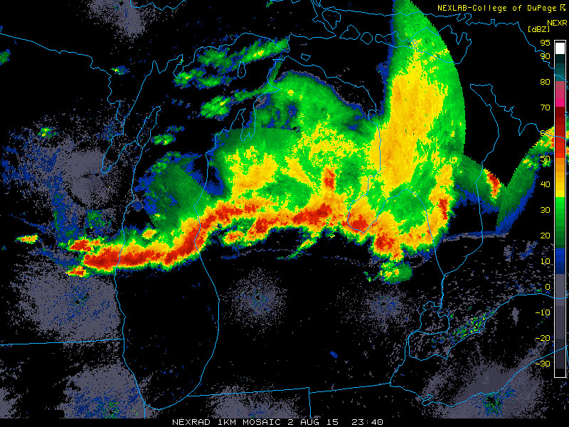
It looks a little active up north.

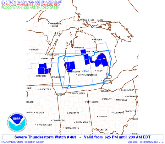
md 1592 concerning severe thunderstorm watch 462...463... for sern wi...srn lwr mi
mesoscale discussion 1592
nws storm prediction center norman ok
0802 pm cdt sun aug 02 2015
areas affected...sern wi...srn lwr mi
concerning...severe thunderstorm watch 462...463...
valid 030102z - 030300z
the severe weather threat for severe thunderstorm watch
462...463...continues.
summary...the risk for severe winds and hail continues with ongoing
convection as it gradually develops southward this evening. trends
on the western flank of the convective system will continue to be
monitored for the possibility of a new watch across southern lake
michigan and adjacent northeastern illinois/northern indiana/
southwestern lower michigan.
discussion...convective outflow over central portions of eastern
lower michigan has spread south of stronger lingering convection now
to the northwest through north and east of flint...and the leading
edge appears to be advancing southward at around 20 kt. this
boundary is intersected over western portions of central lower
michigan by another arcing band of convection...curving from north
of grand rapids into the milwaukee vicinity...where inflow of
moderate to large boundary layer based cape is maintaining the most
vigorous storm development in the presence of seasonably strong deep
layer shear.
it still appears possible that the boundary intersection over
interior southern lower michigan could contribute to convective
intensification between now and 01-03z...aided by forcing associated
with an approaching upper impulse which is now pivoting into/through
the upper great lakes region.
otherwise...locally enhanced convergence along the southward
advancing outflow near the lake michigan coast between milwaukee and
chicago may maintain the most prominent convection during the next
few hours. although large hail has been the primary threat with
this activity to this point...in the presence of 40+ kt west
southwesterly mean lower/mid tropospheric flow...cold pool
strengthening accompanied by increasingly strong surface gusts does
not yet appear out of the question.
..kerr.. 08/03/2015
...please see www.spc.noaa.gov for graphic product...
attn...wfo...dtx...apx...iwx...grr...lot...mkx...
lat...lon 42688206 42478243 41818351 41788562 41738640 41418761
42258820 43138847 43538773 43378562 43998424 43338233
42688206
read more
From JR's : articles
591 words - 4124 chars
- 3 min read
created on
updated on
- #
source
- versions
Related articles
Severe weather threat for Sun, Nov 17, 2013 - Nov 18, 2013
Nov 17, 2013 Toledo area weather notes - Mar 03, 2014
Posts related to Nov 17, 2013 severe weather - Nov 21, 2013
Toledo area weather for early December 2013 - Dec 05, 2013
Mon, Dec 9, 2013 winter storm forecast for Sat, Dec 14 - Dec 14, 2013
more >>