Toledo Weather - Mon, Sep 8, 2015
This weekend, Sat-Sun, Sep 12-13, will probably be dry with pleasant temps about 20 degrees cooler than this past weekend. That's according to the info below.
From this morning's Toledo forecast issued by the Cleveland National Weather Service :
Saturday : Mostly sunny, with a high near 68.
Saturday Night (sunrise Sunday) : Partly cloudy, with a low around 51.
Here are the forecast temps, based upon Forecast.io data, which averages info from various computer models. Today is the last hot day for a while.
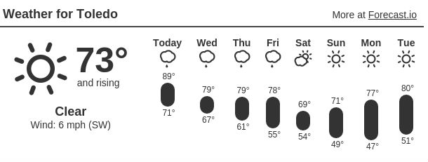
Toledo 7-day forecast
Last Update: Sep 8, 2015 6:31 am
Today: Mostly cloudy, with a high near 89. West wind 5 to 13 mph.
Tonight: Showers and thunderstorms likely, mainly after 3am. Cloudy, with a low around 69. Northwest wind 5 to 9 mph becoming calm after midnight. Chance of precipitation is 60%. New rainfall amounts between a tenth and quarter of an inch, except higher amounts possible in thunderstorms.
Wednesday: Showers and thunderstorms. High near 78. Light and variable wind becoming southeast 6 to 11 mph. Chance of precipitation is 80%. New rainfall amounts between a tenth and quarter of an inch, except higher amounts possible in thunderstorms.
Wednesday Night: Showers and thunderstorms likely, mainly before 9pm. Mostly cloudy, with a low around 60. Light north wind increasing to 5 to 10 mph after midnight. Chance of precipitation is 60%. New rainfall amounts of less than a tenth of an inch, except higher amounts possible in thunderstorms.
Thursday: Mostly sunny, with a high near 76. North wind 6 to 8 mph.
Thursday Night: Mostly clear, with a low around 55.
Friday: Mostly sunny, with a high near 73.
Friday Night: A chance of showers after 1am. Mostly cloudy, with a low around 52. Chance of precipitation is 30%.
Saturday: A chance of showers before 7am. Partly sunny, with a high near 68. Chance of precipitation is 30%.
Saturday Night: Partly cloudy, with a low around 51.
Sunday: Mostly sunny, with a high near 69.
Sunday Night: Partly cloudy, with a low around 54.
Monday: Mostly sunny, with a high near 76.
page created: Sep 08, 2015 - 9:00 a.m. EDT
fxus61 kcle 081115
afdcle
area forecast discussion
national weather service cleveland oh
715 am edt tue sep 8 2015
synopsis...
a slow moving cold front across the central great lakes will stall
north of lake erie today. low pressure will move northeast along
the boundary wednesday and pull the front south across the area.
this will be followed by a second stronger front late friday.
&&
near term /until 6 pm this evening/...
no changes to forecast for 630 update.
original discussion...
slow moving cold front now into central michigan. temps should
be a degree or two cooler than yesterday as should see some
increasing cloud cover as the front slowly sags south. expect weak
lake breeze to develop this afternoon so will leave low pops for
convection across the eastern lakeshore counties. judging from the
6z synoptic obs gfs way too aggressive with the convection and
appears to be suffering from convective feedback. therefore will
lean toward the slower nam and ecmwf timing of convection. that
said do expect more widespread convection across se lower michigan
so will leave chance pops across nw ohio for late this afternoon.
&&
short term /6 pm this evening through friday night/...
little change in the short term forecast. slight timing
differences with the models but trends still the same. expect that
the front will be just nw of the forecast area by daybreak
wednesday with the convection shield into extreme nw ohio. front
and the associated upper level short wave will move across the
forecast area during the day wednesday. front will not exit area
until thursday night. could see some lingering showers in the east
thursday morning but high pressure builds in quickly
thursday....ushering in cooler and drier conditions. this will be
followed late friday with a second reinforcing shot of cold air
with another cold front. for now will just go with a chance of
showers.
&&
long term /saturday through monday/...
upper level trough will move into the forecast area saturday and
begin its transition from a trough to a deepening upper level low
by sunday morning. the upper level feature will then begin to lift
northeast out of the area sunday night into monday as a weak upper
level ridge builds into the forecast area for early next week.
as the upper level low develops...a resultant surface low pressure
will develop over eastern ohio and western pennsylvania saturday
into saturday night. the surface low pressure system will move
north and then retrograde back northwest by sunday night and then
east on monday. surface high pressure will build east under the
upper level ridge monday afternoon.
due to the upper level low and surface low being present over the
local area...the cyclonic flow across the great lakes will likely
cause a lot of clouds to remain persistent across the area. for
now...will continue with the partly cloudy/sunny forecast going
over the weekend and then gradually improve conditions as
subsidence develops under the surface high pressure monday.
the other issue to deal with is the cold air advection expected to
take place under the upper level low. a cold front is progged to
move through the area saturday morning ushering in the cooler air
mass. this air mass will hang around for the rest of the weekend
and begin to retreat monday as high pressure builds east.
&&
aviation /12z tuesday through saturday/...
mainly high clouds will spread east into the forecast area as the
day progresses. then...threat for showers and thunderstorms with
mvfr visibilities possible after 00z this evening in the west and
at erie. otherwise...rest of the taf sites should remain dry
through the forecast period. exception is cleveland should see
thunderstorm activity after 08z but will keep it as vcts.
ceilings should remain predominantly vfr during the thunderstorms.
winds should be 10 knots or less from the south southwest.
outlook...non vfr likely in shra/tsra with a cold front wednesday.
non vfr may linger into thursday morning. non-vfr possible on
saturday with the next cold front.
&&
marine...
winds will remain light south to southwest through much of
wednesday and then become variable in direction as wave of low
pressure moves east over the lake wednesday afternoon.
expecting winds to increase from the north to northwest for a
period wednesday night after the cold front passes south of the
area. but winds will diminish on thursday. may need a small craft
advisory wednesday night for a brief period. otherwise...rest of
the week into the weekend is looking like winds will remain fairly
light from the north to northwest. not expecting any small craft
advisories to be in effect from thursday on.
&&
cle watches/warnings/advisories...
oh...none.
pa...none.
marine...none.
&&
$$
synopsis...djb
near term...djb
short term...djb
long term...lombardy
aviation...lombardy
marine...lombardy
fzus51 kcle 080757
nshcle
nearshore marine forecast
national weather service cleveland oh
357 am edt tue sep 8 2015
for waters within five nautical miles of shore on lake erie
lez142>146-081415-
maumee bay to reno beach oh-reno beach to the islands oh-
the islands to vermilion oh-vermilion to avon point oh-
avon point to willowick oh-
357 am edt tue sep 8 2015
today...southwest winds 10 knots or less. partly sunny. a chance
of showers and thunderstorms this afternoon. waves 2 feet or
less.
tonight...southwest winds 10 knots or less becoming west. mostly
cloudy with a chance of showers and thunderstorms. waves 2 feet
or less.
wednesday...southeast winds 10 knots or less increasing to 5 to
15 knots. showers and thunderstorms likely. waves 2 feet or less.
wednesday night...north winds 5 to 15 knots increasing to 10 to
20 knots. showers and thunderstorms likely in the evening...then
a chance of showers and thunderstorms overnight. waves 1 to
3 feet building to 2 to 4 feet.
winds and waves higher in and near thunderstorms.
see lake erie open lakes forecast for thursday through saturday.
the water temperature off toledo is 71 degrees...off cleveland
73 degrees and off erie 73 degrees.
$$
lez147>149-081415-
willowick to geneva-on-the lake oh-geneva-on-the-
lake to conneaut oh-conneaut oh to ripley ny-
357 am edt tue sep 8 2015
today...south winds 10 knots or less becoming west. mostly
sunny. a chance of showers and thunderstorms this afternoon.
waves 2 feet or less.
tonight...south winds 10 knots or less. partly cloudy in the
evening...then becoming mostly cloudy. a chance of showers and
thunderstorms. waves 2 feet or less.
wednesday...southwest winds 10 knots or less becoming northeast
5 to 15 knots. a chance of showers and thunderstorms in the
morning...then showers and thunderstorms likely in the afternoon.
waves 2 feet or less.
wednesday night...northeast winds 5 to 15 knots becoming north
10 to 20 knots. showers and thunderstorms likely in the evening...
then a chance of showers and thunderstorms overnight. waves
2 feet or less building to 3 to 5 feet. a small craft advisory
will likely be needed.
winds and waves higher in and near thunderstorms.
see lake erie open lakes forecast for thursday through saturday.
the water temperature off toledo is 71 degrees...off cleveland
73 degrees and off erie 73 degrees.
$$
lombardy
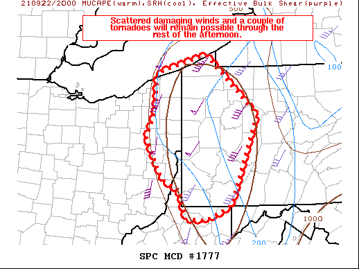
md 1777 concerning severe potential...watch unlikely for portions of lower michigan
mesoscale discussion 1777
nws storm prediction center norman ok
1207 pm cdt tue sep 08 2015
areas affected...portions of lower michigan
concerning...severe potential...watch unlikely
valid 081707z - 081930z
probability of watch issuance...20 percent
summary...tstms will cross portions of lower mi through the
afternoon...offering the potential for a few locally svr wind gusts.
while convective trends will continue to be monitored...ww issuance
is presently unlikely.
discussion...the air mass ahead of a line of tstms presently
crossing lake mi continues to destabilize over lower mi -- s of
widespread clouds and showers/elevated tstms over nrn parts of the
state. with temperatures reaching the upper 70s to around 80f owing
to insolation amidst dewpoints in the lower 70s...mlcape around
1000-2000 j/kg will contribute to maintenance and perhaps
intensification of the aforementioned line of tstms. given nwd
advance of the srn edge of denser cloud coverage ahead of the line
of tstms -- per visible satellite trends -- buoyancy will likely
build nwd across parts of cntrl lower mi -- associated with
potential nwd development of the line of tstms. the grr vwp samples
40-50-kt mid-level wswly flow offering sufficient deep shear for
maintained convective organization and perhaps line-embedded bowing
segments. isolated svr wind gusts will be possible with this
activity...particularly in areas where low-level lapse rates become
relatively steeper owing to stronger insolation. however...with poor
mid-level lapse rates in place...and stronger deep ascent removed
well to the w/nw of the region...confidence in more than an isolated
svr risk is limited -- though convective trends will continue to be
monitored.
..cohen/hart.. 09/08/2015
...please see www.spc.noaa.gov for graphic product...
attn...wfo...dtx...apx...iwx...grr...
lat...lon 43338611 43958555 44018436 43598358 43078338 42428394
42148524 42258639 43338611
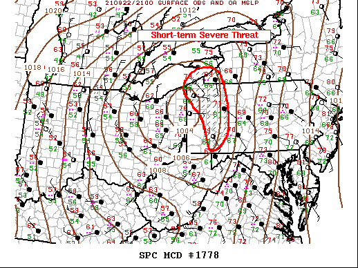
md 1778 concerning severe potential...watch unlikely for east-central il into northwest ind and extreme southwest mi
mesoscale discussion 1778
nws storm prediction center norman ok
0129 pm cdt tue sep 08 2015
areas affected...east-central il into northwest ind and extreme
southwest mi
concerning...severe potential...watch unlikely
valid 081829z - 082000z
probability of watch issuance...20 percent
summary...a few stronger thunderstorms will be possible this
afternoon across east-central il into northwest ind and extreme
southwest mi. overall intensity of storms is expected to remain
below severe limits and a watch is not expected.
discussion...a few stronger storms may produce gusty winds this
afternoon. a line of storms from near ord south/southwest into
central il has shown signs of strengthening and becoming somewhat
organized. while dewpoints in the mid/upper 60s exist downstream
/resulting in weak to moderate instability/...a lack of stronger
midlevel lapse rates and decreasing effective shear and forcing for
ascent with southward extent will limit overall
intensity/organization. that being said...steep low level lapse
rates combined with around 20-30 kt flow at 850 mb could result in a
few stronger wind gusts. in addition to sporadic strong wind
gusts...some small hail also will be possible with stronger cells.
however...a watch is not expected at this time given aforementioned
limiting factors and the expectations any severe activity will be
limited in both time and space.
..leitman/hart.. 09/08/2015
...please see www.spc.noaa.gov for graphic product...
attn...wfo...iwx...grr...ind...lot...ilx...
lat...lon 39378812 39408880 39568924 39768929 40378889 41858767
42138698 42128631 41988600 41728598 41118607 40138692
39598755 39378812
TOL:
Sep 8, 2015 2:52 pm
Weather : A Few Clouds
Temperature : 89 F
Humidity : 50%
Wind Speed : SW 14 mph - Gust 18 mph
Barometer : 29.88 in
Dewpoint: 68 F
Visibility : 10.00 statute miles
Heat Index : 93 F
(formerly Metcalf Airport)
Sep 8, 2015 2:53 pm
Weather : Fair
Temperature : 89 F
Humidity : 47%
Wind Speed : SSW 12 mph - Gust 22 mph
Barometer : 29.89 in
Dewpoint: 66 F
Visibility : 10.00 statute miles
Heat Index : 92 F
(near Lambertville)
Sep 8, 2015 3:34 pm
Weather : Fair
Temperature : 89 F
Humidity : 48%
Wind Speed : SW 9 mph - Gust 18 mph
Barometer : 29.87 in
Dewpoint: 67 F
Visibility : 10.00 statute miles
Heat Index : 92 F

md 1780 concerning severe potential...watch unlikely for eastern lower mi
mesoscale discussion 1780
nws storm prediction center norman ok
0259 pm cdt tue sep 08 2015
areas affected...eastern lower mi
concerning...severe potential...watch unlikely
valid 081959z - 082130z
probability of watch issuance...20 percent
summary...sporadic strong wind gusts will be possible across eastern
lower mi into this evening. the threat is expected to remain
isolated and generally below severe limits and a watch is not
expected at this time.
discussion...a band of strong storms across central mi will continue
to track eastward into a slightly more favorable environment cross
eastern lower mi. here...greater heating has resulting in mucape
values near 2000 j/kg. additionally...effective shear approaching
40-50 kt will aid in maintaining stronger bowing segments. despite
this...midlevel lapse rates continue to be poor so any stronger
updrafts will likely be intermittent and short-lived. this will
limit hail potential...but steep low level lapse rates will further
support sporadic strong wind gusts.
while the severe threat is expected to remain limited...a narrow
corridor may exist where some low level rotation/non-zer0 brief
spin-up may occur near the eastward surging convection and an
effective warm frontal zone near/north of the thumb of mi.
however...confidence is low in this scenario. a watch is not
expected at this time...but trends will continue to be monitored.
..leitman/hart.. 09/08/2015
...please see www.spc.noaa.gov for graphic product...
attn...wfo...cle...dtx...apx...iwx...grr...
lat...lon 42168294 41718354 41878473 43208471 44678410 44748347
44638287 44108239 43668230 43148237 42538258 42168294
TOL:
Sep 8, 2015 3:52 pm
Weather : Fair
Temperature : 90 F
Humidity : 47%
Wind Speed : SW 13 mph - Gust 35 mph
Barometer : 29.86 in
Dewpoint: 67 F
Visibility : 10.00 statute miles
Heat Index : 93 F
(near Lambertville)
Sep 8, 2015 3:55 pm
Weather : Fair
Temperature : 90 F
Humidity : 49%
Wind Speed : SW 8 mph
Barometer : 29.87 in
Dewpoint: 68 F
Visibility : 10.00 statute miles
Heat Index : 94 F
From JR's : articles
2512 words - 16046 chars
- 13 min read
created on
updated on
- #
source
- versions
Related articles
Severe weather threat for Sun, Nov 17, 2013 - Nov 18, 2013
Nov 17, 2013 Toledo area weather notes - Mar 03, 2014
Posts related to Nov 17, 2013 severe weather - Nov 21, 2013
Toledo area weather for early December 2013 - Dec 05, 2013
Mon, Dec 9, 2013 winter storm forecast for Sat, Dec 14 - Dec 14, 2013
more >>