Toledo Weather - Mon, Oct 12, 2015
TOL:
Oct 12, 2015 6:52 am
Weather : Fair
Temperature : 51 F
Humidity : 80%
Wind Speed : S 8 mph
Barometer : 29.69 in
Dewpoint: 45 F
Visibility : 10.00 statute miles
(formerly Metcalf Airport)
Oct 12, 2015 6:53 am
Weather : Fair
Temperature : 53 F
Humidity : 74%
Wind Speed : S 8 mph
Barometer : 29.71 in
Dewpoint: 45 F
Visibility : 10.00 statute miles
(near Lambertville)
Oct 12, 2015 6:55 am
Weather : Fair
Temperature : 56 F
Humidity : 70%
Wind Speed : S 8 mph
Barometer : 29.69 in
Dewpoint: 46 F
Visibility : 10.00 statute miles
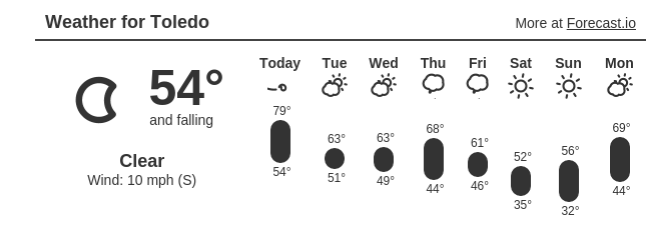
Toledo 7-day forecast
Last Update: Oct 12, 2015 6:23 am
Columbus Day: Mostly sunny, with a high near 76. Southwest wind 10 to 18 mph, with gusts as high as 28 mph.
Tonight: Mostly cloudy, with a low around 51. Southwest wind 8 to 11 mph.
Tuesday: Partly sunny, with a high near 59. West wind 11 to 17 mph.
Tuesday Night: Mostly cloudy, with a low around 42. West wind 8 to 13 mph becoming light after midnight.
Wednesday: Mostly sunny, with a high near 61. Light west wind increasing to 8 to 13 mph in the morning.
Wednesday Night: Mostly clear, with a low around 42.
Thursday: Mostly sunny, with a high near 63.
Thursday Night: A chance of showers. Mostly cloudy, with a low around 44. Chance of precipitation is 30%.
Friday: Mostly sunny, with a high near 57.
Friday Night: Partly cloudy, with a low around 37.
Saturday: Mostly sunny, with a high near 53.
Saturday Night: Partly cloudy, with a low around 35.
Sunday: Mostly sunny, with a high near 54.
fxus61 kcle 121022
afdcle
area forecast discussion
national weather service cleveland oh
622 am edt mon oct 12 2015
synopsis...
a cold front across the mid mississippi valley will move across
the forecast area tonight. a secondary cold front will move across
the area tuesday...ushering in much cooler conditions and some
lake effect showers in the east.
&&
near term /until 6 pm this evening/...
no significant changes to forecast...just tweaked cloud cover for
630 update.
original discussion...
today will be the last of the 70 degree weather in the nearterm.
southerly flow will increase during the day ahead of approaching
cold front. clear skies this morning will give way to thickening
clouds this afternoon. with dew points in the 40s and limited
moisture source think showers will have a difficult time this
afternoon.
&&
short term /6 pm this evening through thursday night/...
think there is a better chance of showers tonight with the cold
front itself...but models still not in good agreement. nam is
basically a dry forecast while the gfs and the ecmwf produce roughly
a tenth of an inch overnight in the east. that seems more
reasonable with the lift from the front and the orographic lift. so
for now will just go with chance pops in the east tonight.
think there will be a break tuesday morning...then a secondary cold
front will blast the area tuesday. the 850 mb temps plunge to
around zero c wednesday...setting up potential for lake effect
showers...with lake to 850mb differential around 16c. with a nw to
w flow showers should be confined to snowbelt area east of cle.
for now will just continue with chance pops tuesday night into
thursday. ridge of high pressure moves across upper ohio valley
thursday choking off lake effect. but dry conditions will be short
lived as both the gfs and ecmwf in good agreement moving next cold
front across the area thursday night.
&&
long term /friday through sunday/...
long wave trough will remain over the region through the long term
which generally produces cooler conditions. models are actually in
decent agreement on the timing of storm systems moving through this
flow. another cold front will move across the region on friday with
a few showers near and ahead of it. colder air will then spill
across the relatively warmer waters of lake erie saturday into
sunday. this will likely cause some showers downwind of lake erie.
these will be focused across ne ohio and nw pa. the showers will
generally be north of a line from lorain to warren friday night then
gradually shift eastward saturday into sunday. a few showers may
linger into sunday afternoon across inland nw pa.
it will be colder through the long term. locations that are able to
clear friday night and saturday night will have a chance of frost.
the best chances of frost currently look to be saturday night as
winds decrease. more details on this will come through the week. so
if you still have any tender vegetation you want to protect you may
want to start planning now. highs through the long term are expected
to be in the 50s. however we would not be surprised to see a few
highs in the middle to upper 40s across extreme ne ohio into nw pa
over the weekend.
&&
aviation /06z monday through friday/...
low level jet will move over the region today as a cold front
moves into the central great lakes by early afternoon. winds will
increase quickly after sunrise with fairly deep mixing
anticipated under clear skies. this will allow south to southwest
winds to increase to the 12 to 16 knot range. gusts will likely
top out between 22 and 30 knots.
not all that much moisture ahead of the front so any cloud cover
will be minimal until mid to late afternoon. as the clouds
increase winds should decrease slightly as it cuts off the deep
mixing. however winds will remain elevated into the evening. the
coverage of showers is uncertain but the best chances will be east
of a line from mansfield to cleveland and may actually end up
being closer to the oh/pa border. have only placed vicinity
showers in the tafs at this point.
outlook...non-vfr possible mainly ne oh and nw pa wed thru fri.
&&
marine...
low level jet moving over the region today will cause an increase in
wind speeds. since we are in a warm advection pattern and winds will
be blowing offshore it looks like it will be difficult to reach
small craft advisory levels. it may be close to these levels by late
afternoon but will hold off for now. as winds shift to a westerly
direction in the wake of the front tonight waves will build east of
the islands to ripley. a small craft advisory will be needed at this
point then continue into at least wednesday morning. winds will
shift back to the southwest on thursday with waves relaxing. however
locations east of geneva-on-the-lake may continue to see 3 to 5 foot
waves.
&&
cle watches/warnings/advisories...
oh...none.
pa...none.
marine...none.
&&
$$
synopsis...djb
near term...djb
short term...djb
long term...mullen
aviation...mullen
marine...mullen
tt comment
quote=195714
That long range forecast back on Oct 4 will be close.
Today will be the last relatively warm day for a while with high temps forecast to range from 75 to 80 degrees.
Last Thu, Oct 8, our temps reached the upper 70s, and that evening, I heard a Scissor-grinder Cicada sing around our home. They start singing each summer in late June or early July. A few sing in October on warm days. I did not hear one yesterday evening. Today will probably be the final chance to hear a cicada sing for this year.
High temps fall back to the 50s and 60s for the rest of the week. Some areas may have a chance for frost on Sat-Sun, Oct 17-18.
area forecast discussion - national weather service cleveland oh
723 am edt mon oct 12 2015
locations that are able to clear friday night and saturday night will have a chance of frost. the best chances of frost currently look to be saturday night as winds decrease. more details on this will come through the week. so if you still have any tender vegetation you want to protect you may want to start planning now.
This forecast predicts warmer daytime temps than the NWS forecast.
7:30 a.m., Mon, Oct 12, 2015
Toledo 7-day forecast issued by the Cleveland National Weather Service
Last Update: Oct 12, 2015 6:23 am
Today: Mostly sunny, with a high near 76. Southwest wind 10 to 18 mph, with gusts as high as 28 mph.
Tonight: Mostly cloudy, with a low around 51. Southwest wind 8 to 11 mph.
Tuesday: Partly sunny, with a high near 59. West wind 11 to 17 mph.
Tuesday Night: Mostly cloudy, with a low around 42. West wind 8 to 13 mph becoming light after midnight.
Wednesday: Mostly sunny, with a high near 61. Light west wind increasing to 8 to 13 mph in the morning.
Wednesday Night: Mostly clear, with a low around 42.
Thursday: Mostly sunny, with a high near 63.
Thursday Night: A chance of showers. Mostly cloudy, with a low around 44. Chance of precipitation is 30%.
Friday: Mostly sunny, with a high near 57.
Friday Night: Partly cloudy, with a low around 37.
Saturday: Mostly sunny, with a high near 53.
Saturday Night: Partly cloudy, with a low around 35.
Sunday: Mostly sunny, with a high near 54.
TOL:
Oct 12, 2015 11:52 am
Weather : Fair
Temperature : 70 F
Humidity : 49%
Wind Speed : SSW 10 mph - Gust 22 mph
Barometer : 29.59 in
Dewpoint: 50 F
Visibility : 10.00 statute miles
TOL:
Oct 12, 2015 2:52 pm
Weather : A Few Clouds
Temperature : 79 F
Humidity : 42%
Wind Speed : SSW 16 mph - Gust 23 mph
Barometer : 29.50 in
Dewpoint: 54 F
Visibility : 7.00 statute miles
(formerly Metcalf Airport)
Oct 12, 2015 2:53 pm
Weather : Fair
Temperature : 79 F
Humidity : 41%
Wind Speed : SSW 20 mph - Gust 28 mph
Barometer : 29.52 in
Dewpoint: 53 F
Visibility : 10.00 statute miles
(near Lambertville)
Oct 12, 2015 2:55 pm
Weather : Partly Cloudy
Temperature : 80 F
Humidity : 42%
Wind Speed : SW 13 mph - Gust 17 mph
Barometer : 29.50 in
Dewpoint: 54 F
Visibility : 10.00 statute miles
Heat Index : 80 F
a cloudy afternoon. breezy. mild.
Oct 12, 2015 5:52 pm
Weather : Partly Cloudy
Temperature : 74 F
Humidity : 54%
Wind Speed : SW 13 mph
Barometer : 29.48 in
Dewpoint: 56 F
Visibility : 10.00 statute miles
TOL:
Oct 12, 2015 8:52 pm
Weather : Fair
Temperature : 71 F
Humidity : 59%
Wind Speed : SW 10 mph
Barometer : 29.49 in
Dewpoint: 56 F
Visibility : 10.00 statute miles
(near Lambertville)
Oct 12, 2015 9:15 pm
Weather : Fair
Temperature : 72 F
Humidity : 59%
Wind Speed : WSW 9 mph - Gust 16 mph
Barometer : 29.49 in
Dewpoint: 56 F
Visibility : 10.00 statute miles
From JR's : articles
1812 words - 10248 chars
- 10 min read
created on
updated on
- #
source
- versions
Related articles
Severe weather threat for Sun, Nov 17, 2013 - Nov 18, 2013
Nov 17, 2013 Toledo area weather notes - Mar 03, 2014
Posts related to Nov 17, 2013 severe weather - Nov 21, 2013
Toledo area weather for early December 2013 - Dec 05, 2013
Mon, Dec 9, 2013 winter storm forecast for Sat, Dec 14 - Dec 14, 2013
more >>