Tt proposed post oct 27 2015 - b
On Tuesday afternoon, the Lucas County Emergency Management Agency posted the following tweet.
Screenshot (timestamp is Pacific time)
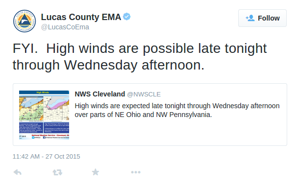
The LCEMA post included a tweet by the Cleveland National Weather Service.
Here's the Cle NWS graphic. Between Tuesday and Thursday night, the expected maximum wind gust for Toledo is 40 mph.

As of 6:15 p.m., no watches, warnings, nor advisories exist for the land portion of Lucas County.
Out on Maumee Bay and near shore of Lake Erie, a small craft advisory exists from 10:00 p.m. tonight (Tuesday) until 6:00 a.m. Thursday. And then a gale watch exists from 6:00 a.m. Thursday until 4:00 p.m. Thursday.
Those are the only alerts for the Toledo area. Right now.
The counties at the eastern end of Lake Erie in northeast Ohio, northwest Pennsylvania, and southwest New York could see wind gusts from 50 to 70 mph.
A High Wind Warning exists along the shoreline area of Erie County, PA and for Chautauqua County in New York. Here's the statement for Chautauqua County.
High Wind Warning remains in effect from 4 am to 4 PM EDT
Wednesday...
- locations... along the Chautauqua ridge and Lake Erie shore
line in western Chautauqua County and southwestern Erie County [NY].
- Timing... early Wednesday morning through late Wednesday
afternoon.
- Winds... [sustained] southeast 30 to 40 mph with gusts up to 70 mph.
For the shoreline area of Erie County, PA:
Winds... sustained south to southeast winds of 25 to 40 mph with occasional gusts in excess of 60 mph possible.
Definition of a High Wind Warning:
High Wind Warning: Issued for when sustained winds will be 40 mph or greater for at least one hour, or any gust of wind expected to be 58 mph or greater.
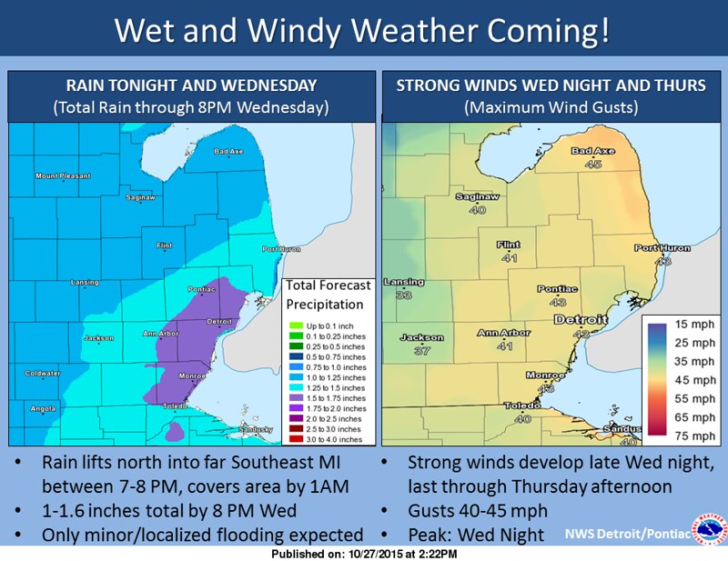
From the Det/Pon NWS:
A strong low pressure system will lift through the Great Lakes tonight through Thursday, bringing a period of wet and windy weather. Rain will spread north into Southeast Michigan between 8 PM and 1 AM tonight, and remain fairly steady through Wednesday morning. Steadier rain will then taper off to showers, which will last through Thursday evening. Winds will be fairly gusty tonight through Wednesday, before a cold front brings stronger winds late Wednesday night and Thursday. Peak gusts look to run between 40 and 45 mph.
Toledo Forecast:
Last Update: Oct 27, 2015 3:36 pm
Tonight: Rain, mainly after 8pm. Low around 51. East wind 13 to 15 mph. Chance of precipitation is 100%. New precipitation amounts between three quarters and one inch possible.
Wednesday: Showers, with thunderstorms also possible after noon. High near 63. Breezy, with a south wind 18 to 21 mph, with gusts as high as 31 mph. Chance of precipitation is 100%. New rainfall amounts between a half and three quarters of an inch possible.
Wednesday Night: A chance of showers. Cloudy, with a low around 43. Southwest wind around 18 mph, with gusts as high as 29 mph. Chance of precipitation is 50%. New precipitation amounts of less than a tenth of an inch possible.
Thursday: A slight chance of showers before noon. Mostly cloudy, with a high near 49. Windy, with a west wind 20 to 26 mph, with gusts as high as 39 mph. Chance of precipitation is 20%.
At the moment, those forecast winds are below the Wind Advisory level, which is defined as:
Wind Advisory: Issued when sustained winds are expected to be 31 - 39 mph for at least an hour, or any wind gust between 46 and 57 mph.
On Tuesday afternoon, however, the Cle NWS hinted at the possibility that winds could be stronger on Thursday than what's forecast now.
850 mb winds will be in excess of 40 knots so there is a potential for wind advisory type winds [on Thu]. since we have so much weather to get through before thursday ... will hold off on any sort of headlines for now.
For mariners ...
On Lake Superior:
A gale watch remains in effect from Thursday morning through
Thursday evening.Wind and waves during the gale watch: expect sustained winds of up to 36 knots from the northwest... with gusts up to 45 knots. The largest expected significant waves will be 16 feet with a maximum wave height of up to 23 feet possible.
At the eastern end of Lake Erie:
Gale Warning in effect from 4 am to 4 PM EDT Wednesday.Gale watch in effect from late Wednesday night through Thursday evening.
Winds... southeast winds will increase to 35 to 40 knot gales late tonight into Wednesday. Winds will decrease late Wednesday afternoon to 20 to 25 knots. Winds will likely reach gale force again on Thursday with the passage of a strong cold front.
Waves/seas... waves in the open waters will build to 7 to 12 feet on Wednesday. Waves will decrease to 5 to 9 feet Wednesday night then increase to 10 to 14 feet on Thursday.
From JR's : articles
821 words - 4809 chars
- 4 min read
created on
- #
source
- versions
Related articles
Severe weather threat for Sun, Nov 17, 2013 - Nov 18, 2013
Nov 17, 2013 Toledo area weather notes - Mar 03, 2014
Posts related to Nov 17, 2013 severe weather - Nov 21, 2013
Toledo area weather for early December 2013 - Dec 05, 2013
Mon, Dec 9, 2013 winter storm forecast for Sat, Dec 14 - Dec 14, 2013
more >>