Toledo weather - tue, apr 26, 2016
special weather statement
national weather service cleveland oh
117 am edt tue apr 26 2016
ohz003-006>008-260630-
lucas-wood-ottawa-sandusky-
including the cities of...toledo...bowling green...port clinton...
fremont
117 am edt tue apr 26 2016
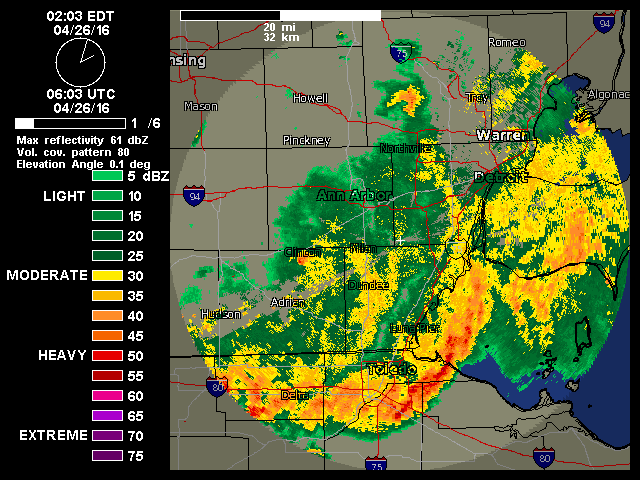
an line of showers and thunderstorms will spread southeast into
parts of northwest ohio early this morning. the thunderstorms will
reach a line from bowling green to port clinton by 2 am. wind
gusts to 45 mph can be expected with the thunderstorms. brief
heavy rain and some small hail will also be possible.
! posted by jr on Apr 26, 2016 at 01:32:24 am # + ' '
Earlier statement for Monroe and Lenawee counties.
Special Statement
Issued: 12:56 AM EDT Apr. 26, 2016 – National Weather Service
... Significant weather advisory for Monroe and Lenawee counties until
200 am EDT...
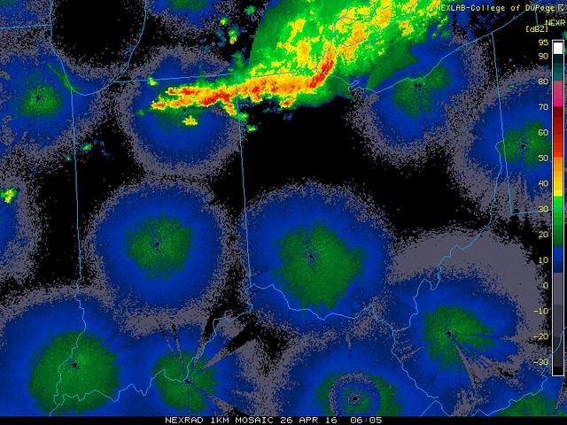
At 1254 am EDT... Doppler radar indicated line of strong thunderstorms
along a line extending from 6 miles southwest of Manchester to near
Clayton to 7 miles northwest of Pioneer. Movement was east at 50 mph.
Hail up to one half an inch in diameter and wind gusts up to 50 mph
will be possible with these storms.
Strong thunderstorms will be near...
Clayton around 100 am EDT.
Adrian and Tecumseh around 105 am EDT.
Britton around 110 am EDT.
Blissfield around 115 am EDT.
Milan... Dundee... Morenci... Petersburg... Deerfield and Ottawa Lake
around 120 am EDT.
Maybee around 125 am EDT.
Temperance and Ida around 130 am EDT.
Monroe... Carleton and Luna Pier around 135 am EDT.
Other locations impacted by these storms include Manitou Beach...
Ridgeway... Samaria... Springville... Azalia... Tipton... Munson...
Palmyra... Riga and Estral Beach.
Precautionary/preparedness actions...
Torrential rainfall is also occurring with these storms... and may lead
to localized flooding. Do not drive your vehicle through flooded
roadways.
! posted by jr on Apr 26, 2016 at 01:34:51 am # +
Marine Warning
Issued: 1:34 AM EDT Apr. 26, 2016 – National Weather Service
The National Weather Service in Cleveland has issued a
- special marine warning for...
nearshore waters from Maumee Bay OH to the islands...
open waters from Maumee Bay OH to the islands OH...
- until 230 am EDT
- at 133 am EDT... a line of strong thunderstorms... was located along
a line extending from 7 nm northwest of Luna Pier to 23 nm
southwest of North Cape... moving east at 40 knots.
Hazard... wind gusts to 40 knots.
Source... radar indicated.
Impact... overturned and capsized boats.
- Locations impacted include...
Put-In-Bay and Reno Beach.
Precautionary/preparedness actions...
Frequent lightning is occurring with these storms. If caught on the
open water stay below deck if possible... keep away from ungrounded
metal objects.
Lat... Lon 4172 8346 4172 8341 4182 8330 4195 8312
4194 8310 4192 8310 4186 8306 4170 8272
4140 8294 4143 8309 4156 8309 4169 8347
time... Mot... loc 0533z 274deg 46kt 4190 8356 4153 8386
Hail... 0.00in
wind... 40kts
Clark
2:14 a.m. post:
it appears that the most of the moderate-to-heavy rain that is moving through now and will move through later will occur south of sylvania ave. soggy morning in southern lucas county and northern wood county. rain is moving east-southeast.
From JR's : articles
521 words - 3335 chars
- 2 min read
created on
updated on
- #
- replies: 19
source
- versions
Related articles
Severe weather threat for Sun, Nov 17, 2013 - Nov 18, 2013
Nov 17, 2013 Toledo area weather notes - Mar 03, 2014
Posts related to Nov 17, 2013 severe weather - Nov 21, 2013
Toledo area weather for early December 2013 - Dec 05, 2013
Mon, Dec 9, 2013 winter storm forecast for Sat, Dec 14 - Dec 14, 2013
more >>