You're viewing old version number 2. - Current version
Toledo Weather - Mon, Jun 6, 2016
This morning, the Marginal Risk as a little below Toledo. Late this morning, the Marginal Risk included Toledo and southeast Michigan.
Now the SPC may upgrade the risk to Slight.
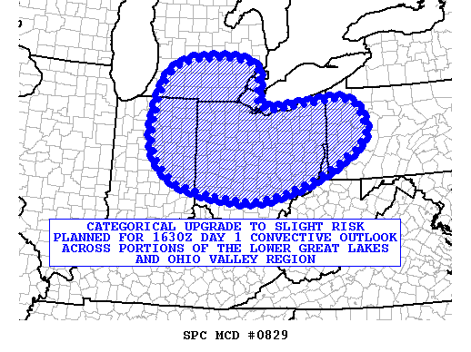
md 0829 concerning outlook upgrade for portions of the lower great lakes and ohio valley region
mesoscale discussion 0829
nws storm prediction center norman ok
1041 am cdt mon jun 06 2016
areas affected...portions of the lower great lakes and ohio valley
region
concerning...outlook upgrade
valid 061541z - 061645z
summary...a categorical upgrade to slight risk is being planned for
the 1630z day 1 convective outlook...for portions of the lower great
lakes and ohio valley region. clusters of fast-moving thunderstorms
with damaging wind gusts will likely move across the area this
afternoon.
discussion...the latest observational data and short-range model
guidance offer increasing confidence that fast-moving convective
clusters will have the potential to produce dmgg wind gusts across
portions of the lower great lakes and ohio valley region this
afternoon. this activity will be in association with a vigorous
upper-level disturbance approaching the area from the wnw...ahead of
which a destabilizing air mass will exist amidst strong deep-layer
flow. additional meteorological reasoning for the upgrade will be
provided in the forthcoming day 1 convective outlook.
..cohen/weiss/bunting.. 06/06/2016
...please see www.spc.noaa.gov for graphic product...
attn...wfo...pbz...rlx...cle...iln...dtx...iwx...grr...ind...
lat...lon 41568262 41727994 41287933 40657937 39788087 39258290
39588525 40288613 41278623 42508565 42808418 42588284
41568262
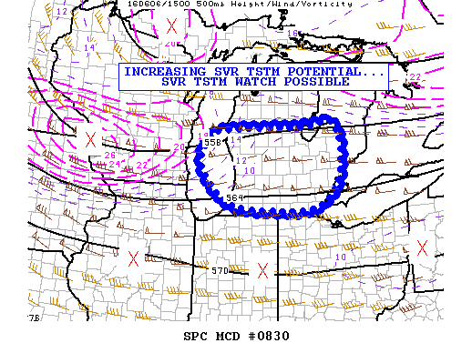
md 0830 concerning severe potential...watch possible for portions of cntrl and srn lower michigan and lake michigan
mesoscale discussion 0830
nws storm prediction center norman ok
1118 am cdt mon jun 06 2016
areas affected...portions of cntrl and srn lower michigan and lake
michigan
concerning...severe potential...watch possible
valid 061618z - 061845z
probability of watch issuance...60 percent
summary...fast-moving tstms with dmgg-wind potential will likely
move across the area this afternoon...and the issuance of a severe
thunderstorm watch may be required early this afternoon.
discussion...organized convection has already developed across
portions of e-cntrl wi immediately in advance of a mid-level vort
max orbiting around the swrn rim of a deep cyclone centered over wrn
quebec. forward extrapolation of the vort max takes it on a path
reaching near detroit around 20z/21z and near cleveland ohio around
22z/23z. this suggests that dcva will spread across the region near
and prior to peak heating. despite only limited low-level moisture
available -- e.g. dewpoints in the lower/middle 50s -- steepening
low/mid-level lapse rates with adiabatic cooling aloft related to
the dcva will support sufficient buoyancy for tstm intensification
this afternoon.
upstream vwps at grb and mkx sample deep unidirectional flow with
wlys at 30-45 kt through the lower/middle portion of the convective
layer. this kinematic profile supporting elongated straight
hodographs...combined with ample high-level flow enhancing
convective ventilation...suggests that splitting tstms and
fast-moving convective clusters will likely spread across the region
during the afternoon hours. the relatively dry thermodynamic
profiles will encourage evaporational cooling to accelerate
downdrafts and convective momentum transport...facilitating the
potential for dmgg wind gusts. isolated svr hail may also occur
given cooling profiles aloft and anticipated splitting tstms. there
is some uncertainty regarding the timing of the more robust increase
in svr potential which extends to possible ww issuance...though the
svr risk will likely increase this afternoon.
..cohen/weiss.. 06/06/2016
...please see www.spc.noaa.gov for graphic product...
attn...wfo...dtx...apx...iwx...grr...
lat...lon 41918563 42188665 42988734 43738706 43888646 43928554
43958380 44008281 42748269 41938351 41918563
From JR's : articles
553 words - 4073 chars
- 3 min read
created on
updated on
- #
source
- versions
Related articles
Severe weather threat for Sun, Nov 17, 2013 - Nov 18, 2013
Nov 17, 2013 Toledo area weather notes - Mar 03, 2014
Posts related to Nov 17, 2013 severe weather - Nov 21, 2013
Toledo area weather for early December 2013 - Dec 05, 2013
Mon, Dec 9, 2013 winter storm forecast for Sat, Dec 14 - Dec 14, 2013
more >>