Toledo Weather - Tue, Jun 7, 2016
TOL:
Jun 7, 2016 7:52 am
Weather : Fair
Temperature : 58 F
Humidity : 78%
Wind Speed : WNW 9 mph
Barometer : 29.71 in
Dewpoint: 51 F
Visibility : 10.00 statute miles
Toledo 7-day forecast
Last Update: Jun 7, 2016 6:05 am
Today: A slight chance of showers, with thunderstorms also possible after 3pm. Mostly cloudy, with a high near 65. Northwest wind 11 to 17 mph. Chance of precipitation is 20%.
Tonight: A slight chance of showers and thunderstorms before 8pm, then a slight chance of showers between 8pm and midnight. Mostly cloudy, then gradually becoming mostly clear, with a low around 45. Northwest wind 8 to 15 mph. Chance of precipitation is 20%.
Wednesday: Sunny, with a high near 69. Northwest wind 11 to 16 mph.
Wednesday Night: Mostly clear, with a low around 47. West wind 5 to 14 mph.
Thursday: Mostly sunny, with a high near 74. Calm wind becoming west around 6 mph in the afternoon.
Thursday Night: A slight chance of showers and thunderstorms. Mostly cloudy, with a low around 57. Chance of precipitation is 20%.
Friday: A chance of showers and thunderstorms. Partly sunny, with a high near 81. Chance of precipitation is 30%.
Friday Night: Mostly cloudy, with a low around 63.
Saturday: A chance of showers and thunderstorms. Partly sunny, with a high near 87. Chance of precipitation is 40%.
Saturday Night: A chance of showers and thunderstorms. Partly cloudy, with a low around 62. Chance of precipitation is 30%.
Sunday: Mostly sunny, with a high near 79.
Sunday Night: Partly cloudy, with a low around 60.
Monday: Mostly sunny, with a high near 80.
fxus61 kcle 071128
afdcle
area forecast discussion
national weather service cleveland oh
728 am edt tue jun 7 2016
synopsis...
a cold front will move south of the area this morning. a ridge of
high pressure extending south from the north pole will shift
gradually east out of the mississippi valley region through
thursday. the high pressure will move east of the area friday as a
warm front lifts northeast across the area saturday.
&&
near term /until 6 pm this evening/...
upper level trough and surface cold front pushing southeast across
the area at this time. clouds will continue to develop across the
area today and more clouds will push southeast into the area this
afternoon from the north. still expecting showers and then
thunderstorms to develop today as strong cold air advection takes
place. no major changes with this update.
previous discussion...
a strong cold front will move southeast and out of the area today
ushering in much colder air to the forecast area today. models
suggest some wrap around moisture will move southeast into the
region today and with the cold air advection over the lakes, some
lake effect/lake enhanced showers are possible. due to the
instability over the eastern half of the forecast area, some
thunderstorms are possible as well. skies are currently mostly clear
but expect cumulus to quickly form during the morning across the
area after sunrise. so, partly sunny should cover it this morning
with increasing clouds for the afternoon. the strong cold air
advection will take place today and i think highs will be much
cooler as well. nam model was much warmer than the rest of the
models and will lean toward the colder highs in the middle to upper
60s most areas.
&&
short term /6 pm this evening through friday night/...
strong cold air advection continues tonight through wednesday as
high pressure remains in control at the surface. large
amplification of the ridge in the west will keep troughiness in the
eastern half of the united states and hence the cold air advection
pattern we are experiencing.
the upper level ridge will keep building east across the central
united states and shift east toward the forecast area by saturday.
this should gradually bring an end to the cold air advection and a
return back to warm air advection for the weekend.
in the mean time, expecting scattered showers to gradually taper off
into a lake effect scenario by tuesday night into wednesday morning.
as the high pressure eventually shifts east, threat for showers will
come to an end and winds will go light and variable by thursday. a
warm front will begin to approach the area friday into friday night.
cool temperatures in the 60s will take place wednesday with lows in
the 40s tonight and wednesday night. a recovery will begin by
thursday.
&&
long term /saturday through monday/...
big changes to the long term as the remnants of the tropical system
over fl will merge with a system diving southeast out of canada.
this means a strong cold front will be driven southwest across the
region on sunday. the gfs is colder than the ecmwf but even it has
850 mb temps down to plus 6 or 7 across the eastern end of the area
by 00z monday. showers and storms still look probable for saturday
as the front approaches. precip chances will continue into saturday
night but high pressure off to the northwest will dry things out by
late sunday. the earlier talk of upper 80s for sunday is over and
have lowered highs into the 70s. if current trends continue these
numbers will need to be lowered further. monday also looks cool but
dry.
&&
aviation /12z tuesday through saturday/...
most of the area remains clear but that is about to change. have
been watching the large area of stratus/strato cu approach from
the northwest. the big question is whether we will have to wait
for these clouds to arrive or if new clouds will develop from the
cold air advection over the lake. suspect that a combination of
the two will occur and will bring in cigs the next few hours.
given the upstream obs have expanded the amount of mvfr cigs. the
clouds over mi are ifr in many spots but do not expect that to
happen here. by early afternoon some instability showers will
begin to develop downwind of the lake. will go with a combination
of tempos and vicinities for a few hours in the afternoon. winds
have become westerly most areas and should switch to wnw in a
couple of hours. gusts in the 20 to 25 knot range are likely
through late afternoon. will try to lift cigs back to vfr later
today but that may be optimistic.
outlook...non vfr possible friday night and saturday in
showers/thunderstorms.
&&
marine...
wnw to nw winds will be picking up this morning as a cold front
pushes off to the east. will see small craft conditions quickly
develop this morning along with dangerous swimming conditions. nw
flow will continue till a surface ridge crosses the lake on thursday
night. winds will take on a southerly component at that time. a
warm front will follow sometime friday night. a very strong cold
front will be just to the north of the area at the end of the
period.
&&
cle watches/warnings/advisories...
oh...beach hazards statement through wednesday evening for
ohz010>012-089.
pa...beach hazards statement through wednesday evening for paz001.
marine...small craft advisory until 10 pm edt wednesday for lez145>149.
small craft advisory until 4 pm edt wednesday for lez142>144.
&&
$$
synopsis...lombardy
near term...lombardy
short term...lombardy
long term...kubina
aviation...kubina
marine...kubina
The Storm Prediction Center continues to forecast a severe weather threat for Saturday, June 11.
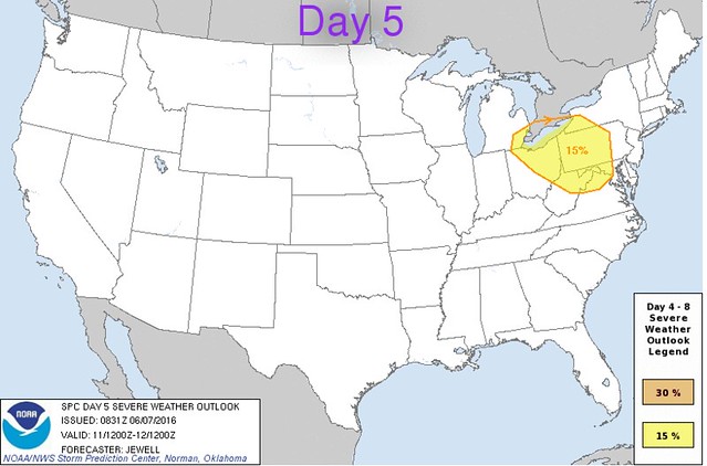
the forecast appeared in yesterday's Day 6 outlook except now the area has been slightly expanded to the west to include all of toledo.
From JR's : articles
1255 words - 7418 chars
- 6 min read
created on
updated on
- #
source
- versions
Related articles
Severe weather threat for Sun, Nov 17, 2013 - Nov 18, 2013
Nov 17, 2013 Toledo area weather notes - Mar 03, 2014
Posts related to Nov 17, 2013 severe weather - Nov 21, 2013
Toledo area weather for early December 2013 - Dec 05, 2013
Mon, Dec 9, 2013 winter storm forecast for Sat, Dec 14 - Dec 14, 2013
more >>