Toledo Weather - Tue, Jun 14, 2016
Amazing weather today: mostly cloudy to cloudy, light wind, dry, temps in the 70s. no need for a fan indoors. windows up. i could hear the birds sing, including the EAWP that sang throughout the day around our home from shortly after 6:00 a.m. to around 8:45 p.m.
TOL: Jun 14, 2016 9:52 pm
Weather : Partly Cloudy
Temperature : 66 F
Humidity : 59%
Wind Speed : E 6 mph
Barometer : 29.95 in
Dewpoint: 51 F
Visibility : 10.00 statute miles
Tol: Jun 14, 2016 12:52 pm
Weather : Fair
Temperature : 76 F
Humidity : 37%
Wind Speed : ESE 7 mph - Gust 17 mph
Barometer : 29.99 in
Dewpoint: 48 F
Visibility : 10.00 statute miles
External Link : 3-day history
Great weather. Cloudy to mostly cloudy. Light wind. Comfy.
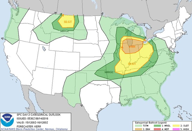
This morning, the SPC's Day 2 Convective Outlook shows the Toledo area under an Enhanced Risk for severe weather for tomorrow, June 15. We are in the eastern edge of the Enhanced Area. The Slight Risk continues to cover all of the rest of Ohio, except for the extreme corner of northeast Ohio.
The best chance for severe weather tomorrow may be northern Indiana and southwest Michigan.
hazardous weather outlook
national weather service cleveland oh
419 am edt tue jun 14 2016
ohz003-007-009-150830-
lucas-ottawa-erie-
419 am edt tue jun 14 2016
this hazardous weather outlook is for north central ohio and
northwest ohio.
.day one...today and tonight.
there is a moderate risk or rip currents this afternoon and
evening at lake erie beaches in lucas...ottawa...and erie county ohio.
.days two through seven...wednesday through monday.
thunderstorms are expected to develop wednesday afternoon and
evening. some of the storms may be strong to severe...with the
potential for downburst winds and large hail.
.spotter information statement...
spotter activation is not expected at this time.
spc ac 140536
day 2 convective outlook
nws storm prediction center norman ok
1236 am cdt tue jun 14 2016
valid 151200z - 161200z
...there is an enh risk of svr tstms late wednesday afternoon and
evening across southern portions of the great lakes region...
...there is a slgt risk of svr tstms across surrounding areas of the
upper midwest and southern great lakes region into the ohio and
middle mississippi valleys...
...there is a slgt risk of svr tstms across parts of central and
eastern montana...
...there is a mrgl risk of svr tstms surrounding the slight risk
area across the upper midwest/southern great lakes region into
ohio/middle mississippi valleys and ozark plateau region...
...there is a mrgl risk of svr tstms surrounding the slight risk
area across parts of the northern rockies and northern plains...
...summary...
severe storms are expected wednesday into wednesday night across
parts of the upper midwest and southern portions of the great lakes
region...into the ohio and middle mississippi valleys.
...synopsis...
within the main belt of westerlies...some further amplification of
large-scale upper troughing appears possible during this
period...near or just west of the u.s. pacific coast. this is
expected to occur as a significant short wave trough and embedded
closed low slowly dig toward the oregon/northern california shore.
meanwhile...a significant preceding impulse appears likely to slowly
migrate north of the western canadian prairies. in between these
features...a smaller-scale impulse may turn inland of the northern
pacific coast...and northeastward into/through the northern rockies.
downstream...models indicate that ridging will continue to build
from the lee of the central rockies through the hudson bay region.
just to the east of this feature...troughing reaching the upper
mississippi valley by 12z wednesday is expected to gradually turn
southeastward across the upper midwest and southern great lakes
region. at the same time...much more prominent upper
troughing...and a broad embedded closed low centered over the
canadian maritimes...may only slowly shift eastward.
a low-level frontal zone associated with this latter feature is
expected to linger across parts of the mid atlantic coast and
central appalachians...into the southern great lakes region and
upper midwest...where a frontal wave is expected to migrate
southeastward with the upper impulse initially over the upper
mississippi valley. the portion of the front trailing the wave is
expected to eventually stall...before perhaps beginning to redevelop
northward across the middle missouri valley and northern high
plains...ahead of another frontal zone extending across the northern
rockies southward through the great basin.
...upper midwest/srn great lakes region into oh/ms valleys...
within the warm sector of the surface low...seasonably high surface
dew points in the mid/upper 60s and 70s f are expected to contribute
to cape on the order of 2000-3000+ j/kg by peak heating wednesday.
this is expected with insolation...beneath initially modestly steep
mid-level lapse rates associated with the remnants of a plume of
elevated mixed layer air.
although much of the middle mississippi into ohio valleys may come
under the influence of weak lower/mid-level subsidence during the
day...inhibition may become weak enough beneath at least broadly
cyclonic mid/upper flow to allow for scattered areas of storm
development. perhaps aided by shear associated with 20-30 kt mean
west/northwesterly mid-level flow...activity could grow upscale into
organizing storm clusters...accompanied by potentially damaging wind
gusts and perhaps some severe hail.
more substantive potential for organized severe storm development
may evolve in closer proximity to the surface low...from parts of
southeastern wisconsin into northern illinois by late afternoon.
this probably will be supported by forcing for ascent associated
with low-level warm advection...just ahead of the mid-level impulse
which may be accompanied by a 40-50 kt 500 mb speed maximum. a
couple of supercells may not be out of the question
initially...before upscale growth into a forward/southeastward
propagating convective system occurs. damaging surface gusts may
become the most prominent severe threat as activity propagates
across northeastern illinois/northern indiana and southern michigan
wednesday evening.
...northern rockies/northern plains...
warming elevated mixed layer air may spread north of the
rockies...through much of eastern montana...by late wednesday night.
this is expected to occur above a moistening pre-frontal boundary
layer...which may contribute to cape of 1000-2000 j/kg during the
day wednesday. if sustained storm development does not occur off
the higher terrain of montana during the peak daytime heating...an
area of increasing warm advection...on the nose of a southerly 850
mb jet strengthening to around 50 kt...is expected to support storms
wednesday evening. a couple of supercells appear
possible...accompanied by the risk for large hail and perhaps a
tornado or two.
..kerr.. 06/14/2016
click to get wuus02 ptsdy2 product
note: the next day 2 outlook is scheduled by 1730z
Toledo 7-day forecast
Last Update: Jun 14, 2016 6:13 am
Today: A chance of rain before noon, then isolated showers and thunderstorms after 3pm. Cloudy, with a high near 80. East wind 7 to 9 mph. Chance of precipitation is 20%.
Tonight: A chance of showers and thunderstorms, mainly after 10pm. Cloudy, with a low around 63. East wind 6 to 10 mph. Chance of precipitation is 30%. New rainfall amounts of less than a tenth of an inch, except higher amounts possible in thunderstorms.
Wednesday: Showers and thunderstorms likely, mainly after 1pm. Cloudy, with a high near 83. South wind 6 to 8 mph. Chance of precipitation is 70%. New rainfall amounts between a quarter and half of an inch possible.
Wednesday Night: A chance of showers and thunderstorms. Mostly cloudy, with a low around 66. Light and variable wind. Chance of precipitation is 50%. New rainfall amounts between a quarter and half of an inch possible.
Thursday: A chance of showers and thunderstorms. Cloudy, with a high near 80. West wind 5 to 13 mph. Chance of precipitation is 40%. New rainfall amounts of less than a tenth of an inch, except higher amounts possible in thunderstorms.
Thursday Night: A slight chance of showers. Mostly cloudy, with a low around 62. Chance of precipitation is 20%.
Friday: Sunny, with a high near 80.
Friday Night: Clear, with a low around 58.
Saturday: Sunny, with a high near 84.
Saturday Night: Mostly clear, with a low around 59.
Sunday: Sunny, with a high near 87.
Sunday Night: Mostly clear, with a low around 64.
Monday: Mostly sunny, with a high near 87.
area forecast discussion
national weather service cleveland oh
752 am edt tue jun 14 2016
synopsis...
high pressure over the eastern lakes will move off the east coast
wednesday...allowing a warm front to lift across the forecast area.
a low pressure system will slide se across the area thursday. high
pressure will build over the area early friday.
&&
near term /until 6 pm this evening/...
no significant changes for the 630 update.
original discussion...
a mid level cloud deck will linger over the forecast area today.
models trying to show some showers in the west this morning...but
with cloud decks 6k+ will just mention a chance of sprinkles in
the west this morning. did leave a mention of isolated tsra in the
west late this afternoon. capes only reach 500 j/kg this afternoon
and upper level ridge still intact...but could see a few tsra
develop to the west and make it into nw oh late. as far as temps
still in the "cool" sector...so tweaked yesterdays highs a couple
of degrees for todays high temps.
&&
short term /6 pm this evening through friday night/...
models continue to move high pressure centered over the lakes east
to the coast on wednesday. this will set up an unsettled pattern
wednesday into thursday. the warm front...currently stretching
across illinois into sw indiana...moves over the forecast area
wednesday. this will usher in hot and humid conditions. went lower
to mid 80s for highs...however...if front faster than forecast
and more sun than anticipated could see mid to upper 80s.
spc has most of ohio in slight risk for severe tsra late wednesday
afternoon and evening. upper level ridge finally breaks down and capes
in the west approach 2500 j/kg late afternoon. there is also a
weak ll jet developing toward evening...as the 925mb winds
increase to 35 kt. will also be aided by a little lift from weak
300mb jet. tsra expected to develop in the west late afternoon and
move across the forecast area during the evening.
models continue to develop low pressure system that moves se across
the forecast area on thursday. finally high pressure builds over
the area on friday setting up a sunny and dry weekend.
&&
long term /saturday through monday/...
pleasant weekend on the way with high pressure overhead ensuring a
dry forecast. upper level ridge axis will be over the great lakes
region on saturday, shifting towards new england on sunday.
temperatures will be near seasonal norms with low humidity to start
the weekend, with a warming trend setting up into monday as
southwesterly flow and warm advection develops. by monday most areas
will be in the mid 80s with northwest ohio pushing the upper 80s.
the 00z/14 gfs is on the fast side of the long range models in
breaking down the upper level ridge with a cold front moving through
on monday. the gfs ensemble mean is also slower than the operational
run so will keep monday dry for now and introduce a low pop by
monday night.
&&
aviation /12z tuesday through saturday/...
high pressure will remain over the eastern great lakes through the
taf cycle with vfr conditions expected. regional radars show showers
with scattered thunderstorms moving east across indiana. these will
tend to weaken as they move eastward into the drier air but could
reach fdy early this afternoon before falling apart. conditions will
be vfr with sct-bkn clouds near 6-8k feet. a few light showers will
return after 06z tonight, mainly at the western and central
terminals. winds will be 10 knots or less out of the east except
northeast at cle/eri with lake breezes developing this afternoon.
tol may occasionally gust to 15-20 knots this afternoon as the
lake breeze enhances the easterly flow.
outlook...non vfr at times in showers and thunderstorms wednesday
and thursday.
&&
marine...
high pressure over the eastern great lakes will maintain an easterly
flow on lake erie. winds on the west end of the lake will increase
to 15-20 knots for a period this afternoon which will result in
waves building to 2 to 4 feet into this evening. the onshore flow
and higher waves will also suggest a moderate swimming risk for
today west of vermilion. easterly winds will continue on wednesday
but are expected to be at or below 15 knots.
a low pressure system will slide southeast across lake erie
wednesday night and thursday with winds shifting around before
finally setting up out of the north or northeast by thursday night.
northeast winds of 15-20 knots may require a small craft advisory
and elevated swimming risk. high pressure will build over the lake
next weekend with light winds leading to good boating conditions.
&&
cle watches/warnings/advisories...
oh...none.
pa...none.
marine...none.
&&
$$
synopsis...djb
near term...djb
short term...djb
long term...kec
aviation...kec
marine...kec/sefcovic
From JR's : articles
2140 words - 13463 chars
- 11 min read
created on
updated on
- #
source
- versions
Related articles
Severe weather threat for Sun, Nov 17, 2013 - Nov 18, 2013
Nov 17, 2013 Toledo area weather notes - Mar 03, 2014
Posts related to Nov 17, 2013 severe weather - Nov 21, 2013
Toledo area weather for early December 2013 - Dec 05, 2013
Mon, Dec 9, 2013 winter storm forecast for Sat, Dec 14 - Dec 14, 2013
more >>