Toledo Weather - Wed, Jun 15, 2016
JustaSooner at TT. images included with the post. if storms don't fall apart, then we may encounter thunder between 5 and 7 a.m.
-----
New watch possible for Lower MI soon. Slight Risk extended to cover Southern MI from Lake Michigan through all of SE MI.
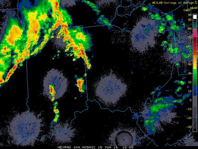
Update for MI, OH, and IN 949PM EDT -- Complex of storms has moved completely over Lake Michigan. Radar imagery suggests several areas where waterspouts could be ongoing as this activity moves over. Movement is roughly ESE at 40 mph. The first part of the complex is moving into Mason and Oceana counties north of Muskegon. The leading edge of the storms should be into the Grand Rapids metro area with an hour, Lansing Metro in 2 hours...Ann Arbor/Detroit Metro area in about 3.5-4.5 hours. The southern edge of the complex, or the tail end charlie, will track further south...Kalamazoo/Battle Creek area in 2.5 hours...and then Toledo metro area in 5-6 hours. Any increase in forward speed of course would impact arrival times. There is also a good chance these will weaken and fall apart due to the upper levels starting to cool and CINH increasing.
Main threats will be winds to 70, hail to 1 inch, and a couple tornadoes with in the first couple rows of counties after making landfall. Risk should then move to a damaging wind threat further inland. HRRR does highlight that tail end charlie storm as one to watch for possible enhanced helicity and better chance to be rotating. Can't rule out a tornado with that one, but the risk is very low as it appears.
Again, all of this could fall apart pretty quickly, but if not just keep an eye out. Make sure your weather radio is on as these will be coming through many populated areas through the overnight.
posted by JustaSooner on Jun 15, 2016 at 10:00:50 pm
comment at TT:
Front has stalled out just southwest of the metro area. This could alter the storm track and the latest HRRR is picking up on this. Will need to monitor to see if there is going to be the trend, and if so a revision to the overnight forecast will be needed. This might include increasing the severe risk overnight and including all modes of severe weather as possibilities.
! posted by JustaSooner on Jun 15, 2016 at 08:25:23 pm
TOL: Jun 15, 2016 5:52 pm
Weather : Mostly Cloudy
Temperature : 88 F
Humidity : 48%
Wind Speed : WSW 8 mph
Barometer : 29.73 in
Dewpoint: 66 F
Visibility : 10.00 statute miles
Heat Index : 90 F
TOL: Jun 15, 2016 4:52 pm
Weather : Partly Cloudy
Temperature : 86 F
Humidity : 55%
Wind Speed : W 10 mph
Barometer : 29.74 in
Dewpoint: 68 F
Visibility : 10.00 statute miles
Heat Index : 89 F
(formerly Metcalf Airport)
Jun 15, 2016 4:53 pm
Weather : Partly Cloudy
Temperature : 88 F
Humidity : 45%
Wind Speed : WNW 13 mph - Gust 20 mph
Barometer : 29.75 in
Dewpoint: 64 F
Visibility : 10.00 statute miles
Heat Index : 89 F
sticky afternoon. temps in the upper 80s to around 90 in some spots. dew points near 70.
(near Lambertville)
Jun 15, 2016 4:35 pm
Weather : Mostly Cloudy
Temperature : 89 F
Humidity : 50%
Wind Speed : WSW 6 mph
Barometer : 29.75 in
Dewpoint: 68 F
Visibility : 10.00 statute miles
Heat Index : 93 F
area forecast discussion
national weather service cleveland oh
315 pm edt wed jun 15 2016
synopsis...
a warm front will lift north and through the region tonight. an
area of low pressure will move in from the northwest and cross the
area on thursday bringing showers and thunderstorms. this will be
followed by high pressure for friday and into the weekend.
&&
near term /until 6 am thursday morning/...
the capped airmass in place over the area is inhibiting late
afternoon convection (h700 temperatures around 8c). skies have
broken over most of the western counties with temperatures in the
80s in many areas. highest temperature readings have been at
cle where some added downslope and break in the clouds have
pushed temps to 88f. the dew points have jumped to around 70f in
the west as the warm front moves into the area. the storm
prediction center still has a large portion of the area in a
slight risk for severe weather. the forecast shear values appear
marginal however the high capes could be sufficient for severe
mainly in the west. forecast soundings indicate the potential for
the cap to break around 20z- 22z. the eastern half of the forecast
area has been insulated by the clouds and still has dew points in
the 50s, which will keep out any threat for strong/severe storms.
in the west the best chance for strong storms will be if any
development upstream and advects in before 00z. have isolated
showers in the east and a brief window of scattered showers and
thunderstorms in the west. overall have downplayed the potential
convection given the strong cap and limited area of high
instabilities in the area. there will lull in activity as weak
subsidence move in overnight. meanwhile, an area of low pressure
will move towards the area from the northwest, increasing rain
chances by thursday morning. temperatures will cool very little
overnight as the warm front and moisture advection prevent lows
from dipping much below 70. in the east temperatures could cool
early and then warm before daybreak.
area forecast discussion
national weather service detroit/pontiac mi
336 pm edt wed jun 15 2016
discussion...
the focus over the next 24-36 hours is on the track of the upper
level low/cold pool (-12 c at 500 mb) currently centered over/near
the western tip of lake superior. mid level dry slot and warming out
ahead of this feature is expected to limit convective activity for
the rest of the day into this evening, as we struggle to bypass low
level cap. even with the 12z nam indicating more reasonable dew pts
around 70 degrees, and mlcapes around 2000 j/kg late today, no
qpf/convection is indicated. however, will still hold onto isolated
severe threat if any enhanced low level convergence allows a cell or
two to go up, as cape and 0-6 km remains substantial with still
areas of backed surface flow.
good forcing/height falls will overspread southeast michigan
overnight into tomorrow morning, which is expected to support a good
coverage of showers and thunderstorms. mid level lapse rates (700-
500 mb) are weak, mostly under 6 c/km, so chances for severe are
quite low after midnight as daytime surface/low level instability
wanes, except toward the ohio border where low level moisture
advection/pooling looks to be maximized as nose of 35 knot low level
jet pushes through in the 7-12z time frame.
the circulation at the surface and aloft will track through
southeast michigan tomorrow. mucapes less than 1000 j/kg will
support a chance of non-severe thunderstorms. still sufficient
moisture (pw values 1.5+ inches) and deep warm layer to support
heavy rainfall, especially on northeast flank of the circulation.
pronounced upper level ridge remains on track to build into the
central great lakes friday-saturday, as 500 mb heights increase to
around 590 dam. low level northeast flow emitting from surface high
over eastern great lakes will keep humidity levels on the low side
for june standards and mute the warmup slightly, holding maxes in
the 80s, as temperatures rise from the morning lows in the 50s for
most part.
tornado watch over much of eastern wisconsin until 9pm edt.
http://www.spc.noaa.gov/products/watch/ww0259.html
URGENT - IMMEDIATE BROADCAST REQUESTED
TORNADO WATCH NUMBER 259
NWS STORM PREDICTION CENTER NORMAN OK
210 PM CDT WED JUN 15 2016
THE NWS STORM PREDICTION CENTER HAS ISSUED A
* TORNADO WATCH FOR PORTIONS OF
WISCONSIN
LAKE MICHIGAN
* EFFECTIVE THIS WEDNESDAY AFTERNOON AND EVENING FROM 210 PM
UNTIL 800 PM CDT.
* PRIMARY THREATS INCLUDE...
A COUPLE TORNADOES POSSIBLE
ISOLATED VERY LARGE HAIL EVENTS TO 2 INCHES IN DIAMETER POSSIBLE
ISOLATED DAMAGING WIND GUSTS TO 70 MPH POSSIBLE
SUMMARY...LOW-TOPPED THUNDERSTORMS ARE EXPECTED TO INCREASE ACROSS
CENTRAL WISCONSIN AND SUBSEQUENTLY SPREAD EAST-SOUTHEASTWARD TOWARD
EAST-CENTRAL/SOUTHEAST WISCONSIN THROUGH THE LATE AFTERNOON AND
EVENING HOURS. MODESTLY STRENGTHENING LOW-LEVEL SHEAR AND THE
PROXIMITY OF AN UPPER LOW WILL CONTRIBUTE TO SOME TORNADO
POTENTIAL...PARTICULARLY ACROSS CENTRAL TO EAST-CENTRAL WISCONSIN
NEAR A SURFACE LOW/WARM FRONT. SEVERE HAIL AND WIND WILL ALSO BE
POSSIBLE.
THE TORNADO WATCH AREA IS APPROXIMATELY ALONG AND 45 STATUTE
MILES EAST AND WEST OF A LINE FROM 30 MILES NORTH NORTHWEST OF
RHINELANDER WISCONSIN TO 50 MILES SOUTH OF OSHKOSH WISCONSIN.
FOR A COMPLETE DEPICTION OF THE WATCH SEE THE ASSOCIATED WATCH
OUTLINE UPDATE (WOUS64 KWNS WOU9).
PRECAUTIONARY/PREPAREDNESS ACTIONS...
REMEMBER...A TORNADO WATCH MEANS CONDITIONS ARE FAVORABLE FOR
TORNADOES AND SEVERE THUNDERSTORMS IN AND CLOSE TO THE WATCH
AREA. PERSONS IN THESE AREAS SHOULD BE ON THE LOOKOUT FOR
THREATENING WEATHER CONDITIONS AND LISTEN FOR LATER STATEMENTS
AND POSSIBLE WARNINGS.
TOL: Jun 15, 2016 3:52 pm
Weather : Mostly Cloudy
Temperature : 87 F
Humidity : 53%
Wind Speed : W 15 mph
Barometer : 29.77 in
Dewpoint: 68 F
Visibility : 10.00 statute miles
Heat Index : 90 F
TOL: Jun 15, 2016 2:52 pm
Weather : Partly Cloudy
Temperature : 85 F
Humidity : 61%
Wind Speed : SW 8 mph
Barometer : 29.77 in
Dewpoint: 70 F
Visibility : 10.00 statute miles
Heat Index : 90 F
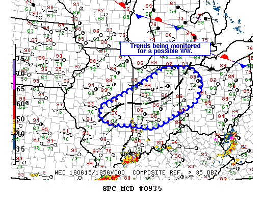
md 0935 concerning severe potential...watch possible for cntrl il...nrn/cntrl indiana...wrn oh
mesoscale discussion 0935
nws storm prediction center norman ok
0223 pm cdt wed jun 15 2016
areas affected...cntrl il...nrn/cntrl indiana...wrn oh
concerning...severe potential...watch possible
valid 151923z - 152100z
probability of watch issuance...60 percent
summary...potential for isolated dmgg wind gusts and hail appears to
be increasing across parts of cntrl il and cntrl indiana in
association with developing tstms. trends are being monitored for a
possible ww.
discussion...visible satellite trends show increasing towering cu
and isolated tstm development within a broad confluence zone across
cntrl il...and across w-cntrl/n-cntrl ind. strong heating within a
very moist boundary layer is resulting in moderate to extreme
instability /aoa 2500 j/kg/...which will support vigorous updraft
development over the next 2-3 hrs. although forcing for ascent is
generally weak...and sfc flow veered/wly...the moist and uncapped
air mass will be supportive for the development of a few multicell
clusters given 20-30 kt of effective shear...with the primary threat
being dmgg wind gusts...enhanced by the steepening of low-level
lapse rates across the area. isolated instances of svr hail are also
possible given the degree of instability...despite relatively warm
temperatures aloft. convective trends are being closely monitored
for signs of increasing tstm coverage...which could necessitate the
issuance of a new ww across parts of cntrl il...nrn/cntrl ind...and
nwrn oh this afternoon.
..rogers/guyer.. 06/15/2016
...please see www.spc.noaa.gov for graphic product...
attn...wfo...cle...iln...iwx...ind...lot...ilx...
lat...lon 41228640 41618573 41578409 41058351 40138387 39028631
39138744 39188869 39438931 39848933 40458803 41228640

Area to watch for new development is now over N IN, SW MI, and NE IL. CU developing on going and atmosphere is destabilizing nicely under plenty of heating right now. CAPE values now at or above 1500 j/kg in many areas. Expecting new storms to form in the blue area and move generally east to ESE. Main risk with storms this afternoon will be wind/hail.
! posted by JustaSooner on Jun 15, 2016 at 02:51:01 pm
http://toledotalk.com/cgi-bin/tt.pl/article/203171#203733
Partly sunny to mostly cloudy. What's the diff? Sun has been in-and-out for a while. Dew point temps were around 70 degrees at 2:00 p.m.
TOL: Jun 15, 2016 1:52 pm
Weather : Mostly Cloudy
Temperature : 81 F
Humidity : 69%
Wind Speed : SW 9 mph
Barometer : 29.79 in
Dewpoint: 70 F
Visibility : 10.00 statute miles
Heat Index : 84 F
hazardous weather outlook
national weather service cleveland oh
1232 pm edt wed jun 15 2016
lez142>145-162>165-ohz003-006>010-017>020-027>031-036>038-047-161645-
lake erie nearshore waters from maumee bay to reno beach oh-
lake erie nearshore waters from reno beach to the islands oh-
lake erie nearshore waters from the islands to vermilion oh-
lake erie nearshore waters from vermilion to avon point oh-
lake erie open waters from maumee bay to reno beach oh-
lake erie open waters from reno beach to the islands oh-
lake erie open waters from the islands to vermilion oh-
lake erie open waters from vermilion to avon point oh-lucas-wood-
ottawa-sandusky-erie-lorain-hancock-seneca-huron-medina-wyandot-
crawford-richland-ashland-wayne-marion-morrow-holmes-knox-
1232 pm edt wed jun 15 2016
this hazardous weather outlook is for lake erie...north central
ohio...northeast ohio and northwest ohio.
.day one...this afternoon and tonight.
thunderstorms are expected to develop later today. there is a
slight chance that some storms could become severe with the
potential to create large hail and damaging winds.
.days two through seven...thursday through tuesday.
no hazardous weather is expected at this time.
.spotter information statement...
spotter activation is not expected at this time.
spc ac 151640
day 1 convective outlook
nws storm prediction center norman ok
1140 am cdt wed jun 15 2016
valid 151630z - 161200z
...there is a slgt risk of svr tstms across wi/mi...
...there is a slgt risk of svr tstms across the oh/tn valleys...
...there is a slgt risk of svr tstms across mt...
...there is a mrgl risk of svr tstms from the central/southern
plains to the mid-atlantic states/carolinas...
...there is a mrgl risk of svr tstms across the northern rockies...
...summary...
isolated to widely scattered severe storms are expected this
afternoon and evening across wisconsin into lower michigan...as well
as the ohio and tennessee valleys. isolated severe thunderstorms may
also develop across the southern plains and montana.
...wi/mi...
an upper low will drift east-southeastward over northern wi/upper mi
peninsula through this evening...with a southern-peripheral belt of
35-50 kt westerlies noted in 12z upper-air analysis expected to
spread east-southeastward across central/southern portions of wi/mi
and northern il/indiana. a surface low will move southeastward
across wi and an increasingly narrow/less stable warm sector
/particularly given residual stratus/ with northward extent across
wi.
current thinking is that an initial increase of surface-based
thunderstorms will occur across central wi through
early/mid-afternoon. this storms should intensify within a
moderately unstable air warm sector...located along the southern
fringes of a gradually abating stratus field noted in visible
satellite imagery as of late morning. the previously described belt
of stronger mid-level winds will contribute to sufficient vertical
shear for some initial supercells and subsequent
southeastward-moving organized clusters/bands. backed low-level
winds near the warm front should support a risk for a tornadic storm
or two aside from the risk for hail/damaging winds. at least some
severe risk could spread downstream /southeastward/ and reach parts
of lower mi and/or northern portions of il/indiana this evening.
...oh/tn valleys...
some residual cloud cover persists particularly across oh/southern
indiana and parts of the tn valley near multiple bands of
convection/outflow. midday visible satellite imagery continues to
suggest that ample insolation will occur ahead and behind these
small residual convective clusters...within a richly moist air mass
characterized by upper 60s to middle 70s surface dew points. renewed
scattered storm development is expected through the afternoon along
remnant outflow boundaries and with aid of a possible mcv over the
lower oh river valley at midday. strong instability and modest deep
shear should support several generally southeastward-moving
semi-organized clusters with damaging winds as the primary hazard.
...northern rockies/mt...
showers/cloud cover are prevalent late this morning from id into
south-central/east-central mt...although stronger insolation is
generally present across southeast mt. current cloud cover and
minimal large-scale ascent owing to the building mid-level ridge
suggests diabatically-driven storm development should be relegated
to parts of id/southwest mt. a shortwave impulse should approach the
northern rockies tonight. this will yield intensifying low-level
mass response over the high plains. while mlcin will probably remain
large...isolated to widely scattered elevated storms may form.
sufficient speed shear within the cloud-bearing layer should support
a primary risk of severe hail and possibly gusty winds.
...ks/ok to west/southwest tx...
a weakly forced scenario is expected as upper heights will rise
today with modest convergence near a dryline. deep-layer shear will
be quite limited owing to weak tropospheric winds...although morning
upper-air analysis suggests somewhat stronger high-level flow /40+
kt 250 mb/ will exist. regardless...strong insolation and a very
moist airmass with very steep lapse rates and high-end instability
would conditionally support at least a relatively
short-duration/diurnally-driven severe risk late this afternoon and
evening if/where storms form from ks south-southwestward into
west/southwest tx.
..guyer/rogers.. 06/15/2016
click to get wuus01 ptsdy1 product
note: the next day 1 outlook is scheduled by 2000z
Light rain falling at 9:43 a.m. with occasional thunder.
SPC now shows the border between Slight and Marginal risks through the Toledo area. The Slight Risk covers Ohio, east of I-77 and south of the turnpike.
Yesterday morning, we were in the Enhanced Risk. Then by mid-day yesterday, the Enhanced Risk was removed, and we were solidly covered by a Slight Risk.
This morning we were barely in the northern edge of the Slight Risk. And now at mid-morning, the Slight Risk continues to shift southward.
hazardous weather outlook
national weather service cleveland oh
534 am edt wed jun 15 2016
lez142>145-162>165-ohz003-006>010-017>020-027>031-036>038-047-160945-
lake erie nearshore waters from maumee bay to reno beach oh-
lake erie nearshore waters from reno beach to the islands oh-
lake erie nearshore waters from the islands to vermilion oh-
lake erie nearshore waters from vermilion to avon point oh-
lake erie open waters from maumee bay to reno beach oh-
lake erie open waters from reno beach to the islands oh-
lake erie open waters from the islands to vermilion oh-
lake erie open waters from vermilion to avon point oh-lucas-wood-
ottawa-sandusky-erie-lorain-hancock-seneca-huron-medina-wyandot-
crawford-richland-ashland-wayne-marion-morrow-holmes-knox-
534 am edt wed jun 15 2016
this hazardous weather outlook is for lake erie...north central
ohio...northeast ohio and northwest ohio.
.day one...today and tonight.
thunderstorms are expected to develop today. there is a slight
chance that some storms could become severe with the potential to
create large hail and damaging winds.
.days two through seven...thursday through tuesday.
no hazardous weather is expected at this time.
.spotter information statement...
spotter activation may be needed.
TOL: Jun 15, 2016 5:52 am
Weather : Overcast
Temperature : 66 F
Humidity : 68%
Wind Speed : ESE 5 mph
Barometer : 29.86 in
Dewpoint: 55 F
Visibility : 10.00 statute miles
Toledo 7-day forecast
Last Update: Jun 15, 2016 3:18 am
Today: Showers and thunderstorms likely, mainly after 2pm. Mostly cloudy, with a high near 84. Light and variable wind becoming south 6 to 11 mph in the afternoon. Chance of precipitation is 60%. New rainfall amounts between a tenth and quarter of an inch, except higher amounts possible in thunderstorms.
Tonight: Showers and thunderstorms likely, mainly before 7pm. Mostly cloudy, with a low around 66. South wind 5 to 10 mph becoming north in the evening. Chance of precipitation is 60%. New rainfall amounts between a tenth and quarter of an inch, except higher amounts possible in thunderstorms.
Thursday: Showers and thunderstorms likely, mainly after noon. Cloudy, with a high near 77. Southwest wind 10 to 14 mph becoming northwest in the afternoon. Chance of precipitation is 60%. New rainfall amounts between a tenth and quarter of an inch, except higher amounts possible in thunderstorms.
Thursday Night: A chance of showers, mainly before 11pm. Mostly cloudy, with a low around 61. North wind 9 to 14 mph. Chance of precipitation is 40%. New precipitation amounts of less than a tenth of an inch possible.
Friday: Sunny, with a high near 81. East wind 13 to 18 mph.
Friday Night: Mostly clear, with a low around 58.
Saturday: Sunny, with a high near 84.
Saturday Night: Mostly clear, with a low around 58.
Sunday: Sunny, with a high near 86.
Sunday Night: Mostly clear, with a low around 66.
Monday: Mostly sunny, with a high near 88.
Monday Night: A chance of showers and thunderstorms. Mostly cloudy, with a low around 65. Chance of precipitation is 40%.
Tuesday: Mostly cloudy, with a high near 80.
area forecast discussion
national weather service cleveland oh
308 am edt wed jun 15 2016
synopsis...
a warm front will lift northeast into ohio today ahead of low
pressure dropping across the great lakes. by evening the warm
front should be near a toledo to mansfield line. the warm front
will move east of the area thursday morning as a cold front moves
in from the west. the low will move southeast across ohio thursday
dragging the cold front with it. high pressure will build back
over the region for the end of the week.
&&
near term /through today/...
a warm front roughly near an kord-kcvg line at 06z will lift
northeast and reach near a ktol-kmfd line by 00z this evening.
current area of convection across nrn indiana and srn wi being
supported by good isentropic lift over the warm front just ahead
of increasing boundary layer cape. the nam also shows a short wave
moving into the area. this translates east through the day with
the warm front. believe the current activity will combine with
developing convection in north central indiana and move east into
nwrn ohio this morning...likely weakening as it does as it outruns
the best instability. this will continue east impacting nern oh
and nwrn pa late morning early afternoon. meanwhile by late
morning/early afternoon expect the warm front to be moving into
the west with convection likely developing along of just west of
the front in the unstable air. this too should then translate east
through the late afternoon early evening. spc has continued a
slight chance for the western 2/3rds of the area for the afternoon
activity. highs from the mid and upper 70s nwrn pa to the mid 80s
southwest. will have likely pops west and increasing to likely in
the east by 00z.
&&
short term /tonight through saturday night/...
rain/thunder chances remain in the forecast tonight through
thursday night. tonight the warm front will continue to move
slowly northeast into nern oh as the parent low drops southeast
across lower mi. by 12z thursday the associated cold front will
also be approaching from the wnw. capes remain elevated through
the night across the area with most of the area in the warm sector
between fronts. will have likely pops in the east for the evening
to catch what will likely be ongoing showers/tstms from after
afternoon but will lower to chance for the overnight as the nam
brings in slightly drier air from the west. thursday however the
surface low will drop southeast across the area dragging the cold
front with it. would expect showers and a chance of thunder given
the upper support. will taper pops thursday night. friday through
saturday night high pressure will build in from the northwest.
expect clear/pc skies and no pops. highs around 80 thursday and
friday and in the lower 80s saturday.
&&
long term /sunday through tuesday/...
models in good agreement for sunday with large area of high
pressure just se of the forecast area. this will keep area high
and dry and also set up a warming trend. the temps sunday and
monday will push back into the mid to upper 80s. but the above
normal conditions will be short lived as models push next cold
front across the forecast area monday night into tuesday. likely
see convection with the front...but this far out will leave chance
pops going. high pressure builds back over the area wednesday.
&&
aviation /06z wednesday through sunday/...
vfr conditions will continue through the overnight. a warm front
stretching from near chi into sw ohio will lift slowly ne wednesday.
models disagree on forecast. nam has showers and thunderstorms
associated with the warm front reaching northwest ohio toward
daybreak and moving east wednesday morning. gfs on the other hand
has nothing in the morning...but showers and thunderstorms
developing in nw oh during the afternoon and moving east. strong
to severe thunderstorms are a possibility wednesday afternoon and
evening but low confidence trying to time the thunderstorm threat
at any given location. for now will keep morning showers with tsra
redeveloping in the west during the afternoon. winds should veer
from east to south.
outlook...non vfr at times wednesday night through thursday in
showers and thunderstorms.
&&
marine...
the east winds will gradually veer to the southeast late today into
the overnight as the warm front across sw oh moves across the
lake. mariners should be alert for thunderstorms late this
afternoon into the evening hours. some of the storms could become
strong to severe. models continue to move a low pressure system
across the lake thursday. potential for a small craft advisory
friday into friday night as the canadian high pressure builds
across the lake and a northeast flow sets up. conditions should
improve over the weekend as the gradient weakens.
&&
cle watches/warnings/advisories...
oh...none.
pa...none.
marine...none.
&&
$$
synopsis...tk
near term...tk
short term...tk
long term...djb
aviation...djb
marine...djb
spc ac 150556
day 1 convective outlook
nws storm prediction center norman ok
1256 am cdt wed jun 15 2016
valid 151200z - 161200z
...there is a slgt risk of svr tstms over ern mt...
...there is a slgt risk of svr tstms over cntrl/srn wi...
...there is a slgt risk of svr tstms over portions of oh and tn
valleys...
...there is a mrgl risk of svr tstms over portions of the nrn
rockies and nrn plains...
...there is a mrgl risk of svr tstms from the great lakes and oh
valley swwd into w tx...
...summary...
isolated strong to severe storms are expected wednesday into
wednesday evening across a portion of the great lakes into the
ohio...tennessee and lower mississippi valleys. other strong to
severe storms remain possible later wednesday night over a portion
of northeast montana.
...synopsis...
shortwave trough and associated vorticity maximum currently moving
into mn is expected to track sewd across the upper ms valley and
great lakes region as it rounds the upper ridge extending across the
cntrl conus. surface low will move sewd just ahead of the shortwave
and will likely be centered over lwr mi by 12z thu. farther w...a
shortwave trough will move quickly through the base of the upper low
centered just of the british columbia/washington coast...progressing
across the nrn rockies and into srn alberta.
...upper great lakes...oh and tn valleys...
ongoing tstms moving across the mid ms valley complicate the
forecast with uncertainty regarding airmass overturning...location
of outflow boundaries...and how far east the system progresses.
current thinking is that outflow associated with this system will
lead to additional tstms development during the early afternoon
across portions of the oh and tn valleys. environment here will be
weakly sheared but a warm and very moist airmass will support strong
instability and tstms capable of large hail and damaging wind gusts.
farther nw /across wi/...convergence near the surface low will
likely result in tstms development amidst an airmass characterized
by temperatures in the mid 80s and dewpoints in the mid to upper
60s. these conditions will support at least moderate instability.
mid-level flow will gradually strengthen with the resulting vertical
shear supportive of rotating updrafts capable of hail and strong
wind gusts. sely surface winds near the warm front may also result
in increased low-level shear and low tornado potential.
...cntrl/ern mt...
strong swly flow aloft is already in place over mt with the
persistence and strengthening of the flow anticipated during the
day. as a result...lee troughing will deepen with sely upslope flow
advecting low-level moisture into ern mt. additionally...lee
cyclogenesis appears probable across ne wy with the resulting low
tracking nwd across ern mt late in the period...further
strengthening upslope flow into the region. sely upslope flow
beneath strong mid-level flow aloft will result in a strongly
sheared environment with 0-6 km bulk shear around 50-60 kt.
airmass over the region is expected to stay capped throughout the
day before continued moisture advection and a strong llj initiate
elevated tstms during the evening. given the strong shear...elevated
supercells are anticipated with a resulting primary threat for large
hail. even with stable low-levels...the strength of the flow and
anticipated strength of the storms should also lead to a few strong
winds gusts.
...portions of the srn plains and srn high plains...
very warm and humid conditions are expected across the region with
isolated tstms possible as daytime heating destabilizes the airmass.
shear will be weak but strong to extreme instability -- mlcape from
2000 to 4000 j per kg -- anticipated will result in the potential
for large hail and damaging wind gusts with any storms that do form.
...carolinas...
scattered to numerous tstms are expected amidst modest flow and a
moist airmass...resulting in the potential for a few damaging wind
gusts.
..mosier/gleason.. 06/15/2016
click to get wuus01 ptsdy1 product
note: the next day 1 outlook is scheduled by 1300z
From JR's : articles
4805 words - 30458 chars
- 26 min read
created on
updated on
- #
source
- versions
Related articles
Severe weather threat for Sun, Nov 17, 2013 - Nov 18, 2013
Nov 17, 2013 Toledo area weather notes - Mar 03, 2014
Posts related to Nov 17, 2013 severe weather - Nov 21, 2013
Toledo area weather for early December 2013 - Dec 05, 2013
Mon, Dec 9, 2013 winter storm forecast for Sat, Dec 14 - Dec 14, 2013
more >>