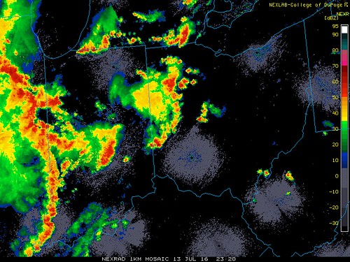
Toledo Weather - Wed, Jul 13, 2016
It was a tough evening in Monroe County with the heavy rainfall, wind damage, and a blizzard.
Local Storm Report
Issued: National Weather Service
07/13/2016 0725 PM
Monroe, Monroe County.
Blizzard, reported by Emergency Mngr.
Several reports of power lines and trees down Monroe County... Dundee
special weather statement
national weather service cleveland oh
753 pm edt wed jul 13 2016
ohz003-006>008-017-018-027-028-036-140030-
ottawa-hancock-marion-wyandot-lucas-wood-sandusky-seneca-crawford-
753 pm edt wed jul 13 2016
...a strong thunderstorm will affect marion...sandusky...wyandot...
ottawa...wood...lucas...hancock...crawford and seneca counties...
at 750 pm edt...strong thunderstorms were over
findlay...tiffin...prospect...and near bowling green moving
northeast at 30 mph. winds in excess of 40 mph and pea size hail are
possible with these storms. brief heavy rainfall of two inches per
hour could cause reduced visibilities and minor ponding on roadways.
these storms will continue over the region through 900 pm. stay
tuned to noaa weather radio for further updates.
lat...lon 4116 8380 4172 8387 4173 8346 4162 8341
4150 8341 4146 8334 4150 8308 4073 8272
4071 8278 4071 8285 4068 8286 4064 8296
4043 8303 4048 8325 4051 8325 4051 8342
4068 8342 4071 8348 4082 8351 4082 8388
time...mot...loc 2350z 221deg 24kt 4113 8364
$$
jamison
hazardous weather outlook
hazardous weather outlook
national weather service cleveland oh
116 pm edt wed jul 13 2016
lez142>144-162>164-ohz003-006>009-017>019-027>030-036-037-047-141730-
lake erie nearshore waters from maumee bay to reno beach oh-
lake erie nearshore waters from reno beach to the islands oh-
lake erie nearshore waters from the islands to vermilion oh-
lake erie open waters from maumee bay to reno beach oh-
lake erie open waters from reno beach to the islands oh-
lake erie open waters from the islands to vermilion oh-lucas-wood-
ottawa-sandusky-erie-hancock-seneca-huron-wyandot-crawford-richland-
ashland-marion-morrow-knox-
116 pm edt wed jul 13 2016
this hazardous weather outlook is for lake erie...north central
ohio and northwest ohio.
.day one...this afternoon and tonight.
there is a slight chance of severe weather this evening mainly in
the form of damaging winds.
.days two through seven...thursday through tuesday.
no hazardous weather is expected at this time.
.spotter information statement...
spotter activation is not expected at this time.
Monroe County is getting drenched.
flash flood warning
national weather service detroit/pontiac mi
753 pm edt wed jul 13 2016the national weather service in detroit/pontiac has issued a
- flash flood warning for...
monroe county in southeastern michigan...
- until 1045 pm edt
- at 752 pm edt...doppler radar indicated thunderstorms producing
heavy rain across the warned area. between one and two inches of
rain has already fallen. flash flooding is expected to begin
shortly.
- some locations that will experience flooding include...
monroe...flat rock...milan...dundee...carleton...temperance...
ida...luna pier...petersburg...maybee...ottawa lake...
lambertville...la salle...erie...rockwood...south rockwood...
estral beach...samaria...azalia and oakville.additional rainfall amounts of an inch or more are possible in the
warned area.
Local Storm Report:
07/13/2016 0705 PM
Ottawa, Putnam County.
Thunderstorm wind gust m55 mph, reported by trained spotter.
With outflow ahead of the storm.
~7:20 p.m.
TOL:
Jul 13, 2016 4:52 pm
Weather : Fair
Temperature : 92 F
Humidity : 46%
Wind Speed : S 12 mph - Gust 21 mph
Barometer : 29.84 in
Dewpoint: 68 F
Visibility : 10.00 statute miles
Heat Index : 96 F
(formerly Metcalf Airport)
Jul 13, 2016 4:53 pm
Weather : Fair
Temperature : 92 F
Humidity : 47%
Wind Speed : S 10 mph
Barometer : 29.85 in
Dewpoint: 69 F
Visibility : 10.00 statute miles
Heat Index : 97 F
(near Lambertville)
Jul 13, 2016 5:15 pm
Weather : Fair
Temperature : 92 F
Humidity : 47%
Wind Speed : SW 7 mph
Barometer : 29.85 in
Dewpoint: 69 F
Visibility : 10.00 statute miles
Heat Index : 97 F
Toledo Air Show this weekend.
http://toledoairshow.com/
Gates open both days at 9:00 a.m.
Toledo Forecast - Last Update: Jul 13, 2016 3:42 pm
- Saturday:
- Morning: Partly cloudy, with a low around 60.
- Afternoon: Mostly sunny, with a high near 80.
- Sunday:
- Morning: Partly cloudy, with a low around 62.
- Afternoon: Mostly sunny, with a high near 85.
Even Sunday's mid to late afternoon high temp should feel a little better than this afternoon's weather, which currently has temps in the low 90s and heat index values in the mid to upper 90s.
TOL:
Jul 13, 2016 3:52 pm
Weather : Fair
Temperature : 90 F
Humidity : 50%
Wind Speed : SW 13 mph
Barometer : 29.90 in
Dewpoint: 69 F
Visibility : 10.00 statute miles
Heat Index : 95 F
(formerly Metcalf Airport)
Jul 13, 2016 3:53 pm
Weather : Fair
Temperature : 92 F
Humidity : 47%
Wind Speed : SW 12 mph - Gust 23 mph
Barometer : 29.91 in
Dewpoint: 69 F
Visibility : 10.00 statute miles
Heat Index : 97 F
(near Lambertville)
Jul 13, 2016 4:15 pm
Weather : Partly Cloudy
Temperature : 91 F
Humidity : 49%
Wind Speed : SSW 8 mph - Gust 16 mph
Barometer : 29.89 in
Dewpoint: 69 F
Visibility : 10.00 statute miles
Heat Index : 96 F
hazardous weather outlook
national weather service cleveland oh
343 am edt wed jul 13 2016
for lake erie...north central
ohio...northeast ohio...northwest ohio and northwest pennsylvania.
.day one...today and tonight.
there is a marginal risk for severe thunderstorms today. the main
threat will be damaging wind gusts.
.days two through seven...thursday through tuesday.
there is a marginal risk for severe thunderstorms today. the main
threat will be damaging wind gusts.
.spotter information statement...
spotter activation is not expected at this time.
Toledo 7-day forecast
Last Update: Jul 13, 2016 6:15 am
Today: A chance of showers and thunderstorms. Partly sunny, with a high near 92. Southwest wind 8 to 11 mph. Chance of precipitation is 50%. New rainfall amounts between a tenth and quarter of an inch, except higher amounts possible in thunderstorms.
Tonight: A chance of showers and thunderstorms. Mostly cloudy, with a low around 72. Southwest wind 9 to 11 mph. Chance of precipitation is 50%. New rainfall amounts between a tenth and quarter of an inch, except higher amounts possible in thunderstorms.
Thursday: A chance of showers and thunderstorms. Partly sunny, with a high near 90. West wind 10 to 13 mph. Chance of precipitation is 50%. New rainfall amounts between a tenth and quarter of an inch, except higher amounts possible in thunderstorms.
Thursday Night: Partly cloudy, with a low around 65. Southwest wind 8 to 13 mph.
Friday: Mostly sunny, with a high near 81. West wind 7 to 14 mph.
Friday Night: Partly cloudy, with a low around 61.
Saturday: Mostly sunny, with a high near 80.
Saturday Night: Partly cloudy, with a low around 63.
Sunday: Mostly sunny, with a high near 85.
Sunday Night: A chance of showers and thunderstorms. Mostly cloudy, with a low around 67. Chance of precipitation is 40%.
Monday: A chance of showers and thunderstorms. Partly sunny, with a high near 84. Chance of precipitation is 30%.
Monday Night: Mostly cloudy, with a low around 65.
Tuesday: A chance of showers and thunderstorms. Mostly sunny, with a high near 86. Chance of precipitation is 30%.
fxus61 kcle 131144
afdcle
area forecast discussion
national weather service cleveland oh
744 am edt wed jul 13 2016
synopsis...
high pressure over the central appalachian mountains will move
little over the next twenty four hours. a cold front will move
southeast toward the area thursday. a trough of low pressure will
move southeast across the area friday. high pressure will then
build east across the area over the weekend.
&&
near term /until 6 pm this evening/...
a narrow line of showers continues to move east mainly across the
extreme northern tier counties and adjacent lake erie. most of it
is probably just sprinkles. current forecast updated to account
for these brief showers. otherwise, no other major changes at this
time.
previous discussion...
surface high pressure will continue to be
the dominant weather feature across the forecast area today. the
warm tropical southwest flow with dewpoint temperatures in the
lower 70s will continue today and help to keep the atmosphere
unstable through the day. however, atmosphere remains fairly well
capped through much of the day and then begins to break down
toward mid afternoon. this is when we could see a brief period of
showers and thunderstorms developing but widely scattered across
the area. storm prediction center has the forecast area in a
marginal threat for severe weather today. but as mentioned, that
all hinges on when the cap will break down supporting convection.
otherwise, it will be another hot one with muggy conditions. as
dewpoints remain in the lower 70s, heat index values will be well
into the upper 90s today.
&&
short term /6 pm this evening through saturday night/...
a broad upper level trough will swing through the area thursday
and friday forcing some cooler air back into the region. in the
mean time, surface high pressure will dominate the forecast area
through the night into thursday morning with a muggy air mass
dominating the forecast area. instability will be present in the
tropical air mass but may have difficulty supporting convection
due the cap holding strong. some scattered activity is expected
overnight and a better chance is expected thursday ahead of the
cold front. storm prediction center has the local area in a
marginal risk for severe thunderstorms again tomorrow ahead of the
cold front. thursday will have a better chance for the severe
activity to develop and main threats will be high winds and hail.
once the cold front slips by thursday...cooler air will move into
the region. a trough of low pressure will move southeast across
the area friday and could support a minor threat for showers and
thunderstorms. high pressure will begin to build into the region
from the west saturday into saturday night.
leaning toward persistence in the temperature forecast and remain
slightly warmer than guidance. cold air advection arrives thursday
night and continues through saturday night in the wake of the cold
front so will drop temperatures into the 80s for highs and lows in
the 60s.
&&
long term /sunday through tuesday/...
a weak trough aloft is expected to hang on across the eastern great
lakes and northeast states early in the week. a short wave is
progged to drop across the upper midwest and great lakes later
sunday into monday. convection is likely to develop in the vicinity
of the short wave but could run out well ahead of the short wave.
will have a chance of showers and thunderstorms sunday night into
monday. we will remain precariously between the heat ridge in the
middle of the country and the weak trough aloft in the northeast and
cannot rule out thunderstorms in the weak baroclinic zone right into
midweek. will keep a low pop chance of showers and thunderstorms
tuesday.
&&
aviation /12z wednesday through sunday/...
a decent size patch of lower clouds, ifr and low mvfr, has
expanded across the upper ohio valley and northwest pa. these
lower clouds will clip kcak and kyng this morning but should stay
south of keri. elsewhere, scattered to broken cumulus will
develop in the airmass which has moistened up. showers and
thunderstorms over the mississippi valley will likely reach
northwest ohio by late afternoon. not sure how far east they will
hold together this evening and made the forecast less definitive
farther east (prob30 and vicinity).
outlook...areas of non-vfr possible thursday in showers and
thunderstorms. non-vfr possible across ne oh/nw pa friday.
&&
marine...
a relatively light south flow will become more southwesterly and
increase in speed today and again on thursday ahead of a weak cold
front. the southwest direction will keep the larger waves on the
east and north side of the lake and we should be able to avoid a
small craft advisory until perhaps on friday when the flow will
become more westerly. this would bring the larger waves into the
south shore, especially east of cleveland.
high pressure will build across the eastern great lakes on saturday.
the flow will veer northwest and perhaps north but the gradient
should be light. the flow will come around from the south on sunday
as the ridge moves east but the flow could be light enough for a
lake breeze.
&&
cle watches/warnings/advisories...
oh...none.
pa...none.
marine...none.
&&
$$
synopsis...lombardy
near term...lombardy
short term...lombardy
long term...kosarik
aviation...kosarik
marine...kosarik
From JR's : articles
2046 words - 12877 chars
- 11 min read
created on
updated on
- #
source
- versions
Related articles
Toledoans whine about summer weather - Sep 02, 2014
Halloween trick-or-treat 2014 - Oct 29, 2014
Toledo rib-off-gate - Oct 08, 2013
Rescheduling Trick-or-Treat because of the forecast for rain - Nov 04, 2013
Dog grooming at Clip-N-Dales - Nov 01, 2013
more >>