You're viewing old version number 1. - Current version
Toledo weather mon jul 18, 2016
not a drought-breaker, but it appears that some areas around toledo will receive some rain ... now.
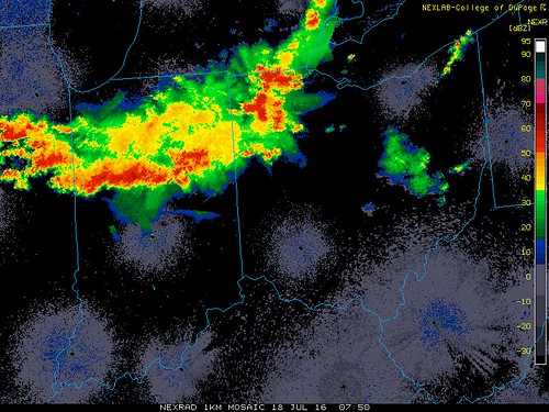
at 4:02 a.m., the Cle NWS issued a Severe Thunderstorm Warning for Lucas County until 4:30 a.m. Radar detected a severe thunderstorm near Sylvania.
special weather statement
national weather service cleveland oh
353 am edt mon jul 18 2016a cluster of strong thunderstorms will move east across the area
and produce wind gusts to 45 mph. locally heavy rain and cloud to
ground lightning are likely with the thunderstorms as well.
ponding of water is likely on roadways and in poor drainage areas.
the thunderstorms are expected to be east of the area by 5 am
this morning.
about the warning
Severe Thunderstorm Warning
Issued: 4:02 AM EDT Jul. 18, 2016 – National Weather ServiceThe National Weather Service in Cleveland has issued a
- Severe Thunderstorm Warning for...
Lucas County in northwestern Ohio...
- until 430 am EDT
- at 402 am EDT... a severe thunderstorm was located over
Sylvania... or 7 miles west of Toledo... moving east at 35 mph.Hazard... 60 mph wind gusts and quarter size hail.
Source... radar indicated.
Impact... hail damage to vehicles is expected. Expect wind damage
to roofs... siding and trees.
- Locations impacted include...
Toledo... Swanton... Perrysburg... Oregon... Sylvania... Rossford...
Waterville... Northwood... Whitehouse... Holland... Maumee...
Ottawa Hills... Walbridge... Millbury... Clay Center... Berkey...
Harbor View... Williston... Reno Beach and Neapolis.
watch never issued
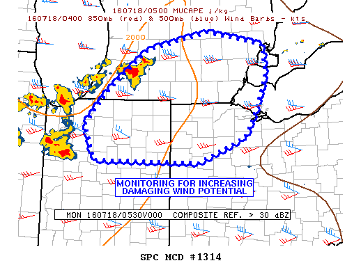
md 1314 concerning severe potential...watch possible for srn lower mi...nrn indiana...nwrn oh
mesoscale discussion 1314
nws storm prediction center norman ok
1251 am cdt mon jul 18 2016
areas affected...srn lower mi...nrn indiana...nwrn oh
concerning...severe potential...watch possible
valid 180551z - 180745z
probability of watch issuance...40 percent
summary...a few damaging wind gusts are possible tonight...and the
area is being monitored for a watch...conditional on further storm
organization.
discussion...several clusters of storms have gradually increased in
coverage over the past hour with cooling tops on ir imagery. most
recently...development has increased over swrn lower mi...near a
confluence line and also on the srn periphery of the upper shortwave
trough influence. the grr and dtx vwps show 30-40 kt winds in the
lower part of the troposphere and the instability axis extends newd
into lower mi. this setup may support a damaging wind threat if the
activity upstream can produce a substantial cold pool. any hail
threat should be marginal.
..jewell/edwards.. 07/18/2016
...please see www.spc.noaa.gov for graphic product...
attn...wfo...cle...dtx...iwx...grr...
lat...lon 40758421 40798643 41348665 41908615 42588530 42888399
42668279 42198273 41708290 41178319 40758421
From JR's : articles
414 words - 2924 chars
- 2 min read
created on
- #
source
- versions
Related articles
Severe weather threat for Sun, Nov 17, 2013 - Nov 18, 2013
Nov 17, 2013 Toledo area weather notes - Mar 03, 2014
Posts related to Nov 17, 2013 severe weather - Nov 21, 2013
Toledo area weather for early December 2013 - Dec 05, 2013
Mon, Dec 9, 2013 winter storm forecast for Sat, Dec 14 - Dec 14, 2013
more >>