Toledo weather - thu, jul 21, 2016
special weather statement
national weather service cleveland oh
432 pm edt thu jul 21 2016
ohz003-006-007-212115-
ottawa-lucas-wood-
432 pm edt thu jul 21 2016
...a line of strong thunderstorms will affect ottawa...northern wood
and lucas counties...
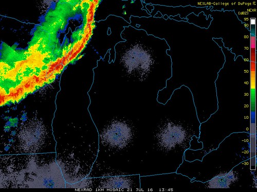
at 431 pm edt...a line of strong thunderstorms was along a line
extending from near milan to wauseon...and moving southeast at 20
mph.
winds in excess of 40 mph are possible with these storms.
locations impacted include...
toledo...bowling green...perrysburg...oregon...sylvania...rossford...
waterville...northwood...whitehouse...genoa...holland...weston...
maumee...ottawa hills...walbridge...millbury...haskins...luckey...
grand rapids and tontogany.
these storms may intensify...so be certain to monitor local radio and
tv stations...as well as local cable tv outlets...for additional
information and possible warnings from the national weather service.
lat...lon 4172 8387 4172 8341 4173 8339 4165 8318
4175 8313 4176 8308 4175 8308 4172 8309
4172 8313 4166 8317 4161 8310 4150 8334
4150 8341 4147 8342 4127 8388
time...mot...loc 2031z 301deg 19kt 4206 8361 4156 8417
$$
manning
urgent - weather message
national weather service cleveland oh
321 pm edt thu jul 21 2016
...dangerous heat is on tap for the region friday and saturday...
ohz003-006>011-017>021-027>031-036>038-047-220330-
/o.new.kcle.ht.y.0001.160722t1500z-160724t0100z/
lucas-wood-ottawa-sandusky-erie-lorain-cuyahoga-hancock-seneca-
huron-medina-summit-wyandot-crawford-richland-ashland-wayne-
marion-morrow-holmes-knox-
including the cities of...toledo...bowling green...port clinton...
fremont...sandusky...lorain...cleveland...findlay...tiffin...
norwalk...medina...akron...upper sandusky...bucyrus...mansfield...
ashland...wooster...marion...mount gilead...millersburg...
mount vernon
321 pm edt thu jul 21 2016
...heat advisory in effect from 11 am friday to 9 pm edt
saturday...
the national weather service in cleveland has issued a heat
advisory...which is in effect from 11 am friday to 9 pm edt
saturday.
- temperature...afternoon highs in the low to mid 90s.
- maximum heat index values...from 100 to 104.
- impacts...there is a high risk of heat related illnesses for
people with prolonged outdoor exposure...or to those without air
conditioning. the elderly...small children are especially
susceptible to the heat. make sure outdoor pets have plenty of
water and shade.
precautionary/preparedness actions...
a heat advisory means that the combination of high temperatures
and high humidity will combine to create a situation in which
heat illnesses are possible. drink plenty of fluids...stay in an
air-conditioned room...stay out of the sun...and check up on
relatives and neighbors.
take extra precautions...if you work or spend time outside.
when possible...reschedule strenuous activities to early morning
or evening. know the signs and symptoms of heat exhaustion and
heat stroke. wear light weight and loose fitting clothing when
possible and drink plenty of water.
to reduce risk during outdoor work...the occupational safety
and health administration recommends scheduling frequent rest
breaks in shaded or air conditioned environments. anyone overcome
by heat should be moved to a cool and shaded location. heat
stroke is an emergency...call 9 1 1.
&&
$$
hazardous weather outlook
hazardous weather outlook
national weather service cleveland oh
321 pm edt thu jul 21 2016
ohz003-006>011-018-019-221930-
lucas-wood-ottawa-sandusky-erie-lorain-cuyahoga-seneca-huron-
321 pm edt thu jul 21 2016
...heat advisory in effect from 11 am friday to 9 pm edt saturday...
this hazardous weather outlook is for north central
ohio...northeast ohio and northwest ohio.
.day one...this afternoon and tonight.
thunderstorms are expected this evening through the overnight.
the storm prediction center has indicated that there is a slight
chance that some storms could become severe. the favored timing
for the strongest storms would likely be from late this afternoon
into the early overnight hours. the main threat would be strong
damaging winds and hail.
.days two through seven...friday through wednesday.
please listen to noaa weather radio or go to weather.gov on the
internet for more information about the following hazards.
heat advisory.
hot humid conditions will arrive friday and continue into the
weekend. afternoon highs friday will reach the low to mid 90s away
from lake erie pushing heat index values to between 95 and 104
degrees. saturday and sunday, heat index values are expected to
top out between 95 and 100 saturday and sunday. this will make it
feel very uncomfortable and increase risk for heat stroke.
also...thunderstorms are possible friday afternoon and evening. a
few of these thunderstorms may become severe with large hail and
strong damaging winds.
.spotter information statement...
spotter activation is not expected at this time.

md 1349 concerning severe potential...watch possible for extreme nern il...portions of srn lower mi...nrn indiana...nwrn oh...adjacent le
mesoscale discussion 1349
nws storm prediction center norman ok
0123 pm cdt thu jul 21 2016
areas affected...extreme nern il...portions of srn lower mi...nrn
indiana...nwrn oh...adjacent le
concerning...severe potential...watch possible
valid 211823z - 212030z
probability of watch issuance...40 percent
summary...thunderstorm coverage is expected to increase this
afternoon with a risk for isolated damaging winds and perhaps large
hail. it remains unclear whether a watch will be needed...however
thunderstorm trends will be monitored.
discussion...the leading edge of a broken line of thunderstorms
continues to move southeast at 35 mph across southwest lower
mi/northwest indiana with several cells developing ahead of the line
in the vicinity. downstream...strong heating of upper 60s/lower 70s
surface dew points has yielded moderate-strong surface-based
instability. environmental wind fields within the discussion area
remain modest at best...and the latest kiwx vwp indicates around 20
kts of deep-layer shear.
a pronounced cold pool associated with the long-lived mcs continues
to move southeast and is expected to result in an increase in
thunderstorm coverage during the next few hours as it encounters an
uncapped air mass as indicated by a deepening cumulus field on
visible imagery. clusters of strong/isolated severe storms will be
possible with severe winds the primary threat...though marginally
severe hail will also be possible with the strongest storms.
it remains unclear whether a watch will be needed given concerns
about the overall severe coverage...and convective trends will
continue to be monitored.
..bunting/hart.. 07/21/2016
...please see www.spc.noaa.gov for graphic product...
attn...wfo...cle...dtx...iwx...grr...lot...
lat...lon 40778461 40818707 41348769 41768728 41798659 41998605
42498469 42668376 42558311 41948323 41408255 41038258
40888299 40778461

The SPC extended the Slight Risk for severe weather today/tonight further southward to include the Toledo area.
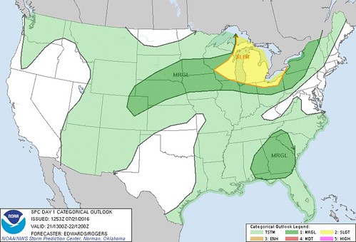
Excerpts from the 8:53 a.m., Thu, Jul 21, 2016 SPC Convective Outlook:
scattered severe thunderstorms with mainly damaging wind are possible through this evening from parts of the upper great lakes region to ohio.
Our temps are forecast to reach the low 90s over the next four days.
Toledo Forecast - Issued by the Cleveland NWS - Last Update: Jul 21, 2016 6:52 am
Today: Mostly sunny, with a high near 91. Southwest wind 6 to 14 mph.
Tonight: A chance of showers and thunderstorms, mainly after 1am. Mostly cloudy, with a low around 70. Southwest wind 8 to 11 mph. Chance of precipitation is 30%. New rainfall amounts between a tenth and quarter of an inch, except higher amounts possible in thunderstorms.
Friday: A chance of showers and thunderstorms, mainly after 5pm. Partly sunny, with a high near 92. Heat index values as high as 100. Southwest wind 10 to 13 mph. Chance of precipitation is 30%. New rainfall amounts between a quarter and half of an inch possible.
Friday Night: A chance of showers and thunderstorms, mainly before 9pm. Mostly cloudy, with a low around 69. West wind 5 to 8 mph. Chance of precipitation is 30%. New rainfall amounts of less than a tenth of an inch, except higher amounts possible in thunderstorms.
Saturday: Mostly sunny, with a high near 92. Light and variable wind becoming west around 5 mph in the afternoon.
Saturday Night: A chance of showers and thunderstorms, mainly after midnight. Mostly cloudy, with a low around 71. Chance of precipitation is 30%. New rainfall amounts of less than a tenth of an inch, except higher amounts possible in thunderstorms.
Sunday: A chance of showers and thunderstorms. Partly sunny, with a high near 91. Chance of precipitation is 40%.
From JR's : articles
1255 words - 8859 chars
- 6 min read
created on
updated on
- #
source
- versions
Related articles
Severe weather threat for Sun, Nov 17, 2013 - Nov 18, 2013
Nov 17, 2013 Toledo area weather notes - Mar 03, 2014
Posts related to Nov 17, 2013 severe weather - Nov 21, 2013
Toledo area weather for early December 2013 - Dec 05, 2013
Mon, Dec 9, 2013 winter storm forecast for Sat, Dec 14 - Dec 14, 2013
more >>