Toledo forecasts issued on Wed, Jan 22, 2014
Solid, old-fashioned, cold and somewhat snowy, winter weather pattern continues for at least seven more days.
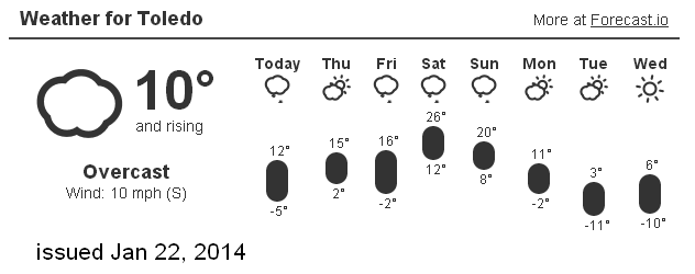
From the Forecast.io page at ToledoWX at around 1:45 p.m. EST, on Jan 22, 2014:
Clev NWS forecast for Toledo:
Toledo 7-day forecast
Last Update: Jan 22, 2014 12:42 pm
This Afternoon: A chance of snow showers, mainly after 4pm. Cloudy, with a high near 14. Wind chill values as low as -3. South wind around 13 mph. Chance of precipitation is 30%. Total daytime snow accumulation of less than a half inch possible.
Tonight: Snow showers likely, mainly after 4am. Cloudy, with a low around 5. Wind chill values as low as -12. South wind 6 to 15 mph becoming northwest after midnight. Chance of precipitation is 70%. New snow accumulation of less than one inch possible.
Thursday: A chance of snow showers, mainly before noon. Cloudy, with a high near 14. Wind chill values as low as -12. Northwest wind 10 to 16 mph. Chance of precipitation is 40%. New snow accumulation of less than a half inch possible.
Thursday Night: Mostly cloudy, with a low around -5. Wind chill values as low as -24. West wind 8 to 16 mph.
Friday: Partly sunny, with a high near 16. Windy, with a southwest wind 16 to 21 mph increasing to 23 to 28 mph in the afternoon.
Friday Night: Snow showers likely, mainly after 1am. Cloudy, with a low around 14. Breezy. Chance of precipitation is 70%.
Saturday: A chance of snow showers. Cloudy, with a high near 26. Breezy. Chance of precipitation is 40%.
Saturday Night: Mostly cloudy, with a low around 1. Breezy.
Sunday: A chance of snow showers. Cloudy, with a high near 18. Chance of precipitation is 50%.
Sunday Night: A chance of snow showers. Cloudy, with a low around 2. Chance of precipitation is 30%.
Monday: A chance of snow showers. Mostly cloudy, with a high near 12. Chance of precipitation is 30%.
Monday Night: A chance of snow showers. Cloudy, with a low around -4. Chance of precipitation is 30%.
Tuesday: Mostly cloudy and cold, with a high near 9.
page created: Jan 22, 2014 - 1:45 p.m. EST
fxus61 kcle 221751
afdcle
area forecast discussion
national weather service cleveland oh
1251 pm est wed jan 22 2014
synopsis...
arctic high pressure will move across the ohio valley today...then
move off the southeast coast tonight. this will allow a clipper
system to move across the area overnight.
&&
near term /until 6 pm this evening/...
a few light snow showers remain...mainly over lake county...and
will continue to slowly spread northeast up the shoreline ahead of
the building ridge into this evening. we may even see this band
start to increase in strength as the system moisture arrives this
evening. snow can bee seen approaching from the west but still
expect it take until at least 4-5 pm for anything to start
reaching the ground in nw ohio.
the wind chill advisory was cancelled this morning but we may be
close to needing another one across western portions of the area
tonight.
original discussion... with most locations between zero to -5f left the
wind chill advisory going for this morning even though the winds
are marginal. but even after the advisory expires...wind chill
temps will still remain below zero over most of the area.
high pressure...now over the mid mississippi valley...will move
into the ohio valley by daybreak cutting off the scattered light
snow off lake huron. left chance of flurries over the central and
eastern lake shore counties for this morning. high pressure will
move quickly east allowing next clipper system to move into the
central great lakes this afternoon. expect snow to move into nw
ohio late afternoon or early evening.
&&
short term /6 pm this evening through saturday night/...
little change in the short term as long wave trough will remain over
the great lakes allowing a series of clippers to move across the
area. models in reasonably good agreement on the track and timing
of the first clipper due tonight. models move low into nw ohio
toward midnight local...then across northern ohio into nw pa
overnight. expect a quick inch or two from the clipper overnight
with some lingering lake enhanced snow showers in the east lingering
into thursday. another break on friday as high pressure moves
across the tennessee valley. models continue to be in good
agreement with another shot of arctic air due on saturday...with the
850mb temps plunging to minus 24c by daybreak sunday.
&&
long term /sunday through tuesday/...
upper level pattern keeps upper level trough holding tight over the
eastern united states through this entire extended period. another
shortwave trough will dig into the eastern states by tuesday morning
and this will help to re-amplify the ridge along the west coast.
as of right now...there does not appear to be any relief in sight
for an end to this cold weather pattern that we have seen so far. a
look at the overall upper level pattern over the northern hemisphere
indicates flow will become more zonal in very broad trough over the
entire united states by next weekend.
the trend indicates another ridge will build along the west coast
and this will only help to deepen the trough once again for the
eastern united states. another issue at hand is high pressure is
expected to develop just north of the bering sea and drift toward
the north pole. lets hope this long resident high does not get
caught up in the mean flow and head our way. it will have plenty of
time to build up an extremely cold air mass. keep that wood pile
stocked...we may be in for the long haul.
models indicate low pressure will move east across the forecast area
on sunday and bring with it another round of snow to the forecast
area. following the low will be another surge of arctic air that
will push into monday and tuesday. yet another low pressure system
will race in behind the initial low pressure system and affect the
area by wednesday.
i will keep a mention of snow showers each day for the extended
period. i probably could go with likely pops for sunday but will
just keep it chance for now until we get a better look at the exact
track of the low and moisture support associated with the storm
system.
as mentioned above...cold air will return for monday and tuesday as
low pressure exits to the east. 850 mb temperatures plummet to -20
to -22 c across the area bringing in strong cold air advection.
warmer air starts to return again tuesday night into wednesday ahead
of the next low pressure system.
&&
aviation /18z wednesday through monday/...
clouds moisture and snow moving into the area from the northwest
this afternoon ahead of another clipper system dropping through
the great lakes region. core of the moisture will pass to the
south but the low will draw it back across the area thursday. in
short having a tough time finding an end to the snow with the
system through 18z thursday at least. across the east in the
sun...convective cu developing mvfr cigs around bkn025. will go
with conditions dropping to mvfr toledo and fdy by 20z with mvfr
conditions (other than the cu) moving east to kcle after 00z.
otherwise after system moves in expect widespread mvfr and
scattered ifr through the balance of the period.
outlook...non vfr thursday night...then saturday through monday.
&&
marine...
winds will be on the increase through the next couple days as high
pressure moves by to the south and low pressure moves east across
the great lakes region with associated cold front. expecting winds
to develop from the southwest friday into friday night and become
strong enough to support gale force winds. winds will drop off for a
period during cold frontal passage on saturday morning and then
increase again to gales after frontal passage. so...will go ahead
and hoist a gale watch for friday afternoon into saturday. winds
should diminish saturday night below gale force and remain that way
through sunday.
&&
cle watches/warnings/advisories...
oh...none.
pa...none.
marine...gale watch from friday afternoon through saturday evening for
lez061-142>149-162>169.
&&
$$
synopsis...djb
near term...djb/kec
short term...djb
long term...lombardy
aviation...tk
marine...lombardy
From JR's : articles
1380 words - 8197 chars
- 7 min read
created on
- #
source
- versions
Related articles
Severe weather threat for Sun, Nov 17, 2013 - Nov 18, 2013
Nov 17, 2013 Toledo area weather notes - Mar 03, 2014
Posts related to Nov 17, 2013 severe weather - Nov 21, 2013
Toledo area weather for early December 2013 - Dec 05, 2013
Mon, Dec 9, 2013 winter storm forecast for Sat, Dec 14 - Dec 14, 2013
more >>