You're viewing old version number 6. - Current version
Toledo Weather - Tue, Feb 4, 2014
hazardous weather outlook
national weather service cleveland oh
403 am est tue feb 4 2014
ohz003-006>009-017>019-027>030-036-037-047-050915-
lucas-wood-ottawa-sandusky-erie oh-hancock-seneca-huron-wyandot-
crawford-richland-ashland-marion-morrow-knox-
403 am est tue feb 4 2014
...winter storm warning in effect from 5 pm this afternoon to 5 pm
est wednesday...
this hazardous weather outlook is for north central ohio and
northwest ohio.
.day one...today and tonight.
please listen to noaa weather radio or go to weather.gov on the
internet for more information about the following hazards.
winter storm warning.
.days two through seven...wednesday through monday.
please listen to noaa weather radio or go to weather.gov on the
internet for more information about the following hazards.
winter storm warning.
.spotter information statement...
spotter activation is not expected at this time.
urgent - winter weather message
national weather service cleveland oh
322 am est tue feb 4 2014
ohz003-006>009-017>019-027>030-036-037-047-041630-
/o.ext.kcle.ws.w.0003.140204t2200z-140205t2200z/
lucas-wood-ottawa-sandusky-erie oh-hancock-seneca-huron-wyandot-
crawford-richland-ashland-marion-morrow-knox-
including the cities of...toledo...bowling green...port clinton...
fremont...sandusky...findlay...tiffin...norwalk...
upper sandusky...carey...bucyrus...mansfield...ashland...marion...
mount gilead...mount vernon
322 am est tue feb 4 2014
...winter storm warning now in effect from 5 pm this afternoon to
5 pm est wednesday...
- accumulations...total of 6 to 9 inches likely.
- timing...late today into wednesday afternoon.
- winds...northeast to north 10 to 20 mph increasing to 15 to 25
mph by wednesday morning.
- temperatures...will range from the low to mid 20s.
- visibilities...down to a quarter of a mile at times.
- impacts...snow covered roads will make driving slow and
hazardous. some blowing and drifting snow could make travel
difficult.
precautionary/preparedness actions...
you should use extreme caution if travel is unavoidable. stay
tuned to noaa weather radio or your favorite weather source for
further details or updates from the national weather service.
Toledo 7-day forecast
Last Update: Feb 4, 2014 6:07 am
Today: A chance of snow, mainly after 5pm. Mostly cloudy, with a high near 24. Calm wind becoming northeast around 6 mph in the afternoon. Chance of precipitation is 30%. Total daytime snow accumulation of less than a half inch possible.
Tonight: Snow, mainly after 8pm. Low around 18. Northeast wind 8 to 13 mph. Chance of precipitation is 100%. New snow accumulation of 3 to 7 inches possible.
Wednesday: Snow, mainly before 3pm. High near 25. North wind 11 to 15 mph. Chance of precipitation is 80%. New snow accumulation of 1 to 3 inches possible.
Wednesday Night: A chance of snow, mainly before 7pm. Mostly cloudy, with a low around 5. Wind chill values as low as -3. Northwest wind 6 to 9 mph. Chance of precipitation is 30%.
Thursday: Partly sunny, with a high near 17. West wind 7 to 13 mph.
Thursday Night: Mostly cloudy, with a low around 0.
Friday: Partly sunny, with a high near 17.
Friday Night: A chance of snow. Mostly cloudy, with a low around 2. Chance of precipitation is 30%.
Saturday: A chance of snow. Mostly cloudy, with a high near 22. Chance of precipitation is 30%.
Saturday Night: A chance of snow. Cloudy, with a low around 9. Chance of precipitation is 30%.
Sunday: A chance of snow. Mostly cloudy, with a high near 23. Chance of precipitation is 30%.
Sunday Night: A chance of snow. Mostly cloudy, with a low around 10. Chance of precipitation is 30%.
Monday: Mostly sunny, with a high near 23.
fxus61 kcle 041129
afdcle
area forecast discussion
national weather service cleveland oh
629 am est tue feb 4 2014
synopsis...
a low will track northeast from the gulf into west virginia by
daybreak wednesday then off the new england coast by evening. high
pressure will spread east across ohio thursday into thursday night
then shift north friday. another low will move out of the gulf and
track across virginia late sunday and off of new england by early
monday.
&&
near term /through tonight/...
for the most part...things look on track for snow to begin to spread
ene across the west half of the cwa by 00z this eve. the ongoing
forecast looks reasonable so just minor adjustments to pops.
after cold morning lows...temps today should be able to recover back
into the mid to upper 20s. the warmer readings will be in the east
where the clouds will be slower to thicken.
&&
short term /wednesday through friday night/...
the nam lifts the low a little further nw than the gfs bringing
somewhat warmer air into mahoning and nearby co's which could cause
some mixing of wintry precip to occur but the gfs keeps it cold
enough aloft for just snow. for now will maintain consistency and
stay with just snow. the day shift can see which way the 12z model
runs go and make adjustments to precip type and accumulation if
necessary.
it still looks like about 4 to 6 inches of snow tonight and another
1 to 3 inches on wed with the 3 inches more likely for the ne part
of the cwa. in order to maintain continuity...will leave winter
storm headlines as is with this forecast package except to start
warning in the west at 22z and in the east at 01z.
moisture hangs around wed night into thu with marginal lake
enhancement conditions present. will increase pops some for wed
night and thu for the snowbelt where some areas could see another
inch or two of additional accumulation.
arctic air is again pulled down over the area late wed and wed night
in the wake of the departing low. lows of 5 to 10 degrees seem
likely for wed night except the lakeshore of the snowbelt will
probably hang up in a 10 to 13 degree range due to more cloud cover.
thu remains cold with highs likely to stay in the teens. high
pressure moves over the area for thu night to calm the winds so thu
night should be the coldest night with lows close to zero for much
of the cwa.
think the high will maintain dry conditions thu night into early fri
night. enough return moisture ahead of the next system shows up by
the end of fri night to warrant at least small chance pops for
mainly the west half by the end of fri night.
&&
long term /saturday through monday/...
the long term begins saturday with models showing high pressure
across the ohio valley. aloft heights show a broad upper trof
across the states and the airmass across the region will be moist.
with little forcing however will keep pops at low chance category.
sunday models out of phase however both the ecmwf and gfs show a
developing upper trof moving through the great lakes while a surface
low moves up the east coast. will need to watch the evolution of
this system but the current model runs are not quite as aggressive
in developing the storm as previous runs. still both models indicate
the potential for moisture getting into the area sunday associated
either with the surface low or the upper trof so will have higher
chance pops and favor the east half. sunday night and monday high
pressure builds across the area along with decreasing moisture.
&&
aviation /12z tuesday through saturday/...
significant winter storm set to move into the area mostly after
00z this evening. until then expect vfr conditions although cigs
will be lowering as moisture increases. brought mvfr into the west
around 23z dropping to ifr and below 02-04z time frame. at kcle
brought mvfr conditions in by 02z with ifr after 04z. for the
overnight expect moderate to occasionally heavy snow across the
area. ifr to persist into wednesday morning.
outlook...non vfr wednesday and then again on saturday.
&&
marine...
low pressure will pass southeast of the lake tuesday night and early
wednesday before moving off the delmarva/new england coast
wednesday afternoon. ahead of the storm...winds will be from the
northeast today...backing to northwest by wednesday afternoon.
strongest flow will be late tuesday night and early wednesday at 20
to 25 knots. northwest flow will back to westerly by thursday
morning and then southwest thursday afternoon as high pressure
builds into the lower ohio valley from the west. winds will remain
from the southwest at 10 to 20 knots friday and then drop off
saturday to around 10 knots as the high builds over the lake. no
headlines expected.
&&
cle watches/warnings/advisories...
oh...winter storm warning from 8 pm this evening to 5 pm est
wednesday for ohz010>014-020>023-031>033-038-089.
winter storm warning from 5 pm this afternoon to 5 pm est
wednesday for ohz003-006>009-017>019-027>030-036-037-047.
pa...winter storm warning from 8 pm this evening to 5 pm est
wednesday for paz001>003.
marine...none.
&&
$$
synopsis...adams
near term...adams
short term...adams
long term...tk
aviation...tk
marine...tk
Forecast.io hi-lo Toledo temp predictions as of 9:48 a.m., on Tue, Feb 4, 2014:
- today, Feb 4 : 23 and 7
- Wed, Feb 5 : 27 and 10
- Thu, Feb 6 : 11 and -3
- Fri, Feb 7 : 11 and -6
- Sat, Feb 8 : 19 and -5
- Sun, Feb 9 : 24 and 18
- Mon, Feb 10 : 19 and 7
- Tue, Feb 11 : 18 and 5
urgent - winter weather message
national weather service cleveland oh
332 pm est tue feb 4 2014
ohz003-006>009-017>019-027>030-036-037-047-050445-
/o.con.kcle.ws.w.0003.140204t2200z-140205t2200z/
lucas-wood-ottawa-sandusky-erie oh-hancock-seneca-huron-wyandot-
crawford-richland-ashland-marion-morrow-knox-
including the cities of...toledo...bowling green...port clinton...
fremont...sandusky...findlay...tiffin...norwalk...
upper sandusky...carey...bucyrus...mansfield...ashland...marion...
mount gilead...mount vernon
332 pm est tue feb 4 2014
...winter storm warning remains in effect until 5 pm est
wednesday...
- accumulations...total of 6 to 10 inches likely.
- timing...late today into wednesday afternoon.
- winds...northeast to north 10 to 20 mph increasing to 15 to 25
mph by wednesday morning.
- temperatures...will range from the low to mid 20s.
- visibilities...down to a quarter of a mile at times.
- impacts...snow covered roads will make driving slow and
hazardous. some blowing and drifting snow could make travel
difficult.
precautionary/preparedness actions...
you should use extreme caution if travel is unavoidable. stay
tuned to noaa weather radio or your favorite weather source for
further details or updates from the national weather service.
Toledo 7-day forecast
Last Update: Feb 4, 2014 3:36 pm
Late Afternoon: A chance of snow. Cloudy, with a high near 24. Northeast wind around 7 mph. Chance of precipitation is 30%. Total daytime snow accumulation of less than a half inch possible.
Tonight: Snow, mainly after 8pm. Low around 20. Northeast wind 8 to 14 mph. Chance of precipitation is 100%. New snow accumulation of 3 to 7 inches possible.
Wednesday: Snow, mainly before 3pm. High near 26. North wind 15 to 18 mph. Chance of precipitation is 80%. New snow accumulation of 1 to 3 inches possible.
Wednesday Night: A chance of snow, mainly before 7pm. Mostly cloudy, with a low around 9. Wind chill values as low as -2. North wind 7 to 10 mph becoming west after midnight. Chance of precipitation is 30%.
Thursday: Partly sunny, with a high near 14. West wind 9 to 11 mph.
Thursday Night: Mostly cloudy, with a low around -5.
Friday: Partly sunny, with a high near 14.
Friday Night: A chance of snow. Mostly cloudy, with a low around 1. Chance of precipitation is 30%.
Saturday: A chance of snow. Cloudy, with a high near 22. Chance of precipitation is 30%.
Saturday Night: A chance of snow. Cloudy, with a low around 10. Chance of precipitation is 30%.
Sunday: A chance of snow. Mostly cloudy, with a high near 21. Chance of precipitation is 30%.
Sunday Night: A chance of snow. Mostly cloudy, with a low around 4. Chance of precipitation is 30%.
Monday: Partly sunny, with a high near 20.
Monday Night: Mostly cloudy, with a low around 0.
Tuesday: Partly sunny, with a high near 21.
my comment in the winter weather discussion thread at ToledoTalk.com
The Storm Prediction Center issued a mesoscale discussion at 4:14 p.m. today, Feb 4 that barely includes the Toledo area.

Excerpts:
heavy snowfall will become common through 00z across srn/cntrl ind...and eventually into wrn/nrn oh.rates of 1-2 per inches per hr will become increasingly likely into the evening hrs /especially within concentrated snow bands/...affecting the indianapolis and dayton metro areas...as well as surrounding portions of srn/cntrl ind and w-cntrl/nwrn oh.
Toledo forecast issued at 3:36 p.m.
Tonight: Snow, mainly after 8pm. Low around 20. Northeast wind 8 to 14 mph. Chance of precipitation is 100%. New snow accumulation of 3 to 7 inches possible.
Wednesday: Snow, mainly before 3pm. High near 26. North wind 15 to 18 mph. Chance of precipitation is 80%. New snow accumulation of 1 to 3 inches possible.
I like that range: 4 to 10 inches. Sometimes, it's tough to pinpoint the forecast, even as the snow enters the area.
4 inches of snow at this point barely warrants the time to remove it.
I think the forecast means that Trilby, Toledo will receive 4 to 5 inches of snow, Viva, Toledo will receive 6 to 7 inches of snow, and Bowling Green will receive 8 to 9 inches of snow.
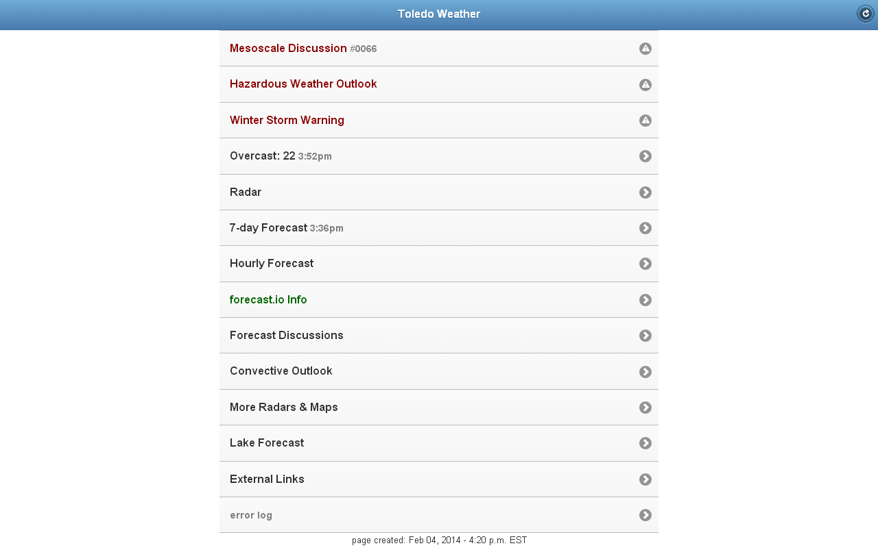
Screen shot of ToledoWX, taken on Tuesday afternoon, February 4, 2014:
Earlier, I overlooked mentioning this interesting nugget of info from this afternoon's area forecast discussion, issued by the Cleveland NWS:
... all snow and this includes the toledo and findlay area over to the cleveland area. there is the potential that these areas could see more snow than we are currently forecasting if the northeast flow down lake erie is enhanced by moisture flux from the lake.there are several significant cracks in the ice that should be significant for some reverse lake enhancement to develop overnight tonight. may need to up snow amounts in the northwest area.
From JR's : articles
2246 words - 14049 chars
- 12 min read
created on
updated on
- #
source
- versions
Related articles
Severe weather threat for Sun, Nov 17, 2013 - Nov 18, 2013
Nov 17, 2013 Toledo area weather notes - Mar 03, 2014
Posts related to Nov 17, 2013 severe weather - Nov 20, 2013
Toledo area weather for early December 2013 - Dec 05, 2013
Mon, Dec 9, 2013 winter storm forecast for Sat, Dec 14 - Dec 14, 2013
more >>